Labyrinth......this word evokes feelings of mystery and intrigue. It conjures up images of secret passageways winding through a maze. Does it get your attention? It did mine!
So when I discovered a trail in the Gorge called the Labyrinth, well I just had to go hike it!
 |
| Follow the road to the labyrinth |
Located on the Washington side of the Columbia River Gorge, between Coyote Wall and Catherine Creek, the Labyrinth provides a connection between the trail networks for both areas. Although I've hiked both places multiple times, this middle Labyrinth trail had never come up on my radar.
 |
| Surprise waterfall (with rainbow!) |
Doing a bit of online research I discovered a plethora of trails connecting Coyote Wall, Catherine Creek and the Labyrinth. I could do a loop from the Labyrinth east to Catherine Creek. Or I could do a loop to the west and pick up some of the Coyote Wall trails. Which direction should I go? So many choices!
 |
| Enter the labyrinth..... |
I ended up at the Labyrinth Trailhead one sunny Friday morning in March, still undecided on which direction to go. As with many of my treks, I'd chosen to wing it and make my decisions along the way. After parking in a gravel pull-out right off Highway 14, I shouldered my backpack and headed down an abandoned gravel road. This road, formerly the old highway, headed straight west and would eventually connect near the Coyote Wall trailhead.
 |
| Mt Hood and Columbia River |
But I'd only follow this road for a mere half mile before coming to the official Labyrinth trailhead. Despite it's short distance, the road walk packed a lot of beauty. I enjoyed early morning views of the calm Columbia River and Mt Hood poking it's snowy peak above the hills on the Oregon side. I also passed by a lovely tall waterfall roaring down an adjacent basalt cliff, complete with a surprise rainbow!
 |
| Grass widows! |
The official Labyrinth trailhead looked intriguing from the start. The path zig-zagged uphill past a few scraggly oak trees before winding behind a large basalt outcropping. What was beyond there? I was about to find out.
 |
| Another lovely cascade hidden within basalt walls |
A stiff climb from the start, I puffed uphill past the first basalt palisade. To my delight I discovered a few purple grass widows blooming beside the trail. The higher I hiked the more of these flowers I spotted. Some photography may or may not have happened. (Trailside wildflowers always tend to slow me down!)
 |
| Color spot beneath gnarly tree branches |
I passed by another beautiful waterfall, hidden deep in a basalt-walled canyon. I couldn't get close enough to get a decent photo, so had to rely on the pathetic zoom of my 18-55 lens. Still it was a wonderful surprise for this trail with the mysterious name.
 |
| Columbia River water patterns |
I switchbacked through another meadow lined with a grove of gnarled oak trees. More palisades of columnar basalt towered overhead. I meandered through these rocky columns and came out on a plateau with river views. Hundreds of grass widows were blooming in the shade of an old oak tree. Such a lovely place, I lingered to take it in (and take some pictures too!)
 |
| Yellow spots of desert parsley |
Then I continued climbing. I passed a junction with the Desert Parsley Trail, but decided to keep going. From my crude map printed off the internet, I knew the Labyrinth Trail eventually intersected with Atwood Road, an abandoned road that now served as a connector between Catherine Creek and Coyote Wall.
 |
| Grass widows were everywhere! |
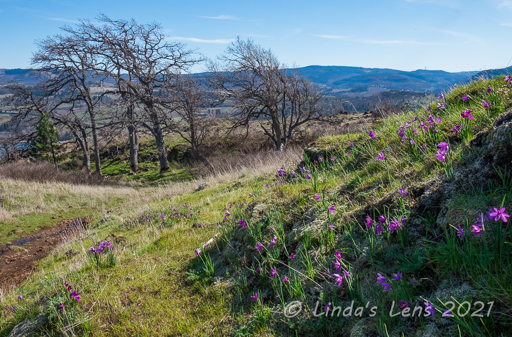
Wildflowers were still thick, even at higher elevations. Grass widows were everywhere, their lovely purple petals providing color to the hillsides. Desert Parsley, the other predominant plant in bloom, also lit up many slopes with bright patches of yellow.
 |
| More Mt Hood views |
Temperatures were beginning to rise and I sweated as I climbed up the winding Labyrinth trail. Although it was only two miles from the trailhead to the Atwood Road intersection, it seemed much longer. Finally glimpsing the trail sign, I was a very happy hiker.
 |
| Lone oak tree above the river |
Decision time - which direction should I go? East towards Catherine Creek or west towards Coyote Wall? Last year I'd hiked up Catherine Creek's most westerly trail to it's intersection with Atwood Road. Wanting to see what was in between last year's stopping point and my current location, I opted to head east.
 |
| I finally reach Atwood Road! |
Now on top of a ridge, my trail flattened out considerably and rolled along, dipping down through the woods into a drainage before emerging to a stunning Gorge viewpoint. It would've made a great lunch spot, but a group of ladies had already claimed it. So on I trekked, hoping to find an awesome vantage of my own.
 |
| Fantastic lunch spot |
After seeing few hikers on the Labyrinth, I ran into several large groups along Atwood Road. Every flat spot with views seemed to be claimed by people taking lunch breaks. Hungry, and now past noon, I kept on towards the Catherine Creek trail junction, hoping to find someplace to take a break. Reaching the Catherine Creek junction, I decided not to continue any farther east and instead retrace my steps back along Atwood Road. Lucky for me, I remembered the locations for most of the fantastic lunch viewpoints, and on my return trip came across one that was now unoccupied. Aaahh...finally! Lunch, rest, and a fabulous view was just what I needed!
 |
| Flower power |
Returning back to the Labyrinth- Atwood junction once again, I really wanted to make this more of a loop hike. So I decided to continue westward, in hopes of using one of the Coyote Wall trails to make a wide circle of the area.
 |
| Selfie spot |
My plan seemed to be working. I came upon another junction, this one with the "Old Ranch Road." Remembering this road from my Coyote Wall hikes, I knew it would get me downhill and back towards the Labyrinth. But the Coyote Wall trail system is popular with mountain bikers, and I began to encounter several people on bikes. All of the bikers I met were extremely courteous, and for my part, I made sure to step aside for them - especially when they were coming downhill (self preservation y'know!) But it was another hazard to be aware of that kept me on edge.
 |
| Hundreds of grass widows! |
Nearing the junction with the Little Maui Trail (that would eventually lead me back to the Labyrinth) I passed by an open slope absolutely covered with grass widows. Oh my goodness, there must have been hundreds, if not thousands, of these little purple blooms! Backlit by the afternoon sun, it was a stunning sight.
 |
| Purple spots everywhere |
My final path on this huge, wandering loop, the familiar Little Maui Trail, led me downhill towards the river. I was hiking this trail in reverse of the direction I had hiked it in the past. It was really fun and interesting to see the trail from a new angle. I noticed a few new things, and enjoyed seeing some of the familiar - a couple of great viewpoints, a grove of oaks, and a pretty burbling waterfall sandwiched between green fields dotted with desert parsley.
 |
| I couldn't believe the huge grass widow bloom |
And, still I found grass widows blooming in force! I think I picked the right week to enjoy peak bloom.
 |
| Looking down on the labyrinth and river |
The Little Maui Trail endlessly wound downhill. Going on 8 miles now, my feet and legs were getting mighty tired and the midafternoon heat stifling. I was ready to be done! Where was my final junction with the Labyrinth connector?
Finally coming upon the connector, I could see the first rocky promontory near the Labyrinth trailhead ahead. Yeah, almost done! I picked my way through this very rocky trail, stumbling a bit due to tired legs. Thankfully the connector was short, and before I knew it I'd arrived at the final junction before a short walk downhill to the road.
 |
| Waterfall from Little Maui Trail |
And then it happened. I'm not sure if I caught my foot on a rock, or if my tired legs dragging caused it, but suddenly I found myself falling. Seeing rocks coming towards my face, I threw my hands out to protect myself. Then a hard impact - and pain. Uh oh.......
I found myself on my back. Luckily it appeared my backpack had absorbed most of the fall. But from attempts to protect the face, my hands were scratched and bleeding. And my left wrist really hurt. Shakily I picked my body up, a bit embarrassed by my klutzy tumble. I shook arms and legs - nothing appeared to be broken. So I grabbed my poles and headed back to the car.
 |
| The end is in sight! |
By the time I arrived at the trailhead, my left wrist was throbbing. A mini mart stop for some ice and an empty sandwich bag provided an makeshift ice pack for the ride home. The following morning a trip to urgent care confirmed nothing was broken (luckily just a bad bruise to my left wrist).
Despite the unhappy ending, it was still a wonderful day in the Gorge exploring this new trail with the mysterious name. And it was a winner! I'll definitely be adding the Labyrinth to next year's spring hiking lineup.
Nearly 9 miles and 1800 feet total elevation gain for the day's impromptu loop.
***Note to my readers who follow this blog via email: I've been notified that the "Follow by Email" widget on my blog will no longer be supported after July 2021. I'll do some research to see if there's a replacement, but I'm not very hopeful of success. I do have a Facebook page, so if you're on Facebook I'd suggest you follow me there (link is on the sidebar).


Do glad you found and walked this trail. The scenery is so beautiful in fact breath taking Linda. The wildflowers are so pretty also and gorgeous waterfall. Have a good week ahead and stay safe.
ReplyDeleteHappy Mother's Day Linda!
ReplyDeleteBeautiful views, the wildflowers are gorgeous. I love seeing the views of the river and Mt Hood. What a wonderful hike, except for the fall! I am glad you were ok! Lovely series of photos. Happy Sunday, enjoy your day! Wishing you a great new week!
What a day with such beautiful sights and many good memories that far out weigh that fall. It is nice to see how you are living the life of retirement!
ReplyDeleteGoodness, I'm glad nothing is broken! It is amazing how many trails link up along that stretch of the river. You certainly lucked out with the flowers on this day!
ReplyDeleteWhat a great hike; you certainly got some excellent pictures. I hope the wrist soon recovers; I managed to fall over the other day and used my nose for a brake - it didn't look very pretty but no real damage done.
ReplyDeleteOh wow! All but the fall was so very beautiful . Those purple flowers are delicate and lovely and the views are magnificent
ReplyDeleteSorry about that klutzy ending, but looks like a great hike!
ReplyDeleteGood hike til the end. Glad you didn't get injured too badly. That's alot of miles to walk. Nice widow flowers. Not seen them. Columbia river gorge such a nice place to visit. Hope you had a good mother's day!
ReplyDeleteSo sorry to hear of your fall. So glad that no bones were broken.
ReplyDeleteA strenuous hike but oh my goodness, a snowy Mt Hood, stunning Columbia Gorge and multitiudes of glorious purple grass widows, what more could one ask for.