Tuesday, May 31, 2011

World of Waterfalls

The Eagle Creek Trail is my most favorite hike in the Columbia River Gorge.  Unfortunately, it's a lot of other people's favorite too.  On sunny summer weekends, Eagle Creek attracts huge amounts of visitors.  It's so popular the parking lot can fill up by 10 am, and the path is so jammed you feel like you're on a freeway.   That's why even though I love this trail, I don't hike it all that much.


Eagle Creek, near the trailhead

But last Friday, I had the day off.  I'd taken a vacation day in anticipation of a Memorial Day weekend camping trip.  A cold and rainy weather forecast forced Roger and I to cancel our plans.  Not wanting to waste a vacation day, I decided to go hiking.  Since it was a Friday, and the weather was kind of rainy, I decided to try the Eagle Creek trail.  I was hoping the wet weather, and the fact it was a weekday would keep people away.


Cool ferns in the forest

I decided it would be fun to try and get some good waterfall photos. So I packed up my camera gear and tripod. I also grabbed a pair of sandals. Spring means lots of high water, and I wanted to be prepared in case I had to wade into the creek to get some of my shots. Of course Bear saw me getting out my backpack, and stuck by my side like glue. There was no way he was letting me leave without him!


Fabulous trailside flowers

The wonderful thing about the Eagle Creek trail is the waterfalls. There are four major waterfalls, and in the spring, several other minor falls that thunder down the steep walls of this canyon. A short two-mile hike is all that is necessary to view Metlako and Punchbowl Falls. At mile four, Loowit Falls is visible. And if one follows the path six miles, they'll be rewarded with a grand view of Tunnel Falls - the best waterfall of them all.


There are cable handrails along the trail

The Eagle Creek Trail was constructed in 1910 to coincide with the opening of the Columbia River Highway.  The trail is something of an engineering marvel.  To keep a fairly flat grade through the steep canyon, the builders blasted ledges into the sides of sheer cliffs.  They bridged a deep narrow gorge, and chipped a tunnel behind Tunnel Falls (hence the waterfall's name!)  The parts of the path along the cliff have steep dropoffs, so cables were installed as handrails.


To protect you from dropoffs like this

There are times as I'm crossing these cliffy areas, I grab onto those cables and am very glad to have them.  Some parts of the trail have steep dropoffs, and if you fall, it wouldn't be pretty!


And this

Bear and I started out from the trailhead, and didn't get very far, when I became distracted by the beautiful trailside wildflowers.  Well, I'd brought my camera for a reason, and wasn't going to waste all this nice scenery without capturing it! 


Bear is posing for me

Progress was slow, as per usual, with me clicking away at the wonderful sights.  It had been a couple of years since I'd hiked this trail, and I remembered why I love this place so much.  Eagle Creek is jaw-dropping-ly beautiful.  There are huge lichen-draped old-growth trees hugging the sides of the trail, steep mossy cliffs, many sporting small impromptu waterfalls, and this time of the year, lots of colorful wildflowers.  Eagle Creek roared in the gorge below, sometimes very far down.


The creek is waay down there

I ran into a nice couple visiting from Florida who were just blown away by the scenery.  I got to play tour guide and gave them lots of info about the great places to visit in the area.  We leapfrogged by each other several times on the trail, usually when I stopped for a Kodak moment.


Metlako Falls

I finally arrived at Metlako Falls, the first waterfall on the trail.  The recent rains had this falls gushing mightily. You can't get real close to Metlako Falls.  It's only visible from a viewing area that juts out over the side of the canyon wall.  I straddled my tripod over a cable fence on the edge of the drop off.  There were some pretty pink flowers in the foreground I was trying to include in my shots, and this position was the only way I could capture them.  I didn't get too daring, but did succeed in getting some images I liked.


Bear patiently waits for me to finish my photos

As I was finishing up my photo session at Metlako Falls, a couple of young men came down the trail armed with cameras and tripods.  We exchanged hellos, and I found out one of the men is a prolific photographer and poster on Flickr.  I've seen lots of his work, and it is excellent.  It's always nice to run into fellow photographers who are as excited about shooting images as I am.
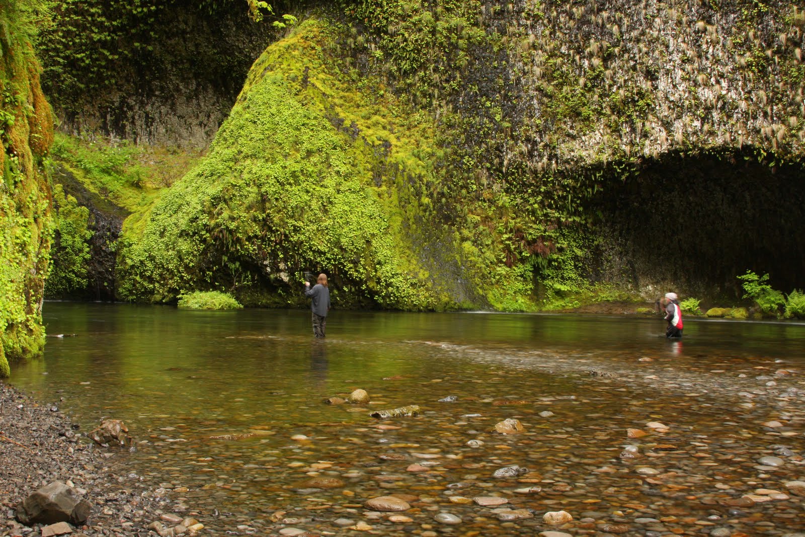

Punchbowl Falls

After Metlako Falls, it was only a short distance to reach the turn off for Punchbowl Falls.  A short, steep path takes one down the canyon to the rocky bank of Eagle Creek.  From there, it's a short walk to the viewpoint.  Or, at least during low water there's a dry viewpoint.  Today the water was so high that the only way to see the falls was to wade out into the creek.  Good thing I brought my sandals!


Punchbowl Falls in its green mossy grotto

Punchbowl Falls is a cute little waterfall situated in a round mossy grotto that resembles a punchbowl (another original name!).  The waterfall is in such a pretty setting, it's popular with photographers, and many images of this waterfall appear in calendars and books.

I changed into my sandals, and waded into the creek to capture my own images.  The water was freezing cold, and the rocks really slippery.  I almost went down once (which would have been really bad, because not only myself but my camera would have gotten wet).  I waded out as deep as I dared and set up my tripod.  I fired away, trying to collect as many shots as I could before my feet went totally numb.


I had to wade out into the creek like these guys to get my shots

When I couldn't stand the cold water any longer, I slowly waded back to shore.  As I was making my way out of the creek, I noticed the two young men I'd met at Metlako Falls on the river bank.  They were preparing to enter the water.  As I splashed out of the creek, I told them "It's all yours!"


Small creeklet

Not long after I was back on shore, the skies opened up and it began to pour.  Luckily, I had most of my camera gear packed away before it got too wet.  I was glad to be out of the water.  I wouldn't want to be stuck out in the middle of that creek in a downpour!  I left the guys in the water, their cameras clicking away.  I'm curious what kind of photos the guys captured, so I'll have to check the Flickr site and compare.  Despite the rain, I'm sure they got some really good ones.


Round a bend in the trail

I continued down the trail, planning to reach the next waterfall.  But the rain continued, and I began to get really wet and cold.  I decided to turn around at high bridge, about mile 3.5. 


Wildlife sighting near the trailhead

As I retraced my steps back to the trailhead, the rain began to subside and I enjoyed my return trip.  This is one trail I don't mind hiking twice.  Just as I was nearing the end, I looked across the creek and there on the opposite bank was a doe.  She was munching away on vegetation, totally oblivious to Bear and I.  I took out my camera.  That must've got the doe's attention, because she turned around and looked straight at me.  It was as if she struck a pose solely for my camera.  I fired off a few shots, but my autofocus didn't want to cooperate, so this was the best I was able to do.

Bear and I toweled off at the car, and I got to experience the wonderful aroma of wet dog all the way back to Portland.  Although the rain forced me to turn around prematurely, I still had a great day.  I got to visit some lovely waterfalls and hike one of my favorite trails.  Next time, I'm going all the way to Tunnel Falls and beyond.  I've got the waterfall bug now!


Thursday, May 26, 2011

Return to Angel's Rest

Since I didn't do any "real" hiking during last weekend's coast exploration, I was more than ready to climb up some trail in the Gorge.  I wanted to choose a hike that had lots of wildflowers. This time last year the Angel's Rest Trail was sporting a beautiful bloom of larkspur flowers.  I decided to go check out this year's crop.

 
Little purple larkspur

The wildflowers of Angel's Rest did not disappoint.  I got my first larkspur sighting next to the trailhead sign.  From there, it just kept getting better. 


My happy pup!

Not too far down the trail, I ran into a huge purple mass of larkspur blooms lining both sides of the trail.  Forward progress ground to a halt, as my camera came out.  I spent at least 20 minutes shooting photos of the beautiful flowers. 


The flowers look like little purple birds

Bear started getting antsy, so I finally turned off my camera and continued the hike.  But we hadn't gone much farther when I encountered another huge mass of trailside flowers, this one even better than the first.


Gobs of purple flowers brighten the forest

I had no choice but to stop and take more photos.  There was so much larkspur blooming that it colored the sides of the trail purple.  I think this display was even better than last year's bloom!


Purple spot

I spent way too much time photographing at the second spot, and finally had to tear myself away.  If I kept this up, I was never going to get my hike in!


Looking west down the Gorge

I huffed and puffed up the steep trail, occasionally stopping for a water or photo break.  I began to get glimpses of the Columbia River through the trees.  Then I crossed a rockslide, and knew I was getting close.


Gnarled tree at the top

I've hiked Angel's Rest many times, and know where the good view spots are located.  When I reached the top, I bypassed the large rocks where most people stop, and headed for the bench.


Bear and I taking a breather on Angel's Rest

There's a sturdy wood park bench that sits near the edge of the Angel's Rest cliffs.  This bench is located in a very scenic place.  You can look east and west down the Gorge for fabulous views of the Columbia River.  I was lucky and found the bench unoccupied.  I claimed my spot, dug out some snacks, and had myself a nice break.  Although the skies were overcast, the Gorge panorama before me a was mighty fine sight.


Time to check out Devil's Rest

The Angel's Rest trail is a nice hike, but for me it's too short.  Whenever I'm hiking this trail, I always try to tack on a few additional miles.  Today I decided to try and hit Devil's Rest, and to make a loop, return on the Wahkeena Trail.  I've hiked to Devil's Rest a few times, but I've always approached from the Wahkeena Trail.  This time I'd be hiking to Devil's Rest from the opposite direction.


Pink flowers brighten the forest

I followed signs and trails, almost got lost once (and was saved by my gps) but finally arrived at the large rockpile in the forest that is Devil's Rest.  It's kind of a disappointing place - no views, just a bunch of huge, mossy boulders.  But it was past lunchtime, and I was hungry, so it looked like a great place to stop and nosh.


Lots of trilliums in the higher elevations

When I arrived, there was a couple already sitting amongst the rocks of Devil's rest.  We said our hellos, and I then busied myself with recharging my body's energy supply.  When I looked over at my neighbors again, they were deep in a long kiss.  Embarrassed, I turned away from their private moment.  Many minutes passed, and when I dared to look again, they were still smooching away.  The couple stayed lip-locked for at least ten minutes longer.  Uncomfortable to be intruding on such an intimate moment, I scarfed my lunch down, and headed back to the trail.


The cliffs of Angel's Rest

I headed down the Wahkeena Trail.  After climbing for most of the day, it was nice to let gravity do some of the work.  But sadly, what comes down must go back up, and to get back to Angel's Rest, I had to do more climbing!  Luckily, there were lots of pretty wildflowers to distract me from my slog.  And occasional photo breaks to give me some quick rest!


The trail home!

Finally the steep cliffs of Angel's Rest came back into view.  It was all downhill from here!  I was getting tired and footsore, so it was a welcome sight.  As I traveled back down the trail, I met tons of people hiking up.  Angel's Rest is a very popular hike, and on nice weekends attracts lots of people.  I was glad to have started early and avoided the crowds.

Although I didn't get any sun today, I also didn't get any rain.  The way this spring's going, I'll take the dry day!  Total stats for this hike:  10 miles, at least 2400' elevation gain to Devil's rest, and probably another 500' on the Wahkeena Trail.  Enough to get me tired and sore, satisfy my yearning for a hike, and give me lots of wildflower photos.


Monday, May 23, 2011

Cape Disappointment

Last weekend, I had a whole two days entirely to myself.  Roger was in China, and Cody was visiting friends in Montana.  What to do?  So many possibilities!  Since I always find myself heading east towards the mountains or the Gorge, I decided to mix things up a bit and head west.  Even though I live an hour's drive from the coast, I hardly ever go there.  I was overdue for a visit.  It was high time to explore the ocean beaches!


North Head Lighthouse

A coworker told me about the Long Beach Peninsula of the Washington Coast.  He said it was out of the way just enough to discourage the crowds of people that usually swarm to the Oregon beaches.  In all the years I've lived in the northwest, this was one place I'd never been.  So on Saturday, I packed up the dog in the car, and headed west to check it out.


Looking out towards the sea

The Long Beach Peninsula is located on the very southern Washington coast, just across the Columbia River from Astoria, Oregon.  The peninsula itself is a 28-mile long strip of wave-packed sand.  On the very south end of this feature lie the rocky headlands of Cape Disappointment.  Cape Disappointment is a cliff-edged promontory located at the point where the Columbia River meets the Pacific Ocean.  It was named in 1788 by English explorer Captain John Meares, who in seeking the Columbia River wrote of missing the passage over the bar, and in his discouragement named the nearby headland Cape Disappointment.


The weather-beaten lighthouse walls

This area is rich in history.  Lewis and Clark arrived at Cape Disappointment in November 1805 and noted in their journals their astonishment at the high waves dashing against the rocks.  Later, when ships began to visit the area, the high waves and treacherous river bar created what seaman came to call "The Graveyard of the Pacific" at the mouth of the Columbia.  Hundreds of ships and lives were lost at sea here.  To protect the mouth of the Columbia River from enemies, a fort was established on Cape Disappointment in 1862.


Auxiliary buildings on the lighthouse grounds

So off I drove, excited to explore a new locale.  I felt a little like Lewis and Clark - except instead of a canoe, I had a Subaru!  I waded through Saturday traffic on Hwy 101 between Seaside and Astoria.  And then, up ahead, I spied the Astoria Bridge.  This bridge spans the mouth of the Columbia River, and is four miles in length.  To allow for ships to pass underneath, the bridge rises up dramatically on the Astoria side, to provide 196 feet of clearance at high tide.  Once past the designated shipping channel, the bridge dives back down closer to the waters of the river.  It's quite an impressive structure, and one I had never crossed - until today!


Ocean view below the lighthouse

I have to admit, I was a little bit nervous as I drove up the structure's circular entrance ramp.  That bridge was really high up!  On the very top, I couldn't make myself look over the side, and instead just concentrated my gaze straight ahead.  After passing the high point, the pavement dived back down rather steeply, and the engineer in me wondered "what is the grade of this road?"  Once safely on the lower portion of the bridge, I was able to relax and take in the scenery around me.  But all I could see was water - and lots of it.


If these walls could talk...

I finally made it to the other side of the river, and followed the signs through the town of Ilwaco to Cape Disappointment State Park.  The first stop on my tour was the North Head Lighthouse.

The North Head Lighthouse went into operation on May 16, 1898.  A lighthouse constructed earlier on Cape Disappointment was not enough to prevent shipwrecks.  Ships traveling from the north could not see Cape Disappointment's light, so this lighthouse was built two miles to the north. 


Lighthouse keepers homes - nicely restored

I love visiting and photographing lighthouses, and was pleased with North Head.  It had a cute white tower with a red top.  The building was situated on a dramatic headland that jutted out into the sea.  It was a cloudy day, so the views weren't as nice, but it was still mighty impressive.  I chatted briefly with a very friendly woman volunteer, who offered to hold Bear's leash if I wanted to go inside and look around.  I declined, and instead roamed around the grounds shooting tons of photos. 

Love the top sign!

That day happened to be the 113th birthday celebration of the North Head lighthouse.  Back at the gift shop, a group dedicated to preserving the lighthouse was holding a party, complete with cake and punch.  The group was trying to raise money to preserve the lighthouse, which was looking rather worn and weather-beaten.  However, the nearby lighthouse keeper's homes seemed to be in excellent repair.  I was curious why these buildings looked so good while the lighthouse was so shabby. One of the volunteers explained that the keeper's houses are used as vacation rentals.  What a great idea - those homes would be a cool place to spend a weekend!


Dead Man's Cove

After getting my lighthouse fix at North Head, I was ready to see more.  I drove south and decided to check out the other lighthouse at Cape Disappointment.  From the parking lot, a short but steep trail took me up to the rocky headland.  On the way, I passed by a narrow inlet named "Dead Man's Cove."  Sounds like something you'd see in a pirate movie doesn't it?  Apparently this cove was named after casualties from a shipwreck washed ashore on its beaches.


Cape Disappointment Lighthouse

Bear and I trudged up the final hill to the Cape Disappointment lighthouse.  And I hate to say it, but this lighthouse was, well - a disappointment.  There were a bunch of ugly radio towers next to the building.  There wasn't much room to walk around at the base, so it was hard to get photographs of the entire scene.  The lighthouse tower itself was not open to the public, so all I could do was peek through the windows.  There were no volunteers on hand to answer questions.  And the lighthouse itself was not as pretty as the one at North Head.


View towards the mouth of the Columbia River

So I didn't linger long at Cape Disappointment.  I shot a couple of photos, and took in the views.  The one nice view was looking south towards the mouth of the Columbia River and the jetties.  Such an enormously wide body of water!  I can't believe that Lewis and Clark crossed it using only canoes.


Busted sand fence at Benson Beach

Bear had been a very patient doggie, following me around on my lighthouse explorations.  But he was getting antsy, and needed to romp on a wide, sandy beach.  We jumped back in the car, in search of such an area.  I followed the signs to Benson Beach, arriving at a sand-drifted parking lot.  Bear happily bounded out, frisbee in his mouth.  We walked through the sand dunes onto a deserted beach.  Broken sand fences and driftwood littered the area.  It wasn't a very pretty place, but to Bear it was wonderful.


Time for frisbee!

I tossed the frisbee into the wind, and Bear ran and ran.  The soft sand was difficult to run through, and it didn't take long before Bear was tuckered out.  I shot a few photos of the dunes and the broken fences, but the dreary cloudy light didn't make for spectacular conditions.  We headed back to the car, where I dumped a ton of sand out of my shoes, and brushed off Bear as best I could.  Bear curled up in the back of my car, ready for a snooze on the ride home.


Cape Disappointment from the beach

Before I pointed my car towards home, I made one final stop at Waikiki Beach.  From the beach was a great view the Cape Disappointment lighthouse, perched atop its headland.  I shot some photos of the rocky cliffs with the green hillsides.  I wish it would've been a sunny day for better photos, but today I had to take what I could get.  This photo doesn't do justice to such a wonderful scene.

Although I didn't see any nice beaches, it was still fun to tour a couple of lighthouses, and learn a little history.  It was a nice change of scenery to visit the ocean instead of the mountains.  I've "discovered" a new place on the Washington coast!

:)

Friday, May 20, 2011

Flower-o-rama

Spring is a beautiful season here in Portland.  Beginning in early March continuing through June, flowers abound.  The bloom progresses depending upon tree and plant species, so that there is always something flowering throughout the spring. 

 
Rhodies in our front yard

Around early March, the cherry trees start things out.  Delicate pink blossoms can be found everywhere.  Daffodils push slender stalks out of the soil, and display their glorious golden yellow flowers.


Light pink rhodies

In April, colorful tulips pop up everywhere.  The rhododendron bushes start to bloom.  The flowering pear tree in our front yard bursts into frilly white blossoms.


Our lone tulip

April also brings buds on the trees.  New leaves burst from their branches in neon-bright shades of green.  After a gray, rainy winter, it is a welcome sight.


Our neighbor's yard has these cute bleeding heart flowers

April brings blossoms on the fruit trees.  Our backyard apple trees sport lovely white flowers and rosy pink buds.


Flowers on our apple tree

Then in May come the multi-colored azalea blooms and, my favorite of all, the dogwood trees.


Pink dogwood blossoms

The dogwood trees open up with their lovely pink and white flowers.  Dogwood trees can be seen flowering all over town.  Dogwood blooms are so wonderful to see as I'm driving or walking along the street.


White dogwood flowers reach for the sky

Although we don't have a dogwood tree in our yard, there are several in our neighborhood.  I've even spied dogwood trees growing wild in the Gorge, and along the freeway.


Isn't this the most beautiful flower?

So if you live in Portland, enjoy the season.  Flowers are our reward for enduring the winter's endless rains (especially this year!).   After so many dark, dreary days, we've earned it!