
I've created a new page for the new year to record all my hikes for 2025.
-----------------------------------------------------------------------------------------------------------------------------
Hike No. 1 - 1/8/25 - Gales Creek and Storey Burn Trails, Oregon Coast range. First hike of 2025! I joined friends Debbie and Barry for a nice stroll on a favorite loop trail that I hadn't hiked for a couple of years. It was a dry, partly sunny day - welcome weather after so many rainy days. We encountered some blow-down but it wasn't insurmountable. We were surprised to see the last segment of our loop, the Gravelle Brothers trail, had been rerouted to higher ground. More climbing at the end of a hike that wasn't welcome at all! But we survived. 8.6 miles, 1800 feet elevation gain.

Hike No. 2 - 1/19/25 - Hamilton Mtn loop, Columbia River Gorge, Washington. It was a sunny, but cold day. Taking advantage of the dry weather, I convinced my hubby to join me for a trek up Hamilton Mtn. Despite the cold, the uphill slog soon warmed us both! There were some great views from the saddle, even saw the tip of Mt. Hood. Great exercise, and it felt good to be outdoors. 8 miles, 2500 feet elevation gain.

Hike No. 3 - 1/26/25 - Wilson River Trail, from Jones Creek Trailhead to Wilson Falls, Oregon Coast range. My friend Catherine invited me to join her family on a hike along this lovely riverside trail. It was a chilly but sunny day as we set out from the trailhead. The mossy coast range forest is always a treat to hike through. And the blue-green waters of the Wilson River make a nice place to sit beside for a lunch break. 5.5 miles, 600 feet elevation gain.

Hike No. 4 - 1/29/25 - Various trails in Stub Stewart State Park, Oregon Coast range. After over 2 weeks of cold, sunny weather (unheard of in January!) today was supposed to be the last day of this break from the usual gloom. Taking advantage of this final sunny day, I decided to get in a quick hike at the closest state park to home. I discovered there's a lot of logging (thinning, they claim) of trees going on right now, so there was hardly anyone in the park. But I had a nice romp through frosty forests and frozen mud, past an icy Boomscooter pond. 6 miles, 1000 feet elevation gain.

Hike No. 5 - 3/1/25 - Gnat Creek Trail, Oregon Coast Range. Yeah, it's been over a month since I've hiked....been too busy skiing. But today's beautiful warm weather was perfect for a romp in the woods. I introduced friends Debbie and Barry to this lovely trail that winds through moss-covered forests following a charming creek. This time we made it all the way to the trail's end (two years ago a landslide prevented access to the terminus.) Birds were singing and the air felt almost muggy. Spring is on its way. 8.1 miles, 1000 feet elevation gain.

Hike No. 6 - 3/7/25 - Catherine Creek, Columbia River Gorge, Washington. When the grass widow flowers begin to bloom, I know it's time to start my spring wildflower hikes. And this year's crop at Catherine Creek were plentiful. I made a visit to the paved path adjacent to the river, and then crossed the road and climbed uphill for a quick loop. It was a lovely sunny day, perfect for wildflower viewing. 4 miles, 900 feet elevation gain.

Hike No. 7 - 3/24/25 - The Labyrinth trail, Columbia River Gorge, Washington. Wildflower season is underway in the eastern gorge, and friends Debbie and Barry invited me to join them to check out the bloom. The Labyrinth is one of my favorite spring wildflower trails and today it didn't disappoint! However, we encountered some unexpected rainy and foggy weather for the first two hours of the morning before the skies cleared to lovely sunshine. Grass widows and desert parsley were prolific, and I spotted my first balsamroot blooms of the year! 7.4 miles, 1800 feet elevation gain.

Hike No. 8 - 4/16/25 - Memaloose Hills, Columbia River Gorge, Oregon. I've been logging lots of ski days this year, but when I heard the Gorge wildflowers were blooming, I took a break from the slopes to check things out. This area is one of my favorites for spring wildflowers, and lucky me I hit it at peak bloom! Chatfield Hill was absolutely stunning, and I arrived early enough in the morning to have the place to myself the entire time. Marsh Hill was nice too, and I stumbled upon a "new to me" loop trail wandering through lovely oak woods from its summit. I think it's time to stow the skis for my hiking boots and camera! 3.5 miles, 500 feet elevation gain.

Hike No. 9 - 4/18/25 - Tom McCall Point and Mosier Plateau, Columbia River Gorge, Oregon. I just couldn't get enough of the Gorge spring wildflowers, so two days later I was back with friends Debbie and Barry. We hiked up Tom McCall Point and soaked in the colorful beauty of its slopes. Then, after a quick lunch at Mosier's famous taco truck, we did a quick climb up to Mosier Plateau. It was a warm day and the afternoon climb in the heat wasn't fun. But our reward was more lovely wildflower meadows and killer Gorge views. About 5 miles between the two trails and at least 1000 feet of elevation gain.

Hike No. 10 - 4/21/25 - Crawford Oaks Loop, Columbia Hills State Park, Washington. Back to the Eastern Gorge I went for the third time in a week. When it's wildflower season, I go! This time it was to take in the spectacular wildflower bloom at the Dalles Mtn Ranch (ie Columbia Hills State Park.) My hubby joined me for the trek and it was fun to show him this outstanding wildflower paradise. We started our hike super early, and enjoyed being serenaded by several meadowlarks. Not many people at this early hour and it was nice to have a usually busy trail mostly to ourselves. And the lupine bloom was the best I've seen. It was really windy and cold but better than hot temps in my book. 7.5 miles, 1050 feet elevation gain.

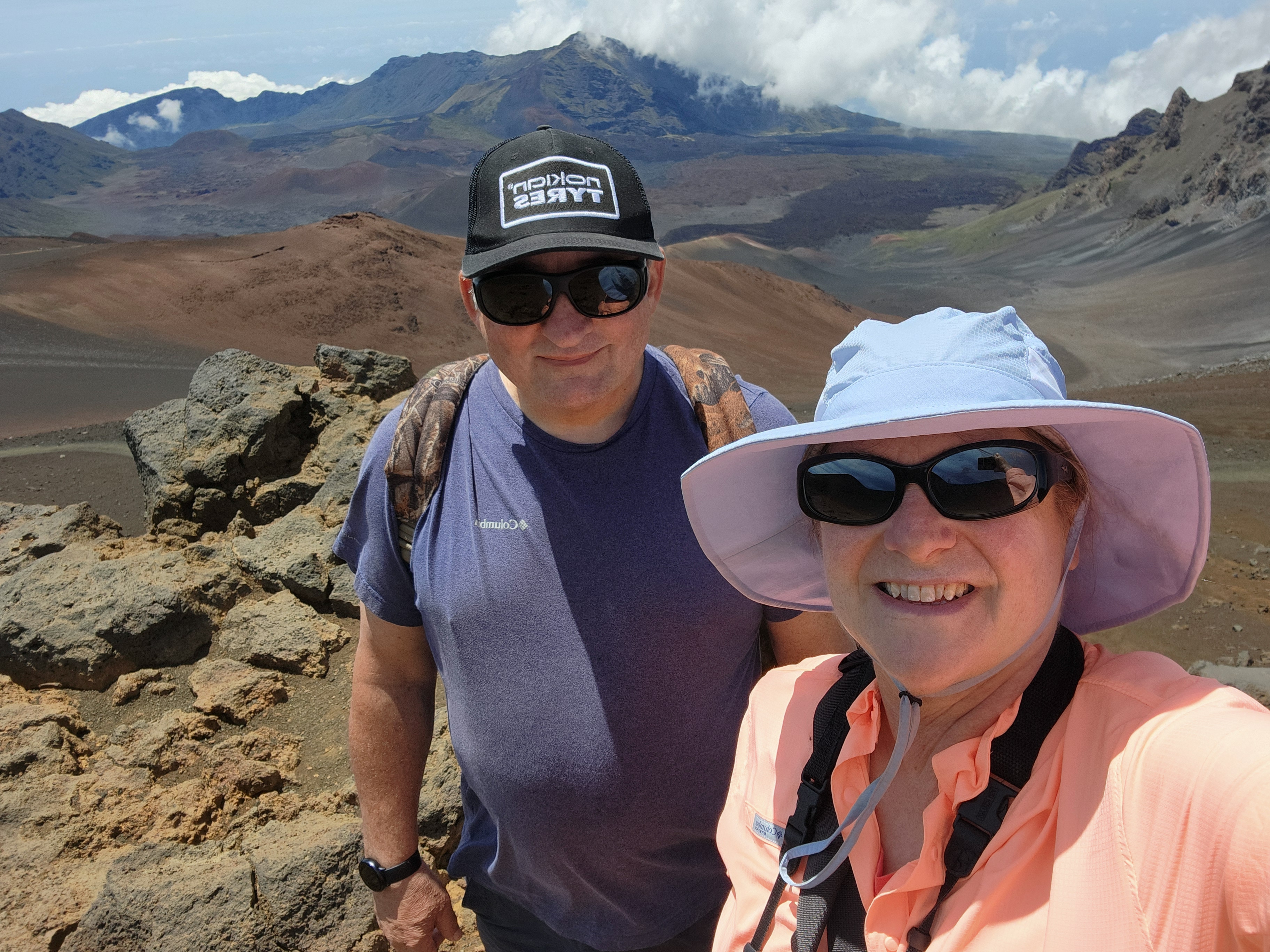
Hike No. 11 - 4/24/25 - Sliding Sands Trail, Haleakalā National Park, Hawaii. I've just returned from a fabulous trip to Maui (blog posts coming!) While visiting my hubby and I took two short hikes in Haleakalā National Park. The first was a 2 mile out-and-back down the sliding sands trail into the volcano crater. The second was a bird watching loop around Hosmer Grove. We saw the beautiful bright red 'I'iwi bird and one greenish Kiwikiu bird. I'd hoped to also spot a Hawaiian short-eared owl (one volunteer said there were "tons of them in the parking lot") but they must've taken that day off because I didn't see any. Still it was a great day and I got to check another National Park off my list!
Hike No. 12 - 4/30/25 - Boundary Trail, Hummocks Trailhead to just below Johnston Ridge, Mt. St. Helens NVM, Washington. Ugh, this hike is really hard to write about......I'd been wanting to get up to MSH in hopes of photographing the mountain goats that live there. So I made the long drive and hiked the 4 uphill miles to where they hang out. It was a foggy morning, but the clouds soon lifted. Just below Johnston Ridge Observatory the trail traverses a steep slope. It was here I spotted a herd of goats running. Excited, I took off my backpack, placed it on the trail, and dug out my zoom lens. I'd no sooner taken my lens out when my backpack tipped over and began rolling down the steep slope below the trail. I had my hands full of camera and lens and wasn't able to grab it. I watched in horror as my backpack hit a large rock and disappeared from sight. My wallet, cell phone, prescription sunglasses, and expensive Garmin GPS were in this backpack. What to do? I considered climbing down the slope to look for it, but the slope was full of loose soil and rock. It didn't look safe at all - and I was by myself. I sat there for a long time in shock before realizing there was nothing I could do. I sadly hiked all the way back to my car (luckily the keys were in my pants pocket!) 9-ish miles, 2000 feet elevation gain. The worst hike of my life....

Hike No. 13 - 5/1/25 - Boundary Trail again in search of my lost backpack. When he learned what happened, my hubby wanted to go back and look for my backpack. So the very next day we drove all the way back out to MSH and hiked the 4 uphill miles to the place where it rolled down into the steep ravine. Since it was way too steep to climb down where the backpack was lost, my hubby tried accessing the ravine via a gentler slope a quarter mile away. He was gone for 2 long, anxious hours before returning, totally exhausted. Although not successful, returning to the scene of the incident did bring some closure and made me realize I'd done the right thing by not going after my backpack. No photographs from this hike, I didn't even bring my camera. (Side note - replacing everything I lost was a total nightmare!)
Hike No. 14 - 5/22/25 - Stub Stewart State Park, Oregon Coast Range. After a trip back east to visit my parents I was more than ready for a hike. It was also a shakedown to try out all the new gear I had to purchase to replace what was lost when my backpack tumbled into a ravine. I saw no other hikers the entire time, but I did see a pygmy owl! After so much strife and bad luck recently, this sighting really made my day. 5 miles, probably 800 feet elevation gain.

Hike No. 15 - 5/24/25 - Bayocean Spit, Oregon Coast. I joined friends Debbie and Barry for a jaunt around lovely Bayocean Spit, located between the Pacific Ocean and Tillamook Bay. We spotted lots of sparrows, shorebirds, orange-crowned warblers and a rufous hummingbird. Sadly, work on the jetty meant we had to cut our hike a bit short. It was a beautiful day, sunny but not too hot or windy. 5.2 miles, 200 feet elevation gain.

Hike No. 16 - 5/26/25 - Hardy Ridge, to Upper Trail junction, Columbia River Gorge, Washington. Time for another hike! This time I recruited Catherine to join me for a close to home ramble. Wildflowers were blooming and the forest was a bright shade of new leaf green. It was great to catch up with my friend, and test out my new Garmin inreach mini (I still miss my old 66i Garmin!) We were both in the rebuilding stages of our fitness, so turned around at the upper trail junction. Logged about 7 miles and 1900 feet elevation gain (I think - still getting used to my new gps!)

Hike No. 17 - 6/18/25 - PCT north and south from Lolo Pass, Mt. Hood NF, Oregon. Home from over two weeks in Scandinavia, I hurried out to capture the peak beargrass bloom on Mt. Hood before it was over. The rhodies were also flowering, so I chose to hike from Lolo Pass to capture the abundance of both. It was a fine choice - first I took the PCT heading south, knowing from past years that the rhododendrons bloomed prolifically in the first mile. Then I did an about-face and headed northbound to capture an insane beargrass bloom under a clearing for some large electrical transmission towers. 3.2 miles, 700 feet elevation gain, a short but sweet hike!

Hike No. 18 - 6/20/25 - Wolf Tree and River Trails, Smith Rock State Park, Oregon. Hubby and I made a trip over the mountains to visit our daughter in Central Oregon. While she was at work, we took a hike in nearby Smith Rock State Park. First, Hubby and I explored the Wolf Tree Trail. Some wildflowers were still blooming, and we spotted a couple of deer. Then we followed the Crooked River in the opposite direction along the River Trail. It was a thankfully cooler day, and the strong winds, although annoying, kept the temperature comfortable. 4.2 miles, 700 feet elevation gain.

Hike No. 19 - 6/24/25 - Mirror Lake to Tom, Dick and Harry Mountain, Mt. Hood NF, Oregon. I'd heard the rhododendron bloom was going strong along this trail, so still fighting a bit of jet lag, I rose early and decided to see it for myself. The rumors were true - this trail was lined with lots of lovely pink blossoms. The beargrass was also putting on a show. I encountered a large group of firefighters who'd just completed their training, both on the way up and down, and also at the top of Tom, Dick and Harry Mountain. On the way back I stopped by Mirror Lake to capture the money shot of Mt. Hood reflected in its waters. A good day to tromp around in the mountains! 8.3 miles, 2,200 feet elevation gain.

Hike No. 20 - 6/26/25 - Larch Mountain Crater Loop, Columbia River Gorge, Oregon. I reconnected with friends Debbie and Barry for a trek around this beautiful, but surprisingly not busy, trail in the Gorge. The morning began overcast and a bit foggy at the trailhead. But that was okay, as it kept temperatures delightfully cool. Rhododendrons and beargrass were still blooming, and I was happy to see more of these unique early summer blooms. This trail passed through some gorgeous old growth forest and the vine maple leaves were a dazzling shade of new spring green. 7 miles, 1300 feet elevation gain.

Hike No. 21 - 6/28/25 - Boundary Trail, from Hummocks TH to Johnston Ridge Observatory, Mt. St. Helen, NVM, Washington. Yes....I returned to the trail of infamy......the trail where I'd lost my backpack two months earlier. It wasn't my idea. Hubby wanted one more try to scan the slopes below for any sign of my belongings. So, reluctantly I agreed to go along (mostly to keep my hubby from doing anything dangerous.) It was a foggy, cool morning and although the conditions kept us from seeing the mountain, it did make the steep climb much more bearable. A huge bright spot - wildflowers were blooming. Hubby took his binoculars and thoroughly looked over the area my backpack went down but no luck. However, we had a nice lunch at JRO, and the mountain eventually emerged from her foggy curtain. I think this hike gave both of us closure on the loss of my stuff. Time to move on. 10 miles, 2000 feet elevation gain.

Hike No. 22 - 7/1/25 - Iron Mountain/Cone Peak Loop, Willamette National Forest, Central Oregon. Hubby and I were camping at nearby Clear Lake, and I wanted to revisit this wildflower-rich trail. It had been awhile since my last hike here. The wildflowers were just past peak, but we still found lots of yellow Oregon sunshine and stonecrop blooming. And the butterflies were out in force, so I had fun trying to photograph them. We opted to take the side trip to the top of Iron Mountain and I'd forgotten what a steep slog it is! Oh, and did I mention the weather was brutally hot that day? We survived and were rewarded with an amazing wildflower show near the top for our efforts. 7 miles, 1700 feet elevation gain.

Hike No. 23 - 7/5/25 - Various trails around Mt. Hood Meadows, Mt. Hood NF, Oregon. It was stop number four in the summer beargrass superbloom tour! I'd heard the Umbrella Falls trail had beargrass blooming in abundance so had to check it out. The rumors were true! Not only beargrass, but other wildflowers were also adding color to the surroundings. After hiking the Umbrella Falls loop, I headed to Mt. Hood Meadows and hiked a bit of the trails in the resort. I found lots more beargrass and other wildflowers. It was a great day of wildflower photography and I'll be back to see more! 7 miles total between the two trails and 1750 feet elevation gain.

Hike No. 24 - 7/10/25 - Umbrella Falls and Timberline Trails, Mt. Hood Meadows ski area, Oregon. I just couldn't get enough of the wildflower show at Meadows, so I got Kim to join me a few days later. It was just as wonderful as it had been five days earlier. The beargrass was insane under the Mt. Hood Express lift, as was the paintbrush and lupine. We spend lots of time photographing and admiring all the beauty. A stellar day to hike on Mt. Hood! Later, over lunch and beers on the ski area's patio, I remarked to Kim that this was my favorite place on the mountain - I have good memories here winter and summer. 5 miles, 800 feet elevation gain.

Hike No. 25 - 7/226/25 - Stub Stewart State Park, Oregon Coast Range. Back from another SD trip I needed some exercise badly, so drove over to my local standby, Stub Stewart. Although I was hoping for a repeat pygmy owl sighting, I didn't hear one hoot. I did however, hear another larger owl, but couldn't locate it. Not many photo opportunities, but I did capture a cute little gray bird near the parking lot. 5 miles, 900 feet elevation gain.

Hike No 26 - 7/27/25 - Various trails around Mt. Hood Meadows, Mt. Hood NF, Oregon. After being gone for nearly two weeks, I was curious to check out the bloom around MHM, so recruited Catherine and her daughter to join me. Right away I got stung in the face by some sort of wasp. Then I slid into a small creek trying to cross it (just got wet feet and a skinned knee.) But the flowers were great - especially in Heather Canyon. There was a 100-mile race going on and we spotted a few runners on the trails. Good day to be outside! 7 miles, 1250 feet elevation gain.

Hike No. 27 - 7/31/25 - Trails around Mt. Hood Meadows, Mt. Hood NF, Oregon. I just couldn't get enough of the fantastic wildflowers, so I headed back to Meadows for more! This time I was accompanied by Debbie, Barry and my hubby. It was a cloudy, humid day but the diffused light made for good photography. Another 7 mile, 1200 feet hike!

Hike No. 28 - 8/5/25 - McNeil Point, Mt. Hood NF, Oregon. It's a tradition - when the wildflowers bloom on Mt. Hood's west side, I make my annual trek up to McNeil Point. Catherine and I recreated last year's hike - and the wildflowers were in good form, although not as abundant as last year's superbloom. Temperatures were cooler which made the climb much more bearable. Seeing the tumble-down stone shelter is like revisiting an old friend. 10.5 miles, 2800 feet elevation gain.

Hike No. 29 - 8/7/25 - Tilly Jane Ski Trail to Timberline Trail and Cooper Spur Shelter, Mt Hood NF, Oregon. This trail usually has good summer wildflowers, so I recruited Debbie and Barry to join me for a shakedown hike. The good news - today's weather was cool so it made the long climb bearable. The bad news - most of the flowers were past peak, what few blooms there were. And I'd forgotten what an uphill slog it is from Cloud Cap to the Cooper Spur turnoff on the Timberline Trail. But my friends enjoyed this "new to them" hike and it was a good, although challenging day. 9 miles, 3000 feet elevation gain.
 |
| Two stone shelters visited in a week! |
Hike No. 30 - 8/14/25 - Paradise Park loop, Mt Hood, Oregon. I have a love/hate relationship with this trail. Paradise Park's wildflower fields are some of the best on Mt. Hood. However, reaching this lovely spot on the mountain requires a long, arduous trek of 13.5 miles, with the final 3.5 miles all uphill. I hemmed and hawed several days before finally making the decision to just go for it. And the wildflowers were spectacular! Totally worth it, even though the last three miles weren't a lot of fun. 13.5 (long) miles, and 3000 feet elevation gain.

Hike No. 31 - 8/17/25 - PCT to Palmateer Trail, Palmateer Point and Upper Twin Lake, Mt. Hood NF, Oregon. Hubby joined me for this romp just east of Mt. Hood. Although the wildflowers were long gone here, we discovered something just as good - ripe huckleberries! There were tons of them and some were huge. An impromptu picking session temporarily delayed forward progress, but it was for a good cause. I also ran into an old co-worker on the trail and it was great to catch up. An all-around great day! 8.7 miles, 1400 feet elevation gain.

Hike No. 32 - 8/31/25 - Snowgrass Trail to PCT and Bypass Trail, Goat Rocks Wilderness, Gifford Pinchot NF, Washington. I've wanted to hike in the Goat Rocks Wilderness for many years. But to reach some of the beautiful views and flowers fields requires an overnight backpack. Or so I thought. Then I read a trip report of someone who'd hiked the Snowgrass Trail in a day. It gave me the inspiration I needed. Recruiting my hubby to accompany me on this exploratory journey, we drove 3+ hours to the trailhead. The Snowgrass Trail wasn't bad - lots of shade, but I was after wildflowers. When we finally reached the intersection with Lily Basin there were a few but it looked like we'd missed the peak. Although I'd told hubby we'd only hike about 8 miles, I was drawn to continue up to the PCT, and so we did. That was the best part of the hike! Lovely wide-open views, fields of Western Pasque flowers and Gentians, and copious butterflies. We ended up logging 12 miles instead of 8, but it was such a nice hike my hubby forgave me. And my first visit to Goat Rocks has just made me hungry for more. I'll be back! 12 miles, 2250 feet elevation gain.

Hike No. 33 - 8/26/25 - Heather-Maple Pass Loop, North Cascades NP, Washington. After many years of planning and cancelling I finally made it up to this National park in far Northern Washington. And I've been wanting to hike this particular trail for just as long. I'd heard it was one of "the" premier trails in N. Cascades, and I'm happy to confirm the hype is totally justified. I planned my trip during a heatwave, but loaded up on water and stuck to my plans, anyway. And it was freakin' amazing! Tall mountains stretched as far as the eye can see - beautiful Lake Ann a centerpiece of this trail. I missed the wildflower show, and was too early for the fantastic fall larches, but it was still a phenomenal hike. The heat slowed me down, but I made it just fine, and I'm totally ready to go back again, anytime. 8.8 miles, 2200 feet elevation gain (but it sure seemed like more!)

Hike No. 34 - 8/27/25 - Cutthroat Lake trail, North Cascades NP, Washington. On my second day, I decided to tackle two shorter trails. I didn't know much about this hike, but it turned out to be a winner. I started early and had the place to myself. Caught early morning light and fantastic mountain reflections on the lake. I'd love to come back here in a month when the larches are turning gold. 4.5 miles, 500 feet elevation gain.

Hike No. 35 - 8/27/25 - Blue Lake Trail, North Cascades NP, Washington. For my second hike of the day I decided to check out the uber-popular Blue Lake trail. And I was not alone! Although another short trail, the elevation gain was more than I'd anticipated, and that coupled with high humidity about did me in! When I finally reached the lake, the midday light was terrible for photography. This is another trail I'd like to revisit during the fall larch season. 5 miles, 900 feet elevation gain.

Hike No. 36 - 8/31/25 - East Crater Loop through Indian Heaven Wilderness, Washington. When late summer rolls around, it's always time for hiking in this lovely bit of alpine wilderness in SW Washington. The place is known for its abundant huckleberry bushes, and hubby and I were in the mood for picking. I'd never seen so many ripe huckleberries here! The berries were literally everywhere. We picked two large water bottles full. Fall colors were just beginning to turn, but there was still a bit of fireweed in bloom. On our return trip, we saw a llama tied up on the trail all by itself. Very weird! Ran into its owner a few minutes later. The things you see while hiking! 9.8 miles, 1300 feet elevation gain.

Hike No. 37 - 9/4/25 - Clatsop Loop Hike, Ecola State Park, Oregon Coast. My buddy Kim and I decided to escape the heat and do a quick hike on the coast. This short but pretty loop fit the bill. It was a foggy, humid day and we both sweated buckets climbing the road to the hiker camp. Sadly once we reached the lighthouse viewpoint, the entire ocean was obscured by fog. No views today! :( But the foggy forest was beautiful and it was nice to get some exercise. Made room for some clam chowder! 3.2 miles, 800 feet elevation gain.

Hike No. 38 - 9/10/25 - Cultus Creek Trail to PCT, Indian Heaven Trail, and Lemei Trail, Indian Heaven Wilderness, Washington. Over the last several years I've hiked every trail in the Indian Heaven Wilderness but one - the Cultus Creek Trail. Reaching the trailhead requires a very long drive over a bit of gravel roads, so that's why this trail stayed unhiked for so long. But today was the day to tackle it! I discovered this trail to be super steep, requiring a traverse over Bird Mountain. But once on the PCT the rest of the hike was wonderful. Fall colors were starting to show, I heard and saw pikas, and huckleberries were plentiful along the Lemei Trail. A great day to finally check the box on the last unhiked trail in the IHW. 9.5 miles, 2100 feet elevation gain.

Hike No. 39- 9/11/25 - PCT, Oak Fork Campground to Little Crater Lake, Timothy Lake, Mt. Hood NF, Oregon. Back in the 90s my family camped at Timothy Lake quite often and I have fond memories of good times spent there. Feeling nostalgic, I recruited hubby to accompany me on a hike following the PCT along the eastern lakeshore. It was a cloudy kind of humid day, and we didn't see many folks on this quiet weekday. Little Crater Lake was as beautiful as I'd remembered - totally worth the extra milage to get there. A great day revisiting familiar places. 10.2 miles, 600 feet elevation gain.

Hike No. 40 - 9/19/25 - Eightmile Loop, Mt. Hood NF, Oregon. It had been awhile so it was time to reunite with friends Debbie and Barry for a hike. They chose the lovely Eightmile Loop east of Mt. Hood. It was a perfect fall day, albeit a wee bit warm. The larch trees that line a portion of this trail were still green, however I did find one outlier that had already turned a golden yellow. We passed by the Fivemile Butte lookout tower and chatted with the woman and her dog that had rented the place. We heard and Barry spotted a pileated woodpecker. Other than that, it was just a nice day to be outside. 7.5 miles, 1200 feet elevation gain.

Hike No. 41 - 10/2/25 - Various trails in Stub Stewart State Park, Oregon Coast Range. It was one of those days where I needed a hike but didn't want to do a bunch of driving. So once again I went to my default - Stub Stewart SP. The day began overcast and threatening rain (it had rained the previous day.) But luckily I stayed dry. Fall colors are just getting started, but I did find one nice vine maple patch. Just walked all over getting some miles in. 5.5 miles, 600 feet elevation gain.

Hike No. 42 - 10/16/25 - Cape Horn Trail, Columbia River Gorge, Washington. After not seeing her since ski season, my good friend Young invited me on a hike. It was a great opportunity to catch up and check out the fall colors. It was a gorgeous blue-sky day, perfect to capture the amazing river views from the lower trail. Autumn leaves are just beginning to turn, so I'll have to check back here in a couple more weeks. It was a pleasant 7.4 miles and 1600 feet elevation gain.

Hike No. 43 - 10/20/25 - Wilson River Trail, from Jones Creek to Wilson River Falls, Oregon Coast Range. It's fall colors time! So of course I want to be everywhere for the next two weeks of peak color. The coast range is amazing this time of year, and the best place to find dazzling color is at the Jones Creek trailhead. It was a beautiful fall day and I had the trail to myself. A nice ramble in the woods, 5 miles 600 feet elevation gain.


Hike No. 45 - 10/23/25 - Silver Falls Loop, from South Falls to Winter Falls, Silver Falls State Park, Oregon. My autumn color tour continued with a classic fall hike. I took buddy Kim to see the fabulous leaf show here at this amazing state park. We hit peak leaf color and nice weather. It was so amazing, we took nearly all day to trek through the waterfall canyon. But it was totally worth it. I came away with so many images it's gonna take awhile to go through them all. 6.5 miles, 900 feet elevation gain.

Hike No. 46 - 11/2/25 - Hamilton Mtn, Columbia River Gorge, Washington. It's a favorite tradition of mine to hike Hamilton Mtn in early November. So I recruited friend Catherine to join me. The climb to Hamilton's summit is brutal - and although it wasn't pretty I made it up once again. It was a lovely fall day and we enjoyed the clear skies with a lunch break at the saddle. Then back downhill through a fall wonderland of color. The recent rainfall had Rodney Falls nearly overflowing and it was a sight to see! Glad I got out before a week of rain is predicted. 8.3 miles, 2400 feet elevation gain.

Hike No. 47 - 11/4/25 - Triple Falls Loop and short trek to Emerald Falls via the Wygant Trail, Columbia River Gorge, Oregon. Today was the only relatively dry day for the week, so I needed to get out to the gorge while the fall leaves were still on the trees. Remembering from past years that the Triple Falls loop had especially nice color, I decided to make this my goal. It was a bit wet to begin the day, but things soon dried out and I had a good hike to the unique and beautiful Triple Falls. Although leaves were at the end of their color cycle, most were still good enough for photographs. After the previous days rains, the waterfalls were gushing full. Upon returning to my car, I drove another 15 miles down the road to check out a "new to me" waterfall, Emerald Falls. After navigating my way through a closed campground, I located the trail and cute little cascade. A successful day of waterfall photography! 6 miles total between the two hikes and 1100 feet elevation gain.
 |
| Emerald Falls |
Hike No. 48 - 11/7/25 - Eagle Creek Trail, Columbia River Gorge, Oregon. One trail that I absolutely must hike in the fall is the famous Eagle Creek trail. The leaf colors are always tremendous and the combination of steep cliffs and waterfalls makes for spectacular scenery. Today I was joined by friends Young and John as well as their friend Joel. We picked today because the forecast didn't call for a high chance of rain. Well, it was wrong! It poured on my friends and I and everyone got so wet, we turned around at mile 3 and headed into Cascade Locks for lunch. (It didn't help that John forgot his raincoat and had to wear a trash bag.) Oh well, I'll try again next week. 6 miles, 600 feet elevation gain.

Hike No. 49 - 11/9/25 - Hardy Ridge Trail to Hardy Bridge Trail, Columbia River Gorge, Washington. It had been awhile since I'd done a really hard hike with lots of elevation gain. So I chose my nearby go-to, Hardy Ridge. It had been quite a long time since I'd hiked to the very top at Phlox Point. So I tentatively made this my goal for today. At the trailhead, things didn't look promising. I stepped out of my car to very high winds, which didn't bode well for hiking along the ridge. I decided to hike uphill as far as I could and just see what the conditions were. If I had to turn around due to winds, so be it. Well, I kept plugging along and although it was pretty windy on the ridge, it never felt like a deal-breaker. And I made it all the way to Phlox Point. I haven't been up there in a couple of years. Took the Bridge trail detour on the way back down. Fall leaves are definitely fading now, but I enjoyed the last gasp of color before we settle in to winter's brown tones. 10.5 miles, 2800 feet elevation gain. A tough trek, but I'm very proud of myself for completing it.

Hike No. 50 - 11/12/25 - Various trails in Stub Stewart State Park, Oregon Coast Range. I'd originally planned to rehike the Eagle Creek Trail, but woke in the morning not thrilled about doing the drive across town to get there. So I fell back to my local state park to get my hike in for the day. I was pleasantly surprised to see so many colorful leaves still on the trees, and many more fallen ones on the ground. I had fun walking through some of the thicker leaf piles on the trail. The weather was great and the park was nearly deserted. Not as spectacular as the Eagle Creek trail, but much closer to home. 5.5 miles, 1000 feet elevation gain.

Hike No. 51 - 11/21/25 - Eagle Creek trail to Tunnel and Twister Falls, Columbia River Gorge, Oregon. After rain foiled my earlier attempt to hike the Eagle Creek trail to Tunnel Falls, I chose a dry day and recruited Hubby to join me for round two. We started early on a cold and foggy morning and passed a crew of volunteers doing trail maintenance. Although the lovely fall leaves had all dropped, bright green moss covering this creek's canyon brought a bit of color to an otherwise somber fall scene. And I'm happy to report we made it all the way to both Tunnel and Twister Falls! It's the first time I've ventured this far since June 2017, right before the disastrous Eagle Creek wildfire decimated this beautiful place. The hike back out was long, but I put my nose to the grindstone and we made it well before dark. 13.9 miles and 1500 feet elevation gain. A whopper of a hike! But it was wonderful to finally revisit two of my favorite Gorge waterfalls.

Hike No. 52 - 12/3/25 - Christmas Ornament trail, Columbia River Gorge, Oregon. It's that time of the year again - time for a visit to the Christmas Ornament trail. I recruited friends Young and Kelly to join me, and we had a grand time checking out the holiday decor and adding a few baubles of our own. It was a cold but dry day and the waterfalls above Multnomah Falls were looking great. We made a post-hike stop for beer on the way home. A perfect day! 7.4 miles, 1900 feet elevation gain.

Hike No. 53 - 12/12/25 - Hardy Ridge loop, Columbia River Gorge, Washington. After nearly a week of nonstop rain, we finally got a dry day. Since there's zero snow at the ski resorts right now (boo!) due to unseasonably warm weather, I decided the next best thing I could do was go for a hike. I chose my go-to standby trail, Hardy Ridge. I got a late start, but it was just as well. Fog had persisted all morning, and it started clearing when I hit the trail at 11 am. It was a tough climb (as it always is) but I was rewarded with stunning views of Mt. Hood and the Columbia River through intermittent fog and clouds. Had to hoof it back down to beat sunset (it comes early in December!) 9 miles, 2400 feet elevation gain. Great day to be outside!

I live very close to the Gnat Creek Trail but have never hike the whole thing. This blog might be the push I needed to hit it up. I'm enjoying your photographs.
ReplyDelete