Size matters! Click on any photo to enjoy a larger version.
 |
| Fireweed close-up |
Day two of our camping trip began with Roger heading to the water - fishing pole in hand - to again try his luck landing a trout. I was itching to explore Olallie's eastside lakeshore trail. Grabbing backpack and camera, I set out to do just that.
 |
| Olallie Lake & Mt. Jefferson |
The path from our campground to Olallie Lake's general store is about two miles. It contours around the east shore, beginning in dead trees of the old fire, continuing into lovely subalpine forests, until finally reaching another campground and the resort proper.
 |
| Classic Olallie Lake boat dock photo |
Early morning sun reflected off the lake, turning the water a brilliant blue. The clear skies, lovely at this hour, promised warm temperatures later in the day. I started my trek in the burn zone along the south end. After a mile of walking, Mt. Jefferson began to make it's appearance over the southern skyline. Canoes and rafts bobbed in Olallie's waters. I encountered a couple of fisherman perched on rocks along the bank. I made occasional photo stops to capture the nice lake views and prolific fireweed flowers.
 |
| Path around Olallie Lake |
After about an hour of hiking, I reached my destination - Olallie Lake's boat dock and tiny general store. From the dock, there's a classic view of the lake with Mt. Jefferson in the background. Although midday light was not the best for photos, but I couldn't pass up a chance to capture this scene.
 |
| Roger stands at the viewpoint |
I returned to our campsite in time for lunch. Roger, not having any luck luring a fish, had to settle for sandwiches instead. After we finished eating, I asked my hubby if he'd like to accompany me on another hike. The nearby trail to Ruddy Hill was another of the unfinished "100 hikes" I had my eye on completing.
 |
| Fabulous view of Olallie and Monon Lakes |
Roger was a good sport, and agreed to come along on another of my adventures. The trailhead to this particular hike was 3.5 miles from our campground, down a rough gravel road. We bumped along the first mile and a half no problem, but just past the final campground at Horseshoe Lake, a sign warned that the road ahead was unmaintained and not suitable for passenger vehicles.
 |
| Horrible rocky road |
But Roger was driving his new truck, so we thought "no problem" and continued on. The road became horribly steep and rocky. Our speed slowed to a mere crawl. After a half mile of bumping along, we came upon a wide spot in the road, and Roger said "enough!" He suggested we park the truck and walk to the trailhead.
 |
| Gibson Lake |
So we continued on foot following that nasty, rocky road. The dusty roadbed was mostly in the sun, so it was a hot, grimy trek. Looking at some of larger rocks, you could see scrape marks where vehicles had bottomed out. As expected, traffic was light. But we did see a couple of pickups come bouncing along, and even one ancient Cadillac (we were both amazed the car had made it this far).
After a long 3/4 mile march, Roger spotted a small sign next to a faint path. It was the Gibson Lake trail, one of two leading to Ruddy Hill. The other, the Pacific Crest Trail, was still another 0.7 of a mile down the road. Not wanting to walk on this awful road another step, Roger and I both eagerly ditched our roadwalking for a nice, forested trail.
 |
| Mt. Jefferson from Ruddy Hill |
We walked through a lovely alpine forest, and soon came upon tiny Gibson Lake. It was a classic high mountain pond, surrounded by tall firs. Continuing, our path climbed through the woods along a ridge until it reached a rim overlooking Horseshoe Lake. Further down, we came upon a rocky clearing where Olallie Butte and a tiny Mt. Hood dominated the view. Very nice!
 |
| Still some lingering snowdrifts |
Then our trail intersected with the PCT. Following the PCT for a very short distance, Roger spotted the sign to the spur trail for Ruddy Hill's summit. The large, forested cinder cone rose up before us. Yep, we were in for a climb.
 |
| Great view of Olallie Butte and Mt. Hood |
And what a climb it was! The distance to the top was only a half mile, but the elevation gain was nearly 500 feet. And it seemed to be concentrated in a few short sections. I huffed and puffed under my backpack's weight, as my calves screamed. By now it was midafternoon, and temps had risen to toasty levels. Sweat poured down my face. Ugh! (who's idea was it to climb this thing, anyway?)
 |
| Back at ultra-blue Gibson Lake |
But I kept going, trying to keep up with my mountain goat husband. Finally, I spied a large white object up ahead. What in the world was that? Reaching the top, I found myself in a large heather meadow with a huge snowdrift still lingering in a shady area. Snow in August! Only in the Cascades.
 |
| Smoke from a forest fire |
I took a handful of snow and put it under my hat. That felt good! Then I joined Roger at the summit proper to take in the marvelous views. Mt. Jefferson loomed large. Forested hills spread out in all directions. The soil at the very top was a red cindery rock, hence the name "Ruddy Hill." This hill once used by rangers to spot forest fires, still had an ancient wooden telephone box sitting near the meadow's edge. Very interesting stuff!
 |
| We had huckleberry bushes right in our campsite! |
After a quick water and snack break, it was time to go. Although I initially wanted to return via the PCT and make a loop hike, the heat was doing me in. Not wanting to add more distance than we had to, Roger and I agreed we'd stick to the Gibson Lake trail.
 |
| Yummy ripe huckleberry |
Our trip back was hot and mosquitoey, but uneventful. We stopped at Gibson Lake for a quick wade in it's chilly waters (a wonderful way to revive!) Rounding Gibson lake, I spotted a plume of smoke rising from a nearby hill. Uh-oh! Looked like a forest fire. Roger and I stood observing it for a minute or two. Although the fire looked to be quite far away, we didn't like the look of things, and decided it was time to head back to the campground.
 |
| Roger shows off his haul |
After an endless walk down that crummy, dusty road, we finally were back at the truck. Arriving back at the campsite, Roger noticed a helicopter flying low. Something was definitely happening with that fire. We watched a couple of airplanes join the 'copter flying towards the smoke plume. Although the smoky cloud hung in the sky, it didn't grow, and the smoke stayed away from the lake. Roger and I figured we were safe. (Note - two weeks after our trip, they ended up evacuating the Olallie Lake area due to a fire.)
 |
| Golden evening light on the dead trees |
Our campsite had lots of great things going for it, but the best feature of all was the numerous huckleberry bushes growing right in our site. And the huckleberries were ripe! Roger and I picked a large ziplock bag to take home - they were so sweet and good!
 |
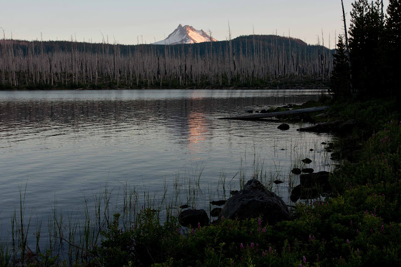
| Lovely sunset view on Olallie Lake |
As the sun set on another fun day, I made sure this time to not miss the lovely evening light. The smoke cloud died down, and I was able to capture some lovely pink light on the barren trees. A perfect finish to a perfect weekend!
(Note: our hike to Ruddy Hill was about 4.4 miles round-trip, plus an extra 1.5 miles of road walking. The total elevation gain was about 1000 feet).