Wednesday, May 30, 2018

Lyle Cherry Orchard

Okay, it's back to PNW photos and stories!  I've been hiking like crazy since returning from my Arizona trip.  Time to play catch up.


This trail had the best sign!

In late March, home from my wanderings, I was hankering for a spring wildflower fix.  The wildflowers always bloom first in the eastern reaches of the Columbia River Gorge.  With most of the Oregon Gorge trails still shut down from last September's fire, I looked to my northern neighboring state.


Columbia River views

This spring my motto has been "try new trails."  One that I'd never hiked before was the scenic path through Lyle Cherry Orchard on the Washington side.


Prairie Star

I'm not sure if it was the distance from Portland (about an hour and a half drive) or the relatively short route (the trail itself is only about 4 miles round trip) that kept me from visiting until now.
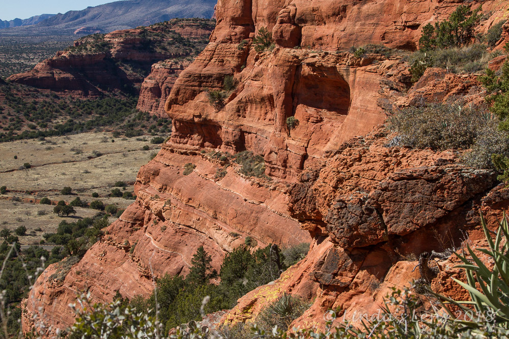

Rocky outcrop

I got a late start that Saturday morning, and after driving past overflowing trailheads at Coyote Wall and Catherine Creek, began to worry about securing a parking spot.  But luckily, the lot was only about 2/3 full.  Guess other folks didn't want to travel that far either.


Lovely unknown flower

The trail itself wasn't signed, but an obvious boot path from the parking area led me through a scrub oak forest under tall basalt cliffs.  In a 1/8 mile I came upon the famous Cherry Orchard trailhead sign.


Gnarled oak trees

And a lovely sign it was, beautifully carved lettering adorning it's face, with a couple small wildflowers painted on each side.  The lower portion ominously warned of the hazards hikers might encounter (poison oak, ticks, rattlesnakes, steep cliffs....)


Desert parsley

The sign wasn't enough to deter me from the day's goal.  Tucking my pant legs into my socks to guard against ticks, I began to climb up a small draw.  Flowers carpeted the forest here, slowing my progress.


These trees look like withered old people

The forest thinned out into a meadow and the trail began to switchback steeply uphill.  As I climbed, views opened up westward towards the tiny town of Lyle and eastwards to the drier portion of the Gorge.


Path through the grass

Steep basalt cliffs lining the Columbia River came into view, as did the higher Cascade mountain foothills.


Gorge panorama on top of the ridge

Zig-zagging up the steep meadow, I came upon the first balsamroot flower of the season.  A large clump of the cherry yellow blooms were brightening up the surroundings.
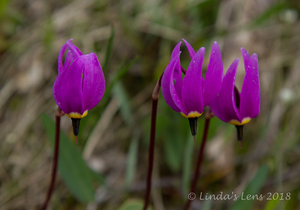

Shooting stars

About a mile up, the terrain flattened out and my trail began wandering through another oak forest. 


Remains of the orchard area

Dozens of wildflowers brightened the forest floor.  Shooting stars, larkspur, Oregon sunshine, glacier lilies, and even a couple of extremely late-blooming grass widows.


Nothing left of the homestead but fence posts

The official trail was supposed to end at an old homestead where a few surviving trees from an old cherry orchard still existed.  However, I came to the old road described in my hiking guide, and there really wasn't much to see.  A few old fence posts and more oak trees, but I didn't see anything resembling a cherry tree.  Kind of anticlimactic.


Larkspur

I continued past the homestead, following a faint road until it appeared to dead end in a cliff-edged oak grove.  The views east were quite lovely, and I had a quick snack while enjoying the scenery.


Last fall's dry leaves

This entire 500-plus acre property was purchased by Friends of the Gorge founder Nancy Russell.  Upon her death, she deeded the land to this organization, and a trail was built so all could enjoy this beautiful area.


Glacier lilies

Although the faint road continued further east, the day was growing warm, and I decided I'd done enough exploring for today.  Retracing my steps back to the homestead area, I meandered along the ridgetop, snapping photos of any flower I thought I may have missed.


The season's first balsamroot

Although I'd had the homestead all to myself, I encountered a continuous stream of hiker groups as I trekked back through the woods.  Apparently this trail was more popular than I thought!


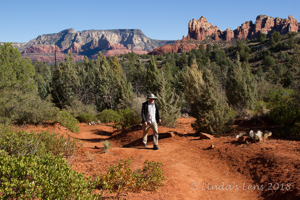
Looking down on the plateau

Descending back down the steep bluffs, I was treated to fantastic views of the stair-stepped basalt cliffs and the grassy plateau midway down.  Several people were fanned out across the plateau.  From my vantage point, they looked like ants.


Balsamroot patch

Although tempted to follow the crowd across the plateau to these cliff edges, I decided to save that exploration for another day.


Hikers admiring the Gorge view

The final half mile through the lower oak forest, I snapped photos of some of the more unusual species of flowers.


Miners lettuce

Such as the white flowers and unusual leaf of the Miners lettuce plant.  And I spied a clump of yellow monkeyflowers with red spots - a variety I'd not seen before.


Unusual monkeyflowers

Boy, it was great to be back home in the Gorge!  I've got another favorite spring trail to add to my list.


Tuesday, May 22, 2018

Sedona - Doe Mtn Trail

 (This is an ongoing series recapping my March trip to the Sedona, Arizona area)

After a most excellent morning hike on Sedona's Hog Trails and a pizza lunch, I was ready for one final adventure.  My friends Hans and Lisa picked a short but sweet trek, a trip up the Doe Mountain Trail.


Trailhead

Located NW of Sedona, a mere 5 miles from town, the trailhead didn't take long to reach (navigating Sedona city traffic was the most time consuming part!)


Red rock views as I climbed

Judging by the large number of vehicles clogging the trailhead parking lot and overflowing onto the road, this was a popular hike.  Hans found a wide spot in the road for his truck, and after a re-application of sunscreen and quick potty stop, we were off.


Cactus everywhere

Doe Mountain was a low, flat-topped mesa rising above the desert floor.  A short trail ascended 400 feet in 0.7 miles.  The relatively moderate distance and elevation gain meant my friends and I were never alone as we huffed up the switchbacks.  People of all ages and fitness levels traversed this rocky path.


Nearing the top

By now it was mid afternoon, and the sun felt very hot indeed.  Beating down upon my head, this cold-blooded mossy Oregonian was feeling a mite bit overheated.  I made many photo (aka rest) stops to snap images of the magnificent scenery unfolding the higher I climbed (and to sip a wee bit of water).


Purple cactus

The cliffs and canyons of Red Rock Secret Mountain Wilderness were visible across the valley and their views got better with every step upward.


It's a long ways down

At the very top of Doe Mountain's trail, Hans and Lisa paused for a quick rest.


Lisa and Hans take a breather

I took the opportunity to grab a photo.  Cheese, guys!  (Great pic of them isn't it?)


One of many cairns

Legs properly rested, my friends and I began to traverse the 1.3 mile trail around the mesa's edge.  Doe Mountain's summit was a wide, flat plain created from a layer of erosion resistant cap rock.  After climbing up the steep mountainside I was ready for some level walking.


This cairn was particularly tall!

The trails were littered with dozens of tall rock cairns.  Although some of them were probably intended for wayfinding, I think the great majority were just impromptu artwork.


Approaching the mesa's rim

I followed Hans and Lisa across the red, dusty mesa top to the opposite side. 


Magnificent vista

And, boy oh boy what a magnificent vista awaited!  Many of Sedona's prominent landmarks were visible. 


These people had a death wish

Although the edge dropped nearly vertical several hundred feet to the valley below, it didn't stop a few adventurous (or extremely foolish) people from perching on some precipitous rock outcrops.


Peeping over the edge

In the above photo, Lisa looks closer to the edge than she really was - but she was close enough to make Hans and I nervous.


More wide-open panoramas

Oh were the views fabulous!  I could see why so many people climbed up here.


Cactus right to the edge

I lagged far behind my friends, snapping copious photographs.  I wanted to remember everything.


Old, gnarled tree

The multi-tiered sandstone walls, the colorful cactus, the old gnarled weather-beaten trees, the green juniper bushes.  All were captured on my memory card.


Just soaking in the views

I caught up with Hans and Lisa on the mesa's opposite side.  They were perched on a rock overlooking Sedona.  The large red monoliths surrounding town rose in the distance and I enjoyed this different view of the valley.


Lots of scenery shots

Then it was time to retrace our steps back across the mesa, down the winding path and back to our waiting truck.  As we drove away, I bid these beautiful red rock mountains a silent goodbye.


Sedona from another angle

While on Doe Mountain, I struck up a conversation with a man from Seattle, also armed with a camera.  He'd come out to Arizona by himself and was also visiting both Sedona and the Grand Canyon.  We compared notes about what sights we'd seen and chatted at length about the incredible beauty of the area, and the merits of solo travel.  Although I'd been apprehensive about traveling here on my own, the man's enthusiasm made me grateful I'd listened to my inner voice, taken the leap and made this journey.


Goodbye Arizona!

A huge thank you to Hans and Lisa for introducing me to this wonderful corner of the world.  I had such a fabulous time, I don't know how I will ever repay you!  Thank you for sharing your home, being amazing tour guides, providing delicious meals (and beer!), and putting up with my constant photo taking.  Hopefully we can meet up again in the future for another great hike or two. (And of course more beer drinking!)

Please check out Hans and Lisa's travel blog at Metamorphosis Road.


And if you've missed any of my Arizona travel posts, catch up with the following links:

Grand Canyon, the Introduction
Critters of the Canyon
Grand Canyon - Of Hikes and Mule Trains
Grand Canyon - Quest for a Sunset
Grand Canyon - Sunrise and Desert View
Sedona - Hiking the Hiline Trail
Sedona - National Monuments Part One
Sedona - National Monuments Part Two
Sedona - the Hangover Trail
Sedona - Chicken Point and the Hog Trails


Wednesday, May 16, 2018

Sedona - Chicken Point and the "Hog" Trails

 (This is an ongoing series recapping my March trip to the Sedona, Arizona area)

After a wonderful hike on Sedona's Hangover Trail, I was relaxing in my friends Hans and Lisa's RV when Lisa gasped "Oh my gosh - look at this!"  On her laptop was a YouTube video showing some mountain biker riding across an extremely steep redrock cliff.  The "trail" (if it could be called that) happened to be in Sedona, and was called the White Line, after a prominent white band in the rock.  (See the video here.)

Guess what?  That particular place happened to be on tomorrow's hiking agenda.

Another great morning in Sedona!

Besides the fantastic scenery, one of the things that blew me away about Sedona was the sheer number of hiking and biking trails surrounding the town.  Routes fanned out in all directions from the city limits.  On the final day of my trip, Hans and Lisa took me to explore the Hog trail system on Sedona's southeast side.


Scenery on the Broken Arrow Trail

Hans parked their truck at the Broken Arrow Trailhead.  Although it was early Monday morning, he had to squeeze into one of the few remaining spots.  As I soon found out, this trail system was wildly popular with the locals.


Pink jeep giving customers a thrill ride

The Broken Arrow trail wound through scrubby forest, emerging onto a wide, sandstone plateau.  As we climbed along the foot of several tall rocky pinnacles, I noticed a couple of Sedona's famous pink Jeeps roaring over a primitive road below.  Jeep tours are big business here, and the judging by the number of them I saw that day, pink Jeeps seem to have a corner on the market.  My friends and I stopped to watch one of them navigate a steep downhill, much to the delight of their passengers.


Approaching Chicken Point

After traversing more red sandstone, about a mile and half later we came to the famous "Chicken Point." - a rocky formation jutting out over a broad valley.  Rising up from either side were near-vertical sandstone walls.  Perched high on one of these walls was the "White Line" biking route, of YouTube video fame.


It's a popular place!

Chicken Point was an extremely popular place.  Not only hikers, when we arrived two pink Jeeps were also parked nearby, their passengers fanned out across the wide mesa.


Astounding scenery here!

Luckily, the Jeep tourists didn't linger very long, and after a few minutes everyone packed up and left.  Much to our delight, my friends and I found we had the place nearly to ourselves.


Hans and Lisa take a break

Hans, Lisa and I hiked to the very end of Chicken Point's outcrop, had a seat, and enjoyed the view and a snack.  Rocky spires and flat-topped buttes rose in all directions.  Totally breathtaking - break spots just don't get any better!


Mountain bike group

Naturally, our solitude was short-lived.  Five minutes later a large group of mountain bikers wheeled up.  Most of the pack dismounted several feet away and sat down on a nearby ledge.  But a few of them decided to ride onto the vantage point where my friends and I were relaxing.


Ridin' the rough trail

We struck up a conversation with the bikers, and discovered they were from Scotland and Ireland.  These young people were delightful to chat with (loved their accents!).  Hans asked if any of them were going to attempt the White Line trail above us, and they all shook their heads emphatically.  No one was that crazy!


The famous "White Line" mountain bike trail

As we sat taking in the scenery, more hikers and bikers arrived.  Then another pink Jeep pulled up, and its passengers wandered out onto Chicken Point.  The place was getting awfully crowded - time to move on!  But just as we started to pack up, someone mentioned they'd seen a mountain biker heading up to attempt to ride the White Line.  Should we stay and watch?  Lisa put it best when she commented it would be amazing and nerve-wracking at the same time.  Although such a feat would be incredible to see, if things went wrong none of us wanted to witness a biker falling to his death (considering the White Line was 200 feet above the valley, any slip would almost certainly be fatal).


Onward!

After waiting several minutes with no sign of a biker (which was sort of a relief), my friends and I decided to move on.  Back down the Broken Arrow Trail we traveled, retracing our morning's steps.


Photo op

But the scenery was so spectacular, I didn't mind in the least!  A good opportunity to capture anything I'd missed the first time around.


Heading towards the Hog trails

Instead of heading back towards the trailhead, after about a mile, my friends led me onto another trail.  After following small red rock canyon we came upon the first of the hog-themed mountain bike trails, "High on the Hog."


Large sandstone formation

I discovered an entire network of mountain bike trails with pig-themed names.  As with all the Sedona area mountain biking paths, these wandered up, over and through huge sandstone formations.  Again, some of the terrain was so steep and rocky, I couldn't believe people actually rode bikes on it.


The views of distant pinnacles

But oh was the scenery spectacular!


Cool pattern on the sandstone

I lagged behind Hans and Lisa, snapping away.  Luckily, Lisa kept looking back, and waiting at key junction spots to ensure I didn't get lost.


More follow the dots

The next trail was named "Hog Heaven" and like the previous it wandered through the redrock, in and out of washes and down steep slopes.  I even got another chance to perfect my butt-sliding skills on some of the more gnarly spots.


Hidden water pockets


Another view of Sedona

Rounding a bend, the city of Sedona once again came into view.  I was very jealous of the townspeople, living so close to this amazing trail system.


More redrock formations

Although these trails were meant for biking, the only people on two wheels we met were a young boy and his grandfather.  And they definitely didn't look experienced enough to navigate these routes!  (The grandpa was riding an old ten speed)


I loved all the pig themed trail names

The next junction took us to the "Hog Wash" trail.


"Pigtail" was my favorite

And then to my favorite trail name of the hog system - "Pigtail."


Lisa on the trail

Finally, a short jaunt on the "Peccary" Trail brought us back to "Hog Wash" and then the Broken Arrow Trail once again.  It was here near the end that we met a couple more mountain bikers (looking much more experienced than the grandpa and his grandson).


Interesting rock formations


Pinnacles in the distance

Today's trek was shorter than the two previous hikes, a route of only 5 miles.  But the weather was much warmer than previous days.  By late morning the sun was beating down, and coming from cold and rainy Oregon, I wasn't used to this at all.  It wasn't super hot (maybe mid-70s) but it was enough to wear me out.


This trail had lots of interesting rocks

By the time we arrived back at the trailhead, I was hot, thirsty and hungry.  But a tasty pizza at one of Sedona's local restaurants and several glasses of water revived me nicely.  I was ready to tackle another short hike.


One of many mountain bikers

For the afternoon, Hans and Lisa had one final hike planned to complete my whirlwind tour of Sedona.  Which I'll cover in my next post!