Showing posts with label camping. Show all posts

Wednesday, July 16, 2014

Campin' at Clear Lake

With Fourth of July weekend approaching, my hubby and I wanted to get away.  On the 4th, there's so many fireworks shot off (both legal and illegal), our neighborhood resembles little Beirut.  Tired of being in the middle of the blast zone (not to mention trying to calm our terrified dog), Roger and I decided to head for the mountains.


The lake

Time to explore a new place!  Our destination - Clear Lake, high in the Oregon Cascades, situated between Santiam and McKenzie Passes.  It came highly recommended by one of my co-workers, who'd recently camped there.


Our killer lakeside camping spot

Since we didn't have reservations, Roger and I both took vacation July 3rd to beat the holiday rush.  Leaving Portland early that morning, our plan worked like a charm.  Not only did we get one of the walk-up campsites, we scored a killer lakeside spot.


The reflections were nice

Clear Lake totally exceeded my expectations.  Such a gorgeous place!  Situated high in the Central Oregon Cascades, just west of Mount Washington, this body of water was created when an ancient lava flow dammed the McKenzie River.  The spring-fed water bubbling into this basin makes the lake so clear you can see all the way to the bottom (yes, this lake was very appropriatly named!)


The guys trying some fishing

Due to it's clarity, the lake's water was a fetching shade of blue-green.  The shores were ringed on three sides by lovely old-growth forests.  The fourth side was cleared due to the lava flow.  But the rough, black lava was quite interesting, and scenic in its own way.


A few tiger lilies hangin' out

After setting up our camp, and cooking brats over the campfire, I was ready for some exploration.  A few short steps from our tent got me to the shore of Clear Lake.  The banks here were very brushy, but a couple of clearings provided access.


Lovely evening water patterns

A 5.5 mile loop trail circled Clear Lake.  You know me, of course, I had to hike it!  Leaving Roger back at the campsite with our old dog, I headed 'round the lake counterclockwise.


Bratwurst roast

I started out in the campground, passing by other campers, all enjoying the forested shade on this hot summer day.  Approaching the boat dock, I observed a few kayakers and fisherman in rowboats.  Motorized boats are not allowed here, which I loved.  The motorboat ban attracts a totally different crowd, usually those who want a quiet, serene outdoor experience.


Trail around the lake

And then, I hit the lava beds.  The cool forests gave way to barren ground and direct sunlight.  Very hot direct sunlight.


Hiking through the lava fields

The dense, black lava rock didn't help matters.  It felt as though the rocks were absorbing the sun's heat and reflecting it right back at us poor hikers.


Green water and more lava

Yeah, it was a very hot trek through the lava fields.  Thankfully, the Forest Service had constructed a paved path so that hikers didn't have to traverse the rough lava rock.


The water was an unusual color

Even though this portion of my hike was toasty, the lack of trees made for some great views.  Around every corner was another gorgeous cove, with glittering aqua-blue water.  Lush green vegetation surrounded the shoreline, adding to the color palette.


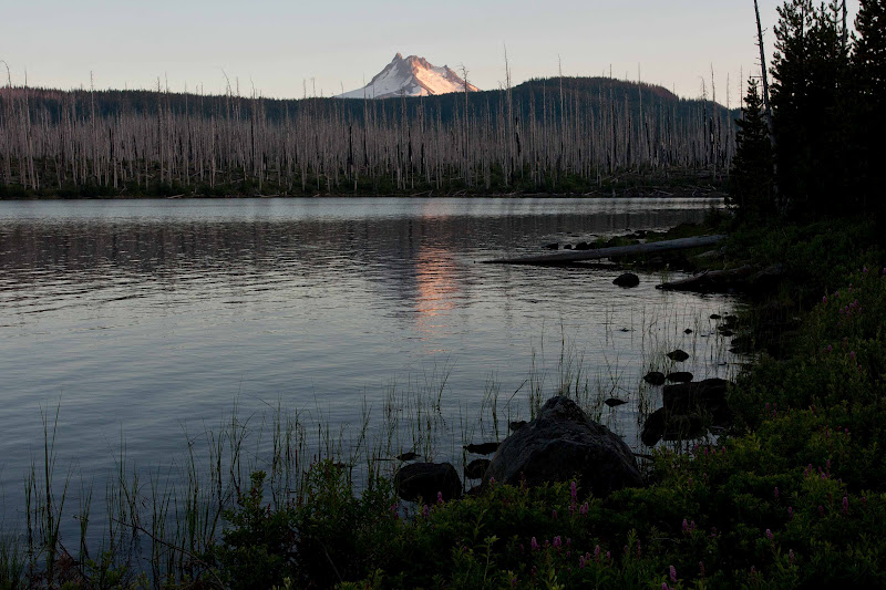
Two of the Three Sisters mountains rise over Clear Lake

At the lake's northern end, I passed by the "Great Spring" a rushing 300-foot long river that miraculously emerges from under an old lava flow.  The water in this pool was the clearest I'd ever seen.  It was an eerie metallic blue color and very, very cold.  I later read that the water from this spring maintains a constant 38 degree F temperature year-round, which prevents the lake from freezing in winter months.


Shoreline flowers

Rounding the northern tip of Clear Lake, I continued to take in some very nice views of the opposite shore.  Then the small resort building came into view.  The county operates a tiny resort with a restaurant, cabins, and rowboat rentals.  Rising above the forested shoreline, the tips of two of the Three Sisters mountains revealed themselves.


Wonderful reflections at the lake's outlet

I continued around another long inlet creek, which seemed to take forever to traverse.  Seeing more and more people on the trail made me realize the resort, and civilization wasn't far.


Beautiful forest

After hiking in solitude for most of the way thus far, it was a shock when I finally made it to the first set of cabins.  From there, I wandered along a gravel road, dodging bikes and people until arriving at the resort restaurant/general store. 


Trees and sky

The store sold a very limited selection of food and drink.  But a large bottle of ice tea called my name.  It tasted mighty fine to this hot, sweaty hiker.  I guzzled that bottle in no time flat.


More of the lake's green water

Refreshed, I was ready to tackle the final two miles.  The trail dived back into thick woods.  The cool forest was a welcome relief.  I passed by some enormous old-growth Douglas Fir trees.  I tried to capture one with my camera, but the image just didn't do it justice.


Pretty flowers

Then I crossed a log footbridge over the lake's outlet creek.  The water's colors here were amazing shades of blue and green.  Surrounding trees and bushes reflected themselves perfectly in the colorful waters.


Time for dinner!

Rounding the south end of the lake, I traveled by some lovely little bays.  The late afternoon light illuminated the water's color to a brilliant aqua blue.  And there were more amazing reflections.  Simply beautiful!


Baby ducks play in the water

I ended up back at our campsite just as Roger was putting baked potatoes and steaks on the grill.  It all looked so good!  Hiking around the lake had given me an appetite.  We finished our meal roasting "adult" marshmallows dipped in Bailey's Irish cream.  Highly recommended!


Mama and babies on a floating log

After dinner, Roger and I sat around the fire, listening to some baby ducks splash and play in the water below.  The peeping they made sounded almost joyful.  When I went down later to photograph these cuties, I spotted a mama duck and two babies perched on a floating log.  (All together now.....awwwwwwww!!!)

Tomorrow, Roger and I planned to visit two waterfalls within hiking distance of our camp.  I also hoped to hike one of the trails at nearby McKenzie Pass.  But those adventures will be part of my next two blog posts, so come back and visit!


Sharing with:  Our World Tuesday and Wednesday Around the World.

Tuesday, August 28, 2012

Olallie Lake Campin' Trip Part Two

Sorry it's taken me so long to write "part 2" of my Olallie Lake camping adventure.  (I don't like to leave my readers hanging!)  But last weekend I was busy with a little relay race called "Hood to Coast" (those of you in the running world may have heard of it!)  And tomorrow I'm leaving for South Dakota to visit my family - so I'm hoping to get this post out before I go.


Size matters!  Click on any photo to enjoy a larger version.


Fireweed close-up
 
Day two of our camping trip began with Roger heading to the water - fishing pole in hand - to again try his luck landing a trout.  I was itching to explore Olallie's eastside lakeshore trail.  Grabbing backpack and camera, I set out to do just that.


Olallie Lake & Mt. Jefferson
 
The path from our campground to Olallie Lake's general store is about two miles.  It contours around the east shore, beginning in dead trees of the old fire, continuing into lovely subalpine forests, until finally reaching another campground and the resort proper.


Classic Olallie Lake boat dock photo
 
Early morning sun reflected off the lake, turning the water a brilliant blue. The clear skies, lovely at this hour, promised warm temperatures later in the day. I started my trek in the burn zone along the south end.  After a mile of walking, Mt. Jefferson began to make it's appearance over the southern skyline.  Canoes and rafts bobbed in Olallie's waters.  I encountered a couple of fisherman perched on rocks along the bank.  I made occasional photo stops to capture the nice lake views and prolific fireweed flowers.
 
 
Path around Olallie Lake
 
After about an hour of hiking, I reached my destination - Olallie Lake's boat dock and tiny general store.  From the dock, there's a classic view of the lake with Mt. Jefferson in the background.  Although midday light was not the best for photos, but I couldn't pass up a chance to capture this scene. 
 
 
Roger stands at the viewpoint
 
I returned to our campsite in time for lunch.  Roger, not having any luck luring a fish, had to settle for sandwiches instead.  After we finished eating, I asked my hubby if he'd like to accompany me on another hike.  The nearby  trail to Ruddy Hill was another of the unfinished "100 hikes" I had my eye on completing.
 
 
Fabulous view of Olallie and Monon Lakes
 
Roger was a good sport, and agreed to come along on another of my adventures.  The trailhead to this particular hike was 3.5 miles from our campground, down a rough gravel road.  We bumped along the first mile and a half no problem, but just past the final campground at Horseshoe Lake, a sign warned that the road ahead was unmaintained and not suitable for passenger vehicles. 
 
 
Horrible rocky road
 
But Roger was driving his new truck, so we thought "no problem" and continued on.  The road became horribly steep and rocky.  Our speed slowed to a mere crawl.  After a half mile of bumping along, we came upon a wide spot in the road, and Roger said "enough!"  He suggested we park the truck and walk to the trailhead.
 
 
Gibson Lake
 
So we continued on foot following that nasty, rocky road.  The dusty roadbed was mostly in the sun, so it was a hot, grimy trek.  Looking at some of larger rocks, you could see scrape marks where vehicles had bottomed out.  As expected, traffic was light.  But we did see a couple of pickups come bouncing along, and even one ancient Cadillac (we were both amazed the car had made it this far). 
 
After a long 3/4 mile march, Roger spotted a small sign next to a faint path.  It was the Gibson Lake trail, one of two leading to Ruddy Hill.  The other, the Pacific Crest Trail, was still another 0.7 of a mile down the road.  Not wanting to walk on this awful road another step, Roger and I both eagerly ditched our roadwalking for a nice, forested trail.


Mt. Jefferson from Ruddy Hill
 
We walked through a lovely alpine forest, and soon came upon tiny Gibson Lake.   It was a classic high mountain pond, surrounded by tall firs.  Continuing, our path climbed through the woods along a ridge until it reached a rim overlooking Horseshoe Lake.  Further down, we came upon a rocky clearing where Olallie Butte and a tiny Mt. Hood dominated the view.  Very nice!
 
 
Still some lingering snowdrifts
 
Then our trail intersected with the PCT.  Following the PCT for a very short distance, Roger spotted the sign to the spur trail for Ruddy Hill's summit.  The large, forested cinder cone rose up before us.  Yep, we were in for a climb. 
 
 
Great view of Olallie Butte and Mt. Hood
 
And what a climb it was!  The distance to the top was only a half mile, but the elevation gain was nearly 500 feet.  And it seemed to be concentrated in a few short sections.  I huffed and puffed under my backpack's weight, as my calves screamed.  By now it was midafternoon, and temps had risen to toasty levels.  Sweat poured down my face.  Ugh!  (who's idea was it to climb this thing, anyway?) 
 
 
Back at ultra-blue Gibson Lake
 
But I kept going, trying to keep up with my mountain goat husband.  Finally, I spied a large white object up ahead.  What in the world was that?  Reaching the top, I found myself in a large heather meadow with a huge snowdrift still lingering in a shady area.  Snow in August!  Only in the Cascades.
 
 
Smoke from a forest fire
 
I took a handful of snow and put it under my hat.  That felt good!  Then I joined Roger at the summit proper to take in the marvelous views.  Mt. Jefferson loomed large.  Forested hills spread out in all directions.  The soil at the very top was a red cindery rock, hence the name "Ruddy Hill."  This hill once used by rangers to spot forest fires, still had an ancient wooden telephone box sitting near the meadow's edge.  Very interesting stuff!
 
 
We had huckleberry bushes right in our campsite!
 
After a quick water and snack break, it was time to go.  Although I initially wanted to return via the PCT and make a loop hike, the heat was doing me in.  Not wanting to add more distance than we had to, Roger and I agreed we'd stick to the Gibson Lake trail.
 
 
Yummy ripe huckleberry
 
Our trip back was hot and mosquitoey, but uneventful.  We stopped at Gibson Lake for a quick wade in it's chilly waters  (a wonderful way to revive!)  Rounding Gibson lake, I spotted a plume of smoke rising from a nearby hill.  Uh-oh!  Looked like a forest fire.  Roger and I stood observing it for a minute or two.  Although the fire looked to be quite far away, we didn't like the look of things, and decided it was time to head back to the campground.


Roger shows off his haul
 
After an endless walk down that crummy, dusty road, we finally were back at the truck.  Arriving back at the campsite, Roger noticed a helicopter flying low.  Something was definitely happening with that fire.  We watched a couple of airplanes join the 'copter flying towards the smoke plume.  Although the smoky cloud hung in the sky, it didn't grow, and the smoke stayed away from the lake.  Roger and I figured we were safe.  (Note - two weeks after our trip, they ended up evacuating the Olallie Lake area due to a fire.)
 
 
Golden evening light on the dead trees
 
Our campsite had lots of great things going for it, but the best feature of all was the numerous huckleberry bushes growing right in our site.  And the huckleberries were ripe!  Roger and I picked a large ziplock bag to take home - they were so sweet and good! 


Lovely sunset view on Olallie Lake
 
As the sun set on another fun day, I made sure this time to not miss the lovely evening light.  The smoke cloud died down, and I was able to capture some lovely pink light on the barren trees.  A perfect finish to a perfect weekend!
 
  
(Note:  our hike to Ruddy Hill was about 4.4 miles round-trip, plus an extra 1.5 miles of road walking.  The total elevation gain was about 1000 feet).  


Tuesday, August 21, 2012

Campin' at Olallie Lake

There's a couple trails in the Olallie Lake area I've yet to visit.  On the ever-shrinking list of "uncompleted 100 hikes," these were next on my agenda.  But Olallie Lake is a long drive from Portland (almost three hours). In order to bag both hikes, I suggested a weekend camping trip to my hubby.


Size matters!  Click on any photo to enjoy a larger version.

On the shore of Olallie Lake

It's been many years since we've camped at Olallie Lake.  This lake is part of a larger scenic area consisting of a high forested plateau and lots of small, charming mountain lakes.  It's very remote - located deep in the Mt. Hood National Forest sandwiched between Mts. Hood and Jefferson.  I remembered a long drive over bumpy gravel roads to get there.


Fireweed flowers were everywhere

Thankfully, the roads have improved from our last visit.  My hubby and I arrived on a hot Friday mid-afternoon and scored one of the last shaded campsites near the lake.  After unpacking and putting up the tent, Roger grabbed his fishing pole and set out in search of the "big one."  I loaded up my backpack and camera, ready to explore the first of my new trails.


Monon Lake with the tip of Mt. Jefferson

Yes, "New Hike Friday" has been resurrected.  Today's trail of choice was a path from Olallie Lake around adjacent Monon Lake.  Only a half mile apart, these bodies of water are connected by a well-used path.  Once you reach Monon Lake, the trail continues, following the shoreline for a total of 2.9 miles.

It was another trek through an old fire zone.  In 2001, a large forest fire swept through this area and ghostly gray trees bore stark reminders of the disaster.  But like Canyon Creek Meadows, this area was well on its way to recovery.  Large bushes and small trees covered the ground.  Rose-colored fireweed flowers brightened the scene.


Ghostly trees

Vivid blue and beautiful, Olallie and Monon are the largest lakes in the Olallie Scenic Area.  But they couldn't be more different.  Olallie Lake boasts a small resort with cabins, boat rentals and a tiny general store.  It is ringed with three USFS campgrounds.  Since Olallie Lake is used as a drinking water source, swimming is not allowed, but fishing and boating are permitted. 


Olallie Butte makes a perfect reflection on Monon Lake

Monon Lake, on the other hand is totally undeveloped. No official campgrounds at all. But swimming is allowed, and there's a nice trail following the entire shoreline. Many people make the trek to Monon to get their water sports fix. (And I noticed lots of "squatter" campers clustered between the road and the west shore).


Boggy meadows around Monon Lake

I began my afternoon stroll on Olallie Lake's south shore.  It took a little bushwhacking to finally locate the trail, but once found, it was an enjoyable half mile from my campsite to Monon Lake.  Fireweed flowers bloomed profusely near the water's edge.  Olallie Butte, rising above the lake-dotted plateau, was my constant companion.  As I left Olallie's shore behind, I entered the burn zone from a previous fire. 


Entering the burn zone

Once again, this fire-ravaged area was much more interesting and scenic than expected.  The silvery gray dead trees made for a beautiful contrast with the blue sky.  Flowers and green shrubs rose from the forest's floor.  Good photographic material. 


Fireweed in the evening sun

As I approached Monon Lake, I was delighted to see the very tip of Mt. Jefferson appear over the treed horizon.  I circled the lake clockwise, first making my way through the burn zone.  As I approached the southern edge, dead trees gave way to untouched forest and swampy meadows.  In some areas, logs had been placed over the trail.  I'm assuming this area gets quite muddy certain times of the year.  Looking across the lake, I noticed Olallie Butte making a nice reflection on its lovely blue waters.  Kodak moment!


Reflections

I continued along the western side of Monon Lake, past many primitive camps, where people had just pulled off the road and squeezed a tent in the narrow space between the road and shore.  After a half mile, I left the squatters behind, and wound through another brilliant green meadow, complete with boardwalks and a cute footbridge.  This led me back to the north side of Monon Lake, through another burn zone.  This area looked to have received the brunt of the fire's wrath.  Many trees still bore blackened scars from the inferno.  A very somber place.


Happy Anniversary to us!

I returned to our campsite to find Roger stoking a nice campfire, and prepping a steak dinner.  I opened up a bottle of wine and we had a toast.  It was our 27th wedding anniversary.  I couldn't think of a better way to celebrate than being outdoors at this lovely lake with my wonderful husband.


Mt. Jefferson evening reflection on Olallie Lake

After dinner, the sun began to set over the forested hills.  It's rays turned the adjacent trees a soft pink hue.  Too late, I grabbed my camera and hurried to the lakeshore.  I caught the sun's last rays on Mt. Jefferson before it was gone for the night.  And I did get one nice reflection of the mountain on Olallie's ripply surface.

Ahhh.....what a great day!  And tomorrow held the promise of another new hike to explore.  Stay tuned for my next post for photos and story.


Linking to:  Share Your Cup Thursday.