Showing posts with label Mt. Adams. Show all posts

Tuesday, September 23, 2014

Shorthorn Trail

Late summer is a perfect time to explore the Cascades' high mountain meadows.  The bugs are gone, trails are snow-free, and sunny days are almost always guaranteed.  Last September I'd visited Mt. Adams for the first time (read about it here).  I discovered jaw-dropping mountain scenery that left me wanting more.


The grand dame herself - Mt.Adams

Fresh from my South Dakota journey, I was hankering for a hike one of my beloved PNW mountains.  The Portland Hikers website posted a trip report on Mt. Adams' Shorthorn Trail.  The photos and description were so enticing, I knew I had to pay a visit.


The trail started in an recent burn area

Mt. Adams, located across the river in Washington State, is a long drive from Portland.  It took me nearly 2 1/2 hours to reach the trailhead.  But I woke up early, put in some good music, and in no time was bumping along the rough gravel road near my destination.


Blackened bark peeling from the trees

The Shorthorn Trail starts at the Morrison Creek Campground.  The entire area, including the campground, was charred in a 2012 wildfire.  I noticed the campsites all had new picnic tables, and the bathroom looked like it had been recently installed.  But the trees left standing were all gray and dead.  It appeared the Forest Service had been cutting down the burned trunks, as there were piles of logs scattered throughout the area.  Not a very scenic place to camp, but on the plus side you'd have unlimited firewood!


Beautiful marshy meadow

I hit the trail, climbing through the blackened forest.  Although the trees were dead, I saw many birds flitting about.  I even spotted a pair of woodpeckers combing through the gray trunks.  The path climbed, steeply at times, offering occasional tiny glimpses of Mt. Adams through the trees.  A carrot to keep me going!


Happy to see this sign!

It was a long, nearly viewless three miles.  At first I enjoyed checking out the burned trees, all shedding their blackened bark (it was like the trees were all stripping off their clothes!)  But aside from that, the only excitement was traversing a vivid green marshy meadow, and then crossing a steep, gravelly stream bed.  But soon after this creek, I climbed one last slope, and there before me was the Round the Mountain Trail.


Amazing Mt. Adams view from Round the Mountain Trail

It was here I got my first grand view of Mt. Adam's bulky summit.  Spectacular!


One of many creek crossings

Thankfully, the Round the Mountain Trail is fairly level, with minimal elevation gains and losses.  I headed westward on this trail.  Mostly above treeline, I was treated to some great panoramic views of the adjacent hills and mountains.


Vibrant pink monkeyflowers

I crossed several gushing mountain streams, all originating from melting glaciers.  Each crossing offered stunning views of Adams as you looked up toward the rocky banks.  A couple creeks were also lined with green vegetation and vivid pink monkeyflowers.


Every creek crossing had stunning mountain views

Stream crossings are not my favorite part of hiking.  I always get nervous when I have to rock-hop over cold, fast-moving water.  But through the years I've discovered the crossings always look much worse than they really are.  Such was the case with all the creeks I encountered this day.


Looking back towards Mt. Hood

Two miles down Round the Mountain Trail was a path leading to a tiny mountain pond - Lookingglass Lake.  The hike recap I'd read described this little lake as incredibly scenic.  When the wind wasn't blowing it was supposed to create perfect reflections of Mt. Adams on it's glassy surface.


Friendly butterfly

It took longer than expected to reach the spur trail to Lookingglass Lake.  I was starting to think I'd missed the turnoff when I spotted the sign.  One more mile!  The path dived downhill through a lush meadow.  I noticed remnants of a large wildflower bloom.  Then I spied bright orange butterflies flitting through the shrived flower petals.  It took a few minutes, and a lot of patience, but one friendly butterfly did stop, and lingered long enough to allow a few images.


I finally spy Lookingglass Lake

This trail wound steeply downhill, recrossing the same stream multiple times.  I began to tire of rock-hopping and started to wade through the water instead (it wasn't very deep).  This last mile seemed to take an eternity.  More than once I questioned if this was the right trail.  But then I spotted a lovely blue-green lake through the forest.


Green grass brightens the lakeshore

Ohhh.....was it ever beautiful!  Surrounded by lush green grasses, the lake itself was a shining teal color.  Although surrounded by ghostly gray dead trees (sadly the forest fire passed this way too) it was still very stunning.


Perfect mountain reflection!

Following the shoreline to its opposite end, I was happy to discover that perfect reflection I'd come so far to find.


Gentians blooming around the lake

Lucky for me, the winds were calm.  The lake's glassy surface gave a perfect mirror image of Mt. Adams, towering high above.  The burned out forest, although not as scenic, did open up more views of this mountain.


Mt. Adams fills the sky

After taking the obligatory dozens of photos, I sat on a log, ate my lunch, and enjoyed the scenery.


More great reflections

I could've lingered at Lookingglass Lake all afternoon.  But, after a peaceful hour, I knew it was time to head back.  I finished the loop around the lake, following a faint trail until it petered out into a marsh.  Not watching where I was going, I ended up stepping into knee-deep water (cleverly hidden by a bed of thick moss).  My boots filled with water.  Although my feet got wet, the icy cold water felt good on my tired feet.  The day was getting warm, and anything cold was most welcome!


Colorful creek crossing

I climbed back up until again reuniting with Round the Mountain Trail.  Retracing my steps, I crossed back over the same streams.  Now that my feet were wet, stream crossings became a snap.  I didn't worry about rock hopping, and instead plowed right through the water.  One particular stream was lined with rust-colored rocks (must've been some iron minerals in them) and was especially scenic.


Rock cairns mark crossing points

A few stream crossings were marked with cute little rock cairns.  This one, with it's multicolored rocks, was my favorite.


Clear, glacial stream

I enjoyed my trek back on Round the Mountain Trail.  Although it ducked back into the forest in a few places, for the most part, I was treated to endless open views, of the surrounding foothills, Mt. Adams, and the adjacent peaks of Mt. Hood and Mt. St. Helens.


Back through the burn zone

Hitting the last junction, I began the final leg of my journey, down the Shorthorn Trail.  Trekking back down through the viewless burned-out forest seemed endless.  My feet were hurting, the temps toasty.  Dust billowed up from my footsteps.  This part wasn't much fun at all.  I was never so happy to see the campground and my car. 


A wonderful place!

I've discovered another magical place on Mt. Adams.  Lookingglass Lake is definitely another jewel on Mt. Adams' crown.

Stats for the day:  12 miles, 1800' elevation gain.

Sharing with:  Our World Tuesday and Wednesday Around the World.

Tuesday, October 22, 2013

Magnificent Mt. Adams

In many states, Mt. Adams would be a star attraction. Rising up to an elevation of 12,276 feet it's taller than Mt. Hood and what's left of Mt. St. Helens.  But because this mountain is surrounded by other more popular Cascade peaks, it's often overlooked.  I've admired its massive white bulk from viewpoints on many a hike.  But have I ever bothered to pay a visit?   Nooo.....


Mt. Adams emerges from the burn zone

Because Mt. Adams is far enough away from Portland and Seattle, it doesn't get the crowds like its sister peaks of Hood, Rainier, and St. Helens.  Quite of few of my friends have climbed the mountain, and some have even skied up and down its slopes.  But I've never had the desire to drive the extra distance to check it out.  Finally my friends John and Young went on a midsummer hike and brought back glowing reports of breathtaking wildflower meadows.  OK, Mt. Adams this time you've got my attention.  Time for me to pay you a visit.


Wildflowers rise from ashes

One week in mid-September I got my chance.  After dreary cloudy skies all week, the weatherman predicted Thursday would be the only sunny day for awhile.  Not wanting to waste it sitting around at work, I asked for the day off, deciding to make Mt. Adams my destination.  This might be my last chance to visit before winter set in.


A glimpse of Mt. Hood

I left my home early, and drove the nearly three hours to the South Climb Trailhead.  Although the day had a foggy start, by the time I arrived, promised sunshine was illuminating the mountain.  The trail started off climbing through a forest of scorched trees, victims of a recent 2012 fire.  Although sober to view, the blackened woods had an eerie beauty.  I fired off numerous pictures while trudging along.


Fall colors are starting

After ascending for nearly a mile and a half, I reached the intersection with the Round the Mountain Trail.  This mostly level trail encircles three quarters of Mt. Adams and would be my path to the lovely Bird Creek Meadows.
 

Grand mountain view

I left the burn zone behind and entered an area of scraggly trees at timberline, and then crossed through a cool ancient lava flow.


Crossing the lava flow

Although the morning had been chilly, moving along had warmed me up enough to peel off my layers.  The temps were perfect for hiking.  The clear, blue sky meant I could see for miles.  And the Round the Mountain Trail provided lots of viewing opportunities.


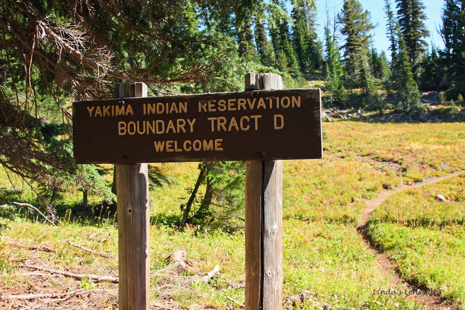
Entering the Yakima Indian Reservation

After following this trail for nearly two miles, I entered the boundary of the Yakima Indian Reservation.  This tribe won jurisdiction of the southeast flank of Mt. Adams, with the condition to allow public access.


Beautiful creek

Although my hike had been great so far, it's here that the really wonderful scenery began.  The place was full of verdant green meadows, crossed with cute mountain streams.  The trail was well-signed and in great shape, with most of the creek crossings spanned by new, sturdy log bridges.  The Yakima Nation appeared to be doing a great job maintaining this trail network.


Lovely green meadow

Although the summer flower show was long gone, huckleberry bushes were donning their red fall clothing, making lovely crimson splashes amongst the greenery.


The trails were well signed

I came upon a junction with a trail sign that directed hikers to Crooked Creek Falls.  It was only a quarter mile away.  Never passing up a chance to see a waterfall, I decided to take the side trip.


Last of the summer flowers

The path followed an absolutely lovely creek, rimmed with electric green moss.  A few straggler asters bloomed in the adjacent meadow and I captured some bees vying for the last of the pollen.


Lush green creeklet

It wasn't long before I heard the sound of rushing water.  Turning a bend in the trail, I got a glimpse of a large rock cliff.  Smack dab in the middle was the pretty white cascade of Crooked Creek Falls.  At 50 feet in height, it was impressive indeed.


Crooked Creek Falls

I spent some time taking photos of this beautiful waterfall, from every conceivable angle.  I didn't have my tripod, so all the shots had to be very quick exposures, with none of the silky smooth water that a long exposure would give.  But the fast shutter speeds did a great job of capturing the motion and raw power of this good-sized cascade.


This way to Hellroaring View Point!

I returned to the Round the Mountain Trail for another mile and a half, before finally entering the famous wildflower paradise of Bird Creek Meadows.  In late summer, I've heard this place erupts in the best floral display anywhere.  Sadly, by mid-September the blooms were all gone, and I was left trudging through nothing but ultra-green meadows (gee...darn!).


More vibrant reds

Leaving the main trail, a side path led hikers up to a place called "Hellroaring Viewpoint."  A few hundred feet of climbing was required.  As I gained elevation, the trees became shorter, and the terrain more open.  Mt. Adams began to show itself on a regular basis, and I made frequent photo stops to capture just one more image.


Breathtaking view from Hellroaring view point

And then I came upon a cliff-edge viewpoint.  And there was Mt. Adams, front and center, right in my face.  The terrain opened up to a fabulous view of the Mazama Glacier (shrunken by summer sun), and the entire drainage basin of Hellroaring Creek. 


Perfect spot for a selfie!

Oh, it was amazing!  I tried to capture its immensity, but photos did not do it justice.  This area alone was totally worth the long hike in.


Rutted trail above Hellroaring view point

The description in my hiking book mentioned a faint trail above Hellroaring Viewpoint that followed a ridge, ending at an iceberg-filled glacial lake.  It sounded like an interesting destination, and was only 1.7 miles away, so I decided to extend my trip.


Looking back down the valley

Let the climbing begin!  My trail  rose steeply from the viewpoint.  Slogging along, gasping for breath, I attempted to follow a faint footpath through the rocky terrain.  Many times it was hard to determine the actual trail.  Intermittent cairns helped with wayfinding, but there were times I stumbled along through the rock gardens, not sure if I was on the right path.


Iceberg Lake was just beyond this cinder dune

After crossing a snow-filled depression, I found myself at the foot of a massive cinder slope.  My gps showed the lake just beyond this tall mound of rock and ash.  So close!  All I had to do was ascend this slippery hill.

But easier said than done.   The slope was entirely loose rock and soil.  For every step I took, I slid back at least half as far.  Large rocks tumbled around me, and I often found myself dodging boulders.  Progress was super-slow.  Fighting this slope, I was burning tons of energy.  After reaching the halfway point, I checked my watch.  It was 1:30, and I'd yet to have lunch.  At this rate, it would take another 45 minutes just to reach the lake.  And the trailhead was at least six miles away.


Rocky terrain made trail finding a challenge

I decided to sit down right then and there and have some lunch.  And I also decided I'd gone far enough.  After refueling, I turned around, a half mile short of my goal.  But it was getting late, and I had a long trek ahead of me.  Iceberg lake would have to wait for another day.


Mt. Adams extreme close-up

Still I'd made it to the 7200 foot level of Mt. Adams.  And I'd soaked in some incredible views from this high.  It was so nice to have a bright, sunny day to enjoy my lofty perch to the full extent.  Although a tough climb, this was my reward.  And a grand one it was.


I discovered a huge clump of gentians

Sliding back down the dusty slope, I picked my way through the rocky alpine gardens below.  Again, route finding was an issue, and I totally lost the trail.  Stumbling through the low bushes I came upon a huge clump of bright violet-blue gentian flowers.  Such a lovely bouquet, I had a quick photo session before resuming my search.  Getting lost does have its advantages!


Red huckleberry leaves brighten the meadow

Using my gps track as a guide, I headed in the general direction of my uphill route.  I discovered I'd wandered quite a ways from the path.  There were a few anxious moments, but I eventually stumbled across the trail well below Hellroaring Viewpoint.  Disappointed I'd missed a chance to see this cool vantage again, I chided myself for not paying closer attention on the descent. 

Now back on good trail, I put the pedal to the metal.  It was nearly 3:00, and I needed to get myself back to my car at a decent hour.  It was still a long drive home and I didn't really want to be doing it in the dark. 


Late afternoon light on the burned forest

Back down the trail I marched.  I didn't stop for much, and made good time back to the last junction.  Ascending the path through the burn zone again, the late afternoon light on the ghost trees made for some beautiful scenery.  A perfect end to an amazing day! 

Returning to the car, I was surprised to see my gps registered a total of 14 miles traveled, and over 1600 feet of elevation gain.  All those side trips added up!  But it was well worth the time and mileage spent.  How often does one get to visit such a magnificent mountain on a sunny fall day?

And in the end, I was really, really glad I'd visited Mt. Adams when I did.  The very next weekend, a large wet storm descended upon the Pacific Northwest, coating the Cascade mountains under many feet of snow.  The weather window now closed, I'd have to wait until next year for a return to Mt Adams.

But I will be back....


Sharing with:  Tuesday Muse.