Saturday, February 27, 2021

Wilson River Trail

My hubby's New Years resolution is to walk a certain number of steps every day.  He's been very diligent about meeting this goal, even heading out in the pouring rain to get his steps in.  However, one Saturday morning in late January I suggested "Instead of walking the same neighborhood route, why don't you join me for a hike?"


Foggy hills above the Wilson River


The day's weather wasn't very promising - rain was forecast.  However it appeared there was a short window of dry weather in the late morning, so we decided to get a quick saunter in before the heavens opened up.  Naturally I didn't want to drive very far, so suggested someplace in the nearby Coast Range. 
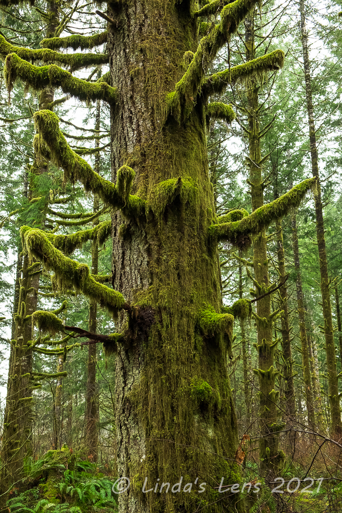


Huge mossy tree


There's wonderful trail in Oregon's Coast Range that follows the Wilson River.  A total of 20.6 miles in length, frequent trailheads provide multiple access points to allow for shorter section hikes.  I've trekked a small portion of this trail, and so far my favorite part has been the section from Jones Creek Day Use Area to the Footbridge Trailhead.  I suggested to hubby that we head there.


Spooky forest


The sky was dripping precipitation when I parked at the Jones Creek Trailhead.  Donning raingear hubby and I set out into the wonderful mossy forest of the Coast Range.  Here the trail followed the Wilson River, flowing furiously after an overnight rainstorm.  Lined by lots of grand fir trees, mossy rocks, and ferns it was a lovely sight.  

However, we'd only covered a half mile when we encountered our first roadblock.  A construction fence was strung across the trail - apparently a nearby bridge was out.


There's the bridge!


What to do?  Lucky for us, the closure notice attached to the fence also included a map of nearby trails.  It appeared the downed bridge could be bypassed by hiking through nearby Jones Creek Campground and rejoining the Wilson River Trail on the other side.  It added a half mile or so to the daily total, but since our goal was to get steps, it was no biggie. 


Side creek crossing


So hubby and I navigated our way through the closed Jones Creek Campground, making a couple of wrong turns before finding the correct connector trail.  This path wound through a beautiful forest full of mossy old trees and huge green ferns.  I kept finding so many photo subjects it took me awhile to cover the extra half mile distance.  But it was so pretty I was glad for the detour.


More wonderful mossy trees


After crossing a side creek on a sturdy bridge (that was very much intact) we rejoined the Wilson River Trail.  Passing by a huge suspension bridge over the mighty Wilson, we briefly considered walking across to visit the Tillamook Forest Learning Center on the opposite shore.  But a sign indicated it was closed due to COVID so we continued on.


Fairy tale forest


This section of trail followed the Wilson near river level.  I enjoyed glimpsing it's blue-gray waters between mossy tree trunks.  Hubby noticed a few fisherman scattered along the banks, all vying for winter steelhead. 

And yahoo - the intermittent sprinkles that had fallen off and on since we'd started our hike finally let up.  It was nice to finally hike with my hood down.


Wilson River framed by mossy trees


I made frequent stops to photograph the amazing scenery, especially the mossy trees.  With leaves absent from the branches, the brilliant green moss really stood out.  Some trees were absolutely coated with the stuff.


These trees had tiny branches


Some of the trees had tiny nubs for branches, each with a tuft of moss attached.


The mighty Wilson


Another mile down the trail hubby and I ran into another closure notice.  This one mentioned downed tree removal and trail repair work a short distance ahead and to detour onto the adjacent powerline road.  Since it was a weekend, I didn't think any work was happening, and told hubby we should just keep going.


Detour on a powerline road


But.....only a short distance later we came upon another fence blocking the trail.  It appeared we could easily slip around this obstacle, and it was tempting to ignore the sign and keep going.  But my law-abiding hubby said we probably shouldn't (also the sign also mentioned a stiff fine for noncompliance).  Not willing to backtrack the entire way, we ended up bushwhacking through the forest to reach the powerline road.


Back to the riverside trail


After crashing through brush and ferns, it was nice to walk on a level gravel road.  Luckily, the detour wasn't too far of a distance and before we knew it another sign directed us back to the Wilson River Trail.


Moss close-up


I'd mentioned to hubby that this portion of the trail was relatively flat.  However, after a couple of miles, the trail began to climb quite a bit - a fact that I'd obviously forgotten.


Trail lined by mossy rocks


The path zigged and zagged uphill until we were looking down on the Wilson River, far below.


Another river view


But all that climbing did give us great views.  Not only of the Wilson River, we also passed by a nice waterfall.  It was named - you guessed it - Wilson River Falls.


Wilson River Falls

The waterfall was near the trail's high point, so once we passed by this cascade, the trail began switchbacking downhill to eventually reach the Footbridge Trailhead on the banks of the Wilson.


Taking in the lush forest


My hubby's knees aren't fond of downhill grades, and the steep downhill in combination with some extremely slippery mud made him extra cautious.  We traveled a short distance gingerly stepping over the muddy track.  It didn't seem to be getting any better the lower we descended.  Afraid of wrenching a knee, hubby asked if we could turn around early.


Wilson River's emerald waters

Since the detours had added some mileage to our day I was fine with cutting our trek short.  Besides, the sky was darkening once again, and I knew it was only a matter of time before the afternoon's predicted showers would start up.


Mega-mossy forest

Retracing our steps we climbed back to the waterfall, then downhill to near the river level once again.


Fog in the woods


Thus far, we'd only encountered a half dozen people, all of them fisherman.  But past the waterfall climb, hubby and I began to meet a couple of hiking parties traveling in the opposite direction.  Still it was nothing like the crowds of hikers we would've encountered at some of the more popular Coast Range trailheads (or in the Columbia River Gorge).


Hubby watching the fishermen

At one place where the trail gave particularly nice views of the Wilson River, hubby and I stopped and took in the beauty of the aqua-green water.  We watched a couple fishermen on the opposite banks casting for steelhead.


Steelhead fishermen

Then we meandered back down the trail, past the suspension bridge, until we reached the final trail detour.  Winding through the beautiful mossy forest once again, I couldn't help but take just a few more photographs, despite droplets beginning to fall from the sky.  Back at the campground, I took a quick potty break at a very stinky pit toilet (but luckily it was open - and even had tp!).  After my little break I noticed this very cute building in the campground with trees carved into it's door.  I think it served as a woodshed for the campground.


Cute woodshed at Jones Creek Campground


From the campground it was a quick (very quick because it was now full-on raining) back to the parking area and hubby's truck.

Driving home, we passed by overflowing trailheads at Elk and King Mountains.  Cars lined the highway on both sides.  I remarked how lucky we were to have had such an empty trail where we hiked.  Encountering less than a dozen hikers, I decided we'd chosen well for our trek.  Not only that, we'd succeeded in meeting hubby's step quota for the day. 


Friday, February 19, 2021

Frog Lake Butte

Last year my friend Catherine and I hiked a loop around Frog Lake, over a ridge separating Frog and Lower Twin Lakes, and returned on the PCT.  (See post here)  I enjoyed myself so much that this year I plotted a return trip. 


Sunrise colors at White River Snopark


But first, how about another sunrise?  After being skunked by fog at nearby White River Snopark a few weeks before, I decided to add a sunrise capture to the day's itinerary.  While it meant pulling myself out of bed ungodly early on a cold, dark winter morning and driving on icy roads, I persevered and got myself in place before sunup.


Alpenglow on Mt Hood


I'm happy to report this time my quest to capture sunrise was wildly successful!  No fog to be found anywhere.


Sunrise, White River Snopark


I watched in awe as the eastern sky erupted in a blaze of colors.  Then as the sun emerged, the top of Mt Hood glowed with stunning pink light.  After filling my memory card with a couple hundred images, it was time to drive up the highway to Frog Lake Snopark, the start of today's adventure.


Mt Hood from Frog Lake


As was the case with last year's trek, the lack of fresh snow made me decide to leave my snowshoes in the car and head out with microspikes.  What little snowpack remained had been frozen and thawed so many times it was reduced to an icy mess.


Mt Hood close-up


Not deterred by the crunchy ice, I clomped down the closed Forest Service road towards Frog Lake.  Taking a spur towards the day use area, I arrived at the frozen lakshore.  From last year's experience I knew that the lake's southern end had a wonderful view of Mt Hood.  


Frozen Frog Lake


Clear skies made for good views of my favorite mountain!  Hood was even wearing her cloudy cap that day.


Icy trail to Frog Lake Butte


After circling Frog Lake and wandering through the campground, I began searching for the trail to Frog Lake Butte.  My memory from last year wasn't as good as I thought, and it took a few out-and-back walks along the campground road, plus frequent glimpses at my gps, before said trail was finally located (and, by the way, the sign had been taken down which added to the difficulty of finding it).


Trail junction


Last year's trip on this trail had been a delightful trek through powdery snow.  Today.....not so much. What little snow remained was mostly dirty ice, littered with tree needles, moss and pine cones.   I also remembered this next leg climbed steeply uphill, an unexpected and unwelcome slog that didn't register fondly in my memory bank.  But, telling myself uphill hiking was good for me, I put my head down and covered the 1.5 miles to the next trail junction surprisingly quickly.


Sign selfie


Decision time - should I continue the half mile further uphill to the top of Frog Lake Butte?  Last year, wiped out by the unexpected climb to this trail junction I'd opted to head back downhill towards Lower Twin Lake.  But skipping the summit side trip left me wondering what I'd missed.  Today, feeling strong and confident I decided to go for the top!


I was disappointed to see a cell tower on top of Frog Lake Butte!


Ugh, this trail was steep!  Although I'd noticed the contours and calculated the elevation gain from my map, it was one thing to see it on paper but yet another to actually do the climb.  I followed a well worn track through the snow as it wound through thick woods, with a couple teaser glimpses of Mt Hood through the trees.  Just when I thought I'd never make it to the top, the trees thinned out and my trail flattened.  Snowmobile tracks were everywhere, meandering through the crusty snow.  I followed a well-traveled track to the summit proper.  And...once on top I was disappointed not to see any mountain views, only an ugly cell phone tower.


Killer Mt Hood view on Frog Lake Butte


I'd heard one could see Mt Hood from Frog Lake Butte's summit.  Maybe the viewpoint was nearby?  From the cell phone tower, several snowmobile tracks led into the woods.  Choosing one of the more packed down tracks I began following it.  After a couple of false starts, I finally found the track that led me to an overlook with a killer view of the mountain.


Wonderful lunch spot on Frog Lake Butte


Yeah - success!  By now I was famished and settled myself in the snow for a well-earned lunch break.


Rough trail to Lower Twin Lake


Although it felt good to sit and fill my belly the air temperature here was much colder than in the forest.  Even thorough I was bundled up in my down coat I became chilled by inactivity and had to cut my lunch break short.  Time to get moving again.


Lower Twin Lake


The downhill trek back went much faster (with less effort) and I reached the trail junction in record time.  Continuing my descent I took the tromped-down path through the woods leading to Lower Twin Lake.  Although only 1.5 miles in length, this leg of my journey seemed to take much longer.  The going was rough, navigating bumpy snow thawed and refrozen, and sunken tree wells.  Sometimes it was difficult to locate the trail, but luckily someone had painted red blazes on the trees providing a marker to follow.


Well hello there!


Finally I glimpsed Lower Twin Lake's frozen surface through the forest.  Yahoo!  Time for a snack break.

The other thing I remembered from last year's hike - Lower Twin Lake is full of very hungry Gray Jays, only too happy to steal your lunch.  I'd been seated just for a couple of minutes when I noticed half a dozen of these birds already perched in a tree directly above my head.  I had to watch my food closely.  If I looked away for a second, one of them would swoop in and try to grab a bite.


Trying to snatch my snack


But it was fun to watch the Gray Jay's antics.  And I had a good time trying to get a few photos of them. They had such expressive faces!  

(And no, I didn't give the birds any of my snacks.  The reason these Gray Jays are so aggressive is due to people sharing food with them.  These birds have become dependent upon humans and don't forage for themselves.  Please keep wild animals wild - don't feed them!)


Giving me the stink eye


After a fun break at Lower Twin Lake it was time for the final leg of today's hiking adventure.  The trail climbed out of the lake's basin until connecting to the Pacific Crest Trail.  From there it was a quick mile back to the snopark and my car.  

Although I missed last year's fluffy fresh snow it was still a fun day out in the winter woods, discovering a new viewpoint on top of Frog Lake Butte and teasing the pesky Gray Jays.


Tuesday, February 16, 2021

Another Winter Sunrise

You might be sick of my sunrise pics - but this one's too good not to share.  

Back in mid-January, while driving to Mt Hood for a day of skiing, I mentioned to my friend that Jonsrud Viewpoint, just outside of the town of Sandy was a fabulous place to catch sunrise. 


Sunrise at Jonsrud Viewpoint
 

My friend remarked he'd never been to said viewpoint.  As a  matter of fact, he didn't even know where it was located.


Colorful sky


As we began to drive through Sandy, I noticed the sky starting to turn colors.  The clouds were also looking interesting.  Seeing the beginnings of what looked to be an amazing sunrise, I turned the car around and headed straight to the viewpoint.


The Sandy River below Mt Hood


Great decision!  Not only did my friend get to see this wonderful overlook, the sunrise was definitely memorable.


Amazing clouds!


A great beginning to a wonderful day of skiing on my favorite mountain.


Sunday, February 7, 2021

Skiing in the Time of COVID

Last year's ski season ended abruptly in mid-March when COVID cases began to rise throughout Oregon.  For awhile, I wasn't sure there would even be a ski season in 2021.  But as snow covered the mountains in mid November, I was happy to see the local ski resorts begin to announce their reopening plans.


Beautiful morning on the mountain!


In December I made three trips to two local ski resorts.  It was great to be out enjoying the snowy mountains.  In January, although the Thursday ski bus was cancelled (I wouldn't have ridden it anyway) one of my friends and I decided to drive up ourselves every week.


Mt Hood emerging from the clouds


Of course with the pandemic still very much active, resort skiing in the time of COVID has been a bit different.  But since most snowriders normally cover up most of their bodies to participate, it's much easier to be protected than with other activities.


Yes, we are smiling for the camera
 

The biggest adjustment?  Keeping my nose covered.  The resorts now require all guests to keep their nose and mouth covered when in lift lines and riding the chairlift.  I've always worn a neck gaiter pulled up over my mouth when skiing, mostly to keep my neck and chin warm.  But now I've had to tuck the gaiter under my goggles to cover both nose and mouth.  And this causes my glasses to fog under the goggles.  It's been a lot of trial and error to find ways to keep things defogged.  I haven't yet found the silver bullet.

The upside to keeping my face fully covered?  No need for sunscreen anymore!  Although, it does make for some interesting selfies.  (Yes my friend and I are smiling under our masks!)


Snowy scenery


And on those chilly days it is much warmer to have my entire face covered.  (If I could only solve the darn fogging problem.....)


Glen tries the ski jump!


Besides the face covering requirement, the other big change is not being able to go indoors.  My local ski resort has kept the lodges open for restroom access only.  So that has meant eating lunch and warming up must be done in the car.


Good mountain views everywhere


Luckily the first few days I've skied the weather has been nice enough to sit outside for lunch.  Instead of the lodge being packed, the parking lot is now full of people at noontime.  And people have gotten creative with their lunch menus.  I've witnessed someone using a camp stove behind their car to warm chili, a grill or two cooking burgers and hot dogs, and even one party who unloaded table, chairs, fancy tablecloth, and set up a full spread of wine, meat, and cheese.


Frosty foothills


Of course not everyone is happy with the mask mandate, and my local ski resort has had to get tough with people who don't comply.  I feel sorry for the lifties who are stuck with the thankless job of having to remind folks to pull up their masks in the lift line.  A virus outbreak would shut down the resort so I'm appreciative of everything the employees are doing to keep people safe.  (Not to mention I don't want to get COVID!)


Admiring late afternoon light on the mountain


The other change for the resorts is they are no longer filling up each chair on the lift.  If you want to ride by yourself, it's allowed.  You can ride the lift with the people in your party but if the chair isn't full you won't be asked to take on additional singles.  That does make the lines move slower, especially during busy weekend days.  But since I'm now retired I can ski on the weekdays.  There's a lot less people than the weekends and lift lines are normally short or nonexistent.


Skiing towards Shooting Star lift


To limit the number of people on the slopes at one time, some ski areas are limiting day ticket sales.  One has to purchase their lift ticket in advance.  Others require a pass to park at the resort.  So skiing is no longer a spur of the moment activity - it now takes a bit of planning.  Luckily at my local ski hill, season pass holders (like me!) are not required to make reservations for tickets or parking.  And on weekdays, crowds haven't been a problem.


Views from the Cascade lift

Since January began, I've averaged at least one day a week of skiing.  It's so wonderful to be back playing in the snow and gazing at views of our beautiful home mountain.

Mt Hood I've missed your snowy slopes!


Interesting clouds over Mt Hood


Despite the changes, I'm happy to be back skiing at my local resort.  In my opinion, covering the nose and mouth, eating in my car, and waiting a little bit longer to ride the lift are small prices to pay for having a ski season this year.