
The one hike I didn't do last year and regretted - the Burroughs Mountain Loop. My hiking book described it as a "trail between earth and heaven." Blogger buddy Richard, author of the blog Richard Hikes glowingly called it "a magical hike so transcendent it stands well apart from the rest" and on a scale of 1 to 10 rated it a least a 57. With such high praise, Burroughs Mountain became numero uno on my Mt Rainier NP "must hike" list.
 |
| Mt Rainier and White River from Glacier Basin Trail |
Nothing, not even an aching toe, unhappy from the nine miles I'd covered the prior day, was gonna stop me from traversing this spectacular trail. (That's what ibuprofen is for)
 |
| Little Tahoma Peak |
Many routes access the Burroughs Mountain's high alpine tundra. One can drive up to Sunrise Lodge and hike from the parking lot (a mere 5 miles round trip and 1200 feet elevation gain), one can start from Sunrise Point (which tacks on an additional 5 miles and 1000 feet of climbing), or take the route I did - begin this trek from the White River Campground (which clocked in at a grand total of 11 miles and 3000 feet elevation gain). Yeah, I like to do things the hard way.
 |
| Monkeyflowers |
But it started so easy. All I had to do was walk a few hundred feet from my campsite to access the Glacier Basin Trail, my journey's first leg.
 |
| Lots of crevasses in this snowfield! |
The Glacier Basin Trail began on a miner's old wagon road. Paralleling the White River, it gently climbed through forest. At the one mile mark, the trees cleared to give hikers a marvelous view of Mt Rainier and the White River's gravelly channel. Little Tahoma, the pointy peak to Rainier's east was front and center, it's white glaciers gleaming in the early morning sun. Zooming in, I spotted numerous crevasses in the adjacent snowfields.
 |
| Lovely flower-filled alpine meadow (xt) |
From the viewpoint it was another 2.5 miles of following the Glacier Basin Trail, continuing to climb through alternating forest and low bushy creek crossings. Not much for wildflowers, save for an occasional patch of vibrant pink monkeyflowers.
 |
| Stunning field of asters |
Although I'd been gradually gaining elevation the entire time, it wasn't until I met up with the Burroughs Mountain Trail that the real climbing began. A tough two uphill miles, ascending nearly 2000 feet, it led hikers from the valley floor to the top of Second Burroughs Mtn. The only saving grace was a fantastic midway meadow full of pink and purple asters.
 |
| Loved the pink ones |
And the views of Mt Rainier were constant and impressive.
 |
| My "Sound of Music" moment |
A gorgeous, sunny blue-sky day, lovely mountain range lining the sky, and a verdant green meadow full of wildflowers. Despite the tough uphill march, life was pretty good!
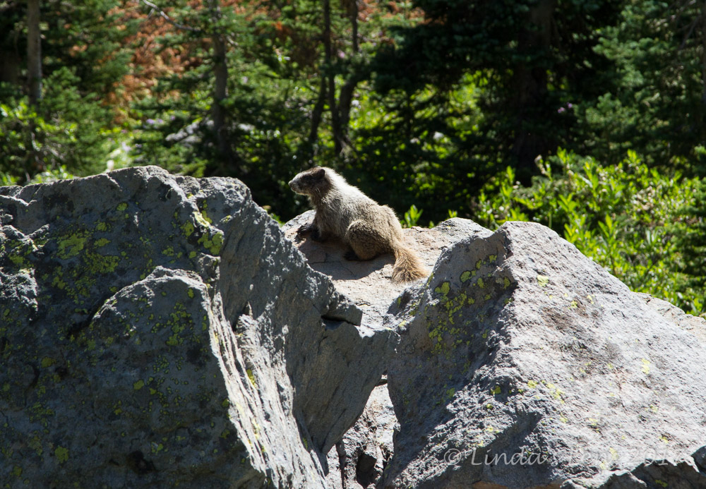 |
| Marmot! |
As I climbed higher in elevation, the surroundings switched from forest to open, rocky tundra. Passing through a rock garden I was startled by a series of very loud high-pitched whistles. Nearly made me jump out of my skin! I stopped for a moment to locate the source, and a large marmot crawled out of a crevice and onto a nearby boulder.
 |
| As close as he'd let me get |
A marmot! It had been years since I'd seen one in the wild. Excited, I zoomed my camera lens as close as it would go, trying to get some good shots of the furry rodent. Unfortunately, the harsh midday light didn't help my photographic endeavors, nor did my attempts to get closer to Mr. Marmot. Every time I moved, he'd dive back into the rocks. By accident, I discovered if I was patient and waited a couple of minutes, he'd always pop back out. But finally, I moved too close for comfort, and the marmot sought cover under some bushes. That was the end of that. Still, a very exciting wildlife sighting!
 |
| Lush green meadow |
Beyond the marmot, patchy tundra meadows soon transitioned into a continuous rock slope. No more shade, I sweated under the hot sun, gasping as the trail switchbacked steeply across an endless talus field.
 |
| Lunch view of the grand mountain |
Boy, it felt like I'd been climbing all day! (Well, technically I had so far) I could see a wall of steep cliffs above, and the outline of three peaks towering along the sky. I assumed these were the three Burroughs Mountains. But it didn't seem like I was getting any closer.
 |
| Rockfall near the summit |
Finally, well past the noon hour, I took a break, perching myself on a nearby rockpile. Famished, my meager trail lunch had never tasted so good. While resting, I took in the amazing front-row view of Mt Rainier's upper reaches. The mountain was so close, it filled the sky. Zooming in with my camera gave fantastic glimpses of crinkly snowfields and steep, rocky slopes. I even witnessed a few small rockfalls.
 |
| Hikers heading to Third Burroughs Mtn |
Rest and lunch helped revitalize my flagging body. Energized again, I continued my uphill march through bleak, barren tundra. Although desolate, the silver lining was all the fantastic views opening up the higher I climbed.
 |
| Trail to Third Burroughs |
Finally I reached a saddle, where my trail made a T-intersection with another path. One skinny track stretched west across the bleak landscape, heading up a nearby peak. I spotted several groups of hikers slowly moving uphill. Was this Second Burroughs Mountain?
 |
| Looking back down Glacier Basin Trail |
Turns out the peak to the west was Third Burroughs Mountain (which I'd find out later that evening after consulting my hiking guidebook). The trail to the east switchbacked up yet another steep hill. I could see people sitting on top of this peak, and they didn't look very far away. Although curious about the mountain to the west, it looked like a much longer distance with more elevation gain (and by now I was tired of climbing. I began to think this hike was gonna be uphill both ways) So I opted to go east, and head up what turned out to be the summit of Second Burroughs.
 |
| Mt Fremont Lookout - yesterday's hike |
Now that I was on the main Burroughs Mountain Trail, I found myself in the midst of hiker grand central. After seeing a total of six hikers thus far, it was a shock to encounter group after group of backpack-toting people, heading in both directions.
 |
| Fantastic 360 degree mountain views |
Climbing up the side of Second Burroughs Mountain, I learned right away why this trail was so popular. The views were absolutely amazing! Looking northward, peaks and green valleys spread out towards the horizon. I spotted Mount Fremont Lookout's barren slope, where I'd been just yesterday. To the south, Mt Rainier's massive base filled the sky.
 |
| Top of Second Burroughs Mtn |
After much huffing and puffing, and dodging of hikers, I finally reached the top of 7,400 foot Second Burroughs Mountain. It's rocky summit was packed with people of all shapes and sizes. Some were snacking, others taking photos (I noticed quite a few tourists with selfie sticks), while others were sitting back and enjoying the view. And what a grand view it was!
 |
| Smoke from Norse Peak Fire |
Mt Rainier dominated the southern skyline. All the other peaks and valleys dropped away in every direction. Some great 360 degree panoramas! I even spotted smoke columns from the Norse Peak Fire, burning just east of the park boundary (a few weeks later this same blaze would force a temporary closure of the White River entrance and evacuation of nearby Crystal Mountain Ski resort).
 |
| Trail from Second to First Burroughs |
Due to the crowds of people, I didn't linger long on Second Burroughs. I followed the path snaking down the side of this mountain (Hooray! Finally some downhill!) It then crossed a narrow, rocky ridge before climbing to the top of First Burroughs.
 |
| Berkeley Park |
This path was extremely busy. I found myself in a conga-line of hikers. Every time I stepped off the trail to take a picture, I had to wait for several folks to pass by before I could rejoin. And I found myself leapfrogging a few of the same people multiple times.
 |
| Looking towards top of First Burroughs Mtn |
But - oh was the scenery fantastic! I looked down into the green, alpine meadows of Berkley park. I spotted Frozen Lake, from yesterday's trek. Traversing the ridge, I felt as if I was on top of the world.
 |
| First Burroughs Mtn summit (xt) |
The top of First Burroughs Mountain wasn't quite as spectacular as it's neighbor. It was 100 feet lower in elevation, Mt Rainier was farther away, and there wasn't as much room to sit and rest. Plus, since it sat at a junction of two trails, the mountain became a natural stopping point for most everyone. I didn't linger long here either.
 |
| Fall colors starting to show |
From First Burroughs, I had my choice of two return trails. I could either follow the left hand path to Frozen Lake (where I'd already been) or take the right hand trail to Sunrise Camp. Since the right hand one got me closer to the final leg of my day's journey (the trail back down to White River Campground), it was an easy decision.
 |
| Trail cut into the cliff |
This turned out to be the best part of the day's journey. The trail hugged the very edge of a steep cliff. Oh my, the views from this perch were stupendous! The cliff dropped 2000 feet straight down into the White River Valley. Due to the steep drop-offs, this trail was not for the faint of heart. But I moved slowly, carefully watching my step, and managed just fine.
 |
| Emmons Glacier Moraine |
Of course, there were more stunning views of Mt Rainier and all of it's glaciers. I spotted the rocky moraine of the Emmons Glacier and located the exact point where this glacier's icy wall abruptly ended and the White River began. The White River's tiny white ribbon looked far, far below. Farther downstream, I spied a lovely turquoise glacial lake hidden in the forest. Looking east, I could see the river winding between tall foothills. Somewhere, way down there, was my campground. I had a lot of descending still ahead!
 |
| White River wayyy down below |
For only a mile and a half, this trail seemed to take a long time to finish. By now the midafternoon sun was hot, I was tired, and the steep descent had triggered aches in my injured toe. (Time for more "vitamin I") But finally I climbed down into a lovely green basin, and Sunrise Camp's log cabin and outhouse came into view.
 |
| Turquoise glacial lake |
Hooray! An outhouse! I'd been needing to answer Nature's call for some time, but the side of that rocky cliff provided nowhere to hide. I was so happy to see that little privy, I didn't even care that it was out of tp.
 |
| Outhouse at Sunrise Camp |
From Sunrise Camp, I cruised a scenic 3/4 mile along the Wonderland Trail, passing lovely green alpine basins, and tiny Shadow Lake. A few dark blue gentians were still blooming on it's shores. Finally, the Wonderland Trail veered from this high meadow, and began the final leg of my journey, a steep 2.5 mile descent back to White River Campground.
Since most visitors access Burroughs Mountains from the Sunrise area, when I hit this final leg, I left the crowds behind. It was a relief to have the trail to myself once again. The path quickly dipped back into thick forest (yahoo-shade!) and abruptly rocketed downhill. Having hiked this trail last year, I knew to expect monotonous forest, so I put my head down, and concentrated on putting one foot in front of the other.
 |
| Shadow Lake |
Losing nearly 2000 feet of elevation so quickly isn't a lot of fun (especially if you have a sore toe). I can't begin to tell you how much of a relief it was to see the campground finally come into view. Time for dinner and some cold beers!
 |
| Gentian |
My, oh my, what a day! Those glowing reviews of Burroughs Mountain Trail? I'm happy to say they were all true. A wonderful day in the mountains, and a fantastic adventure. Richard was right - this trail definitely rates a 57!
(On my last post, I had a few people ask how I liked my new Fujifilm XT-1 mirrorless camera. After exclusively using Canon products for two decades, it's been a huge adjustment to try another brand. I've had a steep learning curve trying to figure out where all the controls are located and how they work. That said, I'm liking the smaller, lighter camera body, and the lens (18-55) seems to take sharp images. Since this trip was the first time using my new camera, I don't feel the images I took were quite as good as those taken with my old Canon 7D. But I think this will improve as I become more familiar with the XT-1. In case you're curious, I've marked the captions of the images from my new camera with an "XT" so you can compare.)


