Thursday, July 30, 2020

Table Rock, Ten Years Later

During the pandemic's early days, when most hiking trails were shut down, there was one local area that managed to remain open.  Searching for places to get my outdoor fix, I started seeing social media reports from an area I'd all but forgotten about - the Table Rock Wilderness.

Trillium

Managed by BLM (that is, the Bureau of Land Management) this nearly 6,000 acre wilderness lies in Oregon's Cascade foothills near the town of Molalla.  It's centerpiece is Table Rock, a large basalt "fortress" rising up from the forest, that boasts spectacular views from the summit.  Surrounded by farmlands, this pocket of rugged woods seems out of place.  A long way from most metropolitan  areas, it doesn't see the heavy use as the Gorge, Mt Hood, or the coast.  I'd only visited here once, in 2010.   After hiking to the top of Table Rock and back, I promptly forgot about the place.


Shady forest

But now in 2020, desperate to find open hiking trails, I decided it was high time for a revisit.  So early one Friday in June I wound through farmlands towards Molalla and beyond, followed the Molalla River, and navigated a maze of gravel roads until finally arriving at the trailhead.


Sasquatch?

The trail followed an abandoned road for a mile, until finally turning into the forest.  The road seemed to go on forever, but thick patches of bleeding heart flowers kept me and my camera entertained.  Finally walking through the woods, I hadn't traveled very far when I spotted this etching on a rock in the middle of the trail.  Although I usually don't condone such behavior, the figure made me laugh.  (Is it a ghost - or a Sasquatch?  Who knows?)


Tie-dye trilliums

A mile of climbing through the woods and the trail led out through a clearing across a talus slope.  High cliffs of columnar basalt rose above, the north face of Table Rock.  It's vertical wall was impressive, but I was concentrated on a patch of  lovely pink and white trilliums.  Kind of looked like tie-dye flowers!  (Jerry Garcia would be proud).


Tall rock cliffs

The trail meandered along in the shadow of the cliffs.  It was kind of rough, climbing over large rocks and bushwacking through overgrown bushes. 


No mountain views today

After following the cliffs for a  half mile or so, the trail once again ducked into the woods, and I climbed slowly upward until reaching the base of Table Rock.  Then the real climbing began!


Summit selfie

Although only a half mile from the summit proper this last segment seemed to take forever.  A man and his cute Australian shepherd dog passed me, the first hikers I'd seen so far.  Finally, the path leveled out and I was able to take in some views of the adjacent wooded hills.  Hooray!


Ugly clear-cut views from on top

Unfortunately forests were not the only thing visible from the top of Table Rock.  Ugly bare patches from past clear cut logging operations contrasted starkly with adjacent forests.  Looked like someone had taken a razor to the hillsides.


Indian paintbrush

I meandered along the summit saddle, snapping photos of the lovely flowers gracing the adjacent woods.


Phlox

Almost to the true summit, I came upon the man and his dog on their way down.  I stopped and chatted for a few minutes, and complimented the man on his very cute and well-behaved dog.  Seeing the dog brought back memories of the last time I'd hiked Table Rock.  My dog Bear was in his prime then and happily joined me on this latest adventure.  He loved hiking so much, it made me sad to think he'd been gone four years already.  I realized how much I missed hiking with a furry companion.


The clouds came rolling in

Reaching the summit proper, I sat on a rock and enjoyed my lunch.  Normally several Cascade peaks are visible from the summit, but today's cloudy weather hid them all.  To add insult to injury, during my break the clouds began dropping, further obliterating views of the adjacent hills.


Trail across the top of Table Rock

Although I'd contemplated recreating my 2010 hike and taking a side trail over to Rooster Rock, in the end I decided Table Rock was enough of a goal for the day, and retraced my steps back downhill towards the trailhead.


Wild onion (I think)

This gave me extra time to photograph some of the pretty flowers on the return trip.


Interesting fuzzy leaves

These fuzzy new leaves were interesting.


Stonecrop, ready to sprout flowers

As were these intricate leaves that I believe were stonecrop, ready to sprout their yellow flowers.


Fairy bells

Delicate, ivory fairy bells also bloomed along the trail.  Although there were many wildflowers in bloom, I was a couple weeks too early for the rhododendrons, which in season are rumored to put on a nice show.


The trail went right by the cliffs

Returning to the cliff section once again, I took some time to try and capture the unusual columnar rocks that made up this side of Table Rock.


Unusual rock columns

Formed by several ancient lava flows, the rock columns showcase these different formations.


Another view of the rock formations

The talus slope at the foot of these cliffs has been created by rock layers splintering off the cliffs and crashing into the valley below.


Salmonberry flowers

Passing back through this area, I began encountering people hiking in the opposite direction.  One of the few areas with open trails, word had obviously gotten out.


Still a little snow left!

Happy to have had the summit nearly to myself, getting up early really does pay!


One last view before entering the woods

I hiked a side path through some trees to get one final glimpse of the adjacent hills before ducking back into the forest for the final two miles.


Bleeding hearts

Once reaching the road, I was passed by at least six different groups of people all heading up the trail.  Taking my time, I captured the lovely bleeding heart flowers growing thickly here.


Delicate striped flower

I returned to an almost full parking area.  For such an out-of-the way place (it's a long 2 hour drive from Portland) it was surprising to see so many people here on a cloudy Friday afternoon.

But I'd  had a great uncrowded hike and it was nice to return to a long-forgotten wilderness area and relive old memories from the last time I'd been here.

Now - time to hit up a farm stand on the way home for some fresh strawberries!

See the blog post from my 2010 hike here.

Sunday, July 26, 2020

Eightmile Creek Loop

With the local favorite trails even busier than normal, this spring I began to seek out lesser-known places to hike.  Of course, less popular often translates to "longer drive."  That's where I found myself on the last day of May, in my car enduring a 2-hour journey to the latest "new to me" trail on my list - the Eightmile Creek Loop.


Purple flowers ready to open

East of Mt Hood, off of Forest Service Road 44, lies an entire network of trails.  Often overlooked for the spectacular mountain vistas around Mt Hood, some of these trails see more mountain bike traffic than hikers.  Such was the case of Eightmile Creek, but I'd done my research in advance, so knew what to expect.  I'd also read that this area was known for nice spring wildflowers.  The promise of prolific wildflower displays was what drew me here today.


Barren trees

After Forest Service Road 44, I navigated a couple of dusty gravel roads (with one backtracking episode after taking a wrong turn).  Searching the for the Bottle Prairie Trailhead, I totally missed the unsigned turn-off and ended up down the road at Eightmile Campground instead.  Although I could've driven back to my trailhead of choice, I opted to park at the campground and start my hike here.  (The fully-stocked-with-tp trailhead restroom sealed the deal!)


Lupine leaves

At the parking area was a trailhead sign, but it failed to mention which trail.  As I pondered if this was the Eightmile Creek trail, a friendly campground host drove by and confirmed my hunch.  He also informed me that the trail was heavily used by mountain bikers, and they were especially fast down the steep decline from Fivemile Butte.


Vanilla leaf

Although I'd initially wanted to climb steep Fivemile Butte first to see the fire lookout tower, the campground host's words made me change course.  Since this hike was a loop, why not start in the opposite direction and save the steep descent for last?  I'd avoid being plowed by mountain bikes, and it eliminated a steep climb right off the bat. 


Purple anemone

Starting my climb on the lower trail, I was immediately passed by large group of mountain bikers (all giving me very polite "thank yous" for stepping off the trail).  But after that, I had the path to myself for nearly a mile and a half.


Bridge over Eightmile Creek

Being in the mountain's rainshadow, the forests on the east side of Mt Hood consisted of more dry-region Ponderosa pine, hemlock and Western Red Cedar.  Many of the trees lacked needles, their bare branches sticking out like skeleton arms (I'm not sure why).  After crossing Eightmile creek on a wooden bridge, I  climbed steeply until the creek disappeared into a small valley far below the trail.


White anemone

But - oh the flowers!  There were tons of white and purple anemones, vanilla leaf, some lupine, larkspur and yellow violets.  Lots of lens candy.


Lots of downed trees!

Nearing the intersection with Bottle Prairie Trailhead (my intended starting point) I came upon an area with a huge amount of downed trees.  Fallen logs littered the forest floor.  Not sure what happened here, but it looked as though they had been there for some time.


Violet

As I bent down to capture a patch of especially vibrant yellow violets, I was startled by a mountain biker bearing down the trail.  I yelped and quickly jumped out of the way, however, the biker had already slowed down.  I think we both surprised each other.  (And the biker was very nice about our near miss).


Larkspur

The Bottle Prairie trailhead was packed with cars and vans, all sporting bike racks.  No hikers here!  Trying to figure out how I missed this parking area, I realized there wasn't a sign on the main road.  No wonder I'd driven right by.


Lupine

Now for the second part of my journey.  I hiked slightly uphill through a meadow packed with lovely purple larkspur.  Again I was almost run over by a mountain biker while knelt down for a photo (who was very polite and apologetic).  This one was my fault - because I was kneeling the biker didn't see me.  Lesson learned - step off the trail before taking pictures!


Scraggly balsamroot

Then I lapped a friendly family, the first hikers I'd seen all day.  I continued my climb through forests, with occasional flowers brightening the trailside.


Wide open views

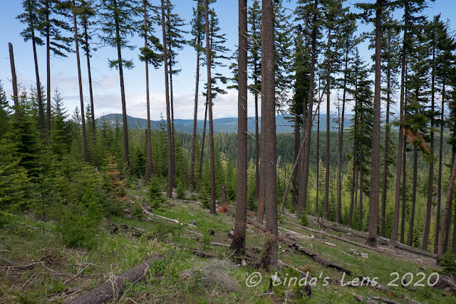
A mile later, the forest cleared and I was treated to some great panoramic views of the adjacent woods and foothills.  Lupine and basalmroot blooms graced these open, grassy slopes.  Having missed the big Gorge flower blooms this spring, due to trails being closed for COVID, it was great to see some of my favorite early season wildflowers.


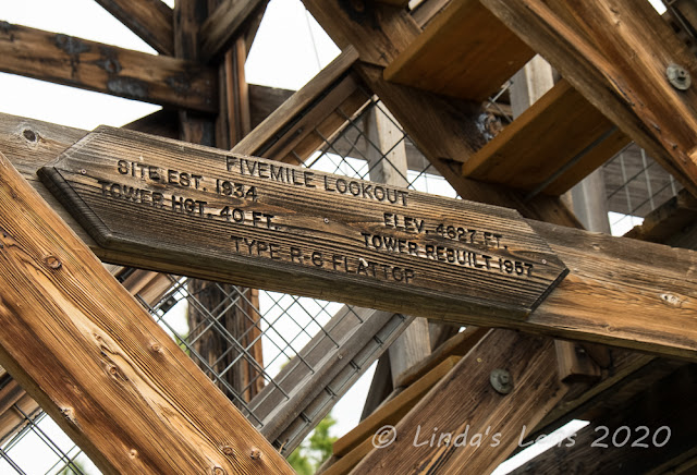
Fivemile Butte lookout tower

I came to an unsigned junction.  According to my gps mileage, the Fivemile Butte Lookout tower was nearby.  This had to be the side trail.  Following the path through thick manzanita bushes, I glimpsed the tower cab through the trees.


Great lunch spot

I love hiking to fire lookout towers.  There's always great views to be had, and the lookout structures themselves are interesting.  This tower had a McGyver-ed basket on a hoist to haul supplies up to the cab.  Although normally rented out for overnight stays, due to the pandemic, the lookout tower was currently closed.  Even the stairs to the top were barricaded.


My lunchtime view

I moseyed around the grounds, past a restroom building until coming upon a huge viewpoint.  A few logs had been placed here, clearly a designated break spot.  Perfect for me, it was high time for lunch!


Another view of the lookout

Although expecting the family I'd passed to arrive soon, I had the fire tower area to myself the entire time.  It wasn't until I was packing up my lunch that the family emerged from the woods.


Basket for hauling supplies up to the tower

So I snapped a few more photos of this historic lookout tower, and was on my way.


On the National Historic Register!


Nice sign with all the stats

After climbing most of the day, it was time for some sweet downhill!  I contoured around the top of Fivemile Butte, taking in more wildflowers and views before the trail began its steep descent.


Stonecrop ready to bloom

I met a few more mountain bikers, some very slowly grinding their way to the top, but others zipping back downhill.  The most stressful part of the hike, I was constantly on guard, listening for descending bikers.


Sunny balsamroot flower

And although all of the mountain bikers I met were very polite, slowing down as they passed me, and thanking me for stepping off the trail, I didn't care much for sharing the trail with them.  I was always worried I wouldn't hear a biker and get hit before I could get out of the way.


More lupine

So my descent was quicker than I would've normally hiked.  There were tons of pretty purple-blue Jacob's Ladder flowers lining the trail, but I only stopped a couple times for photographs.


Indian Paintbrush joins the party

The forest was interesting too.  It appeared this area had been logged at one time - there were tons of small trees growing across Fivemile Butte's steep slopes.


Views on the trail down

Returning to my car, the empty parking area was now full of vehicles, mostly vans with bike racks. Good thing I'd started my hike early!


Jacobs Ladder flowers (I think)

Although my starting point wasn't where I'd initially planned, I was happy with the route I ended up taking.  It was good to get the climbing out of the way first, and visiting the lookout tower later made for a good lunch spot.  Something to look forward to near the end of the hike. 

Another new trail with lovely spring wildflowers, I'll have to return again for fall colors (Rumor has it they are good in this area).  But next time I think I'll pick a weekday to avoid the mountain biking crowd.

7.5 miles, 1400 feet elevation gain.