I'm a self-professed "National Park junkie." Any opportunity to visit someplace holding this lofty designation, and I'm there! So last December, when my hubby suggested we camp at Olympic National Park for 4th of July weekend, I immediately got online and made reservations at Kalaloch Campground.
I've visited Olympic NP twice before, once in 2010 and again in 2014. Our first visit, in September 2010, hubby and I snagged a killer ocean view campsite at Kalaloch Campground. Situated high on a bluff overlooking the mighty Pacific, it was one of our favorite places we've camped ever. Sadly, the days when one could drive up on a whim and snare a campsite are long gone. In 2023, camping at any of the busy NP's requires advance reservations. Some, like Kalaloch, are so popular you have to get online the minute campground reservations become available - in this case 6 months in advance - to secure a spot. (And by the way, Kalaloch is pronounced "clay-lock." Don't even try to use phonics!)
 |
| "Tree of Life" Kalaloch Beach |
Although at the time, six months seemed like an eternity, the chosen weekend rolled around quickly. Hubby and I made the 4 1/2 hour drive north into our neighboring state of Washington, destination the Olympic Peninsula. Although I'd tried for another ocean view campsite, the minute online reservations opened, sites were gobbled up so fast all I could get was one the furthest distance from the beach and adjacent to US 101. I was a bit disappointed with our site, thick tree cover offering no views and the noise from the highway very noticeable. But - it was a holiday weekend, and in the end I realized we were lucky to get anyplace to camp at all.
So hubby and I set up the tent and unloaded our gear. After getting everything shipshape, it was time to stretch our legs with a walk on nearby Kalaloch Beach.
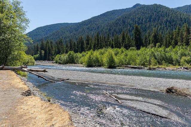
 |
| Wide open spaces - Kalaloch Beach |
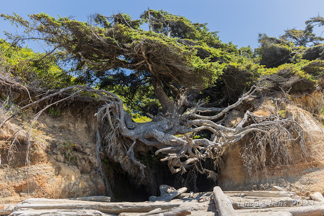
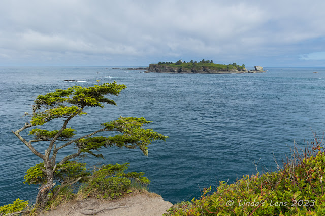
Although not oceanside, it was great to have the beach within walking distance of our campsite. Not far from the beach entrance, hubby and I passed by the famous "Tree of Life," an large wind-blown Sitka spruce whose roots had been drastically undermined by a redirected creek flowing underneath. This poor tree was hanging on by a thread over a large eroded cavern, it's roots totally uncovered. Someday soon the roots will finally give way and the "Tree of Life" will come crashing down onto the beach.
A popular photo site, the place was swarming with people crawling over the roots, up the trunk, and into the void underneath, trying to get that perfect social media selfie. After waiting for several minutes, I was lucky enough to snap a few quick images of the tree sans people before it got mobbed again.
 |
| We found many intact sand dollars |
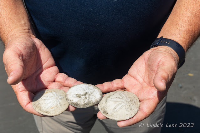
Beyond the "Tree of Life" the beach became less crowded. We enjoyed a long walk to the most northerly end, a tall headland and rocky shore blocking further progress. Hubby found a bunch of intact sand dollars - a rarity on Oregon beaches. We then walked as far south on the beach as we could go. Kalaloch Creek was our turn-around point, flowing wide and deep enough to deter us.
 |
| Ruby Beach, view from parking lot |
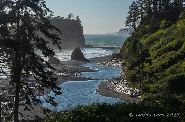
Prior trips to Olympic National Park have familiarized me with the area. From our first visit, I remembered that Ruby Beach wasn't far away. I recalled that it was a lovely place, complete with tall ocean cliffs and picturesque sea stacks. Instead of sand, the beach area is covered with thousands of perfectly rounded stones. Hoping to capture a nice ocean sunset, hubby and I decided to check it out.
 |
| Wave action, Ruby Beach |
Right from the parking lot, Ruby Beach had an overlook that gave great views of the beach below. After taking a few photos from that vantage point, hubby and I took a short downhill path that led to the beach itself.
 |
| Sunset at Ruby Beach |
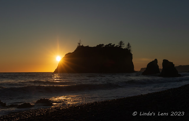
It was a beautiful evening. The sky was clear and the ocean at high tide. Although the tide prevented us from venturing too far towards the sea stacks, I found a good place to set up my tripod while I waited for the sun to drop.
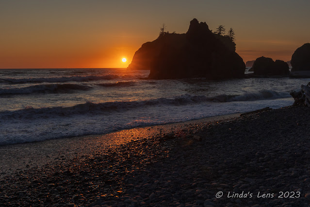 |
| The sun sinks behind a sea stack |
There were a lot of people on Ruby Beach also watching the sunset. I had to keep moving my tripod, as a few clueless folks kept walking in front of my camera. But I finally found a spot free of people just as the sun began to light up the sky. There's nothing better than watching the sun set over the ocean!
 |
| Lingering sky color, Ruby Beach |
The sky continued to glow in beautiful orange hues for several minutes after the sun sank below the horizon. It was still sporting its bright colors as we walked back to the parking lot. I couldn't resist snapping a few more images from the overlook before heading back to our campsite.
 |
| Trailhead at Cape Flattery |
One place in Olympic NP that's long been on my bucket list to visit is Cape Flattery, the most NW point in the lower 48 US states. It's a long drive from most everywhere, but here at Kalaloch Beach it was a mere 2 hours away. The second day of our holiday weekend trip I suggested to hubby that we venture over there and check it out.
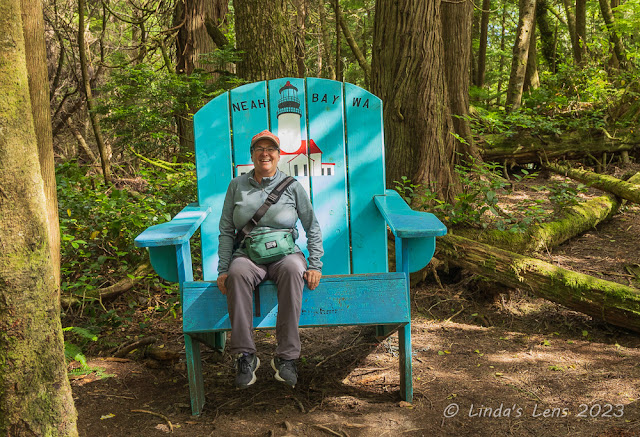 |
| Loved the oversize chair at the trailhead |
Hubby was game to go check out this far-flung destination. We drove northward and then westward, following a twisty road that paralleled the Salish Sea. It was a clear, sunny day and the views were spectacular.
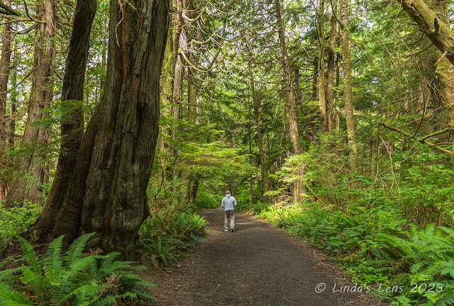 |
| The forest here was beautiful |
Cape Flattery is not technically in Olympic NP, but happens to be on the adjacent Makah Indian Reservation. The tribe requires all visitors purchase a Makah Recreation Pass to park at any trailhead on their reservation. The small town of Neah Bay is where the Makah reservation begins. Upon entering town, we stopped at a convenience store to obtain our permit. Although the pass price was kind of steep ($20!) a helpful store clerk informed me the permit was good for an entire calendar year.
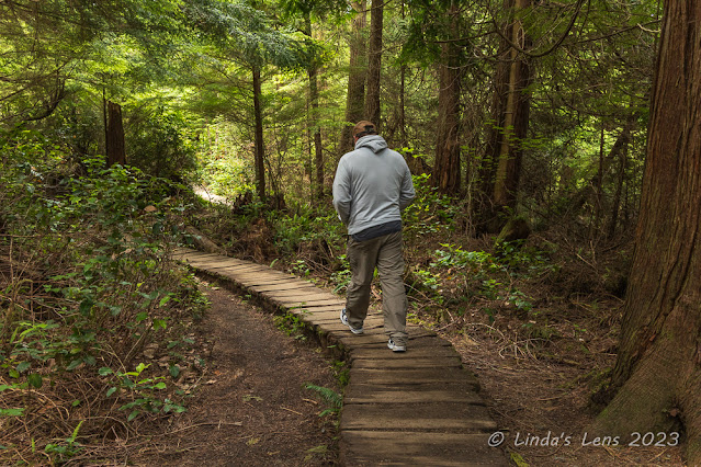 |
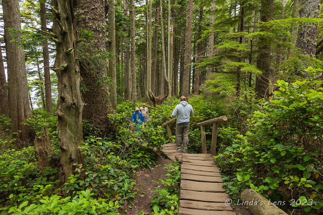
| Lots of wooden boardwalks |
From Neah Bay, hubby drove another 8 miles to the parking area for Cape Flattery. A large sign at the trailhead informed visitors it was a 25 minute walk to the observation deck the end of the peninsula. After a few quick photo ops, hubby and I were off down the trail.
 |
| Almost to the first viewpoint |
We wandered through a beautiful coastal forest, full of large, unusual trees. In some places, wooden walkways had been constructed, and we noticed many benches along the trail. The trail plunged downhill, sometimes rather steeply, and after watching several people slogging by in the opposite direction, I realized we'd have a good climb to look forward to on our return trip.
 |
| Sea stacks at Cape Flattery |
After about a half mile, I could see the forest thinning and blue sky peeking through the gaps. Our trail transitioned onto another wooden walkway. There were quite a few people here, and we had to sometimes step aside to let folks traveling in the opposite direction pass.
 |
| Ocean view at Cape Flattery |
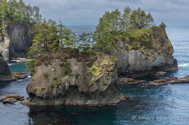
The trail branched out in two directions. Hubby took the right boardwalk and I followed him to an overlook. Oh the view here was marvelous! We could see the jagged, rocky coastline and two large sea stacks, with full size trees on top. The water was a beautiful teal blue. Beyond the sea stacks I could see the open waters of the Pacific Ocean. We'd made it!
 |
| Seascape at the very tip of Cape Flattery |
After soaking in this tremendous sight, and of course lots of photographic documentation, hubby and I retraced our steps back to the trail junction, following the main boardwalk to Cape Flattery's very western end.
 |
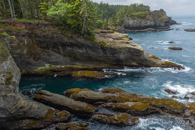
| The coastline was gorgeous! |
There were more views of the ultra-scenic, rugged coastline. Waves crashed upon the rocks and rushed into the tiny coves in between. No sandy beaches here, the forest came right to the end of the rocky headlands.
 |
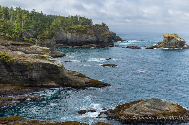
| Small island with a lighthouse directly west of Cape Flattery |
At land's very end, a large observation deck had been constructed. The place was packed with people, all scanning the open ocean. I could see a tiny island a short distance away. There appeared to be a lighthouse on the island. However, most everyone standing on the platform wasn't gawking at the scenery, they were looking for whales. Several people had binoculars and one told my hubby they'd seen a pod of gray whales swimming by the island. After a few minutes, hubby said he'd spotted a whale spouting - but of course, I couldn't find it.
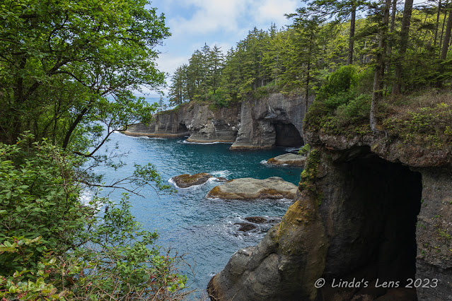 |
| Interesting sea caves |
I had more fun taking pictures of the unique scenery. It was so beautiful! And we'd lucked out with clear, blue skies that made it look even better. On our way back, we stopped at one final overlook that gave us glimpses into several sea caves. Hubby also spotted some birds nesting at the mouth of one cave.
 |
| Beach area at Neah Bay |
After trekking back uphill to the parking lot (which turned out to be not as bad as I'd feared) it was nearing noon, and we were both hungry. Although I'd packed PB&J sandwiches, I was craving the fish and chips I'd seen advertised at a restaurant we'd passed in Neah Bay. It didn't take much convincing my hubby to change our plans. The fish and chips place was right on the water, and we enjoyed the great views while waiting for our food.
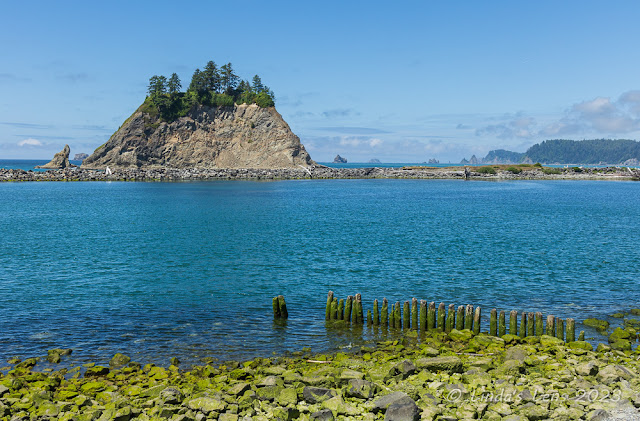 |
| First Beach |
After spending our morning at Cape Flattery, hubby and I retraced our route back towards Kalaloch Beach. Passing through the town of Forks, I remembered there were some nice beaches west of here, near the town of La Push, on the Quileute Indian Reservation. Only 15 miles away, we decided to take the side trip.
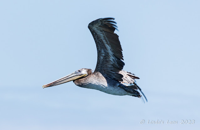 |
| One of many brown pelicans flying by |
The beaches here are unimaginatively named First Beach, Second Beach and Third Beach. We passed by Third Beach's parking area first, and found it cram-packed with cars. Second Beach was just as busy. We finally found ample parking at First Beach, it's location adjacent to the town of La Push the main reason there was more room. First Beach wasn't very interesting. It had a rocky shoreline and only one large seastack. I did spot a flock of brown pelicans flying by, and managed to get a couple of decent action shots.
 |
| Lovely roadside wildflowers |
I'd heard Second and Third Beach were extremely scenic, so was disappointed we couldn't find a place to park and visit them. That's what you get for visiting this area on a holiday weekend, I guess. The consolation prize was passing a large meadow full of colorful wildflowers on our way back to the campground.
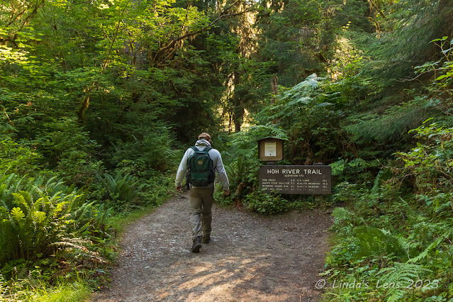 |
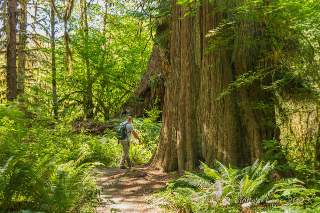
| Beginning of the Hoh River Trail |
The most popular place in Olympic National Park is the Hoh Rainforest. One of the largest temperate rainforests in the US, the Hoh is home to enormous trees, plentiful ferns, and a large concentration of mosses. During our 2010 Olympic trip, hubby and I had done some hiking in the Hoh. On day three, hubby and I decided to pay this place a return visit.
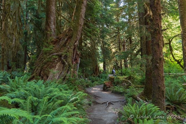 |
| Lots of ferns and gigantic trees |
As with everything nowadays in Olympic National Park, the Hoh draws a large number of visitors. Since it was a holiday weekend, hubby and I decided to get an early start to ensure we'd get a parking place. Arriving at the entrance booth by 8 am, there were already four cars ahead of us in line and we had to wait about 10 minutes before the ranger let us through. Reaching the visitor center, we discovered the undersized parking area was already full. So hubby followed the lead of several other vehicles that had parked along the road. It appeared the roadside parking spots were going fast, so we were thankful that we'd risen early.
 |
| Hubby admires a huge nurse log |
The main hiking trail through this rainforest is the Hoh River Trail. Following the Hoh River, this path wanders through spectacular old growth forests for 18.5 miles before ending at the Blue Glacier Moraine looking up at Mt. Olympus. Day hikers can follow this trail as far as desired and it's also very popular with backpackers. Today's plan was to hike a portion of the Hoh River Trail.
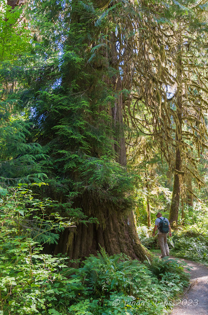 |
| Great-grandpa tree! |
Starting out on the Hoh River Trail, it wasn't long before we passed by our first enormous tree. Due to the area's abundant rainfall, super-sized versions of Sitka Spruce, Red Cedar, Big Leaf Maple and Douglas Fir all thrive here. Huge patches of ferns covered the forest floor, and moss dripped from tree branches.
 |
| Our lunch spot by the Hoh River |
When we'd hiked this trail 13 years ago, it had rained and misted the entire time. The forest was luxuriant with all the vegetation verdantly green. However, today the weather was unusually hot and dry. The Pacific NW hadn't had any measurable rain for nearly two months. I could tell the rainforest was suffering from this lack of moisture. The trail was dusty, many of the leaves were turning brown, and the forest didn't seem quite as lush as it had on our last visit. Even the moss looked dry. It was sad to see this beautiful rainforest looking so parched.
 |
| Another enormous cedar tree |
While hiking the Hoh we met a large number of backpackers, several heading to place called 5 Mile Island camp. Hubby and I decided to make this our day's destination. It seemed to take forever to get to this place, but finally a side trail directed us to a beautiful riverside camping area. We sat on a log with a nice view of the Hoh River and enjoyed our PB&J sandwiches. Once lunch was completed, we turned around and retraced our steps for five miles back to the trailhead. It was a hot day and I was wiped out after completing the entire 10 mile distance. We decided to make a side trip over to Forks for ice cream.
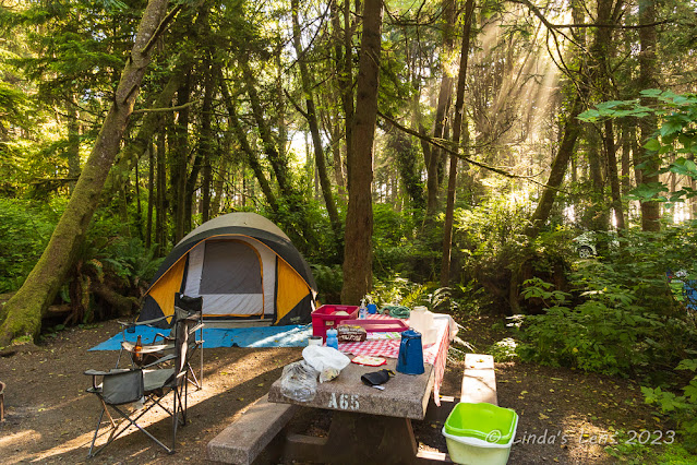 |
| Our campsite at Kalaloch Campground |
But first we had to get out of the park. Upon returning to the truck, we found the parking lot overflowing and the entrance road lined with cars, some parked in areas that weren't large enough to hold vehicles. Passing by the entrance booth, I noticed a huge line of cars in the opposite direction that extended far down the road. The backup went on for several miles. Due to the lack of parking spaces, apparently the park staff would only let a car into the visitor center area if they saw one leave. Some of those people looked like they'd been waiting for a long time. Hubby and I agreed most of those vehicles were probably not going to make it into the park that day.
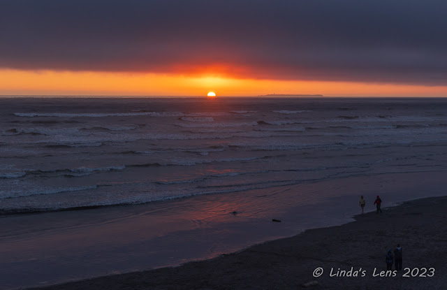 |
| Sunset over the Pacific at Kalaloch Beach |
After getting ice cream from the very busy town of Forks (they were having a 4th of July celebration that day and the place was packed) hubby and I headed back to our campsite. Although it was over 80 degrees outside, the thick tree canopy surrounding our site kept temperatures downright chilly. As a matter of fact, I had walk out into the open to warm up! I made a trip to the beach for sunset that night, and it didn't disappoint.
 |
| Foggy morning at Ruby Beach |
The fourth and final morning it was time to head home. After packing up our campsite, hubby and I decided to make one last trip over to Ruby Beach. It was low tide and we wanted to see what the beach looked like when it wasn't inundated with water.
 |
| The fog made for some neat images |
The morning was extremely foggy. At first I was disappointed. But then I realized that fog makes for some cool photographic effects.
 |
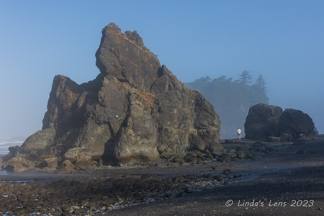
| Low tide made this sea stack accessible |
I love visiting beaches at low tide. The largest seastack was now accessible, so we walked out to its base to explore the surrounding tidepools.
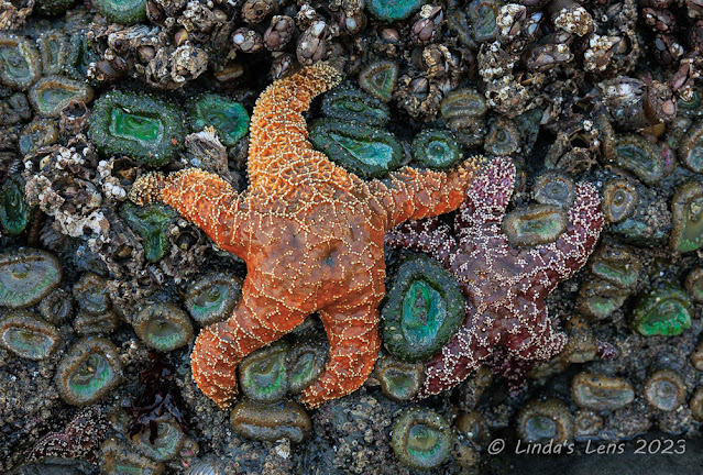 |
| There were many colorful seastars |
I was pleased to find a large number of colorful seastars stuck to the underside of the big seastack.
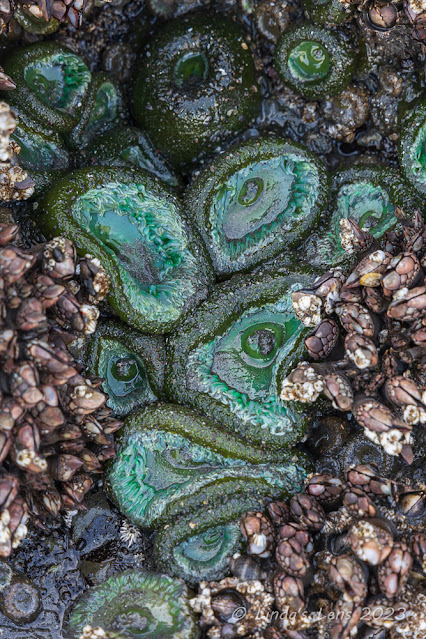 |
| Slimy anemones |
There were also hundreds of slimy anemones. But if I could catch the anemones while still open, they were a lovely shade of greenish-blue.
 |
| I loved this bright purple seastar |
I even found a seastar that was bright purple! So pretty! It was by far my favorite.
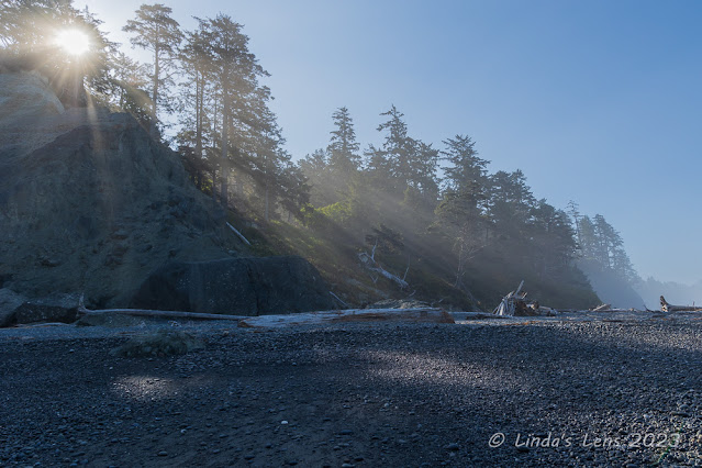 |
| Sun rays streaming through the fog |
Hubby and I explored Ruby Beach for a couple of hours, peeping into tidepools, dodging waves, (and getting our feet absolutely soaked in the process) and admiring the sun's rays as they began to break through the fog.
 |
| Goodbye, Ruby Beach! |
Soon it was time to bid Ruby Beach, and Olympic National Park, a fond farewell. We'd had a great weekend, discovering new places and revisiting old favorites. Watching the waves crash on the beach and capturing stunning sunsets. It had been a wonderful and well-needed getaway. Heading home with wet shoes and a camera full of stunning images, I was thankful for having such an extraordinary National Park just a short drive away.


