Tuesday, September 20, 2022

Last Look at Glacier Bay

 (This is seventh in a series of posts recapping my recent trip to Glacier Bay National Park in southeast Alaska.)

As mentioned in my previous post on the last day of our vacation to Gustavus, Alaska my hubby and I had nearly an entire day to fill.  Our flight home didn't leave Gustavus until 5:30 pm.  So we slept in and enjoyed a leisurely breakfast while discussing how to spend our time.


Hiking the Forest Trail in Glacier Bay NP

The weather, which had been surprisingly cooperative the entire visit, decided to throw us a curve ball on the final day.  We woke up to foggy skies and misty rain.  However, we didn't want to spend nearly an entire day just sitting around our place of lodging, so we asked one of the drivers to take us back to Glacier Bay National Park.


This large mushroom was catching raindrops

Yeah, the weather was soggy but we had raingear!  And we're from the Pacific NW, so rain is not a new thing to us.  Hubby and I decided to explore one the short trails near the National Park Lodge.  Although I'd done a bit of sightseeing here two days ago, this would be his first time seeing the area.


The ultra-mossy forest floor

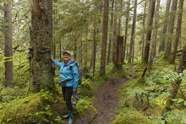
We decided to hike the nearby Forest Trail.  From the National Park Lodge, the Forest Trail was a 1-mile stroll through lush, moss-carpeted woods.  Apparently this forest grew on top of a past glacial moraine.


Lots of lily pads in this pond

The forest here reminded us both of the coastal forests back home in Oregon.  Lots of moss, ferns, and fungi.


Moss close-up

Part of the trail was on a very nice wooden boardwalk.  The boardwalk took us past a series of small ponds, the largest full of lily pads.


Not many wildflowers, but I did find this tiny purple one

After a pleasant one-mile walk, the Forest Trail dumped us out on the rocky coastline of Bartlett Cove.  We could either follow the coast trail back to the lodge, explore the beach, or duck back into the woods and check out the campground.  Since the tide was out, Hubby and I first decided to see if there were any tidepools on the beach.


The rocky beach at low tide

Sadly, no tidepools were found.  The beach was littered with rocks.  We noticed one rock was covered with deep grooves, likely scraped by long-ago glacial activity.  One interesting fact we discovered - with the retreat of the glaciers, the land that was once covered by the weight of several feet of ice is now rising.  This upsurge has added more land area to the properties bordering Glacier Bay.

A bit of moss grew between the rocks normally covered by high tide, so some of them were quite slippery.  And the closer you got to the water the more sticky mud one encountered.  Ugh, this wasn't any fun.  Time to turn around and check out the campground!


The scrapes on this rock may be due to glacial action

Like nearly all U.S. National parks, Glacier Bay provided a large campground for people who enjoy a bit more rustic accommodations.  Since most visitors either arrive via plane or boat, the campground didn't provide much vehicle parking.  So this campground was a series of trails through the mossy understory with side paths to specific numbered sites.  If you chose a site at the very end, it would be a long walk carrying all your camping gear.


Walking through the campground

The other difference at this campground - since there were many bears in the nearby forest, no food storage was allowed at your campsite.  Instead a sturdy wooden building was provided for this very purpose.


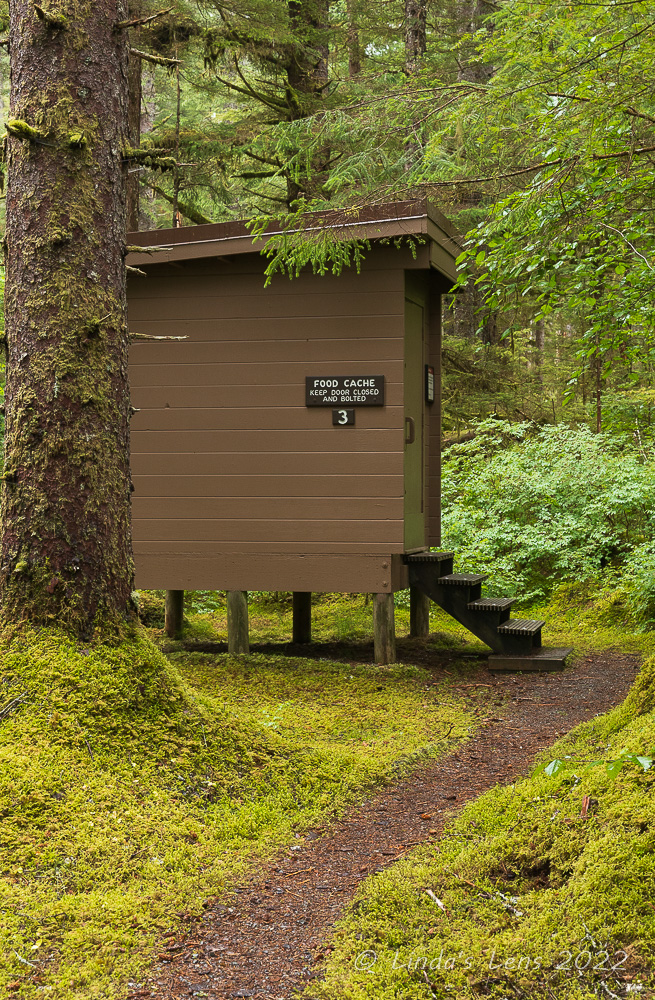
No storing food at your camp!


With the drippy weather, we saw exactly two tents in the campground out of about 30-some campsites. Not very many folks were taking advantage of staying here, even though it was free.  (Not that I blame them, having done it many times I think camping in the rain is a miserable experience.) 


This path was lined with large bushes of Devils club

After reaching the end of the campground, Hubby and I retraced our steps back through the wet, mossy forest.  One path was lined with huge bushes of Devils club, which required a bit of maneuvering to avoid their thorny branches.


Raindrop-jeweled asters

Emerging out of the forest onto the coast path once again, Hubby and I followed it back towards the lodge.  I noticed a small patch of waterlogged asters, their petals bejeweled with raindrops.  We also spied a totem-like figure carved into one of the nearby tree trunks.


Someone had carved a totem into this tree

We still had an hour before our shuttle driver was due to pick us up so I decided to drop in to the ranger station and inquire about hiking another nearby trail that followed the Bartlett River.  When I asked the ranger behind the desk about this trail, his first question was "Do you have bear spray?"  When I replied that we didn't, the ranger proceeded to warn me about a mother bear that had bluff charged a woman on the same trail the previous day.  However, the ranger advised me that as long as I made noise as I hiked, we'd probably be okay.  He explained this gives the bear warning that people are coming, so they can avoid you.  The worst thing a person can do is surprise a bear.


Misty day at the Huna Tribal House

When I told Hubby about the bear situation, he was all for hiking the trail.  He kind of hoped we'd see a bear.  However, I wasn't so sure about that.  I was afraid we'd surprise one and that was the last thing I wanted.  However we decided to head off towards the Bartlett River trail anyway, bear or not.


These totem poles were very tall!


Our path to the Bartlett River trail led us past the Huna Tribal House and I had fun showing Hubby the beautifully decorated building (that sadly wasn't open yet) and the two impressive totem poles standing guard.


Hiking on the Bartlett River Trail

It was about a half mile walk to the trailhead.  As we started out on the Bartlett River trail I was dismayed to see the forest was full of huge bushes, perfect for a bear to hide behind.  Gulp!  As Hubby walked ahead, I took up the rear, trying to keep up a conversation with him.  But my hubby isn't much of a talker and he walks much faster than me.  So when he got farther ahead I began calling out "Hey bear!" periodically.  Let me tell you, yelling "hey bear" gets old fast.  So I started yelling out other things, like "How's it going bear?" and "Don't eat us bear!"  I know I annoyed the heck out of my hubby, but on the plus side we saw zero bears (or any wildlife) for the entire hike.


More "Bears Breath" fungi

The Bartlett River Trail was a 1.7 mile rough path that paralleled the Bartlett River.  But the forest was so thick here I only got one glimpse of the river through the trees.  We'd hoped to hike the entire 1.7 miles, but after a mile of tromping through mud over rocks and tree roots, my plantar fasciitis was acting up big time.  Looking at our watches, we also realized we needed to head back soon if we were to meet our ride in time.  So Hubby and I turned around and retraced our steps back to the lodge.  Good thing we did as we made it with about 15 minutes to spare.


It was a wet, muddy trek!

Back at our lodge, we still had most of the afternoon to entertain ourselves.  By now the rain had paused so I suggested to Hubby that we borrow some bikes and ride the short distance into town.  Gustavus was so small it only had one gas station.  The pumps looked like something from the 1950's.  Perfect photo subjects!


The only gas station in Gustavus

Although it was only about a mile into the "hub" of Gustavus, nearly half of our route was on a bumpy, potholed gravel road.  Made pedaling our well-worn loaner bikes a bit of a challenge.  But once we hit the paved main road it was smooth sailing to the gas station.


I loved these old pumps

The gas station was like opening a time capsule from a bygone era, from the ancient pumps to the old Mobilgas sign.  There were three pumps - one for gasoline, one for diesel fuel, and one for stove oil.  Gas was a whopping $5.89 a gallon and diesel $6.99 a gallon!  Inside the station were more antiques mostly related to filling stations of old. 


"Downtown" Gustavus

Diagonally across the road was a dilapidated strip mall housing a few businesses.  The gas station and this building were all there was to "downtown" Gustavus.  Having taken a good look at the "business district" Hubby and I turned our bikes around and headed back.  Along the way, we passed by a very Alaskan traffic sign.


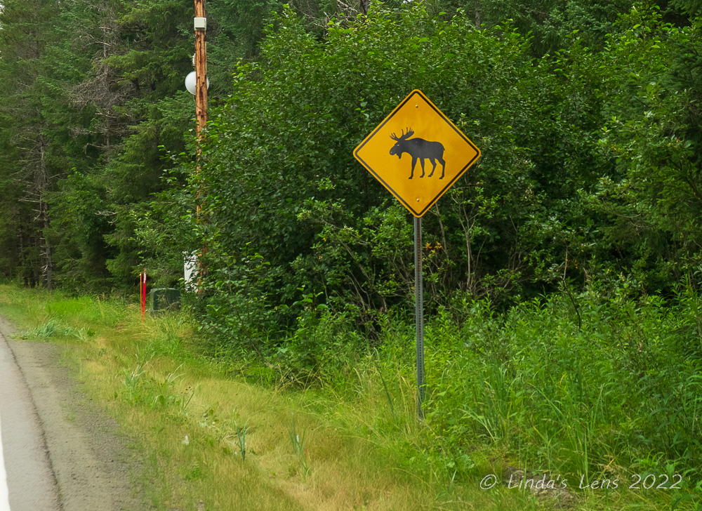
Different road hazards in Alaska

Our trip home was a series of flights from Gustavus, through Juneau, including an overnight stay in the Seattle airport (yes, we were "sleepless in Seattle.")  But it was a wonderful trip.  I checked another National Park off the list!  Hope you've enjoyed all my recaps.  If you've missed any, I've listed all the Alaska blog posts below:


Whale Watching in Alaska

Glacier Bay National Park by Boat

Critters of Glacier Bay National Park

My First Halibut Fishing Trip

Exploring Glacier Bay National Park

Kayaking Icy Strait


Wednesday, September 14, 2022

Kayaking the Icy Strait

 (This is sixth in a series of posts recapping my recent trip to Glacier Bay National Park in southeast Alaska.)

Hubby and I had been halibut fishing, I'd gone whale watching, and we'd both taken the day-long Glacier Bay National Park cruise.  What was next on the agenda?  Our final full day in Gustavus, Alaska a guided kayak tour was planned.  After an excellent kayaking trip during a prior Alaskan visit, I was looking forward to a repeat.


Carrying kayaks to the dock

The kayak tour company picked up hubby and I and another couple from our lodge.  They ferried us to their offices where we met another man and woman who were also part of the day's tour.  After outfitting everyone with waterproof boots, pants, and jackets we loaded into a van with a kayak trailer attached for the very quick trip to the town's public boat dock.


Mountain views in Icy Strait

Again we lucked out weather-wise with another cloudy, but thankfully dry day.  Our guide unloaded the kayaks and had everyone pitch in to carry them to the shoreline, a short distance away.  Then he assigned each person a life jacket and spray skirt.  After shimmying into those, we helped the guide load the kayaks with lunch, water bottles, and emergency supplies.  Then he gathered the group around and demonstrated how to enter and exit the boats, how to paddle, and a few other items I promptly forgot.  But one thing I did remember - our guide told us that when the water got rough, the best thing to do was keep paddling.  This advice would serve me well later.


First a through briefing from our guide

Our route for the day was a crossing of the Icy Strait, the large body of water at the entrance of Glacier Bay.  We'd boat across the strait to Pleasant Island, a large island that was a designated wilderness area.  After landing on the island our guide would give us a short nature hike.  Then we'd have our lunch and paddle back.  When booking this trip I was told the excursion would take a full day.


I think we're ready to do this!

Finally it was time to get into our boats and try things out.  All the kayaks were two-person, so each couple had their own vessel.  Hubby, who is an extremely strong paddler, elected to sit in the rear so he got in first.  Once he was seated with his spray skirt secured, it was my turn.  Let me tell you, that seat is a long ways down!  But I managed to get in without falling into the water or tipping the kayak over, so I considered that a win.  I even was able to stretch my spray skirt across the opening and slip it in place by myself, not an easy feat when you're inside the boat!


Out on the water

Once both hubby and I were in place, our guide pushed us out into the water.  We were off!  Floating in the waters, I tested my paddling techniques.  But I really didn't need to stroke that hard.  My hubby was such a strong paddler he propelled the kayak for both of us.  I joked he was my outboard motor.


Our group paddling together

Of course I brought my cameras along for the voyage.  Not wanting to wreck my "better" camera, it was secure in a dry bag by my feet.  But I'd slid my old point-n-shoot Canon into another dry bag which was strapped into the kayak's top webbing for easy access.  Since Hubby was managing to control the kayak just fine, I took the opportunity to get shots of our progress.


I got hubby to quit paddling long enough for a photo!

The water was smooth, so we made it to the middle of Icy Strait in no time.  It was great to be floating surrounded by great scenery and wildlife.  Cloud-capped mountains rose from the skyline.  I spotted birds and sea otters floating in the water, but they didn't let us get very close.  Not close enough for photos anyway!


Our guide giving instructions

And of course I took the opportunity to photograph both myself and the other boaters in our group.  Gotta document things, after all.  But soon Hubby grew tired of being the only paddler, so I heeded his grumbles and stowed the camera for awhile.


Approaching Pleasant Island

Since our kayak trip was supposed to be all day, I was a bit surprised when we approached the Pleasant Island shoreline and it wasn't even 11 o'clock.  From the opposite shore Icy Strait had looked wide and imposing and I assumed we'd be paddling for a long time before reaching our destination.  I didn't expect that we'd cross so quickly.


We had to paddle through lots of kelp

Our guide steered us around the island, through a huge bed of kelp.  (That was challenging to paddle though.)  He said we'd land on a beach a short distance away.


Almost to the beach

Our tour group floated along the shoreline of Pleasant Island.  I snagged a few more pictures here and there.  Finally our guide  headed for a pebbly beach up ahead.  We all pulled our kayaks on shore and managed to extricate ourselves from the vessels.  Success!  We'd all made the voyage in one piece and only one woman had gotten wet (and it wasn't me).


Taking a break on Pleasant Island

It was still too early for lunch, so our guide suggested a short nature hike to explore a little of Pleasant Island.  After sitting in our vessels, everyone was up for a leg stretcher.


Forest Service cabin on Pleasant Island

As mentioned before, Pleasant Island was a designated wilderness area.  No one lived here, but the locals sometimes boated across the strait to camp and hike.  The Forest Service maintained a cabin near our landing point that could be rented to the public.  Shortly after setting off on our short trek, the guide led us by this cute little building in the woods with a partial view of the water.


Our guide took us on a nature hike

Beyond the cabin, we followed the guide single-file as he thrashed through the thick bushes.  There was a very faint path, barely a trail, leading us through the forest.  I kind of felt like we were bushwhacking - made even more difficult as we were all wearing rubber boots (the official Alaskan footwear.)


Examining a huge blow down tree

This part of Alaska receives a huge amount of yearly rainfall.  Winters are usually more rainy than snowy and the forests here more closely resemble rainforests of the Pacific NW.  All this moisture yields tons of fungi - which our guide pointed out as we slogged along.


Lots of fungi in this forest

There were fungi (mushrooms) of all shapes, colors and sizes.  Of course, I couldn't resist photographing most of them!  At one point, our guide pointed out a huge brown fungi growing like a shelf off of the side of a tree.  When he said the name, I heard "Bears Breath."  I thought, hmm, funny name for a mushroom, but okay.  Come to find out, the name was actually "Bear Bread."  Ooops!  (I still like "Bears Breath" better.)  One thing for sure, now I won't ever forget the name of this particular fungi.


Scrambling under a fallen tree

We walked for about a half mile, bashing through thick bushes, scrambling under downed trees, and hoofing through rocks and tree stumps until we reached the top of Pleasant Island.  The area here was more grassy with less trees.  After pointing out a few of the more interesting plant life, our guide led us back through the forest to the beach.


"Bears Bread" fungi (not "bears breath")

After having nice lunches packed by our lodge most of the week, I was expecting a good spread.  But lunch was disappointing.  Our guide laid out dry bagels, cream cheese, and equally dry smoked salmon.  He cut up one apple and offered a dozen sad-looking carrot sticks.  He'd packed a thermos full of hot water for hot chocolate and tea, but when I tried to drink my tea, I found the water still scalding hot - so hot that it blistered my lower lip.  The only redeeming factor was the wonderful homemade ginger cookies for dessert.  And there was enough of those for seconds (which I of course took advantage of!)


Looking out on Icy Strait from Pleasant Island

After finishing our lunch it wasn't even yet noon.  However, our guide was getting nervous.  He said the tide was starting to come in and the afternoon wind that accompanied it was usually strong.  Worried about navigating the Icy Strait in choppy conditions, he suggested we start back across before things got too bad.


Time to paddle back!

So we all stuffed ourselves back into our respective kayaks and launched into the strait.  Our guide told all three couples to "stay together."  Soon after hitting the water, that advice got thrown out the window.  One couple noticed a spouting whale nearby and paddled closer for a better look.  The other couple, intent on returning, started paddling like their lives depended on it and were soon far ahead.  Hubby, wanting to catch the faster couple, activated his inner motor boat and we were soon in hot pursuit.


One of the other couples in our group

Waters were calm to begin with, but once we rounded the corner of Pleasant Island, our group was met with the full fury of Icy Strait.  The once calm sea was now full of rowdy waves, buffeting our tiny boat.  The wind had definitely picked up strength, and it seemed to be blowing directly at us.  Paddling against the wind and waves slowed our progress to a crawl.  There was no time for photos now, as I needed to paddle as if my life depended upon it (which it kinda did.)  Thankfully I remembered the one vital instruction from our guide this morning "If the water gets rough, the best thing to do is keep paddling."  So I did.  Through all the waves that threatened to overtop the boat, through all the unexpected splashes that got my left arm thoroughly soaked, through the screaming wind that seemed impede all forward motion.  I dug in and paddled until my hands began to get numb and my arms ached.  Still, the Gustavus boat dock didn't look like it was getting any closer.

By now our group was totally strung out across the strait.  Our guide had dropped back to be with the last boat so we other two couples were on our own.  Bit by bit I began to see progress.  The dock slowly inched nearer (albeit very slowly).  Finally, after a very long time, Hubby and I passed the dock and wearily paddled the remaining short distance  to the beach.  Hurrah - we'd made it!


This couple stayed at the same lodge as us

By the time everyone was finally back onshore, it was only 1 o'clock.  What was presented to us as an "all day" kayak trip was already finished and it was barely afternoon.  After packing everything up and returning to our lodge we still had most of the afternoon to fill.

Although it was fun to experience kayaking again, both Hubby and I were not impressed with the guiding company.  Compared to my last Alaskan kayak tour this one was a total bust.  We'd been told this was a "day long" tour, only to be finished shortly after lunch.  We spent at the most about three hours actually on the water, due to tides and wind.  If Icy Strait has a reputation for rough seas, why hadn't the guide company taken us somewhere a bit tamer?  And the sparse lunch, complete with burning-hot water for tea, had left quite a bit to be desired.  We both agreed this was our least favorite activity and one we wouldn't repeat again.

Tomorrow our flight left for home.  But with our departure not until 5:30 pm, Hubby and I still had most of the day to fill.  C'mon back for my final Alaska post - our last look at Glacier Bay.


Thursday, September 8, 2022

Exploring Glacier Bay National Park

(This is fifth in a series of posts recapping my recent trip to Glacier Bay National Park in southeast Alaska.)

After halibut fishing and an amazing whale watching trip, I was itching to explore nearby Glacier Bay National Park.  Checking another US National Park off my list was the main reason I'd chosen to vacation here in Gustavus, Alaska.


Many visitors to GBNP arrive by boat

The whale watching trip was a morning-only cruise, so I had all afternoon to fill.  Hubby was off halibut fishing for a second day so I was on my own.  Luckily the inn where we stayed was willing to drive me the short distance to Glacier Bay National Park HQ.  I jumped at the chance to spend a couple hours exploring the lodge and visitor center.


The large public boat dock

After arriving at the Glacier Bay Lodge parking lot and agreeing on a pickup time with my van driver, I first went inside the lodge to check out the visitor center.  Open limited hours (11 am to 1 pm each day) it had closed shortly after my arrival.  I wasn't able to purchase any souvenirs, but did manage to snag the official park map and newspaper, which I collect from each National Park I visit.


I'm not sure what this other dock was for

Glacier Bay National Park and Preserve is huge - encompassing 3.3 million acres of glaciers, mountains, temperate rainforest, wild coastlines and deep fjords.  Nearly all of the park is wilderness, inaccessible unless one has a private boat, kayak, or floatplane.  Most visitors see the park via the daily glacier cruise (which I did the following day.)  The park headquarters offered a few hiking trails, a campground, a lodge with dining and cabins for rental, a large boat dock, and a tribal house for the local natives.


The people in this boat sailed from Washington state

Since most visitors to this National Park arrive either by boat or plane, Glacier Bay park headquarters has a massive dock for watercraft.  After exiting the lodge, I followed a shoreline path that took me to the dock.  Actually there were two docks - one appeared to be for the general public, with many boats moored here.  The other dock was higher with only one gray boat tied up (that looked like some type of research vessel.)


The official park sign is on the dock

I took a stroll onto the public dock and found the official national park sign.  I was surprised to see it here - most national park entrance signs are placed on the road where you enter the park.  But I guess this makes sense when you realize many visitors arrive here by boat.  While on the dock I met an older couple that had done just that.  Striking up a conversation with the wife, who was holding onto a rope attached to a very large watercraft, the lady told me that she and her husband had sailed here from Seattle.  Taking a boat to Glacier Bay all the way from Seattle!  I was duly impressed.


Glacier Bay Lodge as viewed from the dock

From the dock, I got a nice view of the Glacier Bay Lodge.  It was a stunning building, constructed in a "park service modern" style.  The enormous, asymmetrically pitched roof, with triple triangular dormers gave this building it's unique look.


Totem pole near the public dock

The park also honors the native Alaskans, who were the first people to settle here.  The Tlingit people made their home in Bartlett cove, harvesting salmon from Glacier Bay.


I was fascinated by the detail!


Near the boat dock, a tall totem pole soared skyward.  I was fascinated by the intricate designs carved into the wood.  Later, through online research, I learned this was a healing totem pole, telling the story of the evolving relationship between the National Park Service and the Hoonah Indian Association (the federally recognized tribal government of the Huna Tlingit clans.)


Salmon are an important part of the local native culture

From the Glacier Bay National Park website: "Mixing traditional form line design and modern artistic representations, it depicts the Huna Tlingit’s tragic migration from Glacier Bay Homeland, a painful period of alienation, and more recent collaborative efforts between the tribe and the NPS. The Healing Totem Pole was specifically designed not only to relate the difficult history between NPS and the Huna Tlingit, but also to relay the history of people working to overcome past hurts and heal."


I took dozens of photos of the totem pole

I captured as much of the details as I could from this amazing totem pole.


Another interesting detail

After my totem pole photography session, I followed the path along Bartlett Cove's shoreline.  After a cloudy start, the sun had come out.  I enjoyed the blue skies and fantastic views.


Bartlett Cove shoreline

The path was lined with bushes, many of them full of ripe berries.  There were bright red ones, smaller blue ones (which I discovered were Alaskan blueberries) and orange thimbleberries.  I struck up a conversation with a local man picking berries near the lodge.  He pointed out a thimbleberry and told me to taste it.  The man said it was the best tasting berry - and he was right!


These bright red berries were everywhere

Following the cove shoreline, I came upon another totem pole. 


A second totem pole was outside the Huna Tribal House

This totem pole was next to the Huna Tribal House.  This house was built by the National Park Service as a gathering place where tribal members and park visitors can learn about and preserve Tlingit culture and history.


Huna Tribal House

The house was open so I went inside.  A native woman sat at a table displaying some handmade items for sale.  There were purses and keychains, all very beautiful.  I chatted with the woman for a couple of minutes and complimented her handiwork.  The house itself was impressive with high ceilings, huge wooden beams, and more carving and painting artwork.  The native woman told me the local tribes often hold different ceremonies and celebrations here.


Colorful carvings

Returning back outside, I noticed not one, but two totem poles standing guard outside the Huna Tribal House.


This face is interesting

Again, from online research of the National Parks Service website, I learned that these two totem poles represent the Raven and Eagle clans of the Huna Tlingit.  The website gives a very interesting interpretation of the symbols carved into each of these totem poles.  I wish I would've had this information when I was photographing these!  


This is a bear, part of the Eagle clan

If you are interested, the website can be found here.


Glacier Bay Lodge was beautiful

With my allotted time rapidly drawing to an end, I headed back to Glacier Bay Lodge to meet my ride.


Fireweed in front of the lodge

It had been an interesting afternoon of exploration of this unique national park.  I made plans to return when my hubby wasn't fishing to explore some of the nearby trails.  To be continued...