After spending the better part of two days geyser-viewing, my buddy Kim and I were ready to add some variety to our Yellowstone adventure. So on our second afternoon in the park, we left the Old Faithful area to check out Mammoth Hot Springs.
Well, I should say we tried to leave the Old Faithful area. I didn't even get a chance to exit the on-ramp to the main park road when my car was stopped by a huge traffic jam. Westbound vehicles of all shapes and sizes were at a dead standstill. The road between Old Faithful and Madison junction was under construction and that meant one-way traffic for several miles.
 |
| Buffalo grazing in a field of flowers |
Kim and I sat in the car for over 30 minutes, watching traffic stream by in the opposite direction. Just when I thought we'd be stuck there all day, the cars in front of us began to finally move. We inched through a rough gravel road, past lots of construction equipment. I was never so glad to hit pavement again! But after waiting in a group for so long all the vehicles were bunched up and everyone seemed to stop at the same places. Although we'd planned on seeing the Grand Prismatic Spring, there was so much traffic trying to turn off into an already overflowing parking lot, I ended up just driving on past.
 |
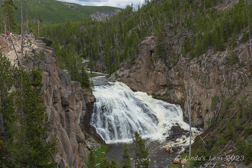
| Unnamed waterfall |
At the Madison Junction, I turned east along a road that followed the Gibbon River. After a brief stop to view a churning waterfall (forgot the name!) Kim and I traveled a short distance further before pulling off at a place called Terrace Spring.
 |
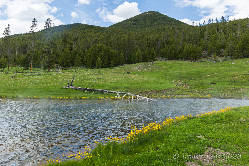
| Terrace Spring lined with yellow wildflowers |
There weren't a lot of vehicles in the parking area, which is one of the reasons we stopped here. Kim and I followed a series of boardwalks to a lovely blue pool lined with yellow wildflowers.
 |
| It's a wonder the flowers can withstand the hot water temps |
I was surprised to see wildflowers growing at waters edge. I guess those plants were hardy enough to withstand the spring's hot temperatures.
 |
| Pretty blue pool |
There were a few other hot springs to see. The surrounding grassland outside of the pools was a lush green, fueled by winter snowmelt. I don't think this area had been snow-free for long - spring comes late to the high country of Yellowstone (which is why they have to do all their road construction during the busy summer tourist season).
 |
| Another flower-lined hot spring |
Back in the car, on the road again! We pulled over to walk a nice path overlooking mighty Gibbon Falls. The path boasted some great clifftop views of the 84-foot-high cascade flowing through a rocky gorge.
 |
| Gibbon Falls |
Our next stop was at a geyser area called Artists Paintpots. Seeing the sign from the road, Kim and I decided to check it out. Although the parking lot was busy, I managed to find a spot for my car.
 |
| Artists Paintpots area |
We started off through a stark pine forest for about a half mile. The lodgepoles pines here were damaged in the great wildfire of 1988. Beyond this scorched forest, the terrain opened up into a barren, but colorful wasteland. An orangish creek flowed lazily through this plain, ferrying geyser discharge water.
 |
| Blood Geyser |
Stepping onto yet another boardwalk, the first geothermal feature I came upon was a geyser surrounded by red-stained soil. Appropriately named Blood Geyser, this little guy was bubbling mightily.
 |
| Steamy overview |
Beyond this first geyser, the boardwalk transitioned back into dirt trail that climbed a nearby hill. Kim and I huffed and puffed up the steep grade.
 |
| Interesting looking hot spring |
Our steep trek had its rewards. Once on top of the hill, Kim and I were treated to a grand view of the entire paintpot area, the surrounding forest, and a couple of snow-capped peaks way in the distance.
 |
| Another aerial view of Artists Paintpots |
From up here, the orange-ish, red-ish soil surrounding the geysers and hot springs really did look like a bunch of paint on an artist's palette. I later read that these bright colors were due to the abundance of iron oxide.
 |
| We climbed a steep hill for this view |
Another feature here on this hilltop was a large mudpot, full of boiling gray mud.
 |
| Bubbling mud pot |
As with the mud volcano area that we'd visited on our first day, this mudpot was mighty smelly! All thanks to the microorganisms that live in these hot, muddy areas using hydrogen sulfide to break down rocks into wet clay. The mud bulged and popped as gas bubbles rose to the surface.
 |
| Interesting colors and patterns on the mud pot's surface |
After watching the mud burble and spatter for a few minutes, Kim and I climbed down the hill and resumed our boardwalk tour of the final hot springs in this area. One in particular was an eerie gray-blue color. Guess that was the blue paint in the artist's palette!
 |
| Weird blue pool |
After the paintpot stop, I drove past the Norris Geyser Basin junction (we'd already visited all the geysers there yesterday) and then turned northward towards Mammoth Hot Springs. I'd driven about 10 miles up this road when we suddenly came upon a huge traffic jam. Cars were parked everywhere, lining both sides of the road. I knew what was going on. Seeing a place to park in a gravel pull out nearby, I guided the car into the spot and told Kim "there's an animal sighting nearby."
 |
| Mama Grizzly and cubs! |
Hurriedly I switched to my big zoom lens. Then Kim and I hustled towards where it seemed most of the onlookers were gathering. I asked a group who was walking back what was going on and they told me "A mama grizzly bear with three cubs is out beyond the trees."
 |
| The bears were adorable |
Good thing I had my zoom lens! The mama and babes were quite a distance and the extra magnification of my big lens helped me see them. Also considering it was a mother bear with young ones, I was glad they were far enough away that I felt safe watching. (And thankfully all the onlookers were being smart and keeping their distance.)
 |
| In this view all 3 cubs are visible |
The bear family were busy feeding, likely filling their bellies after a long winter. The cubs were so small the tall grass partially hid them at first. But eventually their mother wandered into a more open area and I was able to get some photos of all four bears.
 |
| The bears were busy feeding |
An amazing wildlife sighting! Kim and I lingered for at least a half hour. By then I had dozens of images and the bears weren't doing much but eating. Time to get travelin' to our final destination before it got too late in the afternoon.
 |
| Precarious roadway |
Approaching the Mammoth Hot Springs area, the road had to squeeze through a narrow canyon. In some places the highway was cantilevered over the dropoff, wedged beside a tall cliff face. We climbed steeply and then wound downhill, the road full of switchbacking curves. But finally we made it. Mammoth Hot Springs, get ready for Linda and Kim!
 |
| Minerva Terrace, Mammoth Hot Springs area |
Although yet another hydrothermal feature, the unique landscape at Mammoth Hot Springs sets it apart from the other geyser basins in Yellowstone NP. Instead of large pools of hot water or erupting geysers, the main formations here are large stepped terraces of colorful rock.
 |
| Looking back towards the hotel area |
A network of fractures and fissures in the underlying rock strata enable hot water to flow upward through the limestone layers. Scientists have not yet identified the volcanic heat source, but some believe it is due to a large magma chamber. The hot water from underground contains carbon dioxide and as this solution rises through the rock, it dissolves calcium carbonate, the primary mineral making up limestone. As the water bubbles out onto the surface, the calcium carbonate is deposited in the form of travertine, thus creating the unusual terraces one finds at Mammoth Hot Springs.
 |
| Palette Spring |
Due to the paintpot trek and bear viewing detour it was late afternoon by the time we rolled into Mammoth. And the temperatures were downright toasty! After missing the parking area and turning around in the small village of hotels and shops in the valley (and eyeing one store advertising ice cream) I found my way back to the lot providing access to the main terrace.
 |
| Cleopatra Terrace |
More boardwalks awaited us - and stairs! Since the terraces are stepped up hillsides, one must climb several feet of elevation to see them. Not what one wants to do when temps are in the upper 80s. But those colorful features of Mammoth beckoned, so Kim and I sucked it up and started out.
 |
| I spotted three elk! |
To reduce weight, I left my backpack with big zoom lens in the car. One our way up what should I spot on the hillside but three female elk. They were close enough, if I'd had my zoom lens I could've snapped some great images. But since I didn't, these were as good as I got with my 24-105mm lens.
 |
| Jupiter Terrace |
Despite the hot uphill trek, when Kim and I finally reached Jupiter Terrace, we gasped in awe. The terraces were a mixture of orange and white minerals. The travertine formed uniform steps that cascaded down the slope. It looked like a piece of art.
 |
| A closer look at Jupiter Terrace |
I read that it took hundreds of years of mineral deposits to form these intricate terraces. I also found out that the white or yellow colors indicated the hottest water, while orange, brown or green colors were created from (relatively) cooler water. Mother Nature is pretty darned amazing!
 |
| The terrace formations were incredible! |
Many photos were taken.....and I don't feel my images really did the place justice. All I can say is go see it for yourself if you get the chance.
 |
| Selfie time! |
I would've loved to explore the area further, but the heat and the long day had taken its toll on Kim and I. The ice cream in the general store was calling. So we turned around and retraced our steps back downhill to my car.
 |
| Mound Spring |
On our way back, we stopped to view lovely Cleopatra Terrace, whose mineral deposits looked like candle wax dripping down the hillside. Not sure why these hot springs waters didn't form terraces like the other features.
 |
| More terrace detail |
Once at the car, I made a beeline for the main village area and that general store with the enticing ice cream sign. Apparently lots of other people had the same idea as us, because the line for frozen treats was long! But after our sweltering trek through the terraces, Kim and I had our hearts set on ice cream, so we braved the line and were duly rewarded. Boy did it taste good!
 |
| Some of it looked like melted candle wax |
By this time, it was past 6 pm and we needed to get to our motel for the night in the town of West Yellowstone, Montana, 50 miles away. The shortest distance to get there was back through the park. Although that might not seem very far, due to the tourist traffic it would take us nearly two hours to make our way there.
 |
| Another elk sighting |
One thing I'd forgotten when planning this trip for early June. Memorial Day to Labor Day is prime tourist time at Yellowstone. I was amazed at the number of people and vehicles on the road - on a Monday! Driving back through the park, I was consistently slowed down by large RV's, or people taking their sweet time. And there weren't many places to pass. Passing by the place where the bears had been spotted, the beasts were obviously still there, as evidenced by heavy traffic and vehicles parked everywhere. One car in front of me came to a dead stop on the roadway as the occupants tried to see what was going on. After a few minutes of no movement I laid on the horn. I'd had it with all the dumb tourists! Then, coming upon the Madison Junction, traffic again slowed and then crept along for several miles. We finally came upon a lone female elk next to the roadway. Everyone had been stopping to photograph the animal, thus causing the massive jam. Luckily by the time we passed by, a park ranger had come upon the scene and began to direct traffic. He motioned everyone to keep moving. Thank goodness!
 |
| Ice cream reward after a hot trek |
Finally we arrived at our (very expensive) hotel in West Yellowstone. For what they charged for one night, I wasn't impressed. But as we learned, you pay dearly for the convenience of staying close to a national park. After battling stupid tourist traffic all afternoon I was more than ready to relax with a cold beer (or three!)
Tomorrow we would start for home. But I had one final stop planned in central Idaho. Join me for my next post to learn all about Craters of the Moon National Monument.