Tuesday, July 29, 2014

Silver Star Mountain

For the past four years, I've been trying to get back and hike Silver Star Mountain.  A 2010 hike on the famed Ed's Trail was so fantastic, it left me eager for a revisit.  But busy summers, a horrible entrance road, and other matters (such as getting lost trying to find the trailhead one year) kept me away.


Ready to hike!

Finally, two weeks ago, I hatched a plan.  Offering to take a vacation day, I convinced my friend John to rally his retired hiking friends for a mid-week ramble up Ed's Trail.  John didn't take much arm-twisting!  He gathered a group of five wonderful people and we picked a day that promised sunny weather.


Fog bank below the trail

Ed's Trail is one of the premiere summer wildflower hikes in Southwestern Washington.  Traveling along a treeless ridge, flowers bloom thick in mid-July.  And the views can't be beat!  In 1902 this entire area was charred in the Yacolt Burn, the largest wildfire in Washington state history (well, until this summer).  Trees failed to reseed here, which opened the landscape up for wildflowers to flourish.


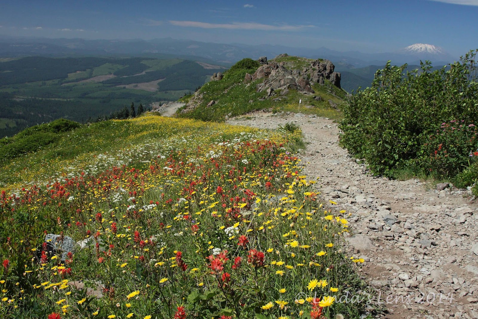
Mt. Rainer and Adams make appearances

However, admission to this wonderful trail requires a slow slog over a terrible gravel road.  I'd heard reports this road had deteriorated so much it was barely passable for cars.  Putting John's Subaru to the test, we soon discovered this was indeed true.  Lurching through gigantic potholes, my friends and I often wondered if the car was going to make it (we did scrape bottom a couple of times).  But, to everyone's relief, John's expert driving skills got us to the fog-shrouded trailhead in one piece.


Climbing through the yellow slopes

Although our trailhead was socked in, by the time we'd all unloaded, put on our boots, and taken last-minute potty breaks, blue sky was beginning to peek through the clouds.  Climbing the first quarter mile took us out of the fog for good.


Incredible St Helens view

And - oh the views!  They were fabulous from the get-go.  A lingering fog bank hung in the valleys, creating a surreal scene.  From the first vantage point, three snow-capped mountains - St. Helens, Rainer, and Adams poked their peaks above the clouds.  A kaleidoscope of wildflowers provided the perfect foreground.


My favorite image of the day

This shot of Mt. St. Helens rising above the foggy valley was hands-down my favorite image of the day.

The group contoured along the ridgeline, past fields yellow with a zillion flowers.  The "big three" mountains continued to anchor the horizon, creating perfect photo ops.  It was hard not to stop and photograph the changing scenes every five minutes.


Group photo op at rock arch

One of the cool things about Ed's Trail is it passes through a natural rock arch.  That's something you don't see every day.  Perfect place for a group photo!


John in mid-climb

Then comes the fun part - a small climb up a short, rocky slope.  It required using both hands and feet to traverse.  But it was worse than it looked, and I had an easy scramble.  Kind of fun to mix things up a little bit!


Three peak view - St. Helens, Rainer, Adams

And upon reaching the top, you're rewarded with views like this.  The forested hills drop away on all sides, revealing a three-peak panorama.


Silver Star summit

Reaching a trail junction with an abandoned road, our party climbed the final half mile to Silver Star Mountain's bare, rocky summit.


Summit views

Clear sunny skies, meant 360 degree views.  You could see all the Cascade Peaks - not only the "big three" we'd been seeing all morning, Mt. Hood made an appearance on the southern skyline.  And if you looked hard, one could spot the white pointy tip of Mt. Jefferson.


More summit views

My companions and I settled down on the concrete foundation of a long-ago lookout tower and enjoyed lunch with a view.


Wide open vistas below the summit

After a nice break, John rallied the group to continue.  He wanted to hike a mile south of Silver Star's summit to visit the ancient Indian pits.  So down the mountain's steep, flower-filled slope we plunged.


Butterfly poses for me

The flower fields were full of butterflies.  Try as I might, I wasn't able to catch one of these beautiful insects at rest.  Then, finally John spotted a lone butterfly clinging to a flower.  It held still just long enough for me to fire off a half dozen shots.  Luckily, one of them did turn out.


Heading to the Indian pits

Our trail roller-coastered down one ridge, and up another.  Mt. Hood began to dominate the skyline.


Onto a rocky ridge

Then our group came upon a rocky talus slope.  It jutted out to a point.  With the land falling away on three sides, we again were treated to more wonderful views of the surrounding hills and forests.


John has a meditative moment

A line of rocky pits, each about six feet deep, had been constructed along the top of this ridge.  It's thought that these stone walls and depressions were built to be used as vision quest sites where young Indian men fasted until they saw a guiding spirit.

John sat down in one of these pits, and had a contemplative moment.


Relaxing in the rocky pit (photo by John)

I, too, climbed inside and briefly rested my tired legs.  But those rocks didn't make the most comfortable of seats, so I didn't linger.  Those Indian men were a lot tougher than weenie old me!


Nice views on the return trip

Then it was time to retrace our steps, back across the rocky ridge, past more incredible views and flower gardens.


Wide open ridge

Again, I really loved the wide-open views here.  So glad to have visited on a clear day!


Climbing through the flowers

My party climbed back up the flower-spangled side of Silver Star Mountain.


Another butterfly supermodel

Where I made another winged friend.  This one posed for a long time!


Wildflower central

Then came the cherry on top.  For the final leg of our journey, John led us down another abandoned road that wound through a spectacular field chock-full of wildflowers.  This was by far the day's best floral display!


Flowers and MSH view - it doesn't get any better!

The surrounding meadows were a colored bright shade of yellow as far as the eye could see.  And popping up over the horizon was none other than Mt. St. Helens, the day's constant companion.  Oh my - views just don't get any better than this!


Flower-lined trail

I spent way too much time in the meadow with my camera, and before I knew it, my friends had abandoned me.  Since the trailhead was only a couple of miles away, they continued on, knowing I'd eventually catch up.

Wandering along the road, I must've snapped over a hundred photos.  Around every bend were more colorful flowers, and another new perspective of the mountain scenery.  Finally, having had too much of a good thing, I began to get picky, and would only stop for the truly outstanding scenery.


Time for beer!

Back at the trailhead, everyone agreed it had been one stellar day.  Yes, Ed's Trail is definitely a crown jewel of PNW hiking trails.  Totally worth burning a vacation day to visit!


Sharing with:  Our World Tuesday and Weekly Top Shot.

Thursday, July 24, 2014

Beargrass and Mosquitoes

It's time to explore the McKenzie Highway!

Day three of our July 4th camping trip, I talked my hubby into making the short drive from our campsite at Clear Lake to a trail off the McKenzie Highway.


The beargrass is blooming!

The McKenzie Highway (aka Oregon State Hwy 242) is a steep mountain road that winds its way up through the Cascades until it reaches McKenzie Pass, elevation 5,325 feet.  Snowstorms make plowing difficult, so the highway is closed every winter.  I'd never before traveled this road, and heard it offered great views and lots of good hiking trails.  We were so close, it was a perfect opportunity to check things out.


Bear wants some bacon

But first Roger made a hearty camp breakfast - hashbrowns, eggs and bacon!  The smell of frying bacon held Bear's attention.  We did share a small bit with our doggy.


Benson lake trail

Then we piled into Roger's truck and headed towards the day's destination - Scott Lake Trailhead.  Once on the McKenzie Highway, I immediately realized why this road is closed every winter.  It was winding....and narrow.....and really, really steep!  The lanes were barely wide enough for Roger's big pickup.  Some of the sharp curves were so tight, it forced us to slow down to almost 15 mph.  It was a slow go.  And Roger was none too happy about driving through such tight switchbacks.


Tons of beargrass was blooming
But the scenery was wonderful!  Dense dark green woods lined the roadway.  As we climbed higher, I began to see the forest floor was covered with white poofy beargrass.  And it was thick!

Finally, I spotted the turnoff for Scott Lake Trailhead.  We bumped down a gravel road for a short distance until I spotted the sign for Benson Lake Trail.


Lodgepole pine

We made it!  I hopped out of the truck to put on my hiking boots and was immediately swarmed by a cloud of mosquitoes.  Apparently we'd timed our arrival for peak mosquito season in the high country.

While I laced up my boots, Roger slapped and swatted the pesky critters.  Finally, he could take it no longer.  Grabbing Bear's leash, Roger said he needed to start moving.  He offered to  hike up the trail a ways, and meet me at Benson Lake.


Beargrass valley

Today's hike of choice was a short 1.5 mile trek to tiny Benson Lake.  I secretly hoped Roger and Bear would be content with hanging around the lake, and I could continue on to the summit of nearby Scott Mountain.  But not only were the biting bugs thick today, temps were also heating up.


Lovely reflections in a nearby pond

The trail began in a forest of gnarly old lodgepole pine.  White fluffy beargrass plumes lined my path, making tempting photo subjects.  Last year had been such a good year for beargrass, I didn't expect to see such large amounts of it blooming once again.


Beargrass reflections

As long as I kept moving, the mosquitoes left me alone.  But once I stopped to say, take a photo, it was as if I'd rung the dinner bell.  Luckily I was wearing pants and a long sleeve shirt, and this helped shield most of my exposed skin.  Although the day was hot, I chose to keep myself covered up.


Benson Lake

The trail climbed all the way to Benson Lake.  The high elevation forest wasn't as thick as the forests on the west slopes of the Cascades, and bright sunlight beat down upon me.  Sweat poured out of my body, and dripped down my face.  If it wasn't for the lovely beargrass show along the way, hiking this trail wouldn't have been much fun.


Gnarled old tree

About a quarter mile from the lake, I ran into Roger and Bear heading back.  Roger said the mosquitoes were too bad for him to sit around the lakeshore.  He'd decided to return to the trailhead, and would meet me at the truck.


Yet more beargrass

I finally arrived at Benson Lake.  It was a pretty blue mountain pond, rimmed by cliffs on one side.  A couple of nearby small ponds had great reflections of the adjacent trees and plants in their waters.  I wandered around with my camera, recording some of the sights.  But the biting pests buzzing around my head wouldn't allow me to linger for too long.


Beargrass macro shot

Since Roger was already grumpy from having to drive that narrow windy road, and endure the heat and biting mosquitoes, I didn't want to make him wait too long for me.  So my time at Benson Lake got cut short, and continuing on to Scott Mountain was out of the question.  Back down the trail I traveled, stopping to snap an occasional shot of beargrass.


A relaxing afternoon at camp

After a harrowing drive back down the McKenzie Highway, I treated my hubby to an ice cream bar at the Clear Lake resort store.  Ice cream always makes everything better!

Despite the heat and annoying bugs, I enjoyed my short trip up McKenzie pass, and hope to return again soon.  Although the next day we had to pack up camp and return to the "big city," it was nice to spend a quiet 4th of July weekend exploring a new part of Oregon.


Sharing with:  Weekend Reflections and Weekly Top Shot

Monday, July 21, 2014

Waterfalls of the McKenzie

I didn't mean to keep everyone hanging so long, waiting for part two.  But....sadly life (aka my real job) gets in the way of other fun stuff (such as taking photos and blogging about them).

But now without further adieu......I give you day two of our July 4th camping trip!


Clear Lake in the morning

If you read my last post then you know my hubby and I decided to spend July 4th weekend up in the Cascade mountains camping.  We chose a lovely spot at Clear Lake, and had a wonderful first day checking out it's shores.


Roger and Bear ready to hike

Day two, we were ready for more exploration.  A mile from our campground was the McKenzie River trail, which of course followed the McKenzie River, a whitewater mountain stream.  Along this trail were two impressive waterfalls - Sahalie and Koosah Falls.


Our trail for the day

Roger, Bear, and I began our hike following Clear Lake's grassy shoreline, offering occasional glimpses of it's lovely blue-green waters.  At a junction, our path left the lake, and plunged into an old-growth forest full of huge Douglas Firs.


The trees were ginormous! (photo by Roger)

It wasn't long before we heard the rushing waters of the McKenzie River.  The trail led us across the highway and began to parallel this lovely churning stream.  The water, originating from the springs above Clear Lake, was tinged with a hint of blue.


Lovely McKenzie River

Our hike today was a short 4.6-mile loop.  We'd first traverse the east side of McKenzie River, taking in the developed (aka "touristy") overlooks for both waterfalls.  Then, our trail would turn and cross the river, leading back across the western bank, for another view of both cascades.


Posing on the log bridge

Our loop began at a rustic log footbridge over the McKenzie.  We'd cross this on our return trip, but both Roger and I couldn't resist climbing up and checking out the river.  Plus, the bridge made for some great photo ops!


My boys on the bridge

Even Bear followed us up there!


This squirrel was hoping for a handout

As I was packing up my camera, Roger spotted a squirrel cautiously creeping across the bridge.  The little guy was obviously used to being fed by hikers, and I think he was hoping for a handout.  Mr. Squirrelly didn't get any grub from us - but he did get his picture taken multiple times.


Sahalie Falls

Not far from the footbridge, I began to hear the sound of water roaring.  Our trail became more developed, with log handrails to protect visitors from falling into the steep canyon below.  This path led us to a large overlook, and there before us was the raging torrent of Sahalie Falls.


One of the many river overlooks

At 100 feet in height this waterfall, swollen by snowmelt, resembled a thick firehose.  Spray swirled up from it's base, dampening my camera lens even though I was nearly a football field's length away.  Due to poor lighting and interference from other visitors, I was disappointed with my photo attempts.  But I'm including one image here, so you get to see it anyway.
 

Koosah Falls

On to the next waterfall!  Another half mile of following the lovely McKenzie brought us to Koosah Falls.  I liked this cascade much better.  Although shorter than Sahalie, (only 70 feet in height), it was thinner and more delicate than it's big sister.  And it had multiple water streams flowing down the cliff face.


Koosah Falls zoomed out (photo by Roger)

Later research explained the origin of the waterfall's unusual names.  "Sahalie" meant such things as "top," "sky," and "heaven" in Chinook jargon (which was the old trade language of Northwest Indians).  "Koosah" also meant "sky" or "heaven" in Chinook.


Ultra-blue waters of the McKenzie

After checking out the wonderful developed overlook for Koosah Falls, Roger and I continued along our riverside path.  We came out at a dam above a small reservoir.  Crossing the river on a road over the dam brought us to the western side, and the return trail.


Roger perched on the cliff's edge

The western trail was less developed, and much rougher.  I climbed over rocks and tree roots, watching my every step.  The riverbank began to get higher, and steeper, until it became a tall cliff.  It was there that we came upon Koosah Falls once again.


His shot of Koosah Falls (photo by Roger)

It was fun to see this waterfall from a different angle.  However, there were no handrails or developed overlooks here.  Roger perched precariously on the cliff's edge to snap a couple of images.  I edged as close as I dared, but not wanting to make the evening news, stayed a good distance away.


Tiger lily!

Then we continued on, up the path, climbing through the forest.  I spotted a few flowers still blooming - tiger lilies, and a couple of gorgeous white Cascade lilies.  We ran into quite a few groups of mountain bikers.  I was surprised to see so many people riding bikes on this rocky, narrow trail. 


Our trail went right through this downed tree

Especially when the trail crossed a downed tree via a makeshift staircase!  Wonder how the bikes rode over this?


Another view of Sahalie Falls (photo by Roger)

By now the sun had risen high in the sky, and things had begun to warm up considerably.  But passing by Sahalie Falls one last time, the spray from this churning monster cascade provided a nice cooling mist.  Refreshed by this unexpected shower, Roger and I headed for the footbridge, and our campsite.


Cascade Lily

By this time our poor old doggy was beginning to flag.  We didn't want to leave him alone at our campsite, so he had to come along.  Bear did pretty good up until the final mile, when his ailing back legs began to act up.  But old Bear was a trooper, and was able to make it all the way back to camp, where he curled up and slept the afternoon away.


Heading back to camp

A lovely hike indeed!  It was great to be able to access this trail right from our campsite.  It was such a beautiful path I was tempted to sneak out and do it again.

We spent July 4th eve peacefully sitting by the campfire (no fireworks allowed in the National Forest) with a tired doggy snoozing nearby.  But I was already planning the next day's hike - a trip up McKenzie Pass to explore a high alpine lake. 

Check back for my next post, and I'll tell you all about it.


Sharing with:  Saturday's Critters and Our World Tuesday.