Wednesday, December 30, 2020

2020 in Photos

Ugh.....2020 is a year we'd all soon like to forget.  It started out with so much promise - a new decade, a blank calendar full of possibilities.  I made so many plans; hikes, outings, trips, family reunions - only to have everything come crashing apart in mid-March.

I think back to January 2020 and remember how carefree and optimistic I was then.  I had no idea how much life was about to change.  From being kicked out of my office and working at home for 9 months, not seeing friends and family, to wearing a mask everywhere I went, using more hand sanitizer in 6 months than I ever have in my life, and being super paranoid of getting too close to anyone.  But at least outdoor activities were not off-limits, and hiking was one of the things that kept me sane throughout these difficult months.

I've been creating my "Year in Review" post now for the past 9 years.  It started with one photo from the blog for each month.  As the years passed and my blog got terribly behind current times, I instead started choosing favorite photos for these year-end recaps, or like in 2019, favorite hikes from the past 12 months.  

But this year I'm going back to the original theme - 2020's "Year in Review" will again feature photographs from the actual month that they occurred.  And instead of choosing favorite photos, some of these images will depict important, memorable, or timely events from this most unusual of years.


January


2020 started out with a bang, or at least a splash, with a field trip to watch huge waves crashing ashore at Washington's Cape Disappointment.  My neighbor Cheri invited me to join her to capture this unusual convergence of high tides and ocean wave activity.  We spent a memorable first day filling our camera's memory cards with amazing images.  Such a fun way to start a new decade, at the time I foolishly believed it was a precursor of great things for the coming year.


February


Over President's Day weekend, I convinced my hubby to join me on a snowshoeing outing.  We chose the June Lake Trail near Mt St Helens.  Having snowshoed this same trail exactly one year ago, I was surprised by how low the snow levels were when compared with the previous year's trip.  But there was a fresh dusting of the white stuff and when it sparkled in the sun the forest looked positively magical.


March


One week before life came to an abrupt standstill I decided to hike the Multnomah-Wahkeena trail in the Gorge.  It was an awful rainy, cold, borderline-snow day and I almost turned the car around and headed back home.  But needing a break from the impending pandemic hysteria, I donned my raingear and persevered.  As I climbed higher raindrops transitioned into snowflakes until the entire forest was transformed with a white coating.  I had the best time walking through this unexpected winter wonderland - it became one of my best hikes of 2020.


April


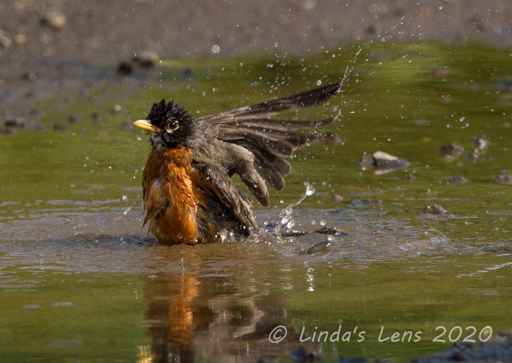
From mid-March through April everything shut down and I was confined close to home.  No hiking trails were open and the ski areas shuttered.  What to do?  Hone my bird photography skills!  I filled my now-abundant free time with pilgrimages to the local wetlands and nearby parks to capture the spring birds and baby ducks.  This month features two photos because I just couldn't choose between the splashy robin bathing in a puddle and the cute, fluffy gosling who posed so nicely for my camera.


May


In May, hiking trails began slowly opening up.  May 18th was also the 40th anniversary of the Mt. St. Helens eruption.  Since one of the places with open trails happened to be on the mountain's north side, I made a Memorial Day visit to pay my respects and hike a "new to me" section of the Boundary trail from the Hummocks up to Johnston Ridge.  Note that the photo also shows an addition to my hiking attire - a face covering, which became standard equipment for trekking any trail in 2020.


June


Despite COVID cases increasing, most of the local trails reopened by June.  To make up for lost time, I ramped up my hiking trips this month, averaging two a week.  Since I missed out on the April-May Gorge wildflower show, I hiked several places with blooming rhododendrons to get my spring flower fix.


July


In July the Comet Neowise made a special appearance in the night skies over Oregon.  Thanks to my neighbor Cheri I met up with a group of women photographers on a remote road in the far eastern Gorge for a once-in-a-lifetime chance to photograph this unusual comet. (It only comes around every 6,800 years!)  Having never attempted night photography not only was it a huge learning curve, but seeing and capturing the comet with my own eyes (and camera!) was one of the coolest photographic experiences I've ever had.


August


During an August camping trip in Southern Oregon with my hubby and brother we decided to visit nearby Crater Lake.  None of us had ever hiked the short path from the rim to water's edge, so one warm morning we traipsed down the steep Cleetwood Cove trail to check things out.  I was surprised to see so many people swimming in the lake's pure blue waters (and also to learn swimming and fishing were allowed!)  Although only a short jaunt, it was one of the most fascinating destinations I hiked to in 2020.


September


September was a month of heartbreak, as 2020 reared it's ugly head once again.  A Labor Day windstorm downed powerlines and sparked several huge wildfires in parched forests across the state of Oregon.  Five small towns burned to the ground, and scores of favorite hiking trails and unique forest environments were torched.  For 10 long days acrid smoke filled the skies overhead causing air quality to spike off the charts.  With absolutely no place to go (air quality was considered "hazardous to health") my hubby and I hunkered indoors staring at angry orange skies and sadly watching online fire perimeter maps gobble up more and more forest land.


October


Ah October!  My most favorite hiking month!  Skies cleared and leaves began their seasonal color changes.  And this year I finally made it to Mt Rainer National Park to witness the spectacular autumn colors at Paradise.  I used to think the summer wildflower season was the best time to visit Rainier but after this trip autumn may have won me over.


November


Although high mountain autumn colors peak in October, in the Gorge and Portland area they don't reach full force until November.  Fall color was weird this year, as some places the leaves turned early, others turned late, and some leaves simply wilted and fell off the trees without any color (I blamed the September wildfire smoke).  But one of my favorite November hikes, Hamilton Mountain always provides a spectacular autumn leaf show.


December


I really haven't blogged yet about skiing in the time of COVID - but in December Oregon's ski resorts opened their doors once again.  I made four trips to two different ski resorts and had some interesting experiences.  A future blog post on this subject is forthcoming, but in the meantime I think this photo of me at Mt Hood Meadows with my face fully covered kind of summarizes resort skiing for the 20-21 season.  No need for sunscreen anymore!

------------------------------------------------------------------------------------------------------------------------


And now for my biggest, best news of 2020 - on December 31st I'm retiring from the job I've held for almost 32 years!  Yeah!  Midweek skiing and hiking here I come!  I'm so looking forward to more free time to pursue my photography to it's fullest and hone my photo editing skills.  I'm planning to revamp this blog (so many things are horribly outdated...) and set up a website so I can sell prints of my images.  And hopefully travel again, if this pandemic is ever put to rest.

As always, thank you to my readers for the comments, likes, and for continuing to read my ramblings.  I know retirement will bring new and interesting adventures - so please keep visiting and come along with me on this exciting next phase of life.

Good riddance to 2020!  I'm hopeful for better times in 2021.  Wishing you all peace and health in the coming new year.


Friday, December 25, 2020

Rain Escape on the Deschutes

After an extremely rainy mid-November week I was seeking sunshine and dry trails for the weekend.  As many Portlanders know, if you want to escape the rain -  head east! 


Waterfowl

 
If one travels a mere 90 miles due east of the Willamette River Valley, you enter a totally different world.  In the rainshadow of the Cascade Mountains, when Portland is soggy, the area east of The Dalles is reliably dry and sunny.


Churning waters

 
The Deschutes River, traveling from Central Oregon meets the Columbia River in a barren, but scenic desert canyon.  A state park located at the mouth of the mighty Deschutes offers a campground and many hiking trails following the river.


Red leaves add a pop of color


It was a leap of faith for me to travel through an early morning rainstorm, hydroplaning on Interstate 84 through the Columbia River Gorge, to reach this reputably dry area.  Many times I thought to myself "What am I doing?  What if it's just as rainy in the Deschutes Canyon?"  But, just past Hood River, the rain began to let up, and by the time I'd passed The Dalles, a tiny bit of blue sky was poking through the clouds.  Pulling into the Deschutes River State Park, chilly but dry weather greeted me.  Hooray!


Interesting black branches

 
It had been many, many years since I'd hiked here and I'd totally forgotten where to find the trailhead.  But even more pressing - finding an open restroom!  Thanks to COVID, most of the "facilities" in the park were closed.  I was almost ready to hide behind some bushes when I discovered the bathrooms closest to the trailhead were still open.  Whew!


Seed pods


Three separate trails began at the campground.  One, an old gravel road high above the river catered more to mountain bikers.  Two other hiker trails followed the river, one at bank level, while the other meandered through terrain between river and road.  And a bonus fourth path, known as the Ferry Springs Trail, climbed high bluffs above the gravel road for spectacular views of the surrounding area.


Looking down the canyon


The trailhead itself wasn't easy to find.  After wandering aimlessly for several minutes I discovered it by following another party through a large field.  Here a state parks sign (looking very much out of place next to a field) pointed to the beginning of both lower trails.  Which to chose?  Hoping for more views, I opted to try the riverbank trail first.


Bright orange bushes

 
I chose well.  The riverside trail didn't disappoint, meandering along at water level.  Right off the bat I spotted a huge flock of Canadian geese and some Bufflehead ducks floating in the river.  Although the main fall colors had faded, a few straggler bushes provided a bit of contrast to the otherwise brown canyon walls.


River rafter

 
I spotted two men in pontoon-like rafts floating downriver.  From the amount of gear strapped to their rafts it appeared they had been on a camping trip.  What a fun adventure!  I would've loved to chat with the guys about their experiences, but since they were in the middle of the river and I was on shore, all I could do was give a friendly wave before they were quickly swept away.


Rafting pair


Despite it's lack of color, I thought the Deschutes River canyon was mighty scenic, in a sweeping, wide-open kind of way.  Gentle hills, creased from years of erosion, rose from both river banks.  Looking downriver, the canyon walls steepened dramatically, framing the water.


Rocky stretch of the trail


In July 2018 a huge wildfire here charred both sides of the Deschutes, burning grassland and trees for 25 miles of the lower river.  All 8500 acres of the state-managed recreation were affected.  Only the state park campground at the confluence of the Deschutes and Columbia Rivers was miraculously spared.


More fab views

 
Although only two years had passed since the terrible blaze, I saw very few signs of the devastation along the river.  Nature is good at rebounding from natural disasters.


Fluffy seed pods


I did see many different type of seed pods in the grasses and vegetation lining the river banks.  Always good photo subjects!


The trail cut through tall grasses
 
 
Despite the long drive and relative isolation of the area I was surprised to see many groups hiking the trail.  Due to the drier climate, this area is a popular place to backpack in the winter and spring seasons. I ran into a large group of backpackers who had started at Macks Canyon, 23 miles upriver.  One of the ladies, who looked extremely weary asked hopefully "are we close to the state park?"


Puddle on the road


After 3.5 scenic river miles I came upon a wide path leading hikers uphill to the gravel road.  My crude map, a page from Sullivan's hiking book, seemed to indicate the river trail ended at nearby Gordon Canyon so I had no choice but to climb this trail to it's junction with the road.


Deschutes River below

 
Although I debated following the road further south, in the end I decided I'd traveled far enough for the day.  Instead of retracing my steps along the river trail, I opted to explore the gravel road for my return trip.


Road walk views

 
Oh what fabulous views awaited!  The road, perched high above the canyon, offered birds-eye panoramas of the river and canyon.  Following a long-abandoned railroad grade, it was delightfully flat and I was able to walk easily while taking in the surrounding scenery.


River rapids


Sometime in the 90's my family had camped at the Deschutes State park and my son and I had hiked a portion of this road.  Although I didn't remember much from that hike, I did recall that we'd spotted two rattlesnakes that day, the only ones I've ever seen in Oregon.


Sweeping views to the south


However, on this chilly fall day there were thankfully no snakes to be found, only wonderful river views and blue skies.


Looking down from the Ferry Springs trail


I came upon a side trail leading to a rocky outcrop overlooking the river.  A couple ahead of me had climbed up there, and so when they left, I scrambled up to check things out.  As I was admiring the views,  I noticed a faint track winding uphill on the bluff across the road.  The only sign was a tiny "no bikes" placard.  Was this the Ferry Springs Trail?


Descent back to the road


My original plan was to intercept the Ferry Springs Trail - I incorrectly through it crossed paths with the riverside trail.  But having hiked a good portion of the riverside and not finding it I'd resigned myself to saving this trail for another trip.  But now......was this the trail I sought?  My crude map seemed to indicate it was.  Deciding I couldn't really get lost in this wide-open canyon country, I crossed the road and headed uphill to check things out.


Train heading into the sun

 
As I climbed the grassy bluff the surrounding canyon opened up to tremendous views.  I watched a freight train rumble through the canyon's opposite side.  Stretched along the canyon wall, sunlight glinted off the rail cars and I couldn't resist capturing the scene.  It turned out to be one of my favorite images of the day.


Lunch spot


The Ferry Springs trail (which I now assumed I was following) climbed to the top of the bluffs, then contoured around a tiny creek (the origin of Ferry Springs?) before diving back downhill to meet the gravel road.  Up here on the wind-swept prairie I noticed the only signs of the 2018 wildfire I'd seen thus far - charred fence posts and melted interpretive signs.


Upper trail


Intersecting once again with the gravel road I noticed another trail heading downhill towards the river.  Was this the middle trail?  Again, no signage existed so I had to guess.  It looked more interesting than the road, so I opted to follow it instead.  Not far down this path I came across a bench situated atop a flat area with commanding river views.  Having yet to take a lunch break, this enticing perch provided the perfect excuse to pause and refuel.


Colorful bushes line the river
 
 
Then, refreshed, I followed this middle trail as it wound downhill towards the river, back to the trailhead in a grassy field.


More great views as the river gets closer

 
Along the way I was treated to some lovely displays of fall color in the surviving trees and bushes lining the river's bank.


Back at the state park campground

 
Upon completion of my hike I lingered in the state park's campground and picnic area.  The weather had been so nice, I was reluctant to return to the wetter side of the mountains.
 

Picnic area
 
 
On the drive back home I took a detour up Rowena Crest to capture a few images of the Columbia River.  Although fall colors had now faded, the views were fantastic as always.


View from Rowena Crest


Although I'd escaped the rain all day, I paid dearly with another white-knuckle drive through a torrential downpour in the Gorge.  It got so bad I tucked behind another vehicle and slowed down considerably, while cranking my windshield wipers to their highest possible level.  I started thinking "Was this all really worth it?"


Iconic highway loop with fall colors

Of course the answer is yes.  Despite any difficulties, making the effort to escape outdoors and hike is always worth it!


To all my readers and followers - Merry Christmas!


Wednesday, December 16, 2020

Early Snow

In most years, snow is slow to carpet nearby Mt Hood and it's surrounding foothills.  We're lucky if the ski resorts open by Thanksgiving - and if they do, it's with a measly 2 foot base (get out your "rock skis!")  But, 2020 continues to be unlike any year, and in Mt Hood's case, this has actually been a good thing.  In early November, storm after storm brought inches of the white stuff to Oregon's Cascade mountains.  By mid-November nearly three feet of snow was covering the lower reaches of Hood.

Time for an early-season Trillium Lake snowshoe hike to check things out.  So the Friday before Thanksgiving I decided to break in my car's new snow tires and head to the mountain.


Trillium Lake's fantastic Mt Hood view


Although the Mirror Lake Trailhead was packed with vehicles, just down the road Trillium Lake's sno-park had only three it's lot.  As I was changing boots and trying to decide if I needed my snowshoes, another car pulled in.  The woman driving rolled down her window and asked if this was the trail "to the lake." She also gave herself away as a tourist when she asked where Mt Hood was.  Pointing to the parking lot's prominent summit view I commented "You aren't from around here are you?"


Ice just beginning to form


As suspected, the woman admitted she was visiting from New York.  I told her Trillium Lake was only a mile and a half down the closed road, and it appeared the snow was packed enough that snowshoes weren't necessary.  She thanked me for the info, and with that I shouldered my backpack and camera bag and headed down the road.  I hadn't traveled far when a grove of frosty bushes provided my first photo stop.  I was delayed long enough that the New York lady caught up.  We started talking and ended up hiking together all the way to the lake.


Selfie time!

 
Since most of my hikes this year have been solo, it was nice to have company.  I chatted with the woman (6 feet apart of course!) and provided suggestions of other places to see during her stay.  The woman asked me to snap a few phone pics of her against the scenery.  Finally reaching the lake, with it's stellar Mt Hood view, my companion gasped in awe and handed me her phone again for a few Instagram-worthy shots.


More mountain views


With that, I parted ways with my new friend.  Having more places to visit, she retracted her steps back to the parking area, while I lingered around the lakeshore.  The weather was perfect - clear, blue skies and moderate temperatures.  Slogging through churned-up snow along the bank, I came to a sunny spot near the dam with killer Hood views.  Good place for a snack break!


Much too friendly gray jay eyeing my snacks


Sitting in the snow, munching on an energy bar and drinking tea, it didn't take long for the local gray jay population to take notice.  Several birds perched on nearby branches, eyeing my snacks.  I wasn't in the sharing mood so the birds were out of luck.  I did however manage to snap a few images of these cute feathered friends.


Sunburst


By this time it was late morning, and the recreational crowds began arriving.  A few groups of cross country skiers shuffled by, followed by another snowshoer.  I plowed through the snow on foot - it was surprisingly deep - to another vantage point across the earthen dam.  The sun's rays created lovely bursts of light and I managed to capture a couple photos I liked.


Frozen leaf


But the arrival of more folks made me decide it was time to leave.  Following the road back to the sno-park I began to encounter large groups of people until, over the last half mile, it became a continuous stream.  Despite the early wake-up time, getting to the lake early that day had had been a good decision.

The weather-guessers are predicting winter '20-'21 will be a La Nina year, which means wetter weather and more snow for the mountains.  This skier approves!  From the amount of snow I saw that day it appeared Mt Hood was off to a banner start.  But I'll keep doing my snow dances just in case (wink-wink!)


Sunday, December 6, 2020

Hamilton Mtn, Once Again

I've established a yearly tradition.  On November 11th (which is Veteran's Day here in the US) I always hike the Hamilton Mountain Trail.  Located on the Washington side of the Columbia River Gorge, I normally avoid this wildly popular trail during summer months.  However, by mid-November things usually quiet down enough for me to venture a visit.


Morning Gorge view at Cape Horn
 
 
I invited my friend Catherine to join me for the yearly romp.  Due to COVID precautions we decided to drive separate vehicles and agreed upon a trailhead meetup at the ungodly early hour of 8 am.  But one of the unexpected advantages of this predawn start - catching sunrise in the Gorge while driving Hwy 14 over Cape Horn.


Sunrise colors reflected in the river


Rendezvousing in the parking lot, Catherine and I chattered away, catching up on each other's lives.  With only a few vehicles parked at this early hour, I noticed a young man carrying a full size American flag head off towards the trail.  Possibly a veteran himself?


Colorful leaves


Boots on, backpacks loaded, it was time to tackle the trail!  Catherine and I headed out through a dense forest bursting with wonderful fall color.


View ahead to Hamilton Mtn summit


Not far from the trailhead, we passed through a clearing for large powerlines, providing great views of the day's destination - Hamilton Mountain's summit.


Beautiful forest colors


Then it was back into the lovely autumn forest for another half mile before reaching Rodney Falls and it's impressive top cascade, often referred to the "Pool of Winds."


Looking down from the top of Rodney Falls


The top of this waterfall drops through a narrow chasm in the cliff face.  The force of falling water combined with the rocky bowl's confinement often produces fairly strong winds, and water swirls forcefully through this gap before gushing further downhill.


Rushing creek through the trees


As per usual, Catherine and I hiked to the top of Rodney Falls and peeped through the rock slot, trying to avoid being pelted with water droplets flying out the the chasm.


Rodney Falls

 The autumn-hued forest views from the top of the falls were lovely.  


Colorful creek scene below the falls


Retracing our steps back to the main trail, we made our way across the sturdy log bridge under the lower falls.  Hardy Creek below the bridge looked fabulous, decked out in autumn golds.


Lone leaf


A few wayward leaves stuck to the bridge railing making for fine photo ops.


Sunburst through the forest


As we climbed out of Hardy Creek's canyon, Catherine noticed sunlight breaking through the trees.  It made some pretty sunbursts, which I couldn't resist trying to capture.


Columbia River and Beacon Rock


Beyond the creek crossing our climbing began in earnest.  Up, up, up the many steep switchbacks, our progress was measured by the shrinking Columbia River below.


First big viewpoint


Although we had many glances of our progress though gaps in the forest, our first big viewpoint came about a third of a mile later.  A rocky promontory jutted out above the Gorge affording a fantastic perspective of the Columbia River in both directions and the Oregon side of the Gorge.  Perfect place for some "Instagram-worthy" photo ops too!


Foggy cliffs


Although we'd been lucky with sunny skies conditions changed as we climbed higher.  About halfway up was another fantastic viewpoint featuring high cliffs.  Today the entire area was caught in a fog bank.  It did make for some cool photos - a silver lining since we couldn't see much else.


Walking through the woods below the summit


About a half mile from the summit, Catherine and I ran into the flag-carrying young man from the parking lot, heading back down.  We commended him on his speed and dedication to holding a full-size flag the entire way and found out that, yes indeed he was a veteran.


Uber-mossy trees

Catherine and I also met a couple of women (one with a young boy) heading back down, who had climbed to the summit for sunrise.  Neither of them realized that this hike had a loop option, which I gladly explained to them for next time.


Leaves still hanging the trees


Hamilton Mountain's summit is kind of a disappointment.  It's bushy, tree covered, and doesn't provide many views.  But the vegetation did provide shelter from the winds, and made a nice place to take a break.  But as Catherine and I were sitting down to an early lunch, the clouds decided to pelt us with tiny ice pellets.  What a dirty trick!


Impressive Gorge view from the saddle


In my opinion, the best part of the Hamilton Mountain trail is the loop hike past a wide-open saddle area.  I commented to Catherine that the women we'd talked to on the trail were really missing out just hiking an out-and-back trek from the summit.  


Looking back at the saddle


After finishing our lunch, my friend and I headed off the summit, passing through forest and tunnels of mossy vegetation for 3/4 miles until coming out on the most impressive viewpoint of them all - a treeless saddle providing sweeping panoramas of the Columbia River, Gorge, and adjacent Table Mountain.  On clear days, the tips of Mt Hood and Adams are also visible.  Although we didn't see the mountains that day, swirling clouds and fog made for some great dramatic images.


Sign selfie


 Also, this lone sign at the trail junction makes a great selfie spot!


Trail junction


Then it was back downhill through more mossy woods, to an overgrown road, past a lone outhouse (so much appreciated!) until another trail junction near upper Hardy Creek.


Leaf-littered bridge


Catherine and I dived back into the woods, through mostly barren trees and leaf-littered bridges.


Barren forest


In previous years this portion of the trek has been full of gorgeous fall color, but unfortunately this year I hit it too late.  But even without leafy trees, I still found lots of good stuff to photograph.


Leaf collage on the forest floor


Can't go wrong with a leaf collage on the forest floor - Mother Nature's artwork.


A few stray leaves still stuck to trees


Or a bunch of colorful leaves pasted on a mossy tree trunk.


Yellow forest


Finally, completing the loop, we arrived at our last junction - back at the original Hamilton Mountain Trail.  From here it was a matter of retracing our steps the final mile and half to the parking area.


Lots of color


Although still cloudy, the light was much brighter than when we'd passed through in the morning, so I couldn't resist taking a few more images of the forest color as we marched back.


Golden leaf tunnel


Another great fall hike in the books!  A wonderful day to wander along a classic Gorge trail and catch up with my friend.