Friday, November 19, 2021

New Boots Maiden "Voyage"

After my old hiking boots caused uncomfortable foot pain during a mid-September hike to Crystal Lakes, I knew it was time to spring for a new pair.  Since I've worn the same brand of hiking boots for many years (Lowa Lady Light GTX if you're curious), picking out a new pair is easy - all I do is go to REI's website, give them my credit card number, and hit "purchase."

These aren't the cheapest hiking boots by far but they've always worked well for my post-bunion-surgery, extremely fussy feet.  Lots of hikers these days are foregoing boots in favor of lightweight trail running shoes, but I've always preferred the stability and protection boots offer.  I feel the extra weight is worth it.


Shiny new boots - not for long!

After my new boots arrived in the mail, it was time to take them for a test drive.  I decided upon a short hike on the Mirror Lake Trail and maybe continuing to Tom, Dick and Harry Mountain.  Although the original plan was to get up early to avoid driving in rush hour traffic, my lazy retired self ended up sleeping in.  By the time I woke up there was no way I'd avoid rush hour.  So I dilly-dallied around the house until nearly 10 am before deciding to set out.  Surely traffic would have tapered off by now.


Vine maple just getting started around Mirror Lake

Well the answer to that - a resounding NO.  From where I live, reaching Mt Hood requires a drive through the heart of downtown Portland.  Usually by mid-morning freeway traffic has dropped back down to acceptable levels and it's a relatively quick trip.  But today, immediately after crossing the Willamette River, I discovered the exit to reach the main eastbound freeway closed.  Traffic was diverted north, and my car joined the throng of creeping vehicles searching for a detour.  After sitting in traffic for a frustratingly long time (and nearly bagging the whole hike and heading for home) I was finally able to exit the freeway.  Zig-zagging through the heart of the city, I found a spot to rejoin an opened portion of the eastbound freeway and continue my journey.  All of this rerouting took a good hour - which meant it was nearly 1 pm when I arrived at the trailhead.


The seasonal transition has begun

Once parked I beelined for the restroom (after sitting in traffic for nearly 3 hours I had to GO!).  I then slipped on my new hiking boots and snapped a photo for posterity.  (They'd never be this clean ever again.)  Happy to finally move my feet, down the trail I went.


A few spots of color on adjacent hills


Due to it's proximity to the main highway and fairly short distance (2 miles) the trail to Mirror Lake is wildly popular.  But on this day I met more people heading back down than going up.  Although a bit of climbing is required to reach the lake, I powered up the switchbacks like they were flat land.  (All that sitting in the car made me restless I guess.)  Reaching Mirror Lake, I opted to take the clockwise trail around it's perimeter.


Windy conditions meant no reflections on Mirror Lake


Although it was mid-September, fall colors were just getting started here.  The vine maple was beginning to turn, their treetops a faint orange-yellow mixed with lots of green.  It was pretty and certainly worthy of a few photo stops.


Panoramic views at this clearing


Halfway around the lake, I detoured onto a side trail that I knew would give me a good vantage of Mt Hood.  Sadly a strong breeze kept Mirror Lake from living up to it's name.  No mountain reflections today.  But I did run into a very nice family enjoying the sunny day and the man was nice enough to snap a photo of me in front of the lake and mountain.


Lots of brilliant vine maple on this talus slope


Time to climb higher!  Leaving the lake area my trail continued it's climb to the summit of Tom, Dick and Harry Mountain.  (I have no idea how this mountain got such an unusual name....) 

(Edit - so curiosity got the best of me and I looked it up on Wikipedia.  Apparently the ridge was originally called "Tom Dick" mountain.  Then the Board on Geographic Names decided to be cute and added "Harry" in 1969.  Now you know!)


Colorful vine maple leaves


I'd forgotten how nice this trail really was.  I passed by a large talus slope with tremendous views eastward.  Fiery vine maple bushes lit up the rocky fringes, at this higher elevation the leaves in a more advanced stage of autumn coloration.


Huckleberry leaves 


I climbed higher, leaving the vine maple and reaching the huckleberry zone.  Here the huckleberry leaves had turned a brilliant crimson - just as beautiful as the vine maple.  Brown stalks of spent beargrass rose above the bushes.  I passed a huge rockpile at an important trail junction and began the final half mile climb to Tom, Dick and Harry Mountain's summit.  As I passed the rockpile, I met a lone hiker heading the opposite direction who happily proclaimed I'd have the summit to myself with all the Cascade peaks visible on this clear-sky day.


Lots of beargrass stalks near the summit


This was just the motivation I needed to navigate the final rock-strewn trail towards the summit proper.  Tom, Dick and Harry Mountain's summit is a mess of large slabby rocks, which isn't a lot of fun to walk through.  But upon reaching the top I gaped in awe at the amazing view I had of Mt Hood and Mirror Lake.


Perfect Mt Hood view from Tom, Dick and Harry Mtn


Clear blue skies flaunted a line of white-topped Cascade peaks across the northern horizon.  Besides the obvious Mt Hood front and center, I could see Mt Adams, Rainier, and St Helens.  Turning 180 degrees and facing south gave nice views of Mt Jefferson.  After taking all the requisite photos I settled onto a flat spot in the boulder field for a quick snack break.


Color on adjacent ski slopes


The mountain's rocky spine continued eastward along a high ridge and then curved to the south, forming a cirque with steep cliffs.  In winter months, this area is part of Mt Hood Skibowl's advanced terrain, catering to the more adventurous skiers.  Today the talus slopes featured spots of brilliant fall color.


Mt Hood view from talus slope


I spent the better part of a half hour basking in the late afternoon sunshine enjoying the marvelous views.  Last time I'd hiked up here the entire summit had been fogged in (see post here) and there was nothing to see.  And, like the lone hiker had predicted, I had it all to myself for the entire time.

It was difficult to pull myself away.  But I needed to get home at a decent hour, so back down the trail I finally went.


More vine maple


On my return trip I made a second stop at the talus slope to capture just a few more images of the stunning vine maple.


On the way back, Mirror Lake lived up to it's name


Approaching the Mirror Lake area once again, I initially thought about bypassing the lake and continuing my descent.  But then I decided, "It will only take a minute to to have a look - why not?"  Boy was I glad I did!

THIS is what I saw - to my delight the wind had died down leaving the lake as smooth as glass.  Not only that, the late afternoon sun illuminated it's waters a brilliant blue hue that perfectly showcased the lake's picture-perfect Mt. Hood reflection.


Ripples in the lake


The photos I took here ended up being my favorite from the entire day.  If I thought it was hard to tear myself away from the clear-sky views on top of Tom, Dick and Harry Mountain, it was doubly difficult to leave this gorgeous scene at Mirror Lake.


A few people still enjoying the water


But leave I finally did, back downhill for the final 2-mile trek to my car.  It was past 5 pm when I returned to a nearly empty parking lot, most of the other hikers having already departed.  The advantage to leaving the mountain so late?  By the time I reached Portland, evening rush hour was over and I flew through downtown without delay.  Maybe I need to hike in the afternoon more often!

Oh, and my new boots?  They performed fabulously and were properly christened with enough trail dirt to look well-used already.  

Thursday, November 11, 2021

Sunrise to Sunset

The Pacific NW is getting a visit from the dreaded "Pineapple Express."  It's been raining nonstop since morning, which means no outdoor activities for me today.  Perfect excuse to stay home and get caught up on blog posts!


Pre-dawn in the Gorge

In mid-September over the course of a week's time, the Portland area experienced a series of fantastic sunrises and sunsets.  Of course, I missed them all - and kicked myself every time the sky lit up at home and a local photographer posted their fabulous photos of the event on Facebook.  Since I live in a low-lying, heavily treed area, getting good or even mildly interesting sky photos from my front door isn't gonna happen.


Colorful fog

I wasn't the only one experiencing a bad case of sunrise/sunset FOMO.  My neighbor and photography-mentor Cheri was also lamenting missing all the recent colorful sky shows.  So we devised a plan.  Checking weather forecasts, it appeared the following Monday looked promising.  Cheri and I decided to make an early visit to the Portland Women's Forum Scenic Viewpoint in the Gorge, one of our favorite sunrise spots.


The fog begins taking over Crown Point

On the designated morning, I awoke early and joined Cheri as we sped through the metro area towards our chosen Gorge viewpoint.  However, just a few miles from our destination, we hit a thick fog bank.  Nooooo!!!


Pink-hued clouds at the Vista House

Since we were now almost to the viewpoint, there was nothing else to do but continue.  I totally expected another foggy fail, but upon arrival we were both pleasantly surprised to discover the Women's Forum Viewpoint perched above the fog.  And even better, the clouds made for some great sky drama.  As the sun rose, it lit up the fog in lovely purple hues.  A very popular spot for photographers, Cheri and I were the only ones there that morning (we assumed everyone else had been scared off by the fog.)  Although we didn't get a big colorful sky show, the fog and cloud drama was nearly as good.


Dramatic cloudy skies over the Columbia River

But as the sun climbed higher, so did the fog, eventually obscuring our view of the Gorge.  Time to move on!  Cheri drove to nearby Crown Point, the place we'd just photographed from afar, for an up-close view of the famous Vista House.  Originally built as a comfort station for visitors driving the Historic Columbia River Highway, this unique structure is always photo-worthy.  Sadly, due to COVID, the place was closed and vehicle parking adjacent to the building barricaded.


Clearer river views

But visitors could still access it's fabulous viewpoints on foot, and that's exactly what we did.  By now the fog was starting to lift, giving us something to see.  Low-hanging clouds made for some great images of the Columbia River looking eastward.  


Latourell Falls

Cheri and I finished up our morning with visits to a couple of our favorite Gorge waterfalls.  Due to the unseasonably dry summer Latourell Falls was merely a skinny stream.  (I'm sure with all the rain we've gotten it's raging today!)


Multnomah Falls

Multnomah Falls looked a bit better.  Of course this being Oregon's most famous waterfall, one always has to fight the tourists to get photos.  But Cheri and I managed to squeeze ourselves into a good spot.


Haystack Rock at Cannon Beach

Driving home from the Gorge late morning, Cheri asked if I was interested in catching sunset on the coast that same evening.  Well, she didn't have to ask twice - of course I said yes!


Setting sun on the ocean

I had about two hours at home to grab a bite to eat, recharge the camera batteries, and pack a warm jacket.  Then Cheri pulled into my driveway and we were off once again.  Luckily, the Oregon coast is only a one-hour drive away.


There's no way to get a photo without people in it

I'd been wanting to capture a sunset at nearby Cannon Beach.  The beach's prominent feature was a seastack named Haystack Rock and nearly every local photographer included this popular rock in their sunset images.


Sun's final rays


After parking, Cheri and I loaded up our tripods and set out on the long beach walk to Haystack Rock.  Arriving at the rock, we jockeyed around a few times before finding what we thought was the best sunset spot.

There were more people on the beach than I'd expected for a Monday evening in mid-September.  Don't know if COVID had anything to do with this, but it seemed half of Portland had taken work and school off that day.  It was nearly impossible to capture an image without people.


Day is done

But many times people bring scale to a photograph, so I didn't really mind too much if I captured the stray couple strolling through my frame.  But when the sun began to drop, both Cheri and I were annoyed when a woman stepped right in front of our tripods, pointing her phone at the sun.  The woman's companion, seeing our ire, warned that she was blocking our cameras, but the woman completely ignored him.  So Cheri and I did the only thing we could - we moved ourselves away from the clueless woman.


Post-sunset light in the sky


Although both Cheri and I wished for a bit of clouds to give interest, the sky remained a blank slate.  Despite clear weather, the setting sun bathed everything in a nice golden light, and the sky's orange tint was stunning.  As the sun sank towards the horizon, wet beach sand glowed in lovely peach hues.  A beautiful end to the day!


Light lingers in the sky

Once the sun was down, Cheri and I packed up our tripods and began the half mile walk back to the parking area.  But the beach didn't grow dark right away.  Color continued to linger in the sky, turning from orange to gold, pink, and purple.


The sky is almost better post-sunset

This was almost better than the sunset itself!  Amazed we both stopped, put cameras back on their tripods, and resumed shooting. 


The colors kept getting better


Our return trip became delayed, for with every step Cheri and I noticed something else gorgeously colored that we just had to stop and capture.  The hues just kept getting better.  Nightfall was postponed as the colorful sky stuck around for several minutes longer.


It was so lovely we didn't want to leave

The beach reflected these incredible sky colors on the wet sand.  It almost looked like a tie-dye t-shirt.  Cheri and I kept shooting and shooting until darkness finally blotted out the sky.


Colorful sky reflections on the wet sand

After a quick stop at the local chowder house, we then headed home.  Up before sunrise, it had been a long day for both of us.  But capturing both a lovely sunrise and sunset had been totally worth the lack of sleep.  FOMO no more - finally a sunrise/sunset combo that we didn't miss!


Tuesday, November 9, 2021

The Neighborhood Owl

One Sunday morning in mid-September my phone rang unexpectedly.  It was my neighbor Cheri.  "There's an owl in the park.  Get your camera and get over here!"


You found me!


Cheri had found a Barred owl roosted on a low-hanging tree branch in our neighborhood park.  I tore through the house, grabbing my camera and putting on a zoom lens before hustling out of the house and down the street.


Checking us out


I was afraid I'd get there too late, but upon arriving at the park, I was amazed to discover the owl still perched on a branch right above a main trail with no intention of going anywhere.  It sat and preened it's feathers for a few minutes before closing it's eyes and settling into a nap.


Naptime


Sadly the dark forest of the park didn't provide very good light for this most fortunate wildlife sighting.  But when one discovers an owl in such close range, you do the best that you can.  


"Hey, you woke me up!"

Hoping to hear the owl screech, Cheri had her phone play a Barred owl's call.  It worked like a charm.  The owl opened his eyes wide, looked around, and then parted his beak for an answer. 


The same owl on a different day in better light


A couple of weeks later, Cheri again spotted the owl, this time in a stand of trees several blocks away.  She was tipped off to the owl's presence by a flock of screeching jays - apparently these birds do not like an owl invading their territory.  This time we had much better light, and after following the owl through the trees, it perched right next to the road, and we got our money shots. 


Posing pretty

Cheri saw the owl one final time a week later, while walking her dogs in the park, when it flew right over her head.  I joked that the owl liked her!  

Now every time I take a walk through my neighborhood I'm on the lookout for our feathered friend.  Hopefully I'll see him once again.


Tuesday, November 2, 2021

Crystal Lakes

When planning my most recent trip to Mt Rainier National Park (see part one), I looked for a trail to hike the second day in the same neighborhood as Sheep Lake and Sourdough Gap trailhead.  I discovered a nearby trail to the Crystal Lakes that wasn't far from the campground I was staying at and decided it would be day two's goal.  


Uphill through the boring forest

I didn't really pay much attention to the hike description until the night before, when sitting in my campsite I finally read the details of the trail I'd attempt the next day.  Copied from the WTA (Washington Trails Association) website, it mentioned the total elevation gain was 2600 feet in three miles, half of this ascent in the first 1.3 miles!  That was an awfully steep climb, especially for my limited fitness coming back from brain surgery.  Gulp, what did I get myself into?


These 3 trees were kind of spooky

I briefly considered bailing and hiking a shorter, flatter trail.  But then I thought to myself, no, I'd picked this trail, it was a place I'd never been, and although it looked steep, I could take it slow.  How bad could it be?


Lower Crystal Lake

So the next morning I packed up my camping gear and made the 10-minute drive to Crystal Lakes trailhead, 4 miles into the park boundary off of Hwy 410.  Upon parking in the gravel pullout that served as the trailhead, I noticed a sign tacked to a nearby tree.  It warned there had been a high occurrence of vehicle break-ins at this parking area.  With all my camping stuff in the car, the sign made me briefly reconsider my trail choice.  But my gear was well hidden and I reasoned the bad guys probably weren't around at 8 am on a Wednesday morning.  Carry on!


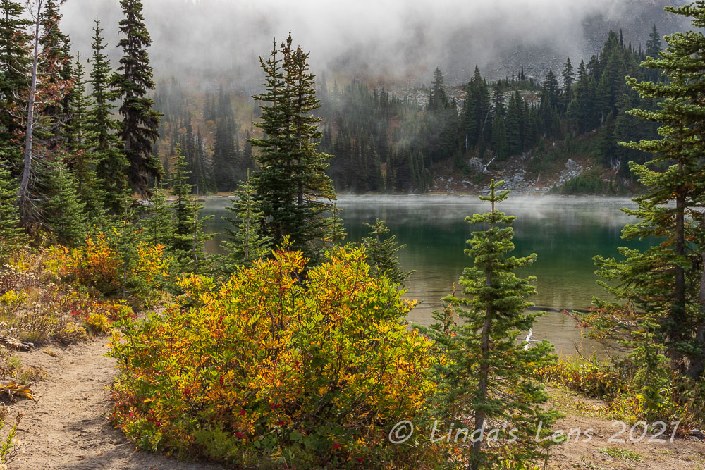
Fall color between the lakes

Dashing across Hwy 410 to the trailhead proper, the hike began by crossing Crystal Creek on a cute log footbridge.  That was the only flat spot - once past the bridge this trail took off on a relentlessly steep uphill gradient.


Stripes of color

I'd mentally prepared myself for the uphill climb and maintained a leisurely pace, allowing frequent rest breaks.  Normally hiking breaks happened when I stopped to photograph things, but this trail didn't have much of interest.  It was all boring, mossy forest for the first two miles.  Luckily the morning weather was chilly and foggy so I didn't have to worry about overheating on this uphill climb.


It looked as though someone had painted the underbrush

In 1.3 miles I came to a junction with the trail to Crystal Peak.  An additional 2.5 miles and 1800 feet of elevation gain would take me to the top of this mountain.  Although it was tempting, I realized this was even more distance and elevation gain than the trail I was already climbing.  Not needing to add to my misery, I decided to save that trek for another day.


Crystal Peak

Past the Crystal Peak junction the hike description mentioned a couple fleeting views of Mt Rainer through the trees.  However, the cloudy, foggy weather put a kibosh on that.  So onward I slogged through more dense forest.  I was getting tired of climbing without visual rewards.  Where was that first lake?


Crimson leaves

Just when I was beginning to wonder if I'd taken the wrong trail, a sign for Lower Crystal Lake came into view.  Finally!  Happily I veered onto the side trail to the lakeshore and enjoyed a short stretch of downhill grade.


A pop of color next to the trail

Lower Crystal Lake was lovely.  Rimmed by golden grasses, it's jade-green water was bounded overhead by craggy peaks.  The mountains kept disappearing into foggy clouds, giving the lake and it's surroundings an air of mystery.  Chatting with a backpacker who'd set up camp nearby I envied his campsite choice.  What a great place to spend an evening!


Upper Crystal Lake

But my journey wasn't done yet.  Another half mile further was Upper Crystal Lake, rumored to be even better.  So I tore myself away from the lower lake and resumed the uphill climb.  


Fog rising off the lake

After the fabulous fall color on the Sheep Lake - Sourdough Gap Trail, I was expecting the same here.  But the first two miles had been thickly forested with not much color at all.  That all changed in between Lower and Upper Crystal Lake.  Right away, I began seeing colorful huckleberry bushes.  Then orange-leafed mountain ash trees began to show themselves.  Through gaps in the forest I began to see clearings.  These treeless slopes were full of autumn hues of every shade.  So beautiful!  In addition, Crystal Peak began to poke it's summit above the trees.  The high overcast skies made the colors absolutely pop.  After 2 1/2 boring miles, my camera finally got some use.  There was too much to photograph!  It took me a long time to cover the half mile between lakes.


Mountain peeping over the Upper Crystal lake

Despite all the colorful distractions, I finally arrived at the shore of Upper Crystal Lake.  And, yes it was even more lovely than it's lower cousin.  Surrounded by tall, rocky peaks and slopes dotted with fall colors, the lake was breathtaking.  Fog hovered on the water's surface and drifted upward, temporarily obscuring nearby mountains.  One peak remained cloaked under clouds, but the others would peek in and out of their white curtains.


Colorful shoreline

A trail contoured around the north shoreline, so I followed it through technicolor meadows full of huckleberry bushes.


Lots of red huckleberry bushes

Such a gorgeous place!  Reaching the far end of the lake, I sat by the water and rolled out my lunch.  I entertained myself by watching the foggy clouds drift over the surrounding peaks and taking tons of photos.  Except for another man who'd hiked to the lake before me and had already left, I had the place to myself.


Rocky peak and colorful shore

Upper Crystal Lake was so lovely I didn't want to leave.  But after sitting for a good half hour, the day's chill was seeping into my body.  Time to get moving and warm up!  I reluctantly bid the wonderful lake and it's colorful surroundings a sad goodbye.  As a parting gift, the easternmost mountain, which had remained under clouds the entire time, suddenly threw back the white veil and revealed it's craggy slopes.  I took one final photo of this mountain's bare face before packing the camera away for the trek back down.


Dazzling meadow

The downhill journey wasn't a lot of fun.  After passing Lower Crystal Lake it was back to the moss-filled, uninteresting forest once again.  If that wasn't bad enough, my left foot began to hurt.  My hiking boots, now 3 years old, were wearing out, and the insole had bunched up under the ball of my foot.  The constant downhill pounding wasn't helping things.  I limped along (literally!) trying to lessen the pressure on my left foot. 


Lunch view

The return trip seemed to take forever, but finally I heard highway traffic and then the trailhead sign came into view.  After tackling the Crystal Lakes trail, I'd hoped to stop by nearby Silver Falls and explore the short path to this cascade.  But by now my left foot was throbbing, so I knew today's hiking was done.  Not only that, but I was physically tired from the steep trek.  Like the previous day's hike, I had to remind myself that it was only three short months (in September that is) since my brain surgery and my body was still very much healing.


Upper Crystal Lake pano

But on the plus side I'd been able to hike all the way to Upper Crystal Lake, 2600 foot elevation gain and all!  And although tired and sore, I'd survived.

Afterwards, looking at a map I found out that these two lakes were also accessible from the PCT via Sourdough Gap, the hike I completed the first day.  If I had kept on going north from Sourdough Gap, I would've eventually reached Upper Crystal Lake.  Something to try next time!


A final view before heading back down the trail

Although the first couple miles was awfully boring, the Crystal Lakes trail redeemed itself with two beautiful lakes and several mountain meadows full of autumn color.  The steep uphill trek was the price of admission to this special place.  Beautiful places in nature don't come free.  But the effort to get there is always worth it.


(P.S.  My car and it's contents were untouched.  I guess the thieves take Wednesdays off!)