Sunday, July 31, 2011

Rhodie-Oh!

My friend John goes hiking almost every weekend.  I hadn't hiked with John for awhile, so decided last Sunday to join him and his group.


Rhodie sighting!

John's trail of choice for the day was Devil's Peak via the Cool Creek Trail.  I'd hiked this trail once before about five years ago, and didn't remember much except that it was steep and boring. That, and I'd accidentally set my altimeter watch to "meters" instead of "feet" and thought the climb would never end!  When John first suggested visiting this trail I wasn't super gung-ho. But it's a good climb, and the old fire lookout tower that's at the top is really cool, so in the end I decided to come along.


Beautiful forest

In addition to John and myself, Young and John (another John!), a married couple who are friends with John #1, were part of the group for today.  And of course I brought my doggie Bear, who I didn't dare leave at home.


Beargrass puffball

The Cool Creek Trail gains 3200 feet of elevation in four miles.  The grueling climb starts right from the trailhead, and hikers immediately find themselves switchbacking up through the thick forest.


These rhodies caught a ray of sunshine

Instead of lugging my DSLR up the mountain, I decided to bring my little point and shoot camera. I reasoned there really wasn't that much to take photos of on this trail anyway. Why carry the big heavy camera?


The wonderful forest

Well......I soon regretted that decision.  About a mile or so up the trail we ran into rhodie-land and beargrass-ville!  Rhodies were blooming everywhere, and stalks of poofy beargrass lined both sides of the trail. It was the best display of beargrass and rhododendrons I've seen yet this year. Our forward progress came to a grinding halt, as everyone pulled out their cameras and began shooting.

Unfortunately, the mid-day light was terrible for photography. My point and shoot was no match for these challenging conditions, and my photos showed it.  About this time I was really wishing I would've packed my big camera.  Oh well - TGFP (thank goodness for photoshop)!


Mt. Hood - ta da!


Finally my group tore ourselves away from the wonderful flower fields and continued up the trail. We climbed and climbed until we were very close to the summit.  John, who has hiked this trail many times, knew of some little clearings off the main trail. He led us through the bushes to an especially nice one.  There before us was a drop-dead gorgeous view of Mt. Hood.  Time for another photo session!


This butterfly posed for one shot

Not far from the wonderful clearing, we hiked through a meadowy area filled with flowers. A butterfly was flitting around, and John and I attempted to catch it with our camera shutters.  I was lucky enough to capture a photograph when it landed on nearby flower.


Approaching the lookout tower

All the extended photo sessions of rhodies and butterflies took its toll, and it seemed to take a long time to reach the top. But we finally climbed the final pitch, and there was the top of Devil's Peak, and the old fire lookout tower.


Devil's Peak lookout

Another group had been camping in the tower, but they were just leaving as we walked up, so we ended up having the place to ourselves. The lookout building is very well preserved. I'm told it is maintained by a "friends of" group. It was well stocked with firewood and had furnishings inside. What a great place to spend the night.


Can't beat the view!

And best of all, there is a killer view of Mt. Hood from the doorway.


Lunch with friends

We were all set to have lunch at the lookout tower, but our leader John had other ideas.  He led us downslope past the tower until we came to a ledge overlooking the entire Salmon Creek drainage.  We could see Mt. Jefferson off in the distance. It was a commanding view of the entire area.  Yes, this was a much better lunch spot.


Me enjoying the views from the tower


After a great lunch, we stopped by the lookout tower for photos and exploration.  With views like these, I think I could handle being stationed out here for the summer.  It is really great that some of these old fire lookouts have been preserved for future generations to enjoy.


Another flowery photo session


After soaking in the views, we headed back down to the trailhead. We all made a pact to keep our cameras in our packs for the trip down. Well....that lasted about five minutes!  Leader John came across some flowers he just had to capture, and then all bets were off.  By the time we passed through the rhodie zone again, everyone's cameras were out!  So much for good intentions.


John finds a new comfort

On our way up the trail that morning, my group had heard a baby crying.  A couple of minutes later, we met some people coming down the trail, and one man had a small baby on his back.  We didn't think another thing of it, until on the way down, John discovered a pacifier in the trail.  He attached it to his pack and jokingly said he'd give it to the next person caught whining.


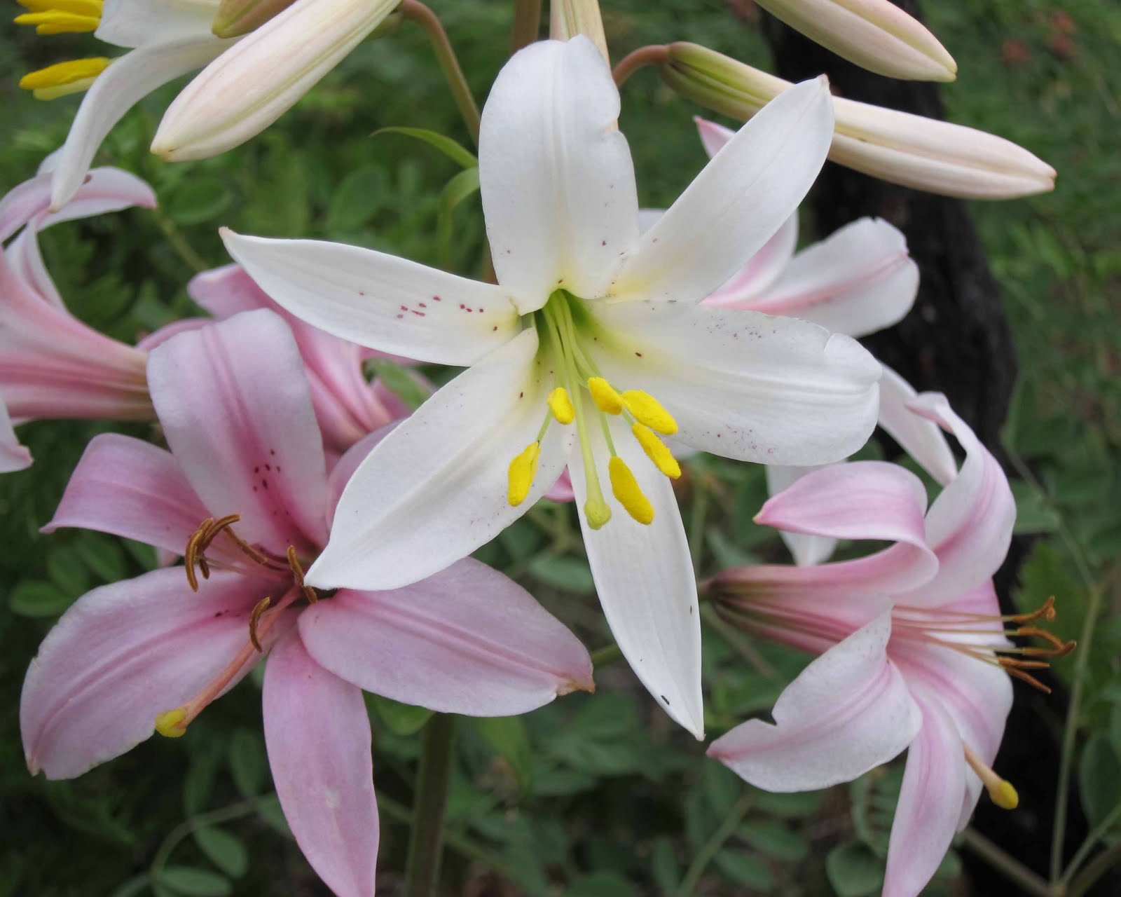
Lily photography is a group effort

Near the end of the trail John spotted a couple of Cascade lilies.  I'd seen my fill the week before, and didn't feel the need to photograph any more.  But John attempted to get a couple shots, and Young helped him out by holding the flowers in position.

This trail redeemed itself to me big time! We had a great day, and got to see a wonderful display of wildflowers.  And next time I'm bringing my good camera!

:)

Wednesday, July 27, 2011

The Rain Escape

The weekend before last rain was forecast for the Portland area.  Yes, rain - in July!  (We really haven't had much of a summer yet here - but that's another story).  Of course this had to be the same weekend Roger and I chose for our first backpacking trip in two years.


Gotta get a trailhead pic!

Since we hadn't backpacked for awhile, I wanted to pick a trail that wasn't too long or hard.  I also was hoping to bag another new hike from Sullivan's book.  And, of course, if I could find someplace away from rainy Portland, so much the better.


Ball Point rises from the sagebrush

I'd always wanted to hike up Ball Point, located east of Mt. Hood in the Badger Creek Wilderness.  The trailhead is a long drive from Portland, too long for a dayhike (which was the main reason this hike wasn't checked off in my book).  It looked easy enough for two novice backpackers, and since it was on the east side of Hood, we stood a better chance of escaping the "liquid sunshine."  So Roger and I decided Ball Point was to be our weekend's destination.


Top of the saddle

We arrived at the trailhead shortly after noon on Saturday, and were soon sweating under the sunny skies as we climbed towards Ball Point. The trail started out in a sage-brushy grassland punctuated by a few scraggly oak trees.  We climbed through that zone into a burned-out forest of ponderosa pines.  A large forest fire swept through this area in 2007.  Although the plant life is rebounding, there are still lots of blackened trees - stark reminders of the great fire.


Eastern Oregon panorama - click on photo for a larger view

There is a saddle viewpoint about a mile from the trailhead, that offers great vistas of eastern Oregon.  Roger and I huffed and puffed up a steep slope that led us to a grassy, clear knob just below Ball Point.  What a glorious view we had!  A panorama of eastern Oregon stretched out before us.  We could see forests and the farmlands beyond.  If the sky hadn't been so cloudy, we could have seen the mountains of central Oregon.  However, even without the mountain views, it was a grand sight.


Crossing a blow-down
 
From the saddle, the trail wound around the north side of Ball Point.  We entered into the woods (what was left of them).  A few flowers were blooming, but most looked like they were past their prime.  Oh well, at least it wasn't raining.


Stunningly beautiful Cascade Lilies

Then we ran into a group of dayhikers returning to the traihead.  After exchanging "hellos," a man in the group informed us that further down the trail a bunch of Cascade lilies were blooming.  He told us it was the best display he'd seen of these flowers.  Excited, Roger and I bid the group goodbye, and continued our hike.


Plant life rebounding from the fire

It wasn't much further and we ran into lilyland!  The lovely flowers lined the trail on both sides. The Cascade lilies were absolutely exquisite.  Some were creamy white, while others were a beautiful shade of pink.  And the blossoms emitted a wonderful aroma.  There was lots of photography happening.  As a matter of fact, I think half of the photos we took on this trip were of those lilies.


Roger at the helispot

During our extended lily photography session, the sky began to cloud up.  Roger and I suddenly noticed some dark clouds hovering over the northern sky.  And off to the southeast, a big thunderhead cloud was beginning to build.  Oh-oh, this didn't look so good!  Time to get moving.


View to the east from the helispot

We followed the trail as it led us to the other end of Ball Point.  Thunder began to rumble from the clouds.  With most of the trees burned, the forest was pretty clear in this area.  Not a good place to be in a lightning storm.  Roger and I upped our pace, hoping to pass through this area quickly before anything happened.


Abandoned miner's cabin

About four miles in, we came upon a helispot, a large cleared area that is designated for helicopter landing. There were some great views from this point. But by then, the storm clouds were gathering, and the thunder was still booming.  Roger didn't think this was a good place to hang out at the moment, so we continued on to find the campsite that was supposed to be nearby.

Our humble camp

As it turned out, the campsite was not very far from the helispot.  It was a nice spot, with tree canopy and a small firepit.  We had partial views of the eastern Oregon plains.  I located the spring that my guidebook said was nearby.  A trail downhill from the campsite led to a cute mossy glen with a burbling spring.  But the best part?  We had the place all to ourselves.


Good ol' box wine - a camper's friend!

After we'd unpacked and set up the tent, my hubby took off his boots and discovered two large blisters on his feet - one on each heel. He'd suffered in silence the entire climb up to the campsite. He was for sure done hiking for the day.

A toast to a great day in the woods

I however still had some energy.  My guidebook described a hike down the nearby Little Badger Creek Trail to an old abandoned mine and cabin.  Someone on the Portland Hikers website had recently visited this place, and posted photos, which got me intrigued.  I decided to go down the Little Badger Creek trail in search of this old mine. The thunderstorms that had been threatening us seemed to be heading away from our little camp, so I was no longer worried about getting rained on (or worse).


The next morning - packed up and ready to hit the trail!

The trail down to the mine was a steep downhill ramble. I traveled about a mile before coming upon the old cabin.  I located the mine, a nondescript hole in the side of a hill.   I thought about exploring, but remembering one of the photos from the Portland Hikers website of a rat inside the tunnel, I decided not to venture inside. The half tumbled-down cabin was very interesting. It looked to be made of sturdy logs which were sun-bleached, but intact.  Weathered remnants of furnishings were scattered about.  I'm not sure of the story behind the mine and cabin, so I don't know how long it's been sitting idle.  An interesting slice of history tucked deep in the wilderness.


Another lily photo

But the uphill trek back to the campsite was not very fun!  By now the storm clouds had moved on, and the sun was out.  It was a hot strenuous climb back up that trail.  I returned to camp tired, thirsty, and ready for dinner.

Climbing back over the tree

Roger got some water boiling for our "wonderful" dehydrated meals.  I broke out a small box of chardonnay, that I'd carried in my pack, and a few pieces of wax-coated cheese (which held up really well considering the warm day).  So while waiting for the water to boil, we had our own little happy hour right there in our camp, complete with wine and cheese!

Cascade lilly photo op

Roger and I were both tired from our day's hike, so we retired early to the tent.  The night was amazingly silent - almost kind of eerie.  We live very close to a freeway, and I didn't realize how much I'm used to background city noise.  It was almost too quiet to sleep.


Creamy white lily flanked by it's pink sisters

But sleep we did, although I did wake up several times in the night.  I learned one thing I'll do different for the next trip - I'm purchasing a good Thermarest sleeping pad.  The cheap, crummy pad I used was useless.  I might as well have slept on the ground.  The aches from my back and hip kept me up intermittently throughout the night, and ruined what would've probably been a decent night's sleep.  Live and learn.

Burned out forest coming back to life

Roger and I awoke to cloudy skies.  A couple of passing light showers left sprinkles of rain on our tent, but the morning was dry.  We had a leisurely breakfast, then stuffed everything into our packs for the hike out.  We had a quick trek back to the trailhead, save for a few more Cascade lily photography sessions.


Fireweed

As my hubby and I hiked out, the clouds began to thicken. The skies were looking threatening again, but we managed beat the rain back to the trailhead.

Imagine our surprise as Roger and I drove home, when we encountered torrential rain in the Gorge. We found out later it had been pouring in Portland all morning.  I learned that most of the popular hiking trails nearer to Portland had been rainy and wet all day Sunday.  We really lucked out.  Not only did my hubby and I escape the rain, we visited a place that afforded views, stunning flowers, and solitude.  A successful first backpacking trip!


:)

Friday, July 22, 2011

Misadventures in Hiking

OK folks, it's time for a return to my regularly scheduled hiking tales.  I'm still playing catch-up from my vacation, so this story is from two weeks ago.

As I've mentioned before, one of my long-time goals is to hike all of the hikes in William Sullivan's "100 Hikes in Northwest Oregon" book. After 10-plus years, I've whittled the list down to about a dozen left to explore. Two weeks ago I decided to check another hike off my list, and chose the Old Baldy trail as my day's destination.

(Click on any photo for a full-size version)

Bear, always up for a hike!

This trail looked good on paper.  It was a fairly short drive from home, offered an opportunity to bag two summits in a day (Old Baldy and Squaw Mountain), and best of all, the drive to the trailhead was entirely on paved roads!  Bear and I loaded into my Subie, and headed for the hills.


Lovely green woods

After a little searching, I found the unmarked parking area that was the trailhead.  Shortly after I'd parked, another car with two ladies inside showed up.  We exchanged our "hellos" and started towards the trail together.  Not far from the road we came upon a nice new sign that announced the Old Baldy trail.  I, of course, stopped for a photo op, and was left behind.


Rhodies in bloom

No matter, it was a beautiful day, and I was enjoying my solo trek through this lovely forest.  The rhodies were just beginning to bloom along the trail, and I was able to get a few photos of their pink blossoms. There were also a couple of Beargrass plumes beside the trail.  I'd rambled on for awhile when, it suddenly dawned on me that I had been hiking downhill for quite some time.  Hmmm...... the trail was supposed to climb up to a mountain wasn't it?  I continued on thinking I'd surely begin climbing soon. After walking a little bit further, I came upon the two ladies sitting on a log having a snack. They asked me if we were on the right trail, since all we'd been doing is going downhill. About that time I was beginning to have my doubts.  I whipped out my map of the area. In addition to Old Baldy and Squaw Mtn, the map also showed a trail called the Eagle Creek Cutoff.  It appeared to switchback downhill to a creek. I began to wonder if we were on the wrong trail.


Rhodies showing off their pretty pink blossoms

But the ladies and I both decided to go just a little further to be sure. We started out together for a few minutes, but then I saw something I wanted to photograph, so my companions continued on without me. The trail began to switchback down hill very steeply. About that time I decided this couldn't be the right trail - it didn't look right at all.  It had to be the Eagle Creek Cutoff. Where had I gone wrong? I decided to retrace my steps back towards the parking area, to see if there was a trail junction I'd missed.


This sign is not right!

The unfortunate thing was that what goes down must come back up. I had to trudge back up all that steep hill I'd been happily waltzing down. I had no idea how much elevation I lost, but it was a lot. And it was quite a slog back up! About halfway back to the trailhead, I took a break and downed a PB&J. I was just about done with my lunch, when the two ladies came puffing up the hill. Apparently they'd made it all the way down to the creek, and from that point the trail was impassable due to high water across the path. After hearing their story, I knew for sure we'd picked the wrong trail. We had to be on the Eagle Creek Cutoff.


Another incorrect trail sign

I huffed and puffed back up the hill, all the time looking for any trail I might have missed. I ended up back at the "Old Baldy" trail sign and didn't see a thing. I looked all around the sign, searching for another trail, but there was none to be found.

Back at the trailhead again... It was only two o'clock in the afternoon, and I hated to head home so soon. Since I'd been skunked trying to find Old Baldy, I decided to try for another summit. Sullivan's book said Squaw Mountain was only a little over 2 miles from the same parking area. That seemed do-able.  I knew I could make it there and back before it got too late.


Avalanche lilies

Sullivan's book and my map indicated the location of the Squaw Mtn trail to be south of the parking area. I saw a trail in that general direction and headed towards it. Imagine my surprise when the sign adjacent to this trail read "Eagle Creek Cutoff - TR No. 504." That wasn't right at all!  Not again!

By this time I'd lost faith in these trail signs, and followed the path anyway.  When I met up with a junction that was noted on my map I knew I was on the right trail for Squaw Mountain.


Trail sign in the middle of a snowfield

Past the junction all of a sudden the trail disappeared under a large amount of snow. Uh-oh, where was the trail now? I pulled out my gps for guidance.  Bear, who seems to have a nose for finding the way, darted on ahead. I followed my pup and lo, and behold he was waiting for me on the other side of the snowdrift, and there was the continuation of the trail.


Traversing a snowy slope

From that point on, the trail was intermittently snow covered. I relied on my gps to keep myself moving in the right direction and followed some faint footprints in the snow.  The snow was so deep in places, I had to kick steps and climb a couple of times.  Afraid of getting lost, I considered turning back.  But not wanting to fail a second time, I pushed back my fear and continued on.


Killer summit view

The trail intersected with an old road.  The footsteps in the snow continued along this road, so I kept following.  Not far from the junction, the forest above me seemed to be clearing.  It looked like the top of something.  Shortcutting the road, I plowed straight through the snow towards what looked to be a summit.  As I pulled myself up the final pitch, I saw a set of old steps to a lookout tower.  Mt. Hood appeared above the trees.  This was it.  I'd made it to the top of Squaw Mountain!  Success!


Mt. Hood extreme close-up

There was an absolutely stunning view of Mt. Hood from Squaw Mountain's summit.  The sky was clear enough to see the mountain in all her glory.  It was wonderful to sit back and enjoy the views I'd worked so hard for.


Benchmark on top of Squaw Mtn.

There was a bunch of cool old relics from a lookout tower that used to sit atop Squaw Mountain.  The concrete steps and foundations from the tower were still standing.  I also found an old benchmark among the rocks.


Vibrant orange paintbrush

There was even some flowers blooming on Squaw's summit.  A bright orange patch of paintbrush, and bunches of pretty violet phlox squeezed themselves out from between the rocky, gravelly surface.


Lovely phlox flowers

Upon my return to the car, I happened to notice a very faint trail heading off to the north from one side of the parking pullout. Could this be the Old Baldy trail? I followed it for a little ways, and it appeared to be heading in the correct direction.  I was really curious, and wanted to see where it went.  However, it was getting late, and the uphill climb had done me in. I decided to save it for another day.

So even thought I failed in my attempt to reach Old Baldy, I was successful in bagging another peak. And I had an adventurous walk through the snow!  My hiking misadventure had a happy ending after all.


:)

Wednesday, July 20, 2011

A Historic Meeting

My brother Ron has been married to his wife Tonya since 2002.  In all that time, Tonya has never met my hubby.  I know that sounds strange, but the times I've visited Ron and Tonya, Roger has always had a conflict, and wasn't able to make the trip.  Ron and Tonya have never been out to Oregon to see us (but they have three young boys, not exactly easy travelers).

Tonya would always tease me about Roger.  She'd say "Are you sure your husband is for real?  How do I know he exists?"  One time I had Roger talk to Tonya on the phone, just to prove that he was an actual person.  After he'd finished, I got back on the line and Tonya asked me "Who is the actor you hired to be your husband?"  Roger, for his part would tell me "How do I know Tonya exists?"  It became a running family joke. 


Together at last!

 But with the date of my parents 50th anniversary party nearing, it looked like the planets would align for a historic meeting between brother- and sister-in-law.  Roger commented that it would be Murphy's law he'd be called to China at the last minute, or Tonya wouldn't be able to come.

But both parties made the trip, and the two family members, once strangers to each other, were finally able to meet.  My brother Ron was on the ball, and captured the event on video.  (I, however, didn't even think to have my camera at the ready and missed a photo op of the entire thing!)

Not only was Roger introduced to his sister-in-law for the first time, he also got to meet all three of their boys.  Roger has an uncanny resemblance to the cartoon character Mario, of the Mario Brothers video game.  Many people have commented on this similarity.  Our nephews immediately picked up on Roger's look-alike, and from that moment on, Roger became "Uncle Mario."  As a matter of fact, by day four he'd been promoted to "Uncle SUPER Mario."

So Roger and Tonya are no longer strangers.  Hopefully there will be more opportunities for them to get together again.  Tonya, you need to come out and visit us in Oregon next year!

:)