Saturday, April 23, 2022

Make Way for Ducklings!

In mid-April I start scanning our local parks and ponds for signs of baby waterfowl.  Where I live, we're lucky to have two public parks within a mile of our house.  Besides having play structures and sports fields, both parks have created wetland areas for the local wildlife.  In addition to birds of all species, lots of ducks and geese hang out in both parks.  In the springtime, we always spot broods of baby ducks clustered around their mothers near the waterways.  I love to see the tiny, fluffy ducklings swimming after mama duck or trotting through the grass.


Hiding under mama duck


My hubby, who is still working from home, has established a daily routine of a lunchtime walk through our neighborhood.   For the past two weeks, he's spotted ducklings in the park on his daily walks.  However, when I later visit the same location, these babies are nowhere to be found.  (I've taken to nicknaming hubby the "duck whisperer.")


Fluffy cuteness


Last Monday was a particularly rainy day.  But hubby walks rain or shine, so he suited up in raingear and completed his daily neighborhood circuit.  Upon returning, my hubby excitedly told me he'd encountered another flock of ducklings and they'd walked right under his feet across the park pathway.


Taking her babies out for a swim


Well, I was tired of being skunked.  Rain or not, I decided to head over to the park immediately to see if I couldn't find those ducklings.  Not willing to walk with my big lens, I drove my car to the park.  From the parking lot it was a short walk to the path and pond, the location of hubby's most recent duckling encounter.


Just ducky!


At first I didn't see anything.  I thought, "Oh darn, I missed them again!"  But walking around the pond I spotted a lone female mallard sitting in the tall grass.  It was a mama duck alright, but where were her children?  Then I saw something yellow and fluffy moving underneath her feathers.  The ducklings were all huddled under their mother and she appeared to be either hiding her brood or shielding them from the rain.  Such an endearing sight!


The ducklings found something to eat


Mama duck and I stared at each other for quite some time.  I kept my distance and shot a few images with my zoom lens.  After a couple of minutes the mother mallard must've tired of my attention as she stood up and started towards the pond.  Seven adorable ducklings tumbled out from underneath their mother and dutifully followed her to the water.


Jockeying for the goodies


Once all seven were in the water, they formed a line behind mom and started swimming away.  Not willing to let my photo subjects get away so soon, I followed the duck brigade from shore, snatching photos when I could.  The mom kept swimming one direction, and then another trying to evade me.  At one point, all the ducklings clustered around some vegetation sticking up from the pond bottom.  There seemed to be something the little guys liked as they all were pecking around the area.  Fortunately it kept the ducklings in one place just long enough for me to get a few good images.
 

Adorable little fluff balls


After ten minutes, I could tell the mother duck was getting tired of eluding me (and my camera was getting really wet) so I decided to make my exit.  But happy day - I'd finally got to see some ducklings!


A nearby Golden-crowned sparrow


On the way back to my car I noticed many sparrows flitting around a nearby row of bushes.  The birds were so close, I couldn't resist a few shots of these pretty little birds.  Later, I realized the birds were mostly golden-crowned sparrows, identified by a striking yellow blaze across their heads. 


Yellow-rumped warbler in our backyard


Finally, in the backyard bird department, we've been seeing several eye-catching yellow and gray birds at our feeders.  The birds were so beautiful, I spent the better part of several hours trying to capture the perfect shot of one.  Consulting our bird book, we identified the little guys as yellow-rumped warblers. 

I've spotted a few goslings in a nearby park, so my next photographic goal is to capture some images of these fluffy, yellow little ones.  Coming (hopefully) soon!

Monday, April 18, 2022

Cape Lookout

After choosing to hike with our mutual friend John instead of going to the Oregon Coast as originally planned, my friends Debbie, Barry and I were still hankering for a visit to the mighty Pacific.  So two weeks later, we decided to try again.  I suggested we explore the trail along Cape Lookout.  It had been many years since I'd hiked here and I remembered there were some fantastic ocean views at the cape's end.  


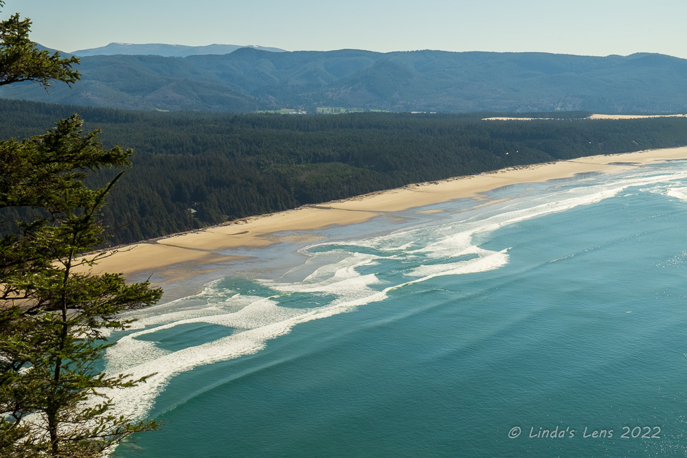
Beach view from the trail's beginning

It was an uncharacteristically cold and frosty morning as we left Portland.  Driving over the Coast Range, I encountered a bit of roadway ice on the higher reaches.  Once arriving at the trailhead, located in a state park bearing the same name, we were surprised by how chilly it was outside.  Temperatures hovered just below freezing - unheard of on the usually temperate Oregon Coast!  My friends and I pulled on all the layers that we'd brought.  Time to get moving and hopefully warm up.


A few peek-a-boo ocean glimpses between the trees


Cape Lookout is a long, narrow promontory of basalt that stretches over a mile and half into the Pacific Ocean.  The cape is a remnant of massive lava flows, it's steep basalt cliffs plunging 400 feet into the sea.  The top is heavily forested and it's base a popular nesting site for seabirds.  Originally considered for a lighthouse site, it was determined too foggy for such a use, and the land was later acquired by the state of Oregon for a park.

The Cape Lookout Trail began in a dense coastal forest.  After a quarter mile of downhill walking we began to see ocean glimpses through gaps in the trees.  Angling my camera through these openings I was able to capture a few halfway decent images of the coastline far below.  Although it was sunny, the weak sunshine did little to warm our bodies.  As a matter of fact, Debbie and I's hands were so cold we donned a second set of gloves.


Huge fern ball in this tree (?)

After the peek-a-boo ocean views, our trail veered away from the water and plunged into deep forest.  From here it would wind along the length of the cape, from one side to the other, before finally coming out at the very tip.  The trees here were primarily spruce and hemlock, some gigantic in size.  Ferns and salal covered the steep slopes.  In one tree we noticed a huge ball of ferns growing on a branch.  Something I'd never seen before, I took this photo and later tried to do a bit of online research to determine what it was.  But googling "ball of ferns on fir tree" didn't net any answers (it did however garner some very interesting responses!  A few not fit for this family-oriented blog....) 


Fern-filled slopes

One thing about this trail, it had a reputation for being incredibly muddy - even in the middle of summer.  I knew that hiking in the winter meant we'd encounter lots of boggy areas.  But due to the day's cold temperatures, the first muddy patch we encountered was almost entirely frozen over.  My friends and I tromped across the stiff, icy mud no problem.


Halfway viewpoint


The first major mud hole

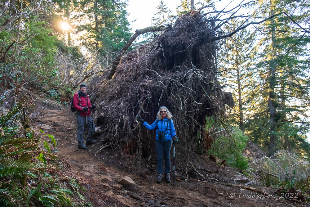
I thought "Maybe hiking this trail during colder weather is a good way to avoid all the mud."  But then we encountered something I didn't really expect - ice.  Our next obstacle was getting around a massive downed tree.  It's rootball had torn up the trail and hikers had tromped a steep, crude user path around it.  As my friends and I crept down this treacherous route we were surprised by a patch of ice, causing all of us to slip.  Only Barry actually fell, but luckily he wasn't hurt. 

The icy trail conditions caused us to pause.  Was the rest of this trail as slippery?  None of us wanted to risk a fall, especially knowing parts of the route were next to high cliffs.  We got mixed reports from a few hikers heading in the opposite direction.  One woman described trail conditions as extremely slick, while another man said there were "a few icy spots, but overall it was fine."


Three Arch Rock from viewpoint

Well, other people were hiking the trail and seemed to be doing just fine, so in the end we decided to continue on.  The day's temperatures were rising and we figured most of the ice would melt soon enough.  Not far from the downed tree we came to nice viewpoint.  We paused to take in some great views to the north.  I spotted the formation known as "Three Arch Rock" and Debbie and Barry identified Netarts Spit, a narrow sandy beach jutting out into the blue Pacific.


Netarts Spit from viewpoint

Continuing on, we came to our next obstacle.  The trail had washed out, leaving us to pick our way through a bunch of large, muddy tree roots.  Not only were the tree roots icy and muddy, they were also extremely slippery.  A slow, cautious shuffle was required to clear this latest mess.


More mud, root, and ice trouble

And waiting for us at the bottom of the tree roots was a huge bog full of mud.  Hoping to keep my boots relatively clean, I tried to follow the icy footprints in the mud, but things had thawed out just enough that my feet punched through the ice into the muck.


One could slip from either ice or mud

So much for clean feet!  After that experience, I decided it was probably safer just to go ahead and wade through the mud, instead of expending all the effort to dodge it.  I got plenty of chances to test my theory - there was much more mud and ice to come.


A brief rest by another big tree

Carefully inching through the numerous mudholes on the trail really slowed down our progress.  Dense tree cover kept the sun from melting much of the ice, so we never could tell if the mud was frozen until walking through it.  Not only the muddy spots, we also encountered several areas of exposed tree roots that required meticulous foot placement to avoid tripping.  None of us wanted to fall and wrench a knee or ankle.  Over some of the especially boggy portions of the trail wooden boardwalks had been placed, but a few of these walkways had fallen into disrepair.  And the wet, muddy planks were nearly as slippery as the mud itself.  


Ocean viewpoints became more frequent 

The trail to the very end of Cape Lookout is listed as 2.5 miles, but with our slow progress it seemed much longer.  After walking through forest for what felt like miles, our trail finally broke out of the trees at the top of a tall cliff.  Breathtaking views of the Pacific Ocean stretched to the south.


We made it to the end of Cape Lookout!

I began to get excited because from past hikes I remembered that once you saw the ocean it wasn't far to the cape's end.  Rallying my friends I told them that we didn't have far to go now.  


Pacific Ocean in the very bright sunshine

The final half mile still seemed to take forever.  But at least we had clear ocean views to buoy our spirits.  The trail traveled close to the edge of some very high cliffs providing splendid vantages of the sparkling water below.  Finally out of the shady forest, the sun warmed our faces.  One young lady we passed going the opposite direction excitedly told us she'd spotted whales from the tip of the cape.


Not much room to sit down

After crossing yet another extremely muddy trail section, my friends and I finally arrived at the very end of Cape Lookout.  Trail's end was a small, roped-off area bordered by a thick forest on the north and steep drop-offs on the south and west.  Two other parties were already in this cramped space so we made a seat on an adjacent rocky portion of the path.


We were entertained by a friendly song sparrow 

Lunch never tasted so good!  It was past 1 o'clock and my tummy was rumbling.  As my friends and I enjoyed our food, we were entertained by the antics of a friendly song sparrow and aggressive chipmunk.  Once the other parties left, both critters dashed over to where they'd been sitting, perusing the ground for crumbs.  The chipmunk was so fearless, he actually walked right up to the toe of another person's boot.  It was obvious he'd been fed by many a hiker.


A brave chipmunk also put on a show


It was so nice to sit in the sunshine and take in the wide ocean views, I didn't want to leave our lofty perch.  But we couldn't stay all day, so finally my friends and I packed our lunch remains away and bid the chipmunk and sparrow goodbye.  Time to trek back through the mud!


Back through the numerous tree roots

Now that we knew what to expect, our return trip was faster.  The day's rising temperatures had finally melted most of the ice, so we didn't have to be as cautious.  Our boots already muddy from the initial trek, we now splashed through the sloppy puddles instead of skirting obstacles.


Gigantic blow-down tree


As we passed by the huge blow-down tree once again, I made Debbie and Barry pose by the monstrous root ball for scale.  (If a tree falls in the forest and nobody hears it, does it make a noise?  I'll bet this one did!)


Lovely ocean views towards Cape Kiwanda

In 1943, an Army Air Force B-17 hit fog and crashed into Cape Lookout, killing eight crew members.  Near the trailhead, a plaque memorializing this event has been set into a rocky outcrop.  Somehow we'd missed this marker on our outward journey, so I made sure to spot it on our way back.  The plaque was located near a place where the trees part just enough to give hikers a view of Cape Kiwanda and Haystack Rock far to the south.


Shoreline beaches


My friends and I survived our cold trek through frozen mud to the end of Cape Lookout and back.  We all agreed our journey was more of an army basic training obstacle course than a hike - at least it sure felt like it!  But we all agreed it was a great adventure for a sunny winter's day.  And now we have bragging rights and a good story to tell.


Sunday, April 10, 2022

Before the Flowers

I used to hike quite often with my friend John.  A co-worker at the time, we had cubicles next to one another for six years and became good friends.  John was an avid mountaineer who was very active in the local mountain climbing club.  Nearly every weekend he would plan a group hike and send out an email invitation to a number of people.  I met quite a few of my hiking friends from John's planned outings.  

But several years ago John retired.  We kept in touch, but his weekly group hike invitations dwindled.  I think he got burned out from always being the event planner (not that I blame him).  Then two years ago COVID happened, and I lost touch with many of my friends, including John.


Mt Hood bids us "Good Morning"

My hiking buddies Debbie and Barry are mutual friends with John.  We'd chosen a Wednesday in early February to hike a trail at the coast, when Debbie called me and said she received an invitation to hike with John on the same day.  She asked if I'd be interested in joining John's hike instead.  Although both Debbie and I had initially wanted to go to the coast, we both decided we'd rather hike with John since it had been nearly two years since either of us had seen him.


Hidden waterfall

John's trail of choice was the Crawford Oaks loop through the Dalles Mountain Ranch.  Known for it's spectacular April wildflower displays, it was someplace I usually didn't visit any other time of the year.  Certainly not in February!


Many rock layers of the Columbia River Gorge

But the real reason for the hike was to see John, so I was agreeable to any trail.  Debbie, Barry and I carpooled to the trailhead, in the far eastern reaches of the Columbia River Gorge.  The Dalles Mountain Ranch is part of Washington State's larger Columbia Hills State Park.  It was a beautiful sunny morning as we pulled into the trailhead.  Getting ready, I marveled at the stunning views of Mt Hood from the parking area.  A short climb from there gave us even better views of both the mountain and layered rocky cliffs surrounding the Columbia River.


My companions walking uphill past the woodpecker trees

In addition to Debbie, and Barry, John's girlfriend Dorene joined us.  It was so good to see them both!  We climbed an old road up a steep hill past a grove of gnarled oak trees and discovered the trees full of Lewis woodpeckers.


Find the woodpeckers

My friends are all avid birders, and at the first sight of the woodpeckers pulled out binoculars for a better look.  The birds flew and dove around the trees, and sometimes landed low enough to spot with a naked eye.  But not close enough for me to get a good photo with my puny 24-105 mm lens.  About that time, I was really wishing I'd packed a long zoom!


Great views behind us


Beyond the woodpecker trees, our trail wound steeply uphill to the top of a plateau.  The views from here were first-rate.  Mt Hood anchored the western skyline, while the Columbia River's long blue ribbon spread out in both directions.


Always in the rear, this was my view


My friends and I climbed one final hill which brought us to a stunning view of the Columbia River looking east.  We made a quick photo and snack stop, but gusty winds blowing off the river kept our break short.


Columbia River overlook


A cold wind continued to blow as we turned away from the river and began trekking through rolling hills towards the ranch.  Nearly all of us switched our headgear to something much warmer.  Debbie and I even donned gloves.


Warning sign!


Our trail brought us through the famous spring flower fields of the Dalles Mountain Ranch, now covered in brown grasses.  It was interesting to see what the ranchlands looked like without their spring blooms - and hard to believe these fields would be bursting with yellow and purple petals in just two short months.  (For a sample of the flowery goodness, check out this past blog post from 2016)


Old buildings of the Dalles Mtn Ranch


Our trail finally intersected with the gravel ranch road.  Following the road brought us to the abandoned buildings of the Dalles Mountain Ranch.  John said there was a picnic table by one of the buildings, and suggested we stop there for lunch.


Windy lunch break


It's always great to have a table to sit at and eat instead of plopping ourselves on the ground, so everyone was agreeable to John's idea.  We enjoyed a nice break gathered 'round the picnic table, even though the wind (still blowing strong and cold) kept us bundled up the entire time.


More old ranch buildings


Tummies full, it was time to complete our loop.  John wanted to take us past the famous old car, a popular subject for photographers when the flowers were blooming.  So we trekked overland, past an old barn and through a field, dodging numerous cow patties (apparently they still run cattle on the ranch!)


Setting out after lunch


On top of a small hill, our group followed the fenceline to an opening in a gate.  Past this gate was the pasture where the often-photographed car lay in rusty repose.


No flowers here yet


Having photographed this decaying Studebaker during peak bloom many times over the years, it was weird to see it not surrounded in yellow flowers.  The barren hillside looked rather dull and ugly.  But of course John and I couldn't resist taking a few pictures for posterity.  (For photos of the car with flowers, check out some of my past blog posts here and also here.)


The old car looked lonely without it's flower fields


After paying our respects to the car, John led us downhill towards the main trail.  At least that was the plan - until we discovered our route blocked by a newly-installed barb wire fence.  But it didn't stop our group.  We took turns lifting the wires to create a large enough gap for everyone to shimmy through. 


Fence crossing


A quick cross country jaunt through an oak grove and across a tiny creek brought everyone back to the main trail.  


Creek crossing


Now reunited with the main trail, it was just a matter of following the rolling hills a couple of miles back to the parking area.  The lack of trees made for some fantastic sweeping views of the surrounding area.


Group photo 


When hiking with a group it's always fun to walk with each of the different people and catch up.  On return trip I buddied up with John and we updated each other on the happenings in our lives.  John said he'd been having knee issues the past year and been in and out of doctors offices, trying to determine a fix.  He now had to wear a brace on one knee and was limited to shorter, less steeper hikes.  Although it was hard for him to slow down, at least he could still hike.  John turned 75 this past year and after all the mountain climbing, skiing and hiking he'd done throughout his life, I told him he was lucky his knees had held out for so long.  I sure hope I'm still hiking when I hit 75!


Winding back uphill


After a few ups and downs and another creek crossing, my friends and I ended back at the woodpecker trees once again.  There wasn't as many birds as the morning, so no one lingered this time.


Tremendous Gorge view on our return trip


Besides, it was getting late and we all had "horse in the barn" syndrome.  We hustled over the final mile, eager to get to the trailhead.  Hiking back down the final gravel road, we were all treated to some grand views of the Columbia River and rocky cliffs of the gorge.


Almost to the parking lot!


It had been a spectacular day to hike through the wide-open grasslands of the Dalles Mountain Ranch.  Back at the trailhead, we all agreed John had picked a great trail for the day's hike.  But the real treat was catching up with an old friend.  Hopefully it won't be another two years before we hike together again!

Although I do a lot of hikes solo, a trail is always better when shared with friends.