Wednesday, June 29, 2022

Triple Falls

One of my favorite Columbia River Gorge hikes is the Triple Falls Trail.  I've always felt this trail gave hikers the best "bang for a buck" in regards to the number of waterfalls vs the short distance traveled.  Sadly this entire area was badly burned in the 2017 Eagle Creek wildfire, and the trail to Triple Falls remained closed for many years after.  But happily, the Forest Service finally reopened this trail in the spring of 2022.  Hearing Triple Falls was again open for visitors, I convinced my friends Debbie and Barry to join me for a look-see.


Horsetail Falls

So one fine day in early May had my friends and I driving to the trailhead parking area, at the base of lovely Horsetail Falls.  At 176 feet this stunning cascade shot out of a basalt cliff and spilled over its mossy face into a large splash pool.  After spending an appropriate amount of time taking photos and admiring the gushing waterfall, we headed towards the trailhead, a stone throw's east of Horsetail Falls. 


Tons 'o bleeding heart flowers

But before we could start up the trail my friends and I were stopped cold by a colorful display of wildflowers.  Pink bleeding hearts bloomed profusely near the trailhead sign, accompanied by a huge number of fringecup fronds.


Fringecup

Cameras and cell phones came out and a frenzied photography session ensued!


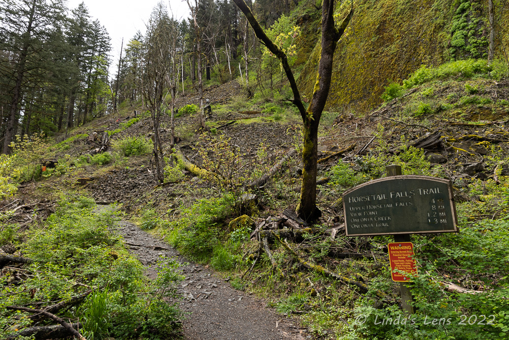
The trailhead looks so barren and sad after the fire

Floral photos safely tucked into memory cards, it was time to tackle this trail!  From the trailhead sign, the tread wound uphill through a barren area, completely logged of fire-scorched trees.  Remembering how lush and green things used to be pre-fire, it was a sad sight.  


Fairy bells

But burn zones create rich soil for re-establishment of plants, and I was cheered to see the trail ahead lined with wildflowers of all varieties.  
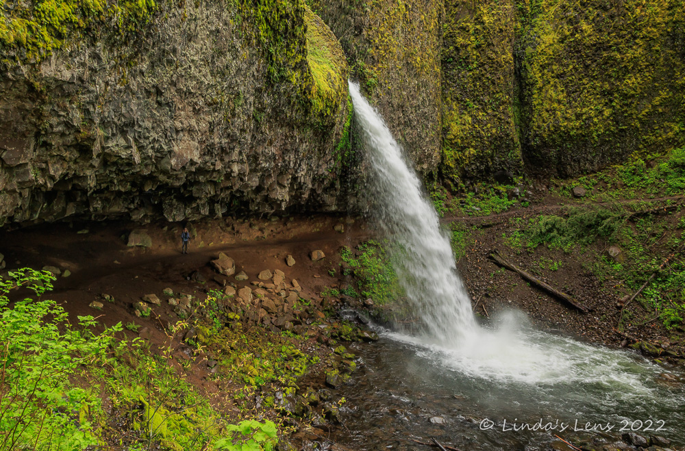

Ponytail Falls

After a half mile of climbing we came upon our first waterfall, charming 80-foot tall Ponytail Falls.


Can you spot Debbie to the left of the falls?

This waterfall was fun to visit because the trail ran right behind it. (Can you spot Debbie to the left of the falls?)


I love waterfalls that you can walk behind

Is there anything more enjoyable than walking behind a waterfall?  Some of my favorite cascades are the ones that you can view from a different perspective.


Debbie and Barry on the trail

After much more photography and general gawking, we took the uphill trail away from Ponytail Falls.  It traversed below some tall cliffs and through talus slopes.  Although also heavily burned in the fire, bushes and wildflowers had grown back in great numbers.


Serviceberry blooms

The amount of green definitely outnumbered the bleak, burned trees.  And that was a good thing.


Fantastic gorge viewpoint

A quarter-mile past Ponytail Falls, my friends and I took a short side path leading hikers to a breathtaking clifftop Gorge panorama.  The Columbia River stretched out for miles in both directions.


Switchbacking down to Oneonta Falls

Beyond the viewpoint, it was back into what was left of the forest, switchbacking down to Oneonta Gorge and waterfall.


Narrow Oneonta Gorge

Oneonta Gorge is deep and narrow between this trail and the Scenic Highway and boasts spectacular scenery.  Before the 2017 fire, it was wildly popular to wade up Oneonta creek from the highway.  Thanks to social media, Oneonta Gorge began to draw hundreds of daily visitors during the summer, and as a result was getting trashed by the masses.  Then the 2017 wildfire severely damaged this area, forcing its closure.  Oneonta Gorge has not yet reopened, and I suspect the Forest Service may keep it shuttered for many more years to come.


Oneonta Falls

A bridge crossed Oneonta Creek and gave nice views of 60-foot high Oneonta Falls.


The trail above Oneonta Falls was mighty bleak

Then it was time to climb once again!  From Oneonta Falls my friends I crawled up the opposite side of its canyon.  The day was beginning to warm up and I started to sweat from the exertion.  


A little color in the burn zone

At a junction with the Oneonta Trail, my friends and I turned northward, towards Triple Falls.  The trail followed the opposite side of Oneonta Gorge and continued to ascend, sometimes steeply.  In many places we were navigating a path perched on the side of steep cliffs.  The creek was a long ways down!  I'd heard that due to numerous landslides, this portion of the trail was especially difficult to reconstruct after the fire.


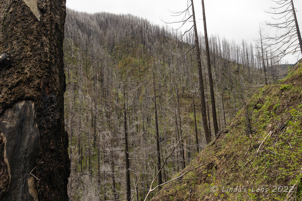
Sad to see the destruction

The fire's destruction was especially intense here.  Acres of blackened tree trunks covered the slopes above Oneonta Creek.  Vegetation seemed to just recently be reestablishing itself, but I did notice several colorful spots of wildflowers.


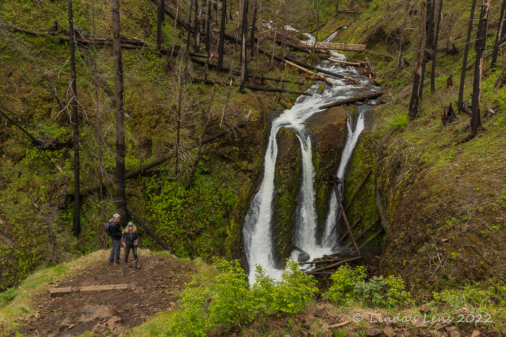
Finally - Triple Falls!

It was nearly a mile from the Oneonta trail junction to Triple Falls, but walking uphill through the burn zone if felt much longer.  Having not hiked in this area since 2015, I was trying to remember where exactly the falls were located.  Were they behind this bend?  Nope.  This one?  Nada.


Triple Falls 2022

But finally we rounded a corner, and there was Triple Falls in all it's churning water glory!  Hooray!  The falls can be viewed from an overlook perched precariously on a small cliff jutting over the creek.  There's no guardrail, so visitors must watch their step.  But it gives one a front-row view of this stunning, three-pronged cascade.  Debbie, Barry and I decided it made a great lunch spot.


Triple Falls 2015, before the fire

Although Triple Falls was still as impressive as ever, I was a little sad to see the fire damage above and around it.  The area used to be so lush and green and now it looked brown and bare.  Back home, I dove into my photo archives to find some pre-fire images of the area.  I posted one above so you can see the difference.


Debbie tries out the new footbridge

After eating lunch, Debbie and I headed upstream to check out the new bridge spanning the creek above Triple Falls.


Beautiful creek above the bridge

The churning rapids in the creek here were especially photogenic.


The Triple Falls viewing area, perched high above the creek


Then it was time to retrace our steps back down the trail.  I snapped this photo as we passed by the Triple Falls viewing area.  It really shows just how precarious this viewpoint is.


Eagle-eye Debbie spotted these chocolate lilies

As my friends and I descended the trail, I lagged behind snapping photos.  I came upon Debbie and Barry stopped ahead and Debbie pointed out a nice patch of chocolate lilies that we'd missed on our trip up.  


Spot of color on nearby clifftop

Upon reaching the Oneonta-Horsetail Falls trail junction, my friends and I pondered whether to retrace our steps and return the way we came or take the Oneonta trail directly to the scenic highway.  Since it had been many years since we'd traversed this portion of the Oneonta trail, the decision was made to return that way. 


Almost to the Scenic Highway!

The burn zone wasn't quite as bad along this trail and we quickly descended underneath the tall basalt cliffs to the scenic highway.


Oneonta Gorge tunnel has been rebuilt

A wide path took us to the beginning of Oneonta Gorge, which was tightly fenced off to prevent people from entering.  An old highway tunnel, part of the original scenic highway, had been restored for pedestrians and bike use.  Then the 2017 fire burned out the timber lining in the tunnel and it had to be closed.  But today we were happy to find the tunnel had been rebuilt and was again open for foot traffic.


Light at the end of the tunnel

Past the tunnel our footpath ended, forcing my friends and I to walk along the scenic highway for a short quarter-mile back to Horsetail Falls and our waiting vehicle.


Horsetail Falls, with lovely flowers

A nice outing, it came in just over 5 miles, which was perfect for my still-not-healed-from-plantar-fasciitis foot.  Four lovely cascades, wildflowers, and bit of exercise on this cloudy (but thankfully not rainy!) spring day in the Gorge.


Friday, June 24, 2022

Cape Perpetua, Day Two

Day two of my trip to the Oregon Coast and Cape Perpetua began very early in the morning with sounds of rain pounding on the roof of my yurt.  Uh-oh!  I had another hike planned, would it be a wet one?  (If you missed day one, read about it here.)  


Beautiful coastal forest at Cook's Ridge Trailhead

Lucky for me the precip let up around sunrise.  Although everything was foggy and drippy, at least the water wasn't still falling from the sky.  I'd been battling a case of plantar fasciitis on my left foot and yesterday's hike had left it stiff and sore.  But walking to the bathroom and back a couple of times seemed to loosen it up.  Since the weather and my foot were now cooperating, I decided today's hiking plans were on.


Not sure what the sign was referring to, but it sounded impressive

Today's planned trek was a route on three trails in the Cape Perpetua Scenic Area.  Starting from the visitor center, I planned to follow the Cook's Ridge trail to it's junction with the Gwynn Creek Trail.  From here, I'd take the Gwynn Creek trail to the Oregon Coast Trail and then follow this back to the visitor center.  At 6.5 miles, it was the perfect distance for a nice saunter in the woods.


Cape Perpetua trail map

Since my yurt was nearby I was able to get an early start and had the distinction of being the first vehicle at the visitor center parking lot.  A sign at the trailhead informed hikers these trails were part of the "Old-Growth Forest Network" - whatever that was.  Anyway, it sounded impressive!


Fancy fungi

My day's trek started out in another lush coastal forest full of all things green.  Steadily climbing uphill, I noticed many varieties of unique fungi sprouting from trees, both dead and alive.


Bleeding hearts

And of course there were wildflowers too.  Copious amounts of pink bleeding heart flowers draped over the undergrowth.


Lone trillium by a bench

And I spotted one lone soggy trillium by a trailside bench.  Little did I know there would be plenty more of these to come!


World of green

At a half mile in, the trail forked into a loop.  Hikers had the option of choosing to veer left or right, knowing that the trails would merge again in a short distance.  On a whim, I chose the right hand path.  I climbed up through lush fern-y forest for about 3/4 of a mile before reuniting with the trail.


Tiny fungi

The forest was still very much dripping from the night's rain.  Fog lingered amongst the trees.  But as I strode away from the loop junction, a ray of light sliced through the fog and illuminated a small portion of the forest.  Such lovely light, it warranted a photo stop.


Nice light on the forest

And then I came to the trilliums.  Hundreds of these lovely white flowers carpeted the forest floor.  Many looked like they were a bit past peak, so it was lucky I'd chosen this day for my hike.  


One the many trilliums in bloom

The Cook's Ridge trail climbed, sometimes rather steeply.  I huffed and puffed in the humid forest air.  Although the temperature had been a bit chilly when I started, things had warmed up quite significantly.


Fern-y forest floor

Where was that trail junction?  It seemed like I'd been hiking quite a long time.  (Distance always seems longer when traveling uphill)  Happily the trail sign marking the junction finally came into view.  Woo-hoo, it was all downhill from here!


Weather-beaten trail sign

If I thought the Cook's Ridge Trail was nice, Gwynn Creek was even better.  It was an alley of green - ferns, moss, and needles of huge spruce and fir trees.


Gwynn Creek Trail 

Some of the trees were absolutely gigantic!  Huge Sitka spruce and Douglas fir trees were numerous in the middle portion of the Gwynn Creek trail.  This must've been the "Old Growth Forest Network" the trailhead sign was bragging about.


One of the many enormous trees

Further down the trail, I admired more weird-looking fungi sprouting from the trunks of some trees.


More fun fungi

Towards the trail's bottom portion, Gwynn Creek, at first just a distant hum, became closer to the path until I could glimpse it's watery boundary and hear a constant roar.  Also, I discovered lots of bright pink salmonberry blooms under the tall tree canopies.


Salmonberry bloom

Finally I reached the final junction with the Oregon Coast Trail.  Before heading back on this trail, I took a short detour to a bridge overlooking lovely Gwynn Creek to get a good look at this waterway I'd been hearing.


Gwynn Creek

By now my left foot was telling me "enough" in no uncertain terms.  Two hikes in as many days was apparently too much for it's fragile state.  I limped through the final mile on the Oregon Coast trail.  The parking lot could not come soon enough!


Cape Perpetua glimpse from Oregon Coast Trail

Here the Oregon Coast trail was mostly just a green tunnel of vegetation through more lush coastal forest.  However, a couple of breaks in the woods did give peek-a-boo glimpses of the Cape Perpetua bridge and Highway 101.


Glittering ocean and fishing boat

The hike's early start had me returning to my car by lunchtime.  Deciding my foot needed a break I headed back to my yurt, where I chilled and read a book most of the afternoon.  But I still had unfinished business back at Cape Perpetua - the sunset awaited my camera lens!  So after an early supper, I packed my tripod and camera bag and headed back up Highway 101.


Wave action

My foot was not happy to be walking down the trail at Cape Perpetua, especially toting a tripod and backpack full of camera gear.  It was high tide, with waves crashing spectacularly on the rocks below, so instead of setting up on the lower shoreline, I decided to stay safe and perch myself on the bluff above.  From past visits, I knew of a good viewpoint where I could photograph Thor's Well.


Thor's Well

Thor's Well is a circular hole in the rocky coastline below Cape Perpetua.  At high tide, when waves crash into the shore with enough force, water shoots up dramatically through the "well" and then drains down its vertical sides.  Photographers from all over travel to the Oregon Coast to photograph this natural wonder.  Googling "Thor's Well" will produce hundreds of amazing images.


Stupid people getting way too close to Thor's Well

I had hoped to capture my own amazing image of Thor's Well at sunset.  Sadly the mostly overcast sky wasn't producing the best light.  From my vantage point, I zoomed in on Thor's Well and had fun trying to time my shutter clicks to both the high splashes and receding water.  I did manage to get a few images I liked, one of which is posted above.


Waiting for sunset

I was also entertained by a few foolish people who, despite the pounding waves, ventured out on the rocks to the very edge of Thor's Well.  Luckily, I didn't see anybody washed out to sea, but it looked like everyone who attempted that perfect selfie got a saltwater drenching.


A tiny bit of color

When photographing sunsets I like to get to my spot early to allow for setup.  But my arrival a full 3 hours before sunset was much too long of a wait.  I took a few photos of waves here and there, and when the sun illuminated a middle cloud layer orange, I added a few dozen images to my memory card.  But otherwise, time seemed to crawl at a snail's pace.


I had given up and was at my car when the sky erupted in pink

Although the sky was mostly overcast, there was a small bit of clearing between the upper and lower cloud layers that I hoped would light up as the sun dropped.  As I impatiently watched the sky, the sun's yellow ball did produce a nice glow as it passed through this gap.  But then it sunk into the lower cloud bank and there was......nothing.

Ugh!  I'd waited three hours for nothing!  My watch said sunset was 5 minutes away, but I was ready to go.  I didn't see how this overcast sky could produce anything colorful.  Besides, my foot was killing me.  It was time to pack up and get out of here.


Good thing I hadn't left yet!


Uphill I trudged through the small wooded area back to my car.  As I emerged from the forest a burst of color caught my eye.  In the time it took for me to walk from my spot, the sky had erupted into a blaze of pink.  Oh my gosh, the sky had decided to cooperate after all!

I quickly powered up my camera and stood by the parking lot overlook shooting frame after frame of what turned out to be a lovely sunset.  Moral of the story - when shooting the sunset, always stick around until the bitter end.


I got a pretty sunset after all

It had been a short, but wonderful getaway to one of my favorite places on the Oregon coast.  I'd checked two new trails off my list, captured some images of ocean waves, and even managed to witness a lovely sunset.  Cape Perpetua, you always deliver!