Sunday, May 30, 2021

Return to the Ranch

One of the big disappointments from last year's pandemic shutdown (aka "the year coronavirus ruined everything") was not being able to see the spring wildflower bloom in the Columbia River Gorge.  Especially painful was missing the Dalles Mountain Ranch's annual balsamroot show.  A stunning Washington state park east of the Cascades, this old ranch site was known for it's incredible spring wildflower blooms.


Sunrise over the flowers

Fast forward to mid-April 2021.  Trails and state parks had once again opened their gates to the public.  Upon hearing rumors that spring bloom at the ranch was underway, I set my alarm super early in anticipation of a sunrise trip.  


Light streaming through an old fence


Arriving at the Dalles Mountain Ranch in the wee hours, I was surprised to see a dozen vehicles parked along the road and several photographers already gathered at the famous car.  More than I'd expected for 6 am on a Monday morning.  Guess I wasn't the only one who had missed this place.


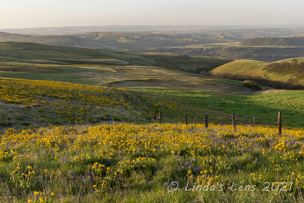
Morning light on the fields


I was planning on photographing the rusty car at sunrise, but since that spot was already taken, I instead headed east of the ranch buildings and set up along an old fence line.  The flower fields were as colorful as I remembered - thick with yellow balsamroot and purple lupine.  Such outstanding beauty!  Now to wait for the sun....


These old fences made great photo subjects

Although the sunrise wasn't spectacular (not much for sky colors) I did enjoy trying to capture several images of rays as the sun rose over the surrounding hills.  And I even got creative (for me) and captured the morning sun streaming behind a fence post.


One more favorite fence photo

Since this entire area had been a ranch for many years, much of the old fence lines were still intact.  As soft morning light spread over the wildflower fields, I enjoyed making images of the lovely yellows, greens and purples of the fields with the fences as my main subject.  What can I say?  I love old fences!


Nothing but wildflowers!

Looking back towards the one of the ranch barns, it was yellow as far as the eye could see.


Purple and gold

This view towards the river was one of my favorites.  I loved the lupine, front and center, followed by a huge explosion of balsamroot, bookended by green pastures and rolling hills.  (I liked this image so much it made it on my Instagram feed)


Backlit wildflower field

An image I only recently edited, this has also become a favorite.  I loved the warm glow of backlit balsamroot and soft background of green bluffs above the Columbia River.


Field damage around the old car

After a nice long photography session in the flower meadows, I contemplated whether to visit the famous old car.  There were still a couple of people down there, but since it had been two years I couldn't resist grabbing a few shots anyway.  So I parked nearby and walked down the fenceline to the field that had become the car's final resting place.


Balsamroot buddies

I was disappointed in what I saw.  In 2014 when I first visited the old car, flowers and grasses had bloomed in abundance around it's frame (see this post from 2017 for comparison).  But since being discovered on social media this old car had been mobbed by the masses.  Now wide dirt paths were stomped around it's perimeter, killing the plants and flowers that used to bloom.  It was sad to see this wonderful place getting degraded.  


Some of the best wildflower displays were near the old car

Yes, I know bloggers like me posting about the Dalles Mountain Ranch on social media have contributed to the problem.  My plea to all those who are reading is this - please be respectful of the environment.  Stay on established paths and avoid stepping on the plants and flowers.  So we can continue enjoying the wonderful wildflower bloom every year, let's work at keeping this place as pristine as humanly possible.


An especially nice lupine patch

Although three photographers were spread out around the old auto, I surreptitiously worked around them and captured a few shots for posterity.  Then, seeing that the wildflower bloom was especially thick in the downhill field, gravitated that direction.


Backlit lupine blooms

The lupine was especially lush along the fence line and I had a great time composing many images.  About ten minutes later, I looked towards the old auto and was surprised to see that all the photographers had left.  


Through the "eyes" of the old car

Hurrying back to the auto I was now free to roam anywhere, capturing images without worry of being in someone else's shot.  And a bonus - the light was fantastic.  It's been my experience that the light on this car and field is much better around 8-9 am than it is at sunrise.


Classic auto image

I spent a happy half hour having a private photo session with the famous Dalles Mountain Ranch rusting automobile.  Unheard of in prime wildflower bloom season!


Lupine at the fence post

But all good things eventually come to and end, and when I noticed people uphill along the fence line walking towards the old car I took it as my cue to move on.


View from the Vista Loop Trail

It was now time for part two of my day at the Dalles Mountain Ranch - hiking the trails that link Highway 14 to the ranch buildings and flower fields.  I drove my car to the Crawford Oaks trailhead and headed uphill along an abandoned road to intersect with the Vista Loop.  I'd hiked these trails last year in early March, right before the virus shut things down (see post here.)  At the time, I'd planned on returning in a month to explore the trails during wildflower season.  Little did I know it would be a full year before I'd actually execute that plan.


Hills yellow with wildflowers (see the car in the middle of this photo?)

The views atop the Vista Loop were stunning.  Not only dotted with fields of colorful wildflowers it also boasted terrific views of Mt Hood and the Columbia River.  Wandering uphill towards the ranch, I feasted my eyes on the nearby rolling hills streaked yellow with patches of balsamroot.


Columbia River view from the ranch

The Vista Loop connected with a trail called the "Ranch Route" that wandered through the Dalles Mountain Ranch area.  The flower patches along this section were sensational.  Soon I was rambling through the same fenceline and fields I'd stood beside for sunrise, several hours ago.


Views from the Eightmile Creek Trail


Below the ranch buildings, the Ranch Route intersected with another trail, this one dubbed the "Eightmile Creek Trail."  This path led downhill, away from the ranch and once again towards the Columbia River and Highway 14 trailhead.


Creek crossing

More fantastic flower fields awaited.  One draw just past a creek crossing was especially lush with dark purple lupine.  So wonderful!  Although only a mile and a half in length, it took well over an hour to cover this distance (too many photo breaks!)

However, at the next trail junction I began to tire.  Well past noon and having been going since sunrise, I was finally getting "flowered out."  Memory card now full of images it was time to stow my camera away, put the hammer down, and march on back to the car.


An especially lush draw

A most productive day!  Wildflowers always make me smile, and I drove home with a permanent grin plastered across my face.  After a turbulent year, it was wonderful to finally be back in my happy place - the colorful balsamroot fields of the eastern Columbia River Gorge.

(And there's more balsamroot posts to come!  Let's just say that this spring I more than made up for missing the 2020 Gorge wildflower season......)

Saturday, May 22, 2021

Swale Canyon

One of my 2021 hiking goals is that 25% of my hikes must be on "new to me" trails.  Having avidly hiked much of NW Oregon and SW Washington over the past 20 years, it gets tougher and tougher to find trails I haven't trod.  This search for new hikes often takes to me far-flung places.  Such as Washington state's Klickitat Rail Trail.


First bridge at trailhead in morning light

The quest to conquer new territory was what brought me to this desolate corner of south central Washington one blustery late March morning.  My day's destination was a portion of the Klickitat Rail Trail, an old railroad line that's now a linear state park.  This 31-mile former rail corridor once linking the towns of Lyle and Goldendale had been converted into a non-motorized multiple use trail.  Starting at Lyle, the trail followed the wild and scenic Klickitat River through the towns of Klickitat and Wahkiacus.  It then turned direction, following Swale Creek through remote Swale Canyon, before ending in the open ranch country of the Goldendale Plateau.  I'd heard the section of trail passing through Swale Canyon was the most spectacular, so it rose to the top of my list.


Blue pond near trailhead

The Swale Canyon portion of the trail was 12.4 miles total one way.  Of course, I wasn't about to hike over 24 miles out and back in one day, so I chose to start at the easternmost limits and hike 6 miles west and north through the canyon to the halfway point, and then return the way I came.  Rumor had it this was the most dramatic and scenic part, and I'm all about the scenery.


Ranch fences

Stepping out of my car that morning, a strong gust nearly took the door off.  Being east of the mountains I'd expected sunshine and hot temps.  However the wind was bone-chilling cold.  I ended up throwing a down vest under my rain shell, donning a knit beanie - and gloves!  Despite the layers I was still freezing.  Time to get moving and hopefully warm up a bit.


Rocky cliff above Swale Creek

The coolest thing about hiking on this converted railroad grade was traveling over all the old wooden bridges that had been saved and restored.  From the trailhead, I immediately walked across a 140-foot long trestle with wooden planking on top.  The adjacent waterway, Swale Creek, glistened a brilliant blue in the early morning light.  Nearby pastureland displayed the green hues of newly-sprouted spring vegetation.


Second bridge

I could hear several birds happily chirping their morning song.  The most distinctive was the melodious tone of the western meadowlark.  I kept searching the grasslands for a glimpse of this beautiful yellow-streaked bird, but they were too good at hiding.  The only meadowlark sighting of the day came 5 minutes into my hike when a pair flew right past me, so close I recognized their distinctive yellow markings.


Third bridge (this one was fantastic!)

Private land bordered both sides of the rail corridor, and I noticed fencing across both banks.  It appeared the land was being used for cattle grazing, but I never saw any livestock.  Swale creek paralleled the path, crossing every so often to one side or the other.  These crossings usually occurred at one of the old rail bridges along the route.  As a matter of fact, I marked progress by my arrival at each of the five railroad bridges between the trailhead and my designated turnaround point.


Desert parsley on rock outcrop 


The second bridge wasn't much, only about 15 feet in length, but the third bridge was fantastic - a long, curving wooden structure.  It was here I met the only person I'd see all morning, a older man with a large, heavily-loaded pack, who said he was training for an upcoming backpacking trip.


Descending into the canyon

As I headed deeper into the canyon, the adjacent hills got higher and steeper.  Multiple clumps of bright yellow desert parsley lined the rocky outcrops, adding color to this desolate country.  But I'd heard the desert parsley was a favorite hangout for ticks, and this being prime tick country, I kept my distance and utilized the camera's zoom lens for any close-ups.


Colorful slopes

Past the third bridge it was a long four miles until the next one.  My path wound through the canyon, following Swale Creek.  I began to notice more trees, first scraggly oaks and then evergreens, mostly ponderosa pines.


Rugged country

Besides the constant bird song, the only other wildlife I saw were tons of ground squirrels.  They were everywhere, on the creek banks, diving into the rocks, running through the bushes.  There must've been plenty of food to support so many.


Old railroad sign

One of the fun things about hiking the Klickitat Rail Trail was seeing some of the old railroad signs that had been left.  A little bit of history (sadly sporting multiple bullet holes....)


Spooky, moss-covered trees

I passed through one narrow place where the uphill slope was covered with spooky moss-covered trees.  


Tall hills on both sides of the trail

About 5 miles into the canyon, the hills became taller and the slopes steeper.  I was surprised to see a house high on one hill and then spot a "land for sale" sign on yet another.  The country was so desolate I didn't think anyone would want to live here.


Blue pool of Swale Creek

Swale Creek dwindled down to a stagnant trickle in many places.  I wondered if it had any flow at all in the summer months.  Out here in the rainshadow of the Cascade mountain range, I'd heard summers were hot and brutal.  As a matter of fact, the conservancy that operates the Klickitat Rail Trail closes it during the summer fire season.  (It would be way too hot to hike in this open country anyway)


More hillside scenery

Finally after a long trek I came upon the fourth bridge.  And, oh what a bridge it was!  Another long, curving trestle, this bridge had open spaces between the transverse ties.  To keep hikers from falling through, two wide boards had been installed in the center ensuring safe passage of all users.


Fourth (and coolest) bridge

Although it was only a quarter mile to the fifth bridge, mile 6 and my designated turn-around point, it seemed to take forever to reach.  When it's short span finally came into view I was a happy hiker.


Fifth Bridge (and turnaround spot)

Wishing to avoid ticks, I chose to sit and have lunch atop a rockpile overlooking Swale Creek instead of in the grass.  As I was eating the second person I'd seen all day came along, a man and his dog who'd hiked from the opposite end of Swale Creek planning to turn around at the same place as I.  We exchanged notes on what we'd seen and when the man asked if there was anything of interest further east, I told him to check out bridge #4 just 1/4 mile away.


Fourth Bridge on return trip

After lunch, it was time to bid bridge #5 goodbye and retrace my steps back to the trailhead.  Bridge #4 seemed to come much sooner than before, and it was such a cool bridge, I spent some time here taking a few more photographs - plus a selfie or two.  I tried to envision what it must've been like for the passengers riding the train through this canyon back in the day.  Was the land as wild and unspoiled as it is now?


Selfie opportunity

After having the trail nearly to myself all morning, on my return trip I began to meet other hikers.  First a couple of small groups, but soon I was seeing a few more hikers and lots of mountain bikers.


White-coated rocks line Swale Creek


I passed an interesting area of Swale Creek where rocks lining the channel were coated in white.  I assume this coating must've been due some type of mineral leaching from the rocks, but I didn't see anything in my online research so I'm not really sure.  But it did make for some cool images.


Columbia desert parsley


Although most of the desert parsley I saw along the trail was yellow in color, I spotted a few clumps of the rarer Columbia desert parsley.  I was told this species is only found in the eastern Columbia River Gorge.  I loved the unique purple color of it's blooms.


Sagebrush lines the trail


Due to the cold winds, I'd kept myself bundled up all morning and didn't shed any layers until reaching my lunch spot.  Deeper into the canyon, the surrounding hills seemed to help buffer the gales and on my return trip I finally felt a bit of warmth.  


Second bridge once again


As a matter of fact, as I trudged back the slightly uphill grade it got downright toasty.  Gazing up at one of the higher cliff faces I watched a trio of vultures circling above, riding the thermals.  As hot and tired as I was feeling, I began to hope they weren't eyeing me.  Good incentive to hasten my pace and look alive!


Yellow-dotted cliffs


Finally bridge #3 came into view.  Then after a bit more uphill I crossed tiny bridge #2.  Yeah - not much farther!


This sign has seen better days


I was passing by a tiny blue pond when I noticed some purple color in the grassy banks.  Grass widow flowers!  I thought the bloom had passed but out here these spring wildflowers were still going strong.  Although up until now I'd avoided grassy slopes due to ticks, I couldn't resist leaving the trail to get a few photographs.


Late blooming grass widows


Making my way down to the riverbank to see the grass widows, I passed a writhing ball of garter snakes wedged between a couple of rocks.  It was such an interesting sight after I'd photographed the grass widows, I returned to snap a few images of the snakes.  Not sure what they were doing.  Since this is a G-rated blog I'm not going to speculate.  (They were huddled together for warmth - lol!)


Pile of snakes!


As I crested the final rise past another blue pool of Swale Creek, I could see the first railroad bridge far ahead and beyond that the road with quite a few more cars parked along it.  Almost done!  And after 12 miles my feet were telling me it was time for a break.


Vibrant vegetation lining Swale Creek


But not before one final wildlife sighting.  Passing by a wide spot in the creek I spotted a pair of yellowlegs on the opposite side.  Hoping to photograph some birds, I'd carried a zoom lens in my backpack the entire trip.  Now I fished it out and used it to get a few dozen shots of these unique shorebirds.


Yellowlegs


It was fun to explore a new trail in different environment.  I enjoyed following the old rail grade as it wound through remote Swale Canyon.  One of the benefits of challenging myself to hike new trails, it forces me to discover places I ordinarily wouldn't think to visit.