One of my 2021 hiking goals is that 25% of my hikes must be on "new to me" trails. Having avidly hiked much of NW Oregon and SW Washington over the past 20 years, it gets tougher and tougher to find trails I haven't trod. This search for new hikes often takes to me far-flung places. Such as Washington state's Klickitat Rail Trail.
 |
| First bridge at trailhead in morning light |
The quest to conquer new territory was what brought me to this desolate corner of south central Washington one blustery late March morning. My day's destination was a portion of the Klickitat Rail Trail, an old railroad line that's now a linear state park. This 31-mile former rail corridor once linking the towns of Lyle and Goldendale had been converted into a non-motorized multiple use trail. Starting at Lyle, the trail followed the wild and scenic Klickitat River through the towns of Klickitat and Wahkiacus. It then turned direction, following Swale Creek through remote Swale Canyon, before ending in the open ranch country of the Goldendale Plateau. I'd heard the section of trail passing through Swale Canyon was the most spectacular, so it rose to the top of my list.
 |
| Blue pond near trailhead |
The Swale Canyon portion of the trail was 12.4 miles total one way. Of course, I wasn't about to hike over 24 miles out and back in one day, so I chose to start at the easternmost limits and hike 6 miles west and north through the canyon to the halfway point, and then return the way I came. Rumor had it this was the most dramatic and scenic part, and I'm all about the scenery.
 |
| Ranch fences |
Stepping out of my car that morning, a strong gust nearly took the door off. Being east of the mountains I'd expected sunshine and hot temps. However the wind was bone-chilling cold. I ended up throwing a down vest under my rain shell, donning a knit beanie - and gloves! Despite the layers I was still freezing. Time to get moving and hopefully warm up a bit.
 |
| Rocky cliff above Swale Creek |
The coolest thing about hiking on this converted railroad grade was traveling over all the old wooden bridges that had been saved and restored. From the trailhead, I immediately walked across a 140-foot long trestle with wooden planking on top. The adjacent waterway, Swale Creek, glistened a brilliant blue in the early morning light. Nearby pastureland displayed the green hues of newly-sprouted spring vegetation.
 |
| Second bridge |
I could hear several birds happily chirping their morning song. The most distinctive was the melodious tone of the western meadowlark. I kept searching the grasslands for a glimpse of this beautiful yellow-streaked bird, but they were too good at hiding. The only meadowlark sighting of the day came 5 minutes into my hike when a pair flew right past me, so close I recognized their distinctive yellow markings.
 |
| Third bridge (this one was fantastic!) |
Private land bordered both sides of the rail corridor, and I noticed fencing across both banks. It appeared the land was being used for cattle grazing, but I never saw any livestock. Swale creek paralleled the path, crossing every so often to one side or the other. These crossings usually occurred at one of the old rail bridges along the route. As a matter of fact, I marked progress by my arrival at each of the five railroad bridges between the trailhead and my designated turnaround point.
 |
| Desert parsley on rock outcrop |
The second bridge wasn't much, only about 15 feet in length, but the third bridge was fantastic - a long, curving wooden structure. It was here I met the only person I'd see all morning, a older man with a large, heavily-loaded pack, who said he was training for an upcoming backpacking trip.
 |
| Descending into the canyon |
As I headed deeper into the canyon, the adjacent hills got higher and steeper. Multiple clumps of bright yellow desert parsley lined the rocky outcrops, adding color to this desolate country. But I'd heard the desert parsley was a favorite hangout for ticks, and this being prime tick country, I kept my distance and utilized the camera's zoom lens for any close-ups.
 |
| Colorful slopes |
Past the third bridge it was a long four miles until the next one. My path wound through the canyon, following Swale Creek. I began to notice more trees, first scraggly oaks and then evergreens, mostly ponderosa pines.
 |
| Rugged country |
Besides the constant bird song, the only other wildlife I saw were tons of ground squirrels. They were everywhere, on the creek banks, diving into the rocks, running through the bushes. There must've been plenty of food to support so many.
 |
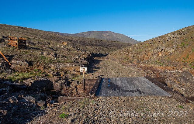
| Old railroad sign |
One of the fun things about hiking the Klickitat Rail Trail was seeing some of the old railroad signs that had been left. A little bit of history (sadly sporting multiple bullet holes....)
 |
| Spooky, moss-covered trees |
I passed through one narrow place where the uphill slope was covered with spooky moss-covered trees.
 |
| Tall hills on both sides of the trail |
About 5 miles into the canyon, the hills became taller and the slopes steeper. I was surprised to see a house high on one hill and then spot a "land for sale" sign on yet another. The country was so desolate I didn't think anyone would want to live here.
 |
| Blue pool of Swale Creek |
Swale Creek dwindled down to a stagnant trickle in many places. I wondered if it had any flow at all in the summer months. Out here in the rainshadow of the Cascade mountain range, I'd heard summers were hot and brutal. As a matter of fact, the conservancy that operates the Klickitat Rail Trail closes it during the summer fire season. (It would be way too hot to hike in this open country anyway)
 |
| More hillside scenery |
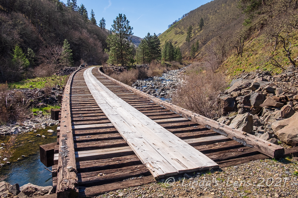
Finally after a long trek I came upon the fourth bridge. And, oh what a bridge it was! Another long, curving trestle, this bridge had open spaces between the transverse ties. To keep hikers from falling through, two wide boards had been installed in the center ensuring safe passage of all users.
 |
| Fourth (and coolest) bridge |
Although it was only a quarter mile to the fifth bridge, mile 6 and my designated turn-around point, it seemed to take forever to reach. When it's short span finally came into view I was a happy hiker.
 |
| Fifth Bridge (and turnaround spot) |
Wishing to avoid ticks, I chose to sit and have lunch atop a rockpile overlooking Swale Creek instead of in the grass. As I was eating the second person I'd seen all day came along, a man and his dog who'd hiked from the opposite end of Swale Creek planning to turn around at the same place as I. We exchanged notes on what we'd seen and when the man asked if there was anything of interest further east, I told him to check out bridge #4 just 1/4 mile away.
 |
| Fourth Bridge on return trip |
After lunch, it was time to bid bridge #5 goodbye and retrace my steps back to the trailhead. Bridge #4 seemed to come much sooner than before, and it was such a cool bridge, I spent some time here taking a few more photographs - plus a selfie or two. I tried to envision what it must've been like for the passengers riding the train through this canyon back in the day. Was the land as wild and unspoiled as it is now?
 |
| Selfie opportunity |
After having the trail nearly to myself all morning, on my return trip I began to meet other hikers. First a couple of small groups, but soon I was seeing a few more hikers and lots of mountain bikers.
 |
| White-coated rocks line Swale Creek |
I passed an interesting area of Swale Creek where rocks lining the channel were coated in white. I assume this coating must've been due some type of mineral leaching from the rocks, but I didn't see anything in my online research so I'm not really sure. But it did make for some cool images.
 |
| Columbia desert parsley |
Although most of the desert parsley I saw along the trail was yellow in color, I spotted a few clumps of the rarer Columbia desert parsley. I was told this species is only found in the eastern Columbia River Gorge. I loved the unique purple color of it's blooms.
 |
| Sagebrush lines the trail |
Due to the cold winds, I'd kept myself bundled up all morning and didn't shed any layers until reaching my lunch spot. Deeper into the canyon, the surrounding hills seemed to help buffer the gales and on my return trip I finally felt a bit of warmth.
 |
| Second bridge once again |
As a matter of fact, as I trudged back the slightly uphill grade it got downright toasty. Gazing up at one of the higher cliff faces I watched a trio of vultures circling above, riding the thermals. As hot and tired as I was feeling, I began to hope they weren't eyeing me. Good incentive to hasten my pace and look alive!
 |
| Yellow-dotted cliffs |
Finally bridge #3 came into view. Then after a bit more uphill I crossed tiny bridge #2. Yeah - not much farther!
 |
| This sign has seen better days |
I was passing by a tiny blue pond when I noticed some purple color in the grassy banks. Grass widow flowers! I thought the bloom had passed but out here these spring wildflowers were still going strong. Although up until now I'd avoided grassy slopes due to ticks, I couldn't resist leaving the trail to get a few photographs.
 |
| Late blooming grass widows |
Making my way down to the riverbank to see the grass widows, I passed a writhing ball of garter snakes wedged between a couple of rocks. It was such an interesting sight after I'd photographed the grass widows, I returned to snap a few images of the snakes. Not sure what they were doing. Since this is a G-rated blog I'm not going to speculate. (They were huddled together for warmth - lol!)
 |
| Pile of snakes! |
As I crested the final rise past another blue pool of Swale Creek, I could see the first railroad bridge far ahead and beyond that the road with quite a few more cars parked along it. Almost done! And after 12 miles my feet were telling me it was time for a break.
 |
| Vibrant vegetation lining Swale Creek |
But not before one final wildlife sighting. Passing by a wide spot in the creek I spotted a pair of yellowlegs on the opposite side. Hoping to photograph some birds, I'd carried a zoom lens in my backpack the entire trip. Now I fished it out and used it to get a few dozen shots of these unique shorebirds.
 |
| Yellowlegs |
It was fun to explore a new trail in different environment. I enjoyed following the old rail grade as it wound through remote Swale Canyon. One of the benefits of challenging myself to hike new trails, it forces me to discover places I ordinarily wouldn't think to visit.


"Klickitat" - it even sounds like a train crossing a trestle.
ReplyDeleteQuite a contrast to the usual mountain country featured in your hikes. It must've been a tough job building a railway through country like that.
Hello Linda,
ReplyDeleteIt is great you are hiking new trails and discovering new places. The views along the rail trail are pretty, great sighting of the Yellowlegs. That looks like a lots of snakes curled up together, ugh. The wildflowers are beautiful. Great report and photos. Happy Sunday, wishing you a great new week!
...a different landscape than I'm used to seeing, but people seem to shot at signs everywhere.
ReplyDeleteHmm 25%? You could come here and get all of that in one week!
ReplyDeleteStunning area! And it looks so peaceful.
ReplyDeleteThat looks like a great place to run.
ReplyDeleteI love the trail, but am not impressed with the snakes! Are they poisonous?
ReplyDeleteI would enjoy walking over those bridges! Not so much seeing the snakes.
ReplyDelete