Remember in a previous post how I'd hiked up Ape Canyon, under Mt St Helens' summit, walked across the Plains of Abraham and got views of a lovely flower-filled butte, but it was just a bit too far for a day hike? Well a few weeks later, I went back and hiked to this area via a different trail from the north. That hike is what this post is all about. (Be prepared for lots of photos!)
 |
Morning light on Mt St Helens
|
I love hiking from the Windy Ridge (northeast) side of Mt St Helens. However, reaching this trailhead requires a 3-hour (one way) drive from Portland, the last hour over windy Forest Service roads in poor condition. But my desire to see the flower fields before the wildflowers wilted away was further fueled by photos from a friend that had hiked the same area, and not only did she see loads of flowers, she also encountered mountain goats!
 |
Our first leg was on an old road
|
Luckily my hubby decided to accompany me on this latest hiking adventure, so I had company for the long drive. We left early one mid-July morning and the drive was fairly uneventful except for when I hit a hidden pothole going a bit too fast (oops!). Hubby got excited and made me pull over so he could check my car's underside to make sure I didn't punch a hole in anything. (Spoiler - my car was fine, but boy did I drive like a granny after that!)
 |
Loved the wispy clouds above MSH
|
Finally after a looonnng journey, we arrived at the Windy Ridge Trailhead parking area. Naturally after being in the car for three hours, the first thing I did was sprint for the bathroom, only to be foiled by a filthy restroom completely out of toilet paper. Good thing I keep a surplus of Starbucks napkins in my car!
 |
Loowit Trail junction
|
After taking care of restroom needs, putting on hiking boots and resetting my gps I was ready to go. Hubby and located the start of our trek - an abandoned road. We'd follow this road for nearly two miles before joining the Loowit Trail proper.
 |
Spirit Lake and a bazillion paintbrush flowers
|
The weather was perfect - blue skies and pleasant temperatures. The road gave fantastic views of MSH's truncated north side. You could see right into the crater, and I spotted the lava dome that's been building inside since the 1980 eruption. From this angle the mountain kind of looked like a large melted cake.
 |
Looking into the crater - notice the lava dome in the center
|
Not only were the mountain views immediate so was the wildflower show. Flowers lined the sides of the abandoned road, and my camera was out well before the half mile mark.
 |
Rockfall from the west crater wall
|
After a long nearly 2 miles the road ended at the junction of the Loowit and Abraham Trails. The Loowit is the trail that circles the entire perimeter of Mt St Helens. Having hiked this route several years ago I opted to first follow the Loowit Trail towards the volcano's crater. So off hubby and I went, past a huge field of orange Indian paintbrush. As we progressed along the Loowit, views of Spirit Lake began to show over the horizon.
 |
Dramatic views crossing a dry creek
|
The views into the volcano crater were amazing! The closer we got the more the landscape changed. The west crater wall still had a small amount of snow on top, but it appeared to be rapidly melting in the rising temperatures. We even witnessed a large rockslide off the west crater wall.
 |
Loowit falls from a distance
|
After nearly 2.5 miles of walking through this desolate but interesting plain we got a glimpse of our goal ahead - Loowit Falls. This waterfall was created from melting snow in MSH's crater and flows towards Spirit Lake. A side trail took us from the Loowit towards this cascade. This trail's terminus at Loowit Falls is the closest hikers are allowed to get to the crater itself.
 |
Mountain goats!
|
As hubby and I approached the waterfall, we noticed a few white dots moving on the rocky slope above us. Mountain goats! Quickly I switched to my zoom lens and attempted to capture a bunch of images. Unfortunately the goats were quite a distance away, and a 200 mm zoom lens didn't quite cut it. But the goats were still fun to watch. A father, mother and baby goat slowly made their way to the shade of a large rock, where they finally bedded down.
 |
| We watched the goats for quite some time |
I could've watched the goats all day, but we had a waterfall to see and many more miles to cover. So hubby and I continued along the trail until we reached the designated overlook for Loowit Falls. We took a quick snack break, and I snapped a few photos. Then, refreshed, we retracted our steps back along the Loowit trail.
 |
Loowit Falls at our turn-around point
|
The second part of our loop necessitated a return on the same portion of the Loowit Trail we'd just covered. After a mile and a half, however, we turned and headed towards Windy Pass.
 |
Heading to Windy Pass
|
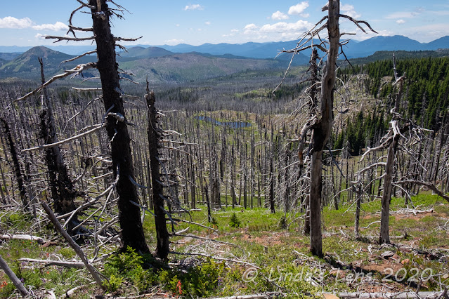
The landscape was stark. Although some small bushes were beginning to grow, there were no large trees to provide shade. Luckily it wasn't too hot quite yet, but I could feel the temperatures rising and switched to my floppy-brimmed hat and sunglasses.
 |
One last look at Spirit Lake
|
As we began climbing towards Windy Pass, I took one last look at Spirit Lake, spread out below. Mt Rainier's snowy summit peeped over the top of the surrounding hills.
 |
Quick break on Windy Pass
|
The climb up Windy Pass was sketchy. The trail snaked up the side of a steep slope, often only the width of our two feet. The slope dropped off precariously below us and as we climbed, the elevation difference became higher and higher. A couple of places, I pasted myself against the rocky cliff on the uphill side just to ensure I didn't slide down the slope below. Hubby and I came upon an older couple standing in the trail. The wife was freaked out by the steep slopes and exposure below the trail and, paralyzed by fear, was unable to move. We somehow shuffled by the couple, and I recommended they descend and try another trail. (I think that's what they finally did)
 |
Fantastic Mt Adams view on the other side of Windy Pass
|
Finally after lots of huffing and puffing we reached the top of Windy Pass. And boy the views were fabulous! We could see Mt Adams and Hood from one direction, and Spirit Lake and Mt Rainier from the other. And of course MSH's summit was front and center. Famished from the climb, we took a break to eat our sandwiches.
 |
Looking back towards Windy Pass
|
From my previous hike here several years ago, I remembered the descent down the other side of Windy Pass as a sketchy, treacherous slide down a sandy, rocky slope. So I was a wee bit apprehensive about the route down. But as it turned out, my fears were for naught. Since my last visit, some trail maintenance had been performed and the trek back down was drama-free. And as a bonus, there was an amazing view of Mt Adams as we descended.
 |
Stepping aside for trail runners
|
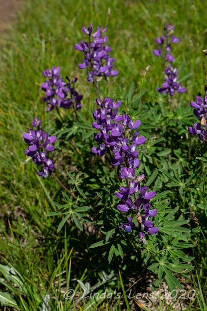
At the bottom of the slope was the Plains of Abraham, a barren rock-strewn desert created from the eruption. But this area boasted some of the best wildflower fields. Lupine covered the plains, creating some lovely photo ops. At this point, we encountered a large group of trail runners, trying to cover the entire 32-mile Loowit Trail in one day. I couldn't even imagine running that far!
 |
Lupine was thick here!
|
From here the Loowit wandered across the Plains of Abraham, through lupine fields and stellar views of MSH. After another mile this path intersected with the Abraham Trail, which coincidentally was the turn-around point of my Ape Canyon hike several weeks ago.
 |
Heading across the Plains of Abraham
|
But instead of taking the Loowit towards Ape Canyon, today hubby and I were hiking on the Abraham Trail towards those fantastic flower fields. We crossed a gully and climbed the other side, and came upon the best wildflower display we'd seen yet.
 |
Wildflowers in every gully
|
Orange Indian paintbrush filled the slopes. It was everywhere! Any forward progress I had made stopped right there.
 |
Then we entered the paintbrush zone
|
The next two miles on the Abraham Trail were a wildflower photographer's dream.
 |
Fields of orange Indian paintbrush everywhere!
|
Huge fields of Indian paintbrush climbed slopes, filled gullies and lined ridges. And to add icing on the cake, Mt Adams and Mt Rainier peeked over the horizon.
 |
A very colorful gully
|
Not only paintbrush, many gullies were filled with pink and yellow monkeyflowers.
 |
Orange hillside
|
My poor hubby had to do a lot of waiting! I wasn't exactly the speediest hiker.
 |
| Flowers and Mt Adams |
|
But with scenery like this how could anyone hurry through it?
 |
Colorful trail
|
The Abraham trail wound through several drainages before finally topping out and following a ridgeline.
 |
Then came the yellow zone
|
From this vantage you could see our trail all the way back to the old road - the very one we'd hiked at the beginning of the day.
 |
Our trail snakes across the ridgetop
|
As the trail grew closer to this road, the wildflowers changed from paintbrush to yellow Oregon Sunshine. It was equally as stunning.
 |
Looking back at MSH
|
The concentration of wildflowers along the Abraham trail was simply incredible. And lucky for me, I'd caught it near the peak bloom.
 |
We had to navigate a series of steep log stairs
|
Towards the end of the Abraham Trail, the slope got so steep the trail builders had installed a few sets of log stairs. I think they were intended to keep hikers from sliding down the sandy slope, but they were difficult to navigate.
 |
Looking towards our path back to the car
|
But hubby and I managed to get down the endless sets of log stairs. At one of the flat spots, hubby spotted a toad resting in the rocky soil. Our second wildlife sighting of the day! With no water nearby, it seemed like an unusual place for a toad to live.
 |
Surprised to see a toad in this dry environment
|
Although I enjoyed the trek along the Abraham trail immensely, I was happy to see the junction with the old road again. By now the day was warm and I was hot and tired and ready to be back at our car.
 |
More flower-filled slopes
|
It's no fun to end a hike with an uphill road walk. But that was the price of admission to this amazing area, so hubby and I put our heads down and one foot in front of the other. Luckily there were more great views of Mt Adams to keep our eyes occupied.
 |
Final leg back on the road
|
A path that wandered close to the MSH crater, a secret waterfall inside, mountain goats, climbing over a pass with fantastic views, flower fields below, and an amazing wildflower-lined trail. This hike had it all! Another great day exploring one of my favorite places.


