Tuesday, October 29, 2019

Return to Rainier

Ever since last year's amazing trip to the Paradise side of Mt Rainier National Park, I'd been plotting a return.  My glowing descriptions of trails and photographs must've sparked my hiking buddy Young's interest because this summer she asked to come with me.


Myrtle Falls

More than happy to show my friend this wonderful place, we left Portland in the wee hours one early August morning.  After securing a coveted walk-up spot at the Cougar Rock Campground, Young and I grabbed our backpacks and headed for the Paradise Visitor Center to hike one of my favorite trails in the park - the jaw-dropping Skyline Loop.


Money shot!

This six-mile circuit above the Paradise Lodge packs a lot of scenery into a short distance. Wildflowers fill the forested slopes, especially in early August.  At the trail's high points, mountain views extend from every direction.  Wildlife sightings are common - marmots, pikas, chipmunks, deer, and a large variety of birds.  I'd even heard reports of a black bear frequenting the area.

After hiking the loop last year, (see recap here) I knew it was destined to become an annual tradition. 


Magenta paintbrush and "hippies"

It was midday by the time Young and I arrived at Paradise.  However, being a Thursday I was still able to score a parking spot in the main lot.  And the mountain was out - towering above the visitor center, glaciers gleaming white.  Clear skies highlighted Mt Rainier in her full glory.  After snapping some obligatory photos at the granite steps framing this mountain view, Young and I headed down the paved path towards Myrtle Falls.


Lupine gets in on the action

The wildflower show started immediately.  With both of us toting cameras, progress was glacially slow.  But we finally made it the half mile to Myrtle Falls, and despite shadows, attempted to capture the iconic shot of this cascade with Mt Rainier anchoring the background.


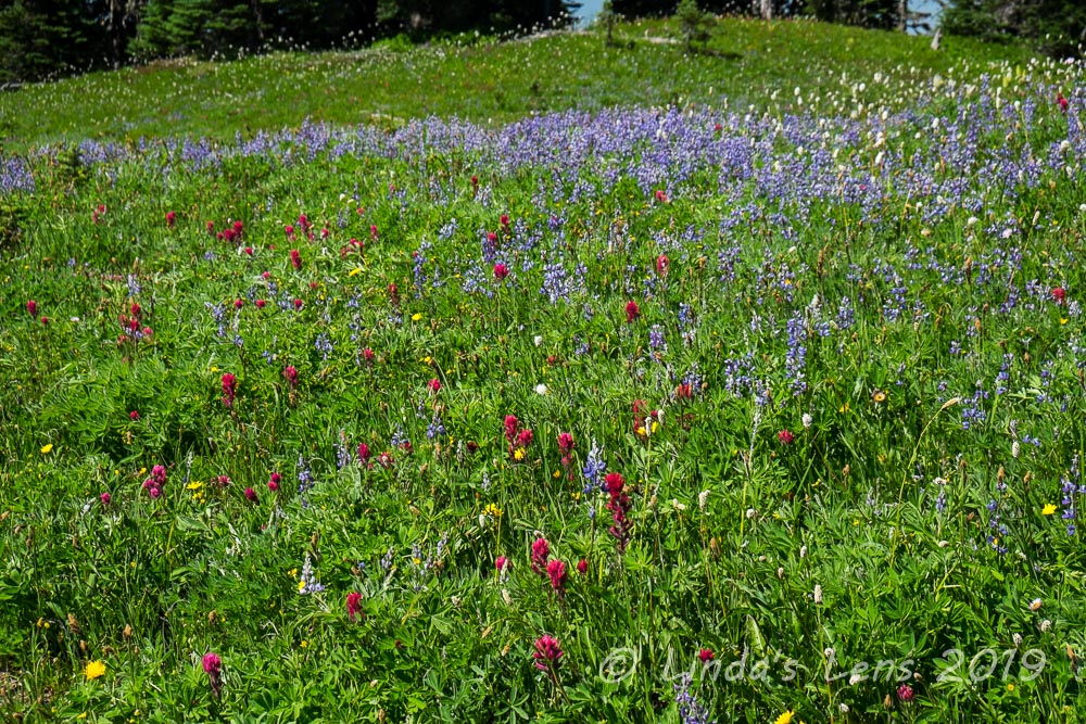
Flower-dotted slopes

We then followed the trail as it wound through more technicolor meadows.  Magenta paintbrush dotted nearby slopes, sometimes accented with purple lupine and fluffy-topped Western pasqueflower (or as I call it "hippy on a stick").


Young taking it all in

We passed an outstanding view of Mt Rainier with a slope full of magenta paintbrush in the foreground.  It was such a perfect photo op!  Young and I spent many minutes capturing the scene from all angles.  I got several money shots - one of these will definitely grace a page of my yearly calendar.


Asters

Temps were rising, and it was a hot climb above treeline, past a wide glacial stream with stunning reflections of Mt Rainier in its waters.


Mountain reflections
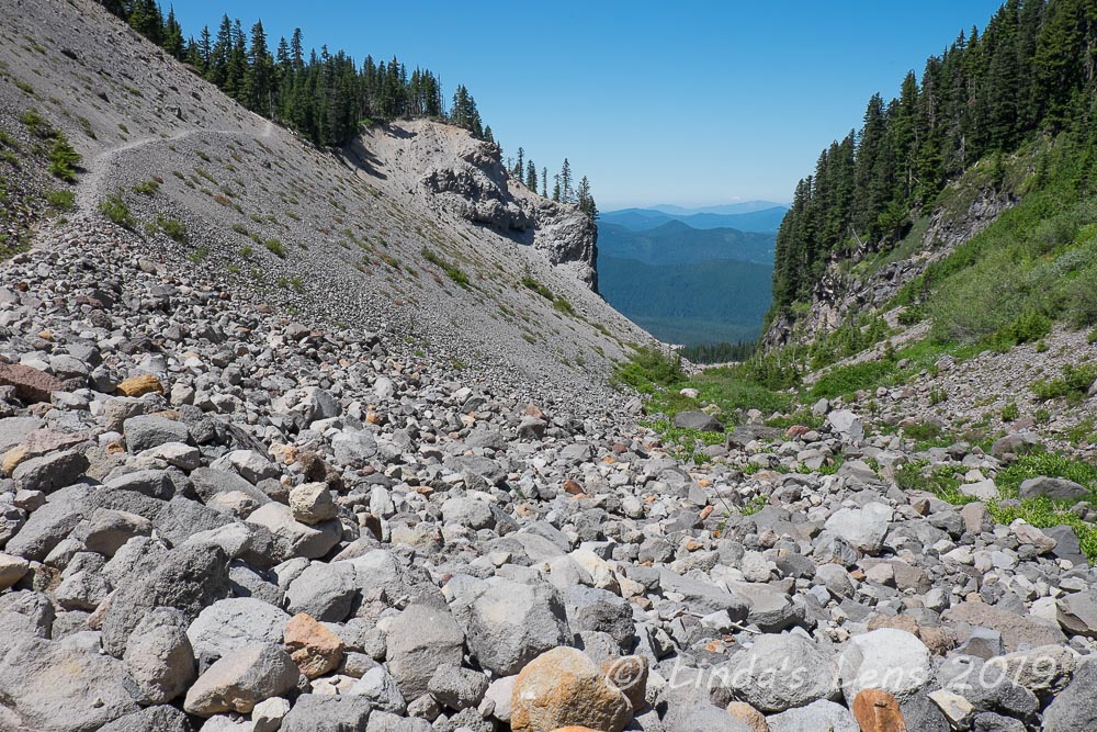
After a quick lunch break, Young and I continued our climb high above treeline.  Views of the adjacent mountains opened up below us, as well as Mt Rainer front and center, getting closer the higher we ascended.


Stairway to the top

We began to see patches of snow in lower gullies.  On one slope, a few people were happily sliding downhill on their behinds.  In another larger tract, a mountain climbing class was practicing roping up and self arresting with ice axes.


Still some snow patches hanging around

For such a short trail, climbing to the highest point seemed to take forever.  It's 3 miles to the Mt Rainier overlook, but 1700 feet up.  Rocky trails made for slow going. 


Will the climbing ever end?

But finally Young and I arrived at the trail's highest point.  Our reward - a magnificent in-your-face view of Mt Rainier.  The mountain absolutely filled the skyline.  It was as if you could reach out and touch its glaciated slopes.  Copious photo-taking ensued.  One nice lady even took a few photos of my friend and I celebrating our accomplishment.  (Oh - and we didn't plan to wear the same color clothing, it just happened!)


Grand Rainier view at the trail's high point

Taking a break to soak in the views, Young and I also entertained ourselves people watching.  This high point seemed to be a popular stopping area, and there were several groups scattered about.  Lots of different languages spoken, and all varieties of clothing choices, from traditional hiking garb to flip flops.  Lots of cell phone cameras recording the moment - even a few selfie stick sightings!  We spotted many mountaineering groups, loaded down with huge backpacks, heading up the glacier to Camp Muir.


Heading back down

Our climbing now done for the day, it was time to head downhill to Panorama Point.  But first Young and I heeded the call of nature and visited the trail's high-altitude restroom just below the viewpoint.  While waiting for my friend, I had to shoo a very aggressive ground squirrel away from her backpack.


Panorama Point

Young and I made a quick stop at Panorama Point.  This place was swarming with both people and chipmunks.  The little rodents were apparently well-fed because they weren't at all shy about begging people for snacks.  We spotted one portly ground squirrel with his (her?) belly dragging on the ground.  Not sure if it was a pregnant female or just really fat.


Really fat ground squirrel

I thought we'd already passed by the best flower fields, but couldn't have been more wrong!  As Young and I descended back towards the Paradise Lodge, we passed by huge patches of lovely pink heather.


Lots of pink heather blooming

Framed by adjacent mountains, it was absolutely stunning!


Rainier and heather

Last year this was the portion of the hike where I was nursing an ailing camera battery, so didn't get many photos.  I'm happy to report that this time I more than made up for the deficit!


More lovely heather

Although this trail is always wildly busy, hiking on a weekday (Thursday) the crowds weren't quite as large.  It was kind of nice not having to dodge long conga-lines of people streaming uphill.  Note to self - plan next year's trip for mid-week.


Lots of flowers along the Skyline Trail

Oh yeah, there will definitely be a return trip in my future next summer!  And Young was so impressed, I think I'll have a willing companion. 


Wonderful day!

Our trip back to the lodge was a continuous parade of mountain views and flower-filled slopes.  Taking most of the day to traverse the loop, we didn't arrive back at my car until late afternoon.  But scenery this spectacular was meant to be sauntered through and enjoyed to the fullest.  As my friend and I headed back to our campsite, I was already plotting where I'd take her the following day.

To be continued.......


Tuesday, October 22, 2019

Summer Paradise

Where does one go to satisfy their hiking fix on a hot day in late July?  Why, you head to the mountains!  One of my favorite summer hikes is the trek to Mt Hood's lovely, flower-filled Paradise Park.


Timberline Lodge in the morning light

To beat the heat, summer days dictate early starts.  I arrived at Timberline Lodge soon after sunrise, and enjoyed the cool morning temps while I could.  Morning light illuminated the nearby mountains with Mt Jefferson's white pointy peak prominently rising above the Cascade foothills.


Skier heading up the lift

In good snow years, Timberline runs their ski area nearly year-round, providing groomed slopes on Mt Hood's high glaciers.  As I walked underneath the Magic Mile lift, it was weird to see it running in the summer, and even more unusual to see skiers occupying the chairs.  But instead of being already geared up, these skiers were carrying their skis and boots.  They had to ride a second chairlift to reach the actual snow.


Patchwork snow on Mt Hood

Because warm summer temperatures render snow a slushy mess by noon, summer skiers start early.  Timberline caters to various ski camps throughout the summer season.  I'm told the US ski team even trains here.  Looking up towards Mt Hood, what snow was left appeared mighty patchy.  Hiking seemed like the better option today.


Monkeyflowers

For the first mile I followed the iconic Timberline Trail across ski slopes, admiring purple lupine and yellow wildflowers.  I kept leapfrogging a couple of young folks with large backpacks.  Finally I came upon them standing in the trail.  The couple asked if I had a map they could look at.  Always prepared (I never hike anywhere without a paper map - even if it's a trail I've done many times) I whipped out my Timberline Trail map.  Chatting with the couple I learned they were backpacking the entire Timberline Trail - but lacked any map.  (People that head out on long hiking journeys without the proper navigation tools always amaze me!)  The couple used their phones to photograph my map.  (I sure hope that their batteries were fully charged.)


Gorgeous butterfly

After parting ways with the unprepared hikers, I crossed Little Zigzag Canyon, contoured across another flower-filled gully and came upon the larger Zigzag Canyon.  This deep gorge, impressive when viewed from the very top, drops several hundred vertical feet for a mile before crossing the Zigzag River. 


Oregon Sunshine

Downward I descended, sometimes steeply, through flower-filled slopes.  I captured a couple of butterflies enjoying the blooms and admired a lovely display of pink and yellow monkeyflowers.


Small snow patch to cross

Finally arriving at the canyon's very bottom, I surveyed the Zigzag River's fast-moving glacial waters for a good place to cross.  Myself and another backpacking couple walked up and down the bank trying to locate the perfect crossing, until finally I picked a place that appeared to have enough large well-spaced rocks to hop across.  Stream crossings always look much worse than they really are, and this one was no exception.  I bounded across with no problem and was soon ascending the canyon's opposite side.


Lupine

It was a steep climb out of the canyon, and the day was beginning to heat up.  Soon I came upon a spur trail that branched off the Timberline trail, taking hikers to lovely Paradise Park. 


Mariposa lily (aka "Cats ear")

More sweaty climbing ensued.  But I passed through many fields of lovely wildflowers, so that helped.  One slope was covered with white Mariposa lilies, sometimes referred to as "Cats ears."  Another slope had huge concentrations of lupine and orange Indian paintbrush.  I took many photo (aka rest) breaks to capture the beauty.  I passed a group of young men backpackers, and one guy had a roll of toilet paper affixed to the outside of his pack (I joked that he was well prepared!)


No flowers yet at the grand meadow

There's one trail junction on the Paradise Park loop that is famous for having huge wildflower meadows.  Mt Hood looms over the horizon, making it a special scenic spot.  However, I must have been too early, because when I came upon said junction, absolutely nothing was blooming.  It was kind of a disappointment.  I took a photo of Mt Hood with the sign, and kept going.


Lots of lupine and hippies around the bend

Luckily, not much farther away, I did find a few blooming wildflowers.  Lupine and mop-headed Western Pasqueflowers (aka "hippy on a stick") covered an adjacent slope.  The fluffy "hippy" flowers always make great photo subjects!


Two bees

And I also managed to capture two different kinds of bees on one flower.


"Hippy on a stick"

After a quick lunch break under a grove of scraggly trees, the trail continued above timberline for wide-open views of the surrounding foothills, with Mt Hood anchoring the sky.


Mt Hood sighting in Paradise Park

Magenta Indian Paintbrush blooms occasionally appeared trailside, providing color to an otherwise gray, rocky scene.


Pink heather and expansive views

I even glimpsed a few patches of pink heather standing out amongst the greenery.


Checking out Split Rock

One of Paradise park's local landmarks is a huge isolated boulder, with a wide crack running through the middle.  Nicknamed "Split Rock" by the local hiking community, it's worth a quick climb up a gravelly bootpath to see it.


Magenta paintbrush

I love the views of Mt Hood from Split Rock, so eagerly trekked uphill hoping to spend some quality time hanging out and photographing the area.  However, upon my arrival, I discovered a huge group of older hikers had already arrived, and were spread out around the rock enjoying an extended lunch break. They weren't very friendly - a couple of the men gave me the evil eye when I approached, camera in hand.  Not wanting grumpy people in my photos, I retreated (but not before snapping a self-portrait for my #52hikechallenge blog page!)


Mt Hood rises over the meadow

The Paradise Park loop meandered through more open wildflower meadows, before charging steeply downhill to reconnect with the Timberline Trail.  I passed by several campsites, many already claimed by weekend backpackers. 


Huge patch of avalanche lilies on the Timberline Trail

Connecting once again to the Timberline Trail/Pacific Crest Trail (these trails combine for a few miles here) I headed back towards Zigzag Canyon.  I came upon a shady area that was chock-full of avalanche lilies.  An early-blooming spring flower, I assumed that the shaded spot had something to do with the longevity of this particular patch. 


Timberline trail crossing a drainage channel

After leaving the Paradise Park loop, I'd kind of assumed the good scenery was done for the day, but no, this portion of the Timberline Trail was just as lovely.  I crossed flower-filled drainages, and passed by rocky gullies with peek-a-boo glimpses of the surrounding mountains.  There were even a couple of waterfalls.  I chatted with several groups of backpackers, most attempting to hike the entire 40-mile Timberline Trail loop.  I even met a couple of PCT through-hikers.


Colorful monkeyflowers in Zigzag Canyon

Before I knew it, the trail began descending to the bottom of Zigzag Canyon.  Time to cross that river again!  Although the river was flowing much stronger, due to afternoon snowmelt swelling it's waters, I hopped across the same spot a second time with no problems.


Another beautiful butterfly

Now came the tough part of this hike - climbing out of ZigZag canyon in the afternoon heat.  Not only that, beyond the top of Zigzag Canyon, the final two miles to Timberline Lodge were also uphill. 


Zigzag Canyon

It was a hot, slow, extremely sweaty trudge out of the canyon.  The only good thing was the trail being mostly in shade.  But once I arrived at the top of the mighty Zigzag, it was all sun for the next two miles.


Ski lifts and Mt Jefferson

By now my feet were beginning to complain.  Although thirsty, I rationed my water supply to make sure I had enough to get me to the trailhead.  Good thing there were some lovely views to distract me from my misery.


Not much snow left to ski on

Late afternoon light illuminated Mt Hood beautifully.  Although skiing was done for the day, I had a good view of the tiny rectangle of groomed snow above the Palmer lift.  Sure didn't look big enough to do much skiing.


PCT trail sign near Timberline Lodge

I was never so glad to reach the PCT sign located directly above the road to Timberline Lodge.  That meant I was almost done!  It was a long, hot 14 mile day, but I came away with a camera full of beautiful images and although the body was weary, my mind was refreshed.  Now it was time to refuel with a well-deserved burger and beer!

Hike no. 35 done!  #52hikechallenge


Tuesday, October 15, 2019

Beyond Coldwater

I love hiking the bare plains north of Mt St Helens.  The post-eruption landscape is fascinating.  It's so interesting to witness life returning to the devastated areas around this famous volcano.  Long-time readers know that one of my favorite summer hikes is the trek to Coldwater Peak via the Boundary Trail.


Foggy morning on the Boundary Trail

However, the Boundary Trail continues past Coldwater Peak into the wild, desolate Mt Margaret Backcountry.  Having never ventured beyond the Coldwater Peak turnoff, this year I decided it was time to explore further.  So on a mid-July Friday, I hatched a plan to hike past Coldwater Peak and St Helens Lake to see what was there.  Since it would be a long distance, I arrived early at Johnston Ridge Observatory and was on the trail before 8 am.


Paintbrush was poppin'

Weather at MSH is always unpredictable, and today was no different.  Upon arrival at Johnston Ridge, I found the area enveloped in a thick fog.  As I started out on the Boundary Trail, the clouds would clear momentarily, giving quick glimpses of the adjacent slopes, before swirling back and covering everything.  At least the summer wildflower bloom was still going strong, and the thousands of bright orange Indian Paintbrush gave me something nice to look at.


Best view of Mt St Helens all day

About a mile on the trail and the clouds suddenly parted to reveal a full view of Mt St Helens in all her barren glory.  Out came the camera, and I snapped away.  Little did I know at the time, but that would be the best view I'd have of the mountain for the entire day.


Lots of orange!

The fog quickly returned, and I packed my camera away and focused on covering some distance.  Up over Devil's Elbow Ridge, through the lower valley, with another climb to the base of Harry's Ridge.  I was happy to see the valley in between recovering nicely, filled with large brush and wildflowers.  Every year I notice the trees in this area are taller - there's now some places where they actually provide shade.


Looking towards Spirit Lake

Just below Harry's Ridge the plains were covered in a purple mass of lupine.  Oh it was lovely!  It smelled lovely too.


Lupine explosion

The saddle below Harry's Ridge offers some fantastic views of Spirit Lake.  I took a quick snack break and admired it's unique log-filled waters (amazing that the logs floating in this lake are from the original eruption - still there after 39 years!)


Above Harry's Ridge

Then it was time to climb.  Although only gaining 700 feet in a mile and a half, this leg of the hike is a long trudge.  Luckily the fantastic views of Spirit Lake and Mt St Helens helped (MSH made another quick appearance while I was ascending).  I could see several purple patches of lupine decorating the valley below - large enough to be visible from my high perch.


Butterfly

The wildflowers were out in force - lupine, paintbrush, stonecrop, asters, penstemon, and many more.  And with the flowers came butterflies, floating amongst the blooms.


Glimpse of St Helens Lake

Passing by the famed rock arch, I began seeing the shoreline of round St Helens Lake.  Formed when a debris flow from the 1980 eruption temporarily displaced Spirit Lake from it's bed, a large wave breached the adjacent ridge and water settled in this valley.  Usually a deep shade of blue, the day's cloudy skies instead gave St Helens Lake a blah gunmetal gray appearance.  I snapped a few token images and kept going. 


Lunch view - Spirit and St Helens Lakes

Finally I came to the Boundary Trail's junction with the path to Coldwater Peak's summit.  This was the extent of my past wanderings - it was now time to venture farther.  Taking a deep breath, I stepped into unfamiliar territory. 


Trail selfie

At first the Boundary trail contoured around the northeast side of St Helens Lake, offering great views of this little round water body.  But upon passing by a saddle, it began to climb once again.  As St Helens Lake began to shrink in the distance, Spirit Lake became closer.


Spirit and St Helens Lakes look very close (but they aren't)

It was a pleasant trek through more wide-open slopes seeing a different side of Spirit Lake.  I climbed up a slightly steep trail to the base of a rocky promontory called "The Dome."  The scenery here was just as spectacular as the area around St Helens Lake.


Fantastic views of both lakes

The Boundary Trail continued eastward another three miles to Mt Margaret, and 2.5 miles beyond to Norway Pass.  Although someday I'd love to traverse the entire distance (maybe a backpacking trip - certainly not a day hike!) today was not that day.  As it was already midday, I decided my turnaround point would be one mile past the Coldwater Peak junction.  At the base of the Dome, my gps registered the magic one mile mark. 


I love the views hiking back down to Harry's Ridge

It was time to find a lunch spot.  Climbing a nearby ridge via an elk trail I found just the place.  Perched on the apex, I could see both Spirit and St Helens lakes nestled into green hills.  On the other side was a deep valley, it's steep sides dropping into a stream.  Perfect! 


Spirit Lake

Food tastes so much better when you've hiked all morning.  I inhaled my sandwich, apple and potato chips (and there may have been a couple of cookies too!)  Feeling my energy return, it was time to retrace my steps back across the Boundary Trail.


Mt Adams peeping out of the clouds

Lo and behold, while I was enjoying my lunch, the sun decided to poke it's head out of the clouds, illuminating the area with light.  Funny what a difference a little sunshine makes!  The lakes glowed a lovely blue and the adjacent hills looked much greener than before.  As I slowly returned to the base of Coldwater Peak, I finally got my money shots of St Helens and Spirit Lake's blue waters.  I loved the unique perspectives of these two lakes, in such close proximity, from this new (to me!) section of the Boundary Trail.


Windy Ridge and Spirit Lake

Then it was a long, long trudge back down past Harry's Ridge and across the brushy valley.  By the time I passed Devil's Elbow, there were tons of hikers on the trail.  After seeing two people all day, it was kind of a shock (most people don't venture beyond Harry's Ridge).  Although the skies were now partly cloudy, Mt St Helens stubbornly hid underneath a thick layer of fog. 


Banner year for paintbrush

By now my feet were tired and complaining.  The worst part about the Boundary Trail was the final two miles back to Johnston Ridge that were mostly uphill.  But orange carpets of Indian paintbrush helped distract me and at long last the parking lot came into view.

A long day, I logged a grand total of 13 miles round-trip.  But exploring some fascinating new territory was worth the tired legs and sore feet. 

Hike No. 34 in the bag!  #52hikechallenge