Tuesday, August 30, 2011

Gnarl Ridge

Last week my friend Chuck tempted me big time.  He'd taken the entire week off, and was planning a hike on Tuesday.  He told me (jokingly) to call in sick and join him.  I thought "why not?" and told Chuck I was in!  (But lest you worry, I was a good girl - instead of calling in sick, I asked my boss for the day off).


Chuck's in the lupine

We chose Gnarl Ridge, a cliff high up on the east side of Mt. Hood as our hiking goal.  I hadn't been there for many, many years and was up for a re-visit.


Clark Creek footbridge

The trail to Gnarl Ridge crosses two creeks that, fed by glacial melt, race down the side of the mountain.  The first, Clark Creek, is a snap to cross.  A wonderful sturdy footbridge spans its churning waters.


Chuck on the bridge

But the second, Newton Creek, is not so easy.  This creek has a reputation for frequent, destructive floods that roar down it's canyon.  The Forest Service gave up trying to maintain a bridge across this stream, leaving hikers on their own to find a way across.


Newton Creek, running mightily

There's basically two ways to cross Newton Creek:  take off your boots and wade across the torrent (and hope the current doesn't knock you over), or find a log that you're comfortable balancing on over the raging stream.  Other hikers have left makeshift log bridges at various crossing points.  But not all of these crossings are sturdy, so one really has to be aware before stepping out onto a random log.


Dicey Newton Creek crossing

Chuck and I walked up and down the bank scoping out the best place to cross.  Once we'd decided upon a log pile, I let Chuck go first and be the stability test guinea pig.


Our first Mt. Hood view from Newton Creek

Chuck made it across just fine, and said the log pile was nice and sturdy.  Then it was my turn.  I don't have the world's best balance, so am always a little apprehensive when crossing over raging mountain streams.  But these log bridges always look worse to cross than they really are, and I made it over no problem.  From Newton Creek's far banks, we were treated to our first great view of Mt. Hood.


Lost in lupineland

After a long mile switchbacking up the other bank, Chuck and I headed towards Elk Meadows.  This area is supposed to be a beautiful forest clearing with lots of flowers and views.  We skirted the SW corner of the meadow, but found it to be swampy and mosquito-ridden.  Not seeing a compelling reason to stick around, Chuck suggested we head up to Gnarl Ridge.


Hiking through fields of purple

As we climbed through the forest, purple spots of lupine became more and more numerous.  One clearing was a huge mass of purple intermixed with greenery.  I lagged behind Chuck camera in hand, clicking away.


Lupine overload

This was probably the best display of lupine I've seen yet this year.


Chuck checks his map

We finally intersected with the Timberline Trail, which encircles Mt. Hood.  That meant Gnarl Ridge wasn't too far away.  By this time it was past noon, and the day was beginning to get hot.  Chuck and I were more than ready to get to the top of the ridge and eat lunch.


Chuck standing in a field of flowers

We climbed on, through more lupine fields, and past a nice display of paintbrush. As we neared treeline, the woods opened up and offered some good views of Mt. Adams.


Some nice red paintbrush

Then we hit treeline, and there, before us was Mt. Hood, filling up the sky.  Climbing out onto Gnarl Ridge brought us face-to-face with the mountain.  It almost felt like you could reach out and touch Hood.  The edge of the ridge dropped off abruptly 800 feet into Newton Creek's canyon.  We could see the churning water far below.  Looking to the south was a nice view of Mt. Jefferson and the tiny outlines of the Three Sisters. A most impressive sight indeed!


Mt. Adams in the distance

The wind was really whipping, so after a couple of photo ops, Chuck and I took cover behind some large rocks and rolled out our lunches.  Crummy PB&J sandwiches never tasted so good!


Dramatic Hood view from Gnarl Ridge

Our original plan had been to take make a loop hike by taking the Timberline Trail back across Newton Creek, fording it at a higher place than the morning's crossing.  But it was a longer route back to the car.  Beings it was already early afternoon, and Chuck needed to be back in town for an evening appointment, we reluctantly decided to return on the same trail.


Mission accomplished!

The trip back was uneventful.  Even the Newton Creek recrossing was no problem.  I returned to the trailhead, tired, but happy.  It was a wonderful day full of beautiful floral meadows, dramatic mountain views, and a good workout in the sweet mountain air.  A great use of a vacation day.  Thanks Chuck for convincing me to play hooky!

:)

Saturday, August 20, 2011

Coldwater Peak

I have a new favorite trail at Mt. St. Helens.  Last Sunday, I hiked the Boundary Trail from the Johnston Ridge Observatory to Coldwater Peak.  The scenery was truly incredible!

Click on any photo for a larger view

Mt. St. Helens in full view

Mt. St. Helens is one of my favorite places to hike.  It is unlike any other mountain in the northwest.  The devastation of the 1980 eruption, still very much evident 31 years later, is sobering.  But it's also wonderful to see how this area has rebounded from such a cataclysmic event.  The MSH blast zone never fails to amaze me.


Floral displays lined the trail

The only drawback to visiting MSH is it's a long 2-hour drive from my home.  But I was bound and determined to pay my yearly visit.  I got out of bed early, and was on the road by 6 o'clock.


Dramatic view of MSH behind a ridge

I'd heard that the flowers were in full bloom.  Pulling into the Johnston Ridge parking lot confirmed the rumors were true!  Huge patches of lupine and paintbrush bordered the parking areas.  Things were off to a good start.


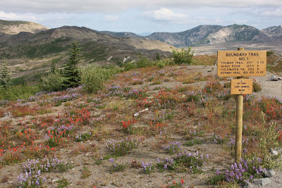
Wildflowers brightened the desolation

The weather report for last Sunday predicted cloudy skies, not favorable for mountain views. As I drove up the long winding road to the mountain, clouds hung low in the sky, and fog shrouded the adjacent hills.  But as I climbed the final steep pitch into the parking lot, the sky overhead cleared, and I was treated to a cloud-free view of Mt. St. Helens.


Orange paintbrush was everywhere

I began my adventure to trails lined with flowers.  They really brightened the surrounding desolate moonscape. The floral decorations continued for the next three miles, until I began my climb up Harry's Ridge. 


Trail junction

I made frequent photo stops to capture different views of the decapitated volcano. I was glad I did.  After the first hour, clouds began to gather around MSH's summit.  By the time I arrived at Harry's Saddle, the entire mountain was obscured in whiteness.


This butterfly posed for me


Last year I'd hiked to Harry's Ridge on a brutally hot day. I wanted to continue on to Coldwater Peak, but the heat did me in and I turned back. Today's weather was the exact opposite of last year's - cool and partly cloudy. Perfect for hiking!


Decapitated trees are reminders of the eruption

Today was my day to finally explore the Boundary Trail beyond Harry's Ridge.  This was a trail I'd wanted to hike for several years.  From Harry's Saddle, the path climbed steeply up the side of a hill littered with bleached stumps of trees sheared off by the blast.  An eerie reminder of that fateful day.


View back towards MSH - the sky is clouding up

As I gained elevation, the views of Spirit Lake got better and better.  The sky was mostly clouded over by then, so there were no mountain views.  On a clear day I'm sure there's a wonderful panorama of peaks visible from here. 


Beautiful St. Helens Lake

On top of the ridge was a breathtaking sight - deep blue St. Helens Lake ringed by mountains. I could see Coldwater Peak, my day's destination off to the NW side of the lake.


The rock arch

The trail dipped down a steep incline, and through a cool rock arch.  What an interesting rock formation it was!


Gorgeous paintbrush

Around the arch, flowers began to appear again.  The adjacent hillside was ablaze with paintbrush and other colorful blooms.


View through the arch

And the view through the arch couldn't be beat.  I'll bet it's even better on a clear day.


Coldwater Peak

On the top of the ridge right before the arch, I got my first close up of Coldwater peak.  Boy that mountain looked high!  Wispy clouds were beginning to encircle the very top.  I decided I'd better not dawdle too much, or things would be socked in once I reached the summit.


Beautiful lupine and St. Helens Lake

On the other side of the arch, I emerged into a lush green alpine meadow with tons of blooming lupine.  St. Helens Lake's lovely blue waters provided the perfect backdrop.  It was truly a beautiful place.  My goal of reaching Coldwater peak before the advancing clouds was forgotten as I filled my camera's memory card.


The lupine was thick here

I continued through the meadow until it intersected with the trail up to Coldwater Peak. Then began the trek up to the top of the mountain.


View from my lunch spot

I was getting tired and hungry and wasn't thrilled about another steep climb.  It was way past lunchtime, and my stomach let me know it.  The top of the peak was clouding over fast.  I was losing my enthusiasm for tagging the summit. 

Two lake view - St. Helens and Spirit Lake

I made it about 2/3 of the way to the top and spied a beautiful view point overlooking the lake. I decided then and there I'd gone far enough and made this my lunch spot.


Pano view from the lunch spot

The views were grand indeed. Not only did I have a nice overview of St Helens Lake, I also got views of Spirit Lake just beyond the surrounding hills. If the sky hadn't been cloudy, I think Mt. Adams would've shared the spotlight. Tons of flowers were blooming along the slopes, adding color to the scene.


Spirit Lake views from the return trail

I could've stayed here all day, soaking in the scenery.  But it was already mid-afternoon, and I had a long hike back and even longer drive home.  Reluctantly I packed up and bid my lunch spot goodbye.


Introducing......Spirit Lake!

The light was really nice on the way back. It lit up Spirit Lake turning its waters a gleaming blue. Lots of good photo ops on the return trip too!


Flower fields

Even though clouds obscured MSH in the afternoon, there was lots of other incredible scenery to take in.  I can't get over the desolation that is still present the closer you get to the crater.  It's like the eruption baked everything and rendered the soil sterile.  But slowly life is returning.  Green plants are tucked into ravines.  Flowers rise out of the sandy soil.  Butterflies soar above. Chipmunks skitter through the vegetation.


Back at the trailhead

Hiking this trail will definitely become an annual tradition.  I was amazed by the beauty of the terrain beyond Harry's Ridge.  I'd love to see this area on a clear day.  I'm sure it's even more incredible!  And next time I'll make it all the way up Coldwater Peak.

Total stats:  12 miles round trip, 2000' elevation gain.

Yep, it was a great day!

Thursday, August 18, 2011

Zucchini Overload

If there is one thing our family does, and does well, it's growing zucchini.  My hubby is the farmer of the family, and every spring plants a large vegetable garden in our backyard.  There is always one hill of zucchini included in the veggie selection.  As everyone knows, zucchinis seem to multiply like rabbits.  By August we usually have more of these lovely green squashes than our family can ever eat.  Over the years we've established a reputation as the neighborhood zucchini provider.


Roger's gigantic zucchini plants

However, 2011 was a record-setting year for our zucchini crop. The spring was notoriously cool and wet.  Roger planted the garden later than usual, and then jetted off to China the first two weeks of May.  When he returned from his trip, most of the veggies were breaking through the soil, but not the zucchini.  It appeared the seeds had failed to germinate.  So Roger dug another hole, and buried more zucchini seeds.


Double-decker squash

Fast forward a couple of weeks into the month of June.  After one of the few sunny days we had that month Roger noticed something scary was happening in the garden.  BOTH zucchini hills had germinated, and were sprouting lots of plants.  And very large plants at that.  Uh-oh.......


Zucchini plants do produce nice flowers

In late July, when the sun finally decided to shine for more than two consecutive days, Roger began to notice tons of tiny green squashes emerging from the zucchini vines.  The sunshine acted like miracle grow for those little guys.  They seemed to get bigger by the minute.  Roger would notice a zucchini that was the right size for eating one day, and return to the garden the very next day to find it had mushroomed into a monster!


And that's not all of it!

This week we found the motherlode of zucchinis residing in our little garden.  Hidden under the plant's leaves, Roger discovered mass quantities of zukes.  There was so many, they were stacking up on top of each other!   Roger picked half a dozen honkin' big squash.  I got out my zucchini bread recipes and prepared to bake.  Roger took a few of the big mothers to work, hoping to pawn them off on unsuspecting co-workers.


What am I gonna do with it all???
 
So what does one do with an overabundance of zucchini?  I can only bake so many loaves of bread. We gotta do something quick before the zucchinis take over our yard!  I may resort to anonymously leaving them on my neighbor's doorsteps at night. 

For the love of god, help us please!!

:)

Monday, August 15, 2011

Smith Rock

I took the Monday after the Haulin' Aspen half off from work.  I really didn't want to run a race and then have to drive 3 1/2 hours home on the same day.  This bonus vacation gave me an entire day to leisurely travel from Bend back to Portland.  And provided the perfect opportunity to visit Smith Rock State Park.


Smith rock rises from the valley floor

Smith Rock State Park is a spectacular canyon of multicolored rock spires and crags that rises above the high desert of Central Oregon.  Millions of years ago this place was a major center of volcanic activity.  Many lava flows into the valley forced the Crooked River out of its banks, and it began to erode the interior of a volcanic vent.  The erosive power of the river created sheer rock cliffs and majestic pinnacles.  The colorful formations are known as "welded tuff" - volcanic ash erupted under extreme heat and pressure.  Because of the abundance of steep rock walls, Smith Rock is a world-renowned destination for rock climbing.


Amazingly beautiful rock formations

I think Smith Rock is one of the coolest places in Oregon. The nerdy geologist in me loves this kind of stuff.  The rock formations here rise out of the plains, visible for miles. Every time I've traveled back and forth from Bend, Smith Rock's colorful pillars beckoned from the highway. I'd always tell myself that someday I was going to stop and check it out. I was able to squeeze in a brief stop couple of years ago, but that visit just whetted my appetite for more.


Yellow flowers and red rock

So here I was, with an entire day to kill, ready to finally explore this wonderful place.  I tried to get an early start, because in the summer this area heats up quickly.  Temps in the upper 90's are not uncommon.  It's better to visit Smith Rock in the spring or fall, when weather conditions are more moderate.  But this was the time I had available, and I was going take advantage of it, heat or not.  I tanked up on water, made sure my camera's memory card was empty, and hit the trail.


Rock climbing is big here

I followed the trail that paralleled the Crooked River.  From the beginning the views were incredible.  The rock cliffs rose high above me, jutting out of the valley floor.  They made nice reflections into the river.  The vegetation along the waterway was a deep green, making a nice contrast with the reddish rock.


A climber ascending the rock wall

There were a couple of climbers inching up the stony walls.  I stood and watched one person for several minutes.  Pretty amazing stuff!  I don't know how they find their hand and foot holds.  The cliff surface looked very smooth - there didn't appear to be much one could grab onto.  I admire the people who do this sport, but it is definitely not for me!


The Crooked River runs through it all

The Crooked River trail wound its way around the Smith Rock formation.  A few flowers were blooming and the grasses lining the river looked very lush and green.  The sun beat down, and it began to get really hot.  Luckily, the looming rock towers provided some shade, which was most welcome.


Purple thistle

For a Monday morning, I ran into a surprising amount of people.  I thought I'd have the place to myself.  Guess everyone else was on vacation too!


The Monkey Face

I rounded a bend in the river, and up ahead I spied the Monkey Face rising out of the rock walls.  The Monkey Face is a well-known rock formation.  The top cap of the spire looks like the face of a monkey (thus it's name).  This famous pinnacle is scaled by lots of climbers. 


Beautiful yellow flowers

The nice shade provided by the rock walls ended just in time for the trail to ascend steeply up to the top of the ridge.  And it was a climb! 

This way to the Monkey Face

It didn't help that I hit the switchbacks at mid-day and the sun was high overhead.  I sucked down lots of water while trudging uphill.


Snow-capped mountain views

But the climb provided big rewards.  Slowly, snow-capped peaks of the Central Oregon Cascades popped above the horizon.  I could see Mt. Bachelor, Broken Top, the Three Sisters, Black Butte, Mt. Washington, Three-Finger Jack and Mt. Jefferson.  And a ghostly apparition of Mt. Hood appeared far to the north.  It was a wonderful parade of mountains adorning the skyline.


Mt. Jefferson sighting

Mt. Jefferson, the closest mountain, dominated the view directly west.


The Monkey Face watches over Central Oregon

The trail snaked up the steep slope around the base of the Monkey Face.  I climbed until I was almost even with the towering formation.  The panorama extended towards the Central Oregon farmlands, with the Monkey Face in the foreground, and Mt. Jefferson anchoring the horizon.  A grand view indeed!


The monkey and me

At the top of the ridge, a trail for very brave hikers led people out onto a precipitous rock spire directly opposite the Monkey Face.  I didn't opt to try this trail, but a young man who arrived the same time as I headed straight for it.  On his way down to the pillar, I heard a loud yelp.  The guy hollered that he'd just had a close encounter with a rattlesnake.  As if standing on the edge of a sheer dropoff wasn't enough, the thought of a nearby snake made me decide to stay put and admire Monkey Face from the safe haven of the main trail!


Path down the canyon

I followed the trail across the top of the ridge.  My map showed this place was nicknamed "Misery Ridge."  By now the sun was really beating down.  I was hot, sweaty, almost out of water, and not entirely feeling my best.  Yep, this place was aptly named!


River level view of the rock formations

At the east end of the ridge a series of wooden steps led hikers back down to the river bottom.  The scenery was just as awesome on this side. The path wound through beautiful red rock walls.   My descent provided a front row seat to the panorama of rocky spires stretching to the east.  A large row of colorful cliffs bordered the Crooked River as it snaked through the valley floor.  A great way to end such a wonderful hike!


Around the river bend

I arrived back at my car hot and thirsty, but very happy.  A very successful reconnaissance of Smith Rock!  I was able to explore a large portion of the park.  My camera was full of great photos.  And I worked the lactic acid from the previous day's race out of my muscles.

Now next time I see Smith Rock from the highway, I'll know exactly what's hidden within those soaring rock pillars.  Problem is, I'm so smitten with the place, I probably won't pass it by again.