Monday, February 28, 2022

A (very!) Early Morning Trip to Mt. Hood

I have a confession to make......I love photographing sunrises, but hate getting up early.  Yes, I realize these are two diametrically opposing goals.  But I've discovered one of the wonderful perks of retirement is the opportunity to sleep in every day.  And I love to sleep in.  So although rising early to capture a sunrise seems like a good idea the night before, when the alarm rings at o-dark-hundred my drowsy brain says "what was I thinking?" and goes right back to sleep.


Mt Jefferson view from Timberline parking lot

Where I live January is a great month to catch sunrises.  Not only are there interesting and often colorful clouds at dawn, the sun doesn't peek above the horizon until well after 7 am.  You would think the day's later start would help with my rising early problem.  However, in early January I really wanted to capture sunrise over Mt Hood.  Reaching Mt. Hood required an hour and a half drive, which still meant a very early wake up call.  I planned several sunrise photo sessions in January, only to talk myself out of it at when it came time to actually get out of bed.


Pink skies at dawn

But finally one Friday in mid-January I was successful.  The weather looked promising for a colorful sunrise on the mountain.  Inspired by the good conditions and fear of missing out yet again, I somehow got my lazy butt out of bed and into my car.  I'd initially thought of hiking into Trillium Lake and capturing sunrise there, but decided I didn't want to hike to the lake in the dark (and it would take too much time, requiring an even earlier start).  Instead, I decided to drive up to Timberline Lodge and capture sunrise there.  


Colorful skies above Mt Hood

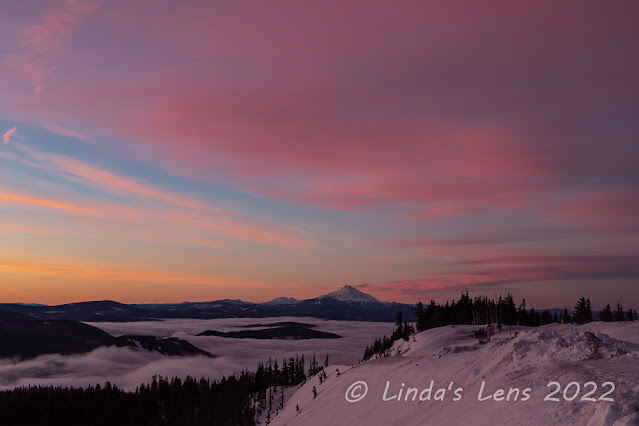
Although I thought I'd risen early enough to get to Timberline in time, when I pulled into the parking lot, the sky was already turning colors.  Opening my car door, I was buffeted by a gust of wind.  Not only was it frigidly cold, the wind was absolutely howling!


Predawn pastels

I hurriedly pulled on some layers and wrestled my tripod to the parking lot edge.  I didn't have time to hike anywhere, the sunrise was already happening.  With one hand on the shutter and the other on my tripod leg, I pointed my camera at the southern horizon, where the sky was turning a lovely shade of pink.  Mt Jefferson anchored the skyline as the clouds above her began to display hues of pink, orange, and blue.


Morning light turning the slopes pink

Although my hands were freezing, I tucked one, then the other, under my armpit and kept on shooting.  The sky was changing so fast I didn't want to miss anything.  Fierce wind gusts rattled my tripod, and I had to hold onto one of the legs to prevent it from blowing over.  


Another zoomed-out view

Not only was the show to the south and east.  Looking behind me to the north, Mt Hood was beginning to show a bit of color.  First, the sky above the mountain began displaying pastel hues of pink and blue.  Then as the sun broke above the horizon, a tiny bit of pink lit up the snow just below the summit.  Alpenglow!


First sunrays on the mountain

Finally the sun's rays crested over the foothills, casting dramatic light on the mountain's east side.  This illuminated small clouds of snow whipped up from the strong winds.  It was fascinating to watch and photograph.


The morning fog has frosted the forest

With the sun now rising in the sky, it was time to jump back in my car and warm up.  Blasting the heater, I pondered my next move.  The day was still early, so I decided why not hike into Trillium Lake and check things out?  So downhill I drove, following windy Timberline Road to the main highway.  From here, it was a mere couple of miles to the Trillium Lake Snopark.


Beautiful icy trees

During summer months, one can drive to the shore of Trillium Lake.  In winter, the Forest Service closes the road, and people ski, snowshoe, or hike the two miles to visit the lake.  It's easy access from the highway and short distance makes this a popular destination when the snow flies.  But today I was surprised to find only one other vehicle in the parking lot when I arrived.  


Snowy wonderland

The Mt. Hood area hadn't received any measurable snowfall for two weeks, so I found the snowy trail to the lake well packed - solid enough that I left my snowshoes in the car and hoofed it on foot.


The snow-covered sign 

I was surprised to find a thick fog bank had descended upon the area.  From up high at the Timberline Lodge parking lot, I'd seen fog collecting the valleys but didn't realize it was at Trillium Lake's elevation.  Good thing I didn't try and hike in here to catch sunrise!  It would've been a long trek in the dark for nothing. But a wonderful effect of the fog had coated the trees in ice.  The forest along this closed road had been transformed into a glittering, frosty wonderland!  My camera came out right from the start, and let's just say I didn't make record time getting to the lake. 


Almost there!

Winter storms the first week of January had dumped massive amounts of snow in the Cascades.  Cold weather had preserved this generous snowfall.  I was amazed to see the road signs partially covered up by the white stuff.  I didn't realize how deep the snowpack was until I stepped off the well trod path into untracked snow and promptly sank to my hips.  Lesson learned!  Stay on the path!


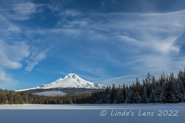
Classic Mt Hood view from Trillium Lake

But finally I recognized the partially buried Forest Service sign directing travelers to Trillium Lake.  Following the side road through the trees (staying on the packed snow, of course!) led me to the boat dock.  Early morning fog now lifted, I was treated to a classic blue-sky Mt. Hood view from the lake.  


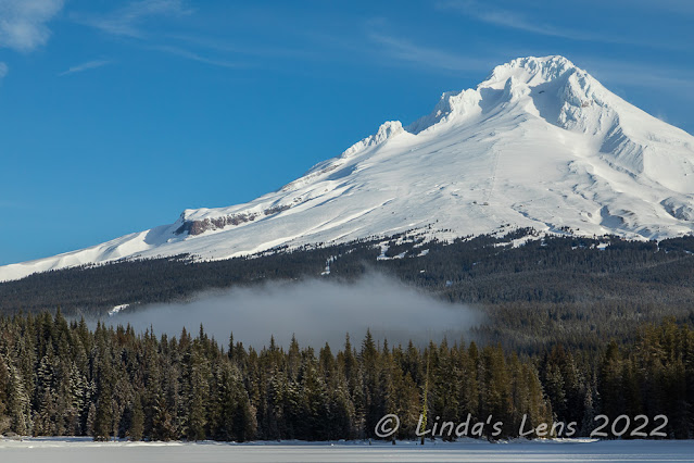
Last of the fog lifting from the lake

In the summer Trillium Lake is a popular spot for fishing.  The Forest Service built a large wooden dock near the boat launch to facilitate those fisherpeople lacking watercraft.  Today I was very surprised to find the dock full to the railings with snow.  


The fishing dock is full of snow!

It's been a tradition of mine to get a winter selfie on Trillium Lake's fishing dock.  This year I was actually "on top" of the dock!  I was thrilled to have the entire lake to myself for nearly 20 minutes while sitting at the dock area enjoying hot tea and snacks.


Selfie on the fishing dock

The views were so tremendous, I walked around the lake towards the dam for more photo ops.  Although the lake appeared to be frozen over, I wasn't about to venture out and test the ice.  I spied a small rift in the ice near the dam, and upon further inspection, was delighted to discover a reflection of Mt. Hood in the open water.


Mt Hood reflection 

I began to see a few skiers sliding along the top of the dam.  Then a group of snowshoers clomped through the forest to lake's edge.  The world had woken up, and the masses were coming.  Although I'd enjoyed my minutes of solitude at Trillium Lake, I took this as my cue to head back.


Icy trees beginning to melt

The road back to the snowpark was like a superhighway.  A nearly continuous conga-line of skiers, snowshoers, and hikers (with their dogs) were heading towards the lake.  Now I was extra thankful I'd listened to my alarm this morning.  Not only does the early bird get the sunrise, she also gets Trillium Lake to herself!  

I'd like to say this experience has turned me into more of a morning person......but I've risen early for exactly one sunrise since that day!  Maybe posting my photos and writing about this trip will inspire me to take more early outings.


Monday, February 21, 2022

Discovering Stub Stewart State Park

My quest to find new hiking trails has forced me to check out previously overlooked places closer to home.  In this case, I'd heard about Stub Stewart State Park many years ago, but due to its proximity to the Portland metro area, wrote it off as someplace that didn't sound very interesting.

Well... I couldn't have been more wrong!


Foggy morning

Most of the trails I regularly hike are located east of home, necessitating a two-way drive through Portland traffic.  Not keen on dealing with big city gridlock, one foggy, cold morning in mid-January had me searching for trails on my side of town.  Then I remembered Stub Stewart State Park.  A mere 30-some miles west of my house, I'd passed the signs for this place many times on the way to the coast.  A quick online search yielded a plethora of short, but interconnected trails in this 1,800-acre park (nearly 30 miles of trails according to it's website).  I decided it was time to finally put some boots on the ground and explore Stub Stewart!


Interesting trail names here!

Once I reached Stub Stewart, my first stop was the visitor center.  Being a state park, I knew I'd have to purchase a day parking pass and reasoned the visitor center was the place to get one.  Luckily, I happened to meet up with a very friendly volunteer who graciously suggested trails to try, providing directions for three different routes, along with an overall park map.  With the large number of hiking and mountain bike trails here, this map was invaluable.  The park volunteer directed me to the Hilltop Day-use Area, which provided easy access to many of the hiking trails, as well as other outdoor recreation. 


Cabin village

Parking my car in the spacious lot at the Hilltop Day-use Area, I considered my options.  Numerous hiking trails branched out in all directions from here.  Which one should I try first?  After a few minutes of pondering I decided upon starting on the Boomscooter Trail and then following the Barberchair Trail towards the Banks-Vernonia State Trail.  The hiking trails here were plentiful and short, so getting some decent milage involved creating a route by cobbling together several of them.  I took off from the parking lot, and a quarter mile later passed by the Mountain Dale Cabin Village.  Fifteen cabins perched on top of a ridge, with wide-open views of the surrounding forest and coast range (at least, I assumed that was the case, it was still too foggy to tell!)  I made a mental note to check out renting one of these cabins for a future midweek overnighter.


Nice spot for a break

As you've already seen, many of the trails here had funny names.  Because logging was a big industry back in the day, a lot of these names were logging related.  It appeared most of the park's forest was comprised of second-growth trees, leading me to believe this entire area had been logged at some point.


Red arrows point the way

I was delighted to find the Boomscooter and Barberchair Trails wide, free of debris, and well-signed.  At junctions, not only signs, but large red arrows pointed the way.  


Nice, wide trail

I wound through standard coast range forest, full of green coniferous trees, moss, and an abundance of ferns.  Yes, it was second growth timber, but I found the woods here absolutely delightful.


It isn't the coast range without lots of ferns!

With a bit of online research I learned that Stub Stewart State Park opened in 2007 and had the distinction of being the first new full-service state park in Oregon since 1972.  The name honors lumberman and state representative Loren LaSells "Stub" Stewart, who passed away in January 2005.  Stub Stewart served an extended time on the Oregon Parks and Recreation Commission, as well as being a co-owner of a lumber company and prominent philanthropist.  The Banks-Vernonia State Trail, a 21-mile paved "rails to trails" bicycle and hiking path, passes through this park.


Alder tree forest

In addition to hiking trails and cabins, Stub Stewart State Park also boasts 15 miles of mountain bike trails, three campgrounds, a horse campground as well as equestrian trails, two disc golf courses, a playground, and two meeting halls and a large picnic shelter that groups can reserve for events.  They even allow stargazing on clear nights.  There's something here for everyone!


Fog made the Banks-Vernonia Trail look spooky

Back to my hike - after following the Barberchair Trail for a half mile or so, it intersected with the Bark Spud Trail, which I followed a short distance to the paved Banks-Vernonia Trail.  It was still very foggy out, and these misty clouds made the forest look downright spooky.


Beaver pond

Next on the route - following the Banks-Vernonia Trail 3/4 of a mile to a large beaver pond.  No beavers to be seen today, but this pond marked the junction of the Boomscooter Trail, the next leg of my hiking journey.


Muddy trail by the ponds

The Boomscooter Trail led me through more dense forest and past another pond.  (Named - you guessed it - Boomscooter Pond!)  The tread was really muddy here and although I tried to avoid the muck, you couldn't help but get your boots and pant legs dirty.


Lovely green forest

Heading uphill from Boomscooter Pond, the forest was especially green and plush.  By now, the sun was occasionally breaking through the fog, creating some nice light on the mossy trees.


Backlit moss hanging from trees

As you can see, progress through this stretch of trail was a wee bit slower.......


Peek-a-boo pond view

Finally the Boomscooter Trail intersected with two other trails.  One appeared to lead towards a viewpoint.  Although I like hiking through forests, after two miles I was ready to see some views.  I decided to take this trail - named the "Unfit Settlement" - to the Skycar Viewpoint.


More mossy trees

More uphill trudging ensued.  But this new trail with yet another weird name wasn't ever that steep.  And it didn't take long to reach the junction with the short trail leading to the Skycar Viewpoint.


Skycar viewpoint

Although the trails at Stub Stewart were never very crowded (and I was here on a Saturday) I assumed I'd encounter people at this viewpoint.  But luck was with me yet again.  Approaching the Skycar Viewpoint, I was delighted to find I had the place to myself.


Foggy forest view

There was a nice large bench situated so one could sit and take in the views.  By now the fog was starting to lift, and I could actually see a bit of the far hills and nearby forest.  Since it was past lunchtime, I took full advantage of the prime seating for an extended break.


Nice panorama from Skycar viewpoint

As I ate my lunch, the clouds lifted further and I even began to see blue sky!  By the time I was finished over half the horizon was clear of fog.  Yeah!


Taking in the scenery

I was visited by only one other group the entire 20 minutes or so I was at the viewpoint.  For a busy Saturday, I thought that wasn't too bad.  After downing my sandwich and taking copious photos from all angles, I decided it was finally time to move on.


Rambling through a second growth forest

The Unfit Settlement Trail contoured along a high ridge, its slopes falling steeply towards the West Fork of Dairy Creek.  After my hike, I read somewhere that a 19th century surveyor working in the area didn't think much of the homesteading potential, and gave it a very unflattering assessment.  I guess that's where the "unfit settlement" moniker came from, but what a funny name to give a trail!


Very strange trail names here!

There was another viewpoint along the Unfit Settlement Trail, so of course I had to check it out.  I climbed and climbed, and finally reached the second viewpoint.  At an elevation of 1,528 feet (the highest point in the park) you would think the views here would be tremendous.  Sadly, the place was ringed by a large number of tall trees, with only a small opening offering glimpses towards the coast range.  The Skycar was a much better viewpoint.  I was glad I'd spent my lunchtime there instead.


Trees dripping with moss

From this second viewpoint, the trail plunged downhill in a muddy, rocky grade.  The roughest trail I trod on that day, I really had to watch my step.  But finally it intersected with the Hares Canyon Trail, a much wider, smoother path.  From here, I enjoyed a easy trek through an incredibly beautiful mossy forest.


Granddaddy tree

This was probably the most interesting of the forests I'd hiked through.  I loved all the green, moss-draped trees.  Lots of photo subjects here, and again my forward progress was slowed.


Afternoon light in the forest

The Hares Canyon Trail passed by a designated mountain biking area.  Although all the park trails allow mountain biking, this portion was set aside specifically for bikes only.  I did see a couple of mountain bikers on the trails I hiked, but it appeared most of the two-wheeled guests chose to recreate here.


Moss close-up

My loop route was now taking me back towards the Hilltop parking area.  I passed through an area of extremely dense forest where beams of sunlight filtered through gaps in the trees.  It was much more beautiful than my photos portrayed, and a fitting end to a great day in the woods.  

Finally, I climbed a short uphill stretch via the Bullbucker Trail, through a frisbee golf course, and emerged from the forest onto a main park road.  Across the road was the parking lot and my car.


Sunrays filter through the dense forest

I've found another great place to hike close to home that doesn't require a trip through city traffic.  I barely scratched the surface of the many trails here at Stub Stewart State Park, so you can bet I'll be back soon to explore a few more.  (And also laugh at the funny logging slang used to name most of the trails here!)


Saturday, February 12, 2022

Fabulous Day at the Coast

I'm a mountain gal.  Even though the Oregon coast is an hour's drive away, most of my time is spent traveling in the opposite direction to high, snowy places.  But every once and awhile I get a hankering for sea breezes.  The first full weekend in January was one of those times.  So I recruited my friend, neighbor, and photo-buddy Cheri for a day of photography at the coast.


Hug Point Beach

Hug Point Beach is one of my favorite places on the northern Oregon Coast.  It looked like we'd hit low tide in the morning, so Cheri and I timed our arrival accordingly.  However, I soon realized low tide in the winter is much different than during the summertime.  The water level was much higher, so high in fact that the old wagon road blasted into a nearby cliff face was still submerged at low tide.  Guess we wouldn't be walking on that!  


Hug Point Falls 

But the previous week's heavy rainfall translated into a wide, roaring waterfall nearby.  Normally just a trickle, I'd never seen Hug Point Falls moving so much water!  Getting to this rushing cascade required Cheri and I to walk across a headland jutting into the sea.  We'd donned our high rubber boots for the occasion and waited for a lull in the waves before venturing out.  But a sneaker wave caught us as we crossed, topping boots and soaking feet.  Oh well, at least we escaped with only wet feet.  That's why you bring extra pairs of socks when you go to the beach.


Moving water close-up

Hug Point Falls was quite beautiful.  The high volume of water racing over its sandstone cliff made this cascade fun to photograph.


Cheri and Stella

Cheri's dog Stella joined us for the day.  She's a purebred Australian Shepherd, smart and very well trained.  Of course all dogs love to run on the beach and find sticks to fetch, and Stella joyfully did both.


Who's a good dog?

Have you ever seen a happier doggo?


Peter Iredale shipwreck

After an hour or so of beach and waterfall photography, we drove further south to Nehalem Bay State Park.  Remembering my elk herd sightings here last fall, Cheri and I were hoping to spot a few of these magnificent animals.  But - alas - there were none to be found.  Not even a bird to photograph!  


Close-up of ship remains

So we headed back north, all the way up to Fort Stevens State Park, where we walked along the beach to find the wreck of the Peter Iredale.  This ship was traveling along the Oregon Coast in 1906 when it ran aground, hitting so hard that three of her masts snapped from the impact.  Since then, the shipwreck has been a popular tourist attraction.  But wind and waves have worn away at the vessel for years, and now only a small portion of her frame remains.  Despite this, it still makes a great photo subject.


Speedy shorebird

Cheri spotted a small flock  of shorebirds racing around the sand.  (I believe they may have been snowy plovers, but I'm still learning my birds, so please correct me if I'm wrong!)  It was fun, but challenging to capture these speedy little buggers.


Surprise elk sighting in Seaside

By now it was late afternoon.  Time to head back to Cannon Beach to catch the sunset.  As we drove towards Cannon Beach, Cheri noticed a bunch of vehicles parked in a gravel pull-out on the outskirts of the town of Seaside.  What had caused all these vehicles to stop?  A huge herd of elk was happily grazing, just a stone's throw away from a residential neighborhood.


Just chillin'

We'd been driving around all day looking for elk, and here they were practically in town!  Who would've thought?  Of course Cheri and I pulled over and jumped out, zoom lenses in hand.  We stuck out in the crowd of people, most only armed with cell phone cameras.


Waiting for sunset at Cannon Beach

As we turned onto the exit for Cannon Beach, Cheri spotted another elk herd happily munching the landscaping in the highway median.  But there wasn't time to photograph these elk - we had a sunset to catch!


Famous Haystack Rock in the distance

It was a long walk from our parking area to Haystack Rock, the huge seastack that Cannon Beach is famous for.  The sun was dropping fast, turning skies and sand a kaleidoscope of colors.  The sunset began before I could make it to the rock, so I plopped my tripod down and captured the show from where I stood.


Sky colors reflected in the water


It wasn't too shabby of a spot.  I was able to get Haystack Rock and its accompanying seastacks from one direction, and the southern coastline from the other.  And right before me the sky colors were reflecting beautifully in the rippled waters of the beach.


Pink skies


Then the clouds to the west turned a vibrant shade of pink.  Oh my!  I didn't think things could get better, but they did!


Nice color to the south too


After the sun finally sank below the horizon, I thought that would be it.  I couldn't have been more wrong.


The show went on and on...


Shades of yellow, orange, red and pink lingered in the sky.  The sunset show was just getting started.


Small creek empties into the sea


This colorful sky persisted for several minutes.  Although Cheri and I were getting cold, and still had a long walk back to our car, it was so amazing we couldn't tear ourselves away.  We'd walk a few steps, and then spot a scene just begging to be photographed.  Such as a small creek flowing towards the ocean,  its rippled boundary lit up beautifully by the sky.  One of my favorite images of the evening.


Final shot


Yes, it was a good day on the coast.  Not only did we catch Hug Point Falls at maximum flow, Cheri and I also got to photograph a vanishing shipwreck and herd of elk, capped off by capturing a stunning sunset.  Mission accomplished!