
My quest to find new hiking trails has forced me to check out previously overlooked places closer to home. In this case, I'd heard about Stub Stewart State Park many years ago, but due to its proximity to the Portland metro area, wrote it off as someplace that didn't sound very interesting.
Well... I couldn't have been more wrong!
 |
| Foggy morning |
Most of the trails I regularly hike are located east of home, necessitating a two-way drive through Portland traffic. Not keen on dealing with big city gridlock, one foggy, cold morning in mid-January had me searching for trails on my side of town. Then I remembered Stub Stewart State Park. A mere 30-some miles west of my house, I'd passed the signs for this place many times on the way to the coast. A quick online search yielded a plethora of short, but interconnected trails in this 1,800-acre park (nearly 30 miles of trails according to it's website). I decided it was time to finally put some boots on the ground and explore Stub Stewart!
 |
| Interesting trail names here! |
Once I reached Stub Stewart, my first stop was the visitor center. Being a state park, I knew I'd have to purchase a day parking pass and reasoned the visitor center was the place to get one. Luckily, I happened to meet up with a very friendly volunteer who graciously suggested trails to try, providing directions for three different routes, along with an overall park map. With the large number of hiking and mountain bike trails here, this map was invaluable. The park volunteer directed me to the Hilltop Day-use Area, which provided easy access to many of the hiking trails, as well as other outdoor recreation.
 |
| Cabin village |
Parking my car in the spacious lot at the Hilltop Day-use Area, I considered my options. Numerous hiking trails branched out in all directions from here. Which one should I try first? After a few minutes of pondering I decided upon starting on the Boomscooter Trail and then following the Barberchair Trail towards the Banks-Vernonia State Trail. The hiking trails here were plentiful and short, so getting some decent milage involved creating a route by cobbling together several of them. I took off from the parking lot, and a quarter mile later passed by the Mountain Dale Cabin Village. Fifteen cabins perched on top of a ridge, with wide-open views of the surrounding forest and coast range (at least, I assumed that was the case, it was still too foggy to tell!) I made a mental note to check out renting one of these cabins for a future midweek overnighter.
 |
| Nice spot for a break |
As you've already seen, many of the trails here had funny names. Because logging was a big industry back in the day, a lot of these names were logging related. It appeared most of the park's forest was comprised of second-growth trees, leading me to believe this entire area had been logged at some point.
 |
| Red arrows point the way |
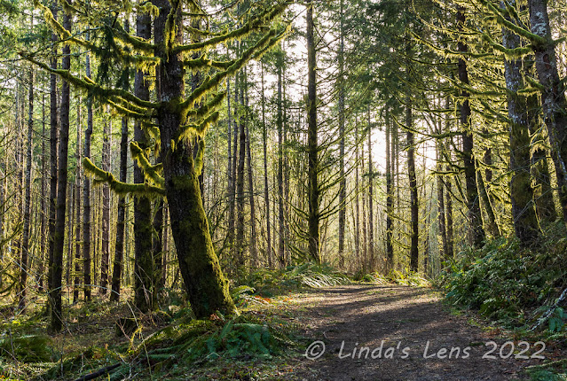
I was delighted to find the Boomscooter and Barberchair Trails wide, free of debris, and well-signed. At junctions, not only signs, but large red arrows pointed the way.
 |
| Nice, wide trail |
I wound through standard coast range forest, full of green coniferous trees, moss, and an abundance of ferns. Yes, it was second growth timber, but I found the woods here absolutely delightful.
 |
| It isn't the coast range without lots of ferns! |
With a bit of online research I learned that Stub Stewart State Park opened in 2007 and had the distinction of being the first new full-service state park in Oregon since 1972. The name honors lumberman and state representative Loren LaSells "Stub" Stewart, who passed away in January 2005. Stub Stewart served an extended time on the Oregon Parks and Recreation Commission, as well as being a co-owner of a lumber company and prominent philanthropist. The Banks-Vernonia State Trail, a 21-mile paved "rails to trails" bicycle and hiking path, passes through this park.
 |
| Alder tree forest |
In addition to hiking trails and cabins, Stub Stewart State Park also boasts 15 miles of mountain bike trails, three campgrounds, a horse campground as well as equestrian trails, two disc golf courses, a playground, and two meeting halls and a large picnic shelter that groups can reserve for events. They even allow stargazing on clear nights. There's something here for everyone!
 |
| Fog made the Banks-Vernonia Trail look spooky |
Back to my hike - after following the Barberchair Trail for a half mile or so, it intersected with the Bark Spud Trail, which I followed a short distance to the paved Banks-Vernonia Trail. It was still very foggy out, and these misty clouds made the forest look downright spooky.
 |
| Beaver pond |
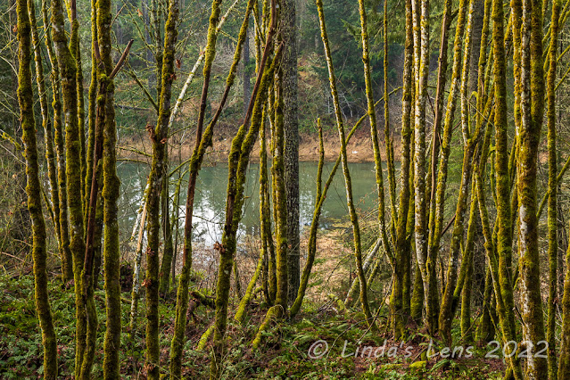
Next on the route - following the Banks-Vernonia Trail 3/4 of a mile to a large beaver pond. No beavers to be seen today, but this pond marked the junction of the Boomscooter Trail, the next leg of my hiking journey.
 |
| Muddy trail by the ponds |
The Boomscooter Trail led me through more dense forest and past another pond. (Named - you guessed it - Boomscooter Pond!) The tread was really muddy here and although I tried to avoid the muck, you couldn't help but get your boots and pant legs dirty.
 |
| Lovely green forest |
Heading uphill from Boomscooter Pond, the forest was especially green and plush. By now, the sun was occasionally breaking through the fog, creating some nice light on the mossy trees.
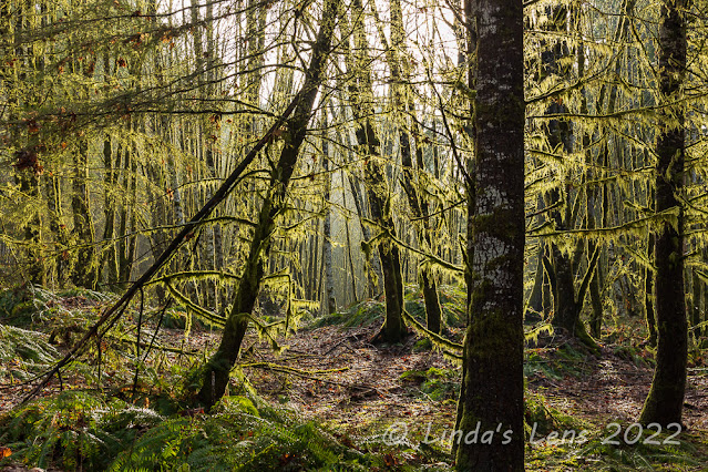 |
| Backlit moss hanging from trees |
As you can see, progress through this stretch of trail was a wee bit slower.......
 |
| Peek-a-boo pond view |
Finally the Boomscooter Trail intersected with two other trails. One appeared to lead towards a viewpoint. Although I like hiking through forests, after two miles I was ready to see some views. I decided to take this trail - named the "Unfit Settlement" - to the Skycar Viewpoint.
 |
| More mossy trees |
More uphill trudging ensued. But this new trail with yet another weird name wasn't ever that steep. And it didn't take long to reach the junction with the short trail leading to the Skycar Viewpoint.
 |
| Skycar viewpoint |
Although the trails at Stub Stewart were never very crowded (and I was here on a Saturday) I assumed I'd encounter people at this viewpoint. But luck was with me yet again. Approaching the Skycar Viewpoint, I was delighted to find I had the place to myself.
 |
| Foggy forest view |
There was a nice large bench situated so one could sit and take in the views. By now the fog was starting to lift, and I could actually see a bit of the far hills and nearby forest. Since it was past lunchtime, I took full advantage of the prime seating for an extended break.
 |
| Nice panorama from Skycar viewpoint |
As I ate my lunch, the clouds lifted further and I even began to see blue sky! By the time I was finished over half the horizon was clear of fog. Yeah!
 |
| Taking in the scenery |
I was visited by only one other group the entire 20 minutes or so I was at the viewpoint. For a busy Saturday, I thought that wasn't too bad. After downing my sandwich and taking copious photos from all angles, I decided it was finally time to move on.
 |
| Rambling through a second growth forest |
The Unfit Settlement Trail contoured along a high ridge, its slopes falling steeply towards the West Fork of Dairy Creek. After my hike, I read somewhere that a 19th century surveyor working in the area didn't think much of the homesteading potential, and gave it a very unflattering assessment. I guess that's where the "unfit settlement" moniker came from, but what a funny name to give a trail!
 |
| Very strange trail names here! |
There was another viewpoint along the Unfit Settlement Trail, so of course I had to check it out. I climbed and climbed, and finally reached the second viewpoint. At an elevation of 1,528 feet (the highest point in the park) you would think the views here would be tremendous. Sadly, the place was ringed by a large number of tall trees, with only a small opening offering glimpses towards the coast range. The Skycar was a much better viewpoint. I was glad I'd spent my lunchtime there instead.
 |
| Trees dripping with moss |
From this second viewpoint, the trail plunged downhill in a muddy, rocky grade. The roughest trail I trod on that day, I really had to watch my step. But finally it intersected with the Hares Canyon Trail, a much wider, smoother path. From here, I enjoyed a easy trek through an incredibly beautiful mossy forest.
 |
| Granddaddy tree |
This was probably the most interesting of the forests I'd hiked through. I loved all the green, moss-draped trees. Lots of photo subjects here, and again my forward progress was slowed.
 |
| Afternoon light in the forest |
The Hares Canyon Trail passed by a designated mountain biking area. Although all the park trails allow mountain biking, this portion was set aside specifically for bikes only. I did see a couple of mountain bikers on the trails I hiked, but it appeared most of the two-wheeled guests chose to recreate here.
 |
| Moss close-up |
My loop route was now taking me back towards the Hilltop parking area. I passed through an area of extremely dense forest where beams of sunlight filtered through gaps in the trees. It was much more beautiful than my photos portrayed, and a fitting end to a great day in the woods.
Finally, I climbed a short uphill stretch via the Bullbucker Trail, through a frisbee golf course, and emerged from the forest onto a main park road. Across the road was the parking lot and my car.
 |
| Sunrays filter through the dense forest |
I've found another great place to hike close to home that doesn't require a trip through city traffic. I barely scratched the surface of the many trails here at Stub Stewart State Park, so you can bet I'll be back soon to explore a few more. (And also laugh at the funny logging slang used to name most of the trails here!)
What a wonderful find for you. Fabulous images. Perhaps the foggy, cool conditions kept many away. It will be interesting to see how busy it is on next visit
ReplyDeleteIt's always good to find a new place to go, especially when it's relatively local. Someone had lots of fun naming those trails!
ReplyDelete...this was certainly worth the drive through traffic!
ReplyDeleteSuch a pretty state park! The life of retirement, having the time and flexibility to discover what's on the other side of those new doors that open!
ReplyDeleteSo much moss! Such lovely forests, but I agree, it is nice to have some views too. Looks like a great find close to home.
ReplyDeleteI do love those green rainforest trails!
ReplyDeleteA great find reasonably close to home. Looks wonderful with those moss covered trees.
ReplyDeleteI like the trail names, but I would have added my favorite logging term and designated a trail the Brush Fit Trail.
ReplyDeleteWow the moss is incredible! What a great hike closer to your home than the others!
ReplyDeleteYou always find something special wherever you go. Those cabins look really nice.
ReplyDeleteFotografias fantásticas desta caminhada.
ReplyDeleteUm abraço e bom fim-de-semana.
Andarilhar
Dedais de Francisco e Idalisa
O prazer dos livros
The moss-covered forest is amazing. Boomscooter may be my next screen name! ;-)
ReplyDeleteLoving those funny trail names - Boomscooter - I like that!
ReplyDelete