Saturday, May 23, 2020

Finally a Hike!

For seven long weeks I was good.  Even though it meant missing peak wildflower and hiking season, I dutifully stayed home.  But by the second weekend of May I was growing tired of the same old neighborhood jaunts.  After seeing a few hiking trip reports on Facebook, I knew it was time.  A bit of internet research revealed trails in the nearby Tillamook State Forest were very much open.  Time for some wilderness therapy - I was finally going on a hike!

Lush coastal forest

For my first post-COVID trek I picked a "new to me" route - a loop that included the Gales Creek Trail, Storey Burn Trail, and a short return on the Gravelle Brothers Trail.  With the trailhead conveniently located at the coast range summit along Highway 6, not only was it a short drive, I was also following the "don't travel more than 40 miles from home" directive (barely).


Bleeding hearts

I parked at the familiar summit trailhead.  Coincidentally it's also the trailhead for University Falls, which I've hiked several times before.  Today instead of crossing the highway, the trail began steps from my car door.  A huge bunch of bleeding heart flowers blooming around the trailhead kiosk delayed my start.  Photography began early today!


Oxalis

The Gales Creek Trail descended steeply downhill, past lush undergrowth full of blooming wildflowers.  Not only were bleeding hearts thick, so were lovely, ivory-colored fairy lanterns.


Ferns unfurling

It took a bit of extra time to complete my first mile.  So much to photograph!


Fairy lanterns

New ferns were unfurling their tiny green leaves from the main curving stalk.


Huge mossy tree

Although the forest was mainly second growth timber, a few giant, mossy trees could still be found.


Wildflower collage

Wildflowers stole the show.  Trilliums, yellow violets, more fairy lanterns and bleeding hearts, and bright yellow Oregon grape.  Every where I looked something was in bloom.
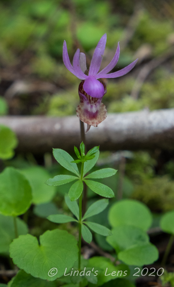

Fairy slipper

I was happy to spot three tiny fairy slipper flowers hiding on the forest floor.  Also known as Calypso Orchids, these lovely pink blooms are not super common, so it's always special if you see one.


Backlit new leaves

Although the morning started out cloudy, before long sunlight began to filter through the forest canopy, backlighting some of the bright green new leaves.


More bleeding hearts

Abundant rainfall always makes Coast Range forests super lush and green, especially in the spring.


One of many bridges

The path wound through thick forest, crossing several tiny tributary creeks.  But this well-maintained trail had sturdy wooden bridges spanning each of the crossings so I never got my feet wet.


Corydalis

After two lovely downhill miles, I came to the closed Gales Creek Campground.  With sites scattered along the banks of Gales Creek, it looked like a great place to spend a couple of nights.  As I climbed away from the creek, I clicked a few photos of pink corydalis blooms and new, bright green ferns.


New, green fern

And Gales Creek also made for some lovely scenery.


Gales Creek

Although the Coast Range is the closest forest to my home, I don't often hike here.  These forests, heavily logged in the past, are far from pristine.  They also allow off-road vehicle travel and target shooting.  Although separate trails and roads are provided for these activities, it's common to hear the whine of motorcycle engines and distant echoes of gunfire.  Neither make for a pleasant hiking experience.  Moving uphill from Gales Creek Campground, I heard my first motorcycles, later accompanied by a few far-away gunshots.


Wildlife sighting

However, mountain biking is allowed on the hiking trails.  At the junction with the Storey Burn Trail I ran into my first bikers, a couple of teenage boys.  Figuring they would be faster, I told them to go ahead.  A short distance later I caught up to them, pushing their bikes up a steep grade. (They kind of looked like they were in over their heads)  I wouldn't see them again for the rest of my hike.


One way to remove a blow-down

A short while later, I came across a garter snake, sunning himself in the middle of the trail.  Not wanting the mountain bikers to run him over, I shooed the snake into the forest.  But not until after I got a few photos, of course.


Lovely surprise waterfall

The Storey Burn trail wasn't as interesting as the Gales Creek trail.  It was an uphill trudge through boring, second-growth forest.  I didn't see any more flowers.  There was, however one pleasant surprise when I came upon a small waterfall running right down the side of the trail.  A nearby log beckoned, and I decided this was a good place to take my lunch break.


Another wildflower collage

Resuming my travels, I came across two men, who were as happy as I to be outside hiking on this fine spring day.  (I'd only see four hikers and four mountain bikers the entire time)  It was a long, muggy trek to the junction with Storey Burn Road.  After this, the trail continued for another two miles before another junction with Highway 6.


Stump with a "face"

The next section of trail got better, with more wildflower sightings, a few forest clearings where I could spot adjacent foothills, and some very interesting stumps from huge trees, logged in the past.  Some of the stumps had notches cut into them, where loggers had stuck springboards to enable them to stand higher on the trunk.


This stump has "hair!"

All of the old stumps had trees or bushes growing out of their tops.  Some looked like they were sprouting hair.


Crossing under Hwy 6 bridge

My map showed the Storey Burn Trail crossing Highway 6.  Thinking I'd have to dash across between traffic, I was happy to discover the trail actually crossed under the highway bridge.


Snail - wildlife sighting No. 2

A short romp brought me to the Gravelle Brothers Trail, which I'd hiked before to University Falls.  This time I followed it a half mile back to the highway, where after a short, uncomfortable walk along it's narrow shoulder, I sprinted across to the parking area and my car. 


Makin' friends with a big tree

A very pleasant 8-mile loop with 1400 feet of climbing, my feet and legs were sore, (I'm out of hiking shape!) but it had been totally worth it.

I can't tell you how wonderful it was to finally be back in the woods on a real trail!  The Gales creek - Storey Burn loop was a winner - a trail I'll definitely hike again.  Back at home that evening, I poured over hiking websites and trail maps, plotting my next Coast Range adventure.

More hike reports to come! 


Monday, May 18, 2020

Anniversary

Where were you on May 18th, 1980?

On this fateful day, Mt St. Helens, a relatively little-known Cascade peak, erupted spectacularly.  The force of this blast obliterated the top 1300 feet of the mountain, spewing ash 15 miles high into the air, with the debris-laden explosion destroying forested land as far as 19 miles north of the volcano.  Instant melting of the mountain's glaciers sent a huge avalanche of mud, rock and ice hurtling down adjacent rivers, wiping out bridges and homes.  Falling ash from the eruption was so thick it turned day into night across Eastern Washington.

In honor of the eruption's 40th anniversary, I've prepared a special tribute to one of my favorite Cascade peaks.

Mt St Helens this past June

When St Helens blew, I was a high school student living in South Dakota.  I still remember the ash reaching my hometown two days later, covering everything with a thin, gray film.  The news of the blast fascinated me.  I followed the media coverage for days afterward and it kindled a life-long interest in volcanoes.  This interest continued into my college years, where I completed several geology classes (and ended up three credits short of a geology minor).


1995 climb

Years later I moved to the Pacific NW, landing in Portland, Oregon.  Although Mt St Helens is in Washington state, I didn't realize how close it was to my new hometown.  Only 52 miles away (as the crow flies), Mt St Helens' decapitated summit prominently anchored Portland's northern skyline.  Here I was now living within two hours driving distance of this famous mountain!


Lava dome in 1995

Although now close by, it took me 8 years before I finally gave MSH a proper visit.  And what a visit it was!  One of my work friends invited me to join her family on summit climb.  It was late August, and there was no snow left on the mountain.  We clambered over huge boulders, and near the summit slogged through sand-like ash fields that seemed never ending.


Summit group photo 1995

But - despite the tough climb we were successful and reached the summit by early afternoon.  Oh, what a sight it was!  Although tired and sore, all was forgotten when I gazed from my high perch.  The view of Spirit Lake and the surrounding Cascade peaks was breathtaking, and the steaming lava dome within the crater otherworldly.  I instantly fell in love with MSH and vowed to return.


MSH south side 2009

After my summit climb, I know there were other visits in the late 90's and early 2000's.  However the next photos I found were from 2009.  That year my dog and I climbed up Mt Mitchell, a nearby peak, for a picture-perfect view of MSH's south side.


Loowit Falls 2009

Also in 2009, I braved the three-hour drive to Windy Ridge, northeast of MSH, to hike the Boundary Trail to Loowit Falls, which is the closest hiking trail to the crater.


Norway Pass 2011

In the fall of 2011, I again made the long drive to Windy Ridge.  This time I hiked to Norway Pass and took in it's spectacular view of Mt St Helens and Spirit Lake.  I lucked out with a crystal-clear day and autumn colors.


Skiing down MSH 2013

After taking a ski mountaineering class, I became obsessed with summitting MSH on skis.  In 2013, my friend Katie and I attempted to reach the top, only to be thwarted by soft, unstable snow.  We did have a nice ski trip down, despite dodging rocks and some small avalanches.


Flower season June 2013

That summer I took Katie up to the base of Coldwater Peak from Johnston Ridge Observatory, which has become my number one favorite MSH hike.  If you go in late June/early July the wildflowers are incredible.


Descending the Boundary Trail 2013

The view from the Boundary Trail descending back down to Spirit Lake is one of my favorites.


Successful summit March 2014

In March of 2014 I tried once again to summit MSH on skis.  This time, joined by my friends Young and John, I was successful.  It was one of the toughest things I have ever done.


Incredible summit view 2014

But - oh - were the views from the top worth it!  I decided I liked climbing on snow much better than clambering over boulders and slippery ash slopes.  The ski down was one of the best ski runs I have ever had.


Decapitated trees - 2014

Later that summer I introduced Young and John to the trek up Coldwater Peak.  Walking through entire hillsides covered with decapitated trees never fails to impress upon me the sheer force of the blast.


Barren mountain - 2015

Most years MSH retains a tiny bit of snowcap on top.  However, 2015 was a very dry year and the poor mountain looked barren by July.  Even the wildflowers looked dried out.


Showing blogging friend Helen MSH - 2016

In 2016, my blogging friend Helen visited from Australia.  When I asked her which trail she would like to hike, she chose one near Mt St Helens.


Helen and I on Harry's Ridge - 2016

We hiked the Boundary Trail to Harry's Ridge.  Although it was a beastly hot day, Helen was lucky enough to experience the fantastic summer wildflower show at peak bloom.  I loved sharing one of my special NW places with my new friend.


South side from Ape Canyon - 2016

Although I normally stick to the trails on MSH's north side, this year I also tackled the long, steep Ape Canyon trail to check out the penstemon bloom and see the mountain's south face.


View below Coldwater Peak - 2017

In 2017 I introduced yet another hiking buddy to my fave hike- the Boundary Trail below Coldwater Peak.


Catherine and I - 2017

It was my first hike with Catherine, and it began a great friendship full of many fun outings.


Banner wildflower year - 2017

My favorite photos of MSH all involve some sort of wildflower foreground.


Wildflower season - 2018

The summer wildflower bloom is one of the best in the Pacific NW!  This volcanic soil has nurtured the return of many plants.  Having hiked many of the same trails every year, I'm noticing where there used to be short shrubs, trees are now growing tall.  Birds and small mammals are thriving in the undergrowth.  It's been fascinating to watch this devastated area recover.


Loowit Trail near Chocolate Falls - 2018

In 2018 my son and I hiked a portion of the Loowit Trail, which circles the entire mountain.  We chose a short section on the south side, and had a tough time clambering over large boulders in the hot morning sun.  Here hikers navigate by following tall poles sunk into the rocks.


June Lake snowshoe - 2019

I'd heard there was a huge network of snowshoe trails on the mountain's south side, so last winter I recruited Catherine and her daughter to join me for an exploratory trek.  We had perfect snow, weather, and even a brief sighting of MSH herself.


My favorite time of year - 2019

This past year I visited MSH four times - the most ever.  First I introduced my neighbor Cheri to the beauty of wildflower season.


One of my favorite views from Coldwater Ridge

Then I hiked the Boundary Trail past the base of Coldwater Peak to reach this fantastic view of St Helens and Spirit Lake lined up.  St Helens Lake was formed when blast debris slammed into Spirit Lake, producing a huge wave that rose over a ridge separating the two.


St Helens and Spirit Lake

Another favorite fall hike is the South Coldwater Trail to the base of Coldwater Peak.  This trail follows the top of Coldwater Ridge.  During the time of the eruption, this area was actively being logged, and some of the mangled logging equipment can still be found along this ridge.


Old logging equipment - South Coldwater Trail

Hiking along this ridge affords wide-open views of adjacent hillsides.  Seeing acres of flattened forest gives a sobering reminder of the incredible distance the blast traveled.


Fallen trees - South Coldwater Trail

Finally in October 2019 I joined a coworker and her husband to once again visit Norway Pass.


Norway Pass - October 2019

One of my favorite views of MSH, it was even better at sunset.


Spectacular sunset at Norway Pass

I'm fortunate to live so close to this unique mountain.  I've enjoyed visiting MSH's hiking trails throughout the many years I've lived in the Pacific NW and observing the mountain's slow but steady recovery.


Summit victory photo - 2014

Although the Coronavirus has kept Johnston Ridge visitor center and many hiking trails closed for this milestone anniversary, I'm looking forward to the day when I can return for more exploration on this special mountain.