
Size matters! Click on any photo to enjoy a larger version.
 |
| Upstream end of the canyon |
And this week's choice was - Lava Canyon on the south side of Mt. St. Helens, a short hike through a stunning canyon carved into an ancient lava layer. Even though I'd yet to visit, I already knew lots about the trail. Apparently parts of the path are very close to cliff edges, and the rock extremely slippery. Over the years, there have been fatalities from hikers getting too close to the edge, slipping, and falling into the raging creek and waterfalls below. Along with perching on a cliff edge, hikers also get to traverse a shaky suspension bridge, and descend deep into the canyon via a long ladder.
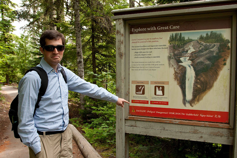 |
| Cody points out the warning sign |
After giving Cody a heads up about what he was in for, we packed the car for the long drive to Mt. St. Helens. In typical Northwest summer fashion, the day began cloudy and drizzly. Arrghh - not again! Was I ever going to get a sunny day to hike? The cloudy skies meant no views of Mt. St. Helens as we drove by.
 |
| They mean business |
At the trailhead, the moisture appeared to abate. Starting down the path, Cody and I took in the numerous warning signs that seemed to be posted everywhere. The National Volcanic Monument folks meant business! The graphics on this sign made me chuckle. However, I know slipping into a waterfall is not funny, and these signs did a good job of getting their message across.
 |
| Looking down the canyon near the trailhead |
This place has a fascinating history. The exposed basalt walls of the canyon are remnants of an ancient lava flow from a long-ago eruption. This flow ran through the valley over 3500 years ago, hardening into pillar-like formations. The Muddy River cut through the basalt, carving waterfall chutes and pillar-like lava towers. Then stream debris buried all these cool formations. They remained hidden until that fateful day in 1980 when Mt. St. Helens erupted.
 |
| Water-scoured lava |
The heat of the eruption instantly melted all of the glaciers on the mountain. Although St. Helens blew out in the opposite direction of this area (the explosion went north and this canyon is on the south side of MSH), the large amount of water from vaporized glaciers created a enormous mudflow, called a lahar. This lahar roared down the Muddy River, and washed Lava Canyon clean, exposing all the wonderful basalt formations once again.
 |
| Trail worn through the rocks |
The first half mile of the trail was very nice indeed. It alternated between a sturdy boardwalk and a wide, paved trail with many switchbacks. The monument even provided a couple of benches along the way for folks who might need a rest. We came upon an impressive wooden deck overlook (complete with more warning signs) that gave visitors a nice overview of the upper canyon.
 |
| Descending one of the many staircases |
But a half mile into the hike, things began to change. Our trail deteriorated to a slot worn between the rocks. There was an impressive view of the water-scoured chutes above the first set of waterfalls. The water was an interesting shade of gray-blue, no doubt due to glacial silt. It was oh so tempting to venture out onto the rocks to get a better view of things. But the monument folks had signs posted everywhere strongly warning of dire consequences. Even though things were dry, the basalt was still mighty slippery. I couldn't imagine what it must be like wet. Taking the safe route, I stayed put on the trail.
 |
| The trail passed by a large basalt outcrop |
Cody and I crossed a sturdy metal bridge over the roaring chasm. Our path then wandered through a thick, green forest, anchored on one side by a huge basalt monolith. We had occasional glimpses into the canyon below, the silty blue water churning frothy white.
 |
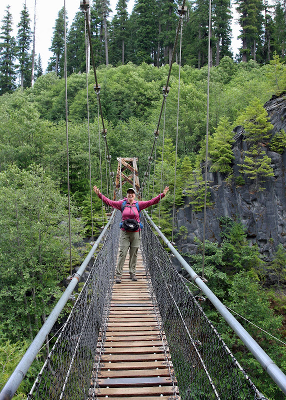
| Cool suspension bridge |
Then we came upon the bridge. The famous bridge. One of the trail's attractions is a high, springy suspension bridge. It's perched waayyy above the canyon's rocky chasm. And it moves as you walk across. Kind of unnerving.
 |
| Full bridge view |
Cody went across first. As he reached the bridge's center, I noticed he was hanging tightly onto the sides. I watched the deck and cables sway with his footsteps. Oh boy!
 |
| My turn! |
Then it was my turn to cross. Although standing on a moving bridge was a little spooky, it wasn't as bad as I thought. I even stopped mid-span and snapped a couple shots of the waterfall and creek above. What an adventure! It's not every trail that one gets an opportunity to walk over such a bridge. (I kinda felt like Indiana Jones!)
 |
| Tier of falls above the bridge |
After surviving our crossing, Cody and I continued on the trail, following it steeply downhill, deeper into the canyon. We passed a string of colossal waterfalls, all churning mightily. And our path's tread started edging closer and closer to the steep canyon walls. The trail in this area was crumbly loose rock, which made for dicey footing. These conditions made the next section mighty exciting.
 |
| Heading deeper into the canyon |
After a mile of descending and briefly traversing a boggy area, we came upon the ladder. In order to reach the canyon's very bottom, one must climb down a steep 40-foot metal ladder. Standing at the top, looking down, this ladder is intimidating. But it was attached solidly to the canyon's wall, and had beefy handrails. Once I swung myself onto it's rungs, I realized it was quite safe.
 |
| Beyond the basalt, the river broadens out |
About the time Cody and I reached the canyon bottom, the sun broke out from the clouds. The sunshine was most welcome, but the hot temps were not. Scrambling through the narrow canyon, the air seemed hot and stifling.
 |
| Barren riverbanks |
A prominent formation in this lower canyon, "The Ship" is a 100-foot-tall block of lava that rises up from the river. Cody found the sketchy scramble trail that took hikers to the monolith's very top. Of course, we had to go and check it out. It was quite a climb! I was huffing and puffing in the hot sunshine. But finally we arrived at the Ship's summit. It had a nice viewpoint of a three-tiered cascade tumbling down the canyon. A perfect lunch spot!
 |
| A sturdy bridge crossing |
After a nice lunch, Cody and I decided to continue downstream and take in more of this wonderful place. The trail weaved through dense forest, sometimes perched on the very edge of the canyon wall. Finally, we left the rocky canyon behind. The terrain flattened out and opened up into a broad plain of rock and flood debris. Remnants of the great lahar from the 1980 eruption, it was sobering to view. Another sturdy metal bridge traversed this rocky bank, and led hikers along the forested river's edge.
 |
| We even got to climb up a long ladder! |
Curious to see where it went, Cody and I decided to follow the trail for a little while longer. But after a half mile or so of thick forest and limited views, we turned around and headed back towards the canyon.
 |
| Cody going up |
Of course what goes down must come back up, and our return trip was a hot, tiring grind. All those steep downhills we slid down became long, sweaty climbs. The canyon walls prevented any air movement, so temps were stifling.
 |
| Wild strawberries along the trail |
Finally we reached the ladder. The climb up was much easier. Arriving at the top, we were greeted with a cool puff of air. It felt wonderful!
 |
| Stonecrop |
Trudging back towards the suspension bridge, I was moving slow enough to notice the abundant plant life that I'd missed on the trip down. Cody, having a botany degree, is a great person to hike with. He notices all of the vegetation, and is happy to point unusual things out to me. Cody spied a large patch of wild strawberries growing on the trail's edge. He also identified the pretty yellow plant climbing the canyon walls as stonecrop.
 |
| In places the trail was right on the cliff's edge |
We passed by the suspension bridge once again. A young child was running across the bridge, stopping to breathlessly tell us it was his 35th crossing (his mother said it was a good way to help him conquer his fears). Then we continued towards the trailhead, pausing to take in the view of the waterfalls continuing their journey through the rocky chutes. I noticed a bunch of people on top of a basalt pillar, one of the restricted areas. I guess some people think the signs don't apply to them! I was especially disturbed to see a man with a child on his back walking along this pillar. He strode right up to the cliff's very edge! No wonder there are fatalities here - some people do very stupid things! I now understood the reason for the large number of warning signs.
 |
| Roadside view of MSH and the lahar |
Heading for home, I had to make one last stop. Not far from the parking area, the road crosses a broad rock-strewn plain. This is the Muddy River and the barren plain was created from the 1980 lahar. It's a wide sterile area that even to this day, no vegetation has taken root. If you follow the river upstream there is usually an excellent view of Mt. St. Helens.
But today the mountain was shy, peeping in and out of the clouds. So no great volcano views for me this time!
What a great day. I love hiking the trails around Mt. St. Helens - they are like no other. The terrain and remnants of the eruption are fascinating. Although heard-pounding at times, the Lava Canyon Trail was a fun adventure. I now have a new favorite hike!
What a great hike except for that ladder. I wouldn't have been able to do that.
ReplyDeleteI am so glad that I found your blog. I love reading about trails and hiking where things are so different than the places I primarily hike. Except that it makes ME want to do those 100 Hikes!!
ReplyDeleteSuch a different hike. So interesting to see the effects of the St Helen's eruption - 30 years later. Nature is truely amazing.
ReplyDeleteOH WOW I love this this is a MUST do hike I think showing this to hubby hmmm maybe next summer but yes great shots thanks for sharing
ReplyDeletethanks for taking me along on this wonderful hike. I'm wondering how long it took to hike it in total? That's one of the best things about the great northwest - the hiking! the photos are fabulous, but I'm not sure I would have the courage to walk that suspension bridge. this was a delightful post. happy week to you Linda.
ReplyDeleteWhat a beautiful hike. Hubby and I love to hike and this year has been a real bummer. I had knee surgery last Weds. Because of it I have not been in too much of a hiking state. Just being out there in nature makes you feel so close to God. Love all of the scenery. Definately some ups and downs on this one.
ReplyDeleteHugs,
Jann
What a delightful hike! The day we were at Mt. St. Helens - we also couldn't see it. But I will never forget it for it was a special migration for these tiny frogs at the top of the mountain...thousands of them.
ReplyDeleteAnyhow... I am one to follow the signs and stay on the trail. My husband, well...he is not the same....ugh.
Linda, you had me at SUSPENSION BRIDGE! I'd cross that in a minute but my hubby wouldn't go near anything like that. You are killing me with all your wonderful hikes, in gorgeous locations.
ReplyDeleteGreat diversity on this hike. I'll have to check out that 100 Hikes book and see what the fuss is about! Loved your picture of the stonecrop, I'm a sucker for those plants that fight so hard to find a place to grow.
ReplyDeleteLinda, your blog looks like a lot of fun! Your photographs are wonderful, and I'm looking forward to following you on the trails like you've followed me. Happy trails! :)
ReplyDeleteWhat a fascinating post. I learned so much. A special experience to go hiking with your son.
ReplyDelete