Thursday, November 12, 2015

Climbing Lassen Peak

"Great things are done when men and mountains meet."  - William Blake


Lassen Peak devastated side

(**Ahem**  I'd like to amend the above quote:  Great things are also done when WOMEN and mountains meet.)

On the second day of my Lassen Volcanic National Park trip, I got the opportunity to achieve greatness by tackling the trek up Lassen Peak.


Golden fall meadow

After a night of sound sleep, I awoke to a beautiful clear morning.  Perfect mountain climbing weather!  Following the only highway that snaked through Lassen Park, I drunk in spectacular scenery while driving to the trailhead.  The winding road provided many wonderful viewpoints of this massive mountain. My arrival at Lassen Peak Trailhead was slightly delayed for a few (okay, many) photo stops along the way. 


Trailhead parking lot

The park road climbed relentlessly, from 5900 feet at Manzanita Lake, to 8200 feet at the Lassen Peak Trailhead.  As I parked my car in the huge lot, I realized this trailhead's elevation was almost equal to Mt. St. Helens' summit (MSH is at 8365 feet).


Beginning my climb

I was really high up!  Lingering snow patches still lined the parking lot edges and clung to the tops of nearby peaks.  Folks in the neighboring campsite had warned me that the upper reaches of Lassen Peak might be impassible due to snow and ice.  Feeling a little apprehensive about trail conditions, I fretted about being forced to turn around near the summit.  But I'd traveled too far not to give it a try.


Three mountains all in a row

The trek up Lassen Peak is short and steep, rising 2000 vertical feet in 2.5 miles.  The trail starts climbing right from the parking lot, and it didn't take long before I was huffing and puffing.  But this quick ascent meant rewards came quickly, and the stunning landscape began to spread out below me.


Lake Helen

Shimmering blue Lake Helen appeared below the mountain's rocky cliffs.


Faraway views to the east

And to the east, Juniper lake and surrounding hills emerged from the misty horizon.


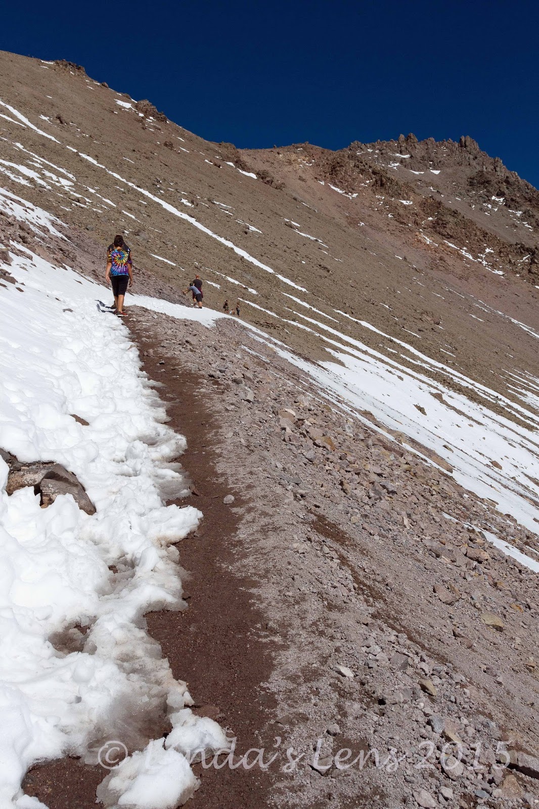
A bit of snow on the trail

About a third of the way up, snow began to partially block the trail.  At first, it was easy to bypass most of it.  But as I climbed, the white stuff began to get deeper, and covered more and more of the path.  Finally, I had to start wading through.  Luckily, the temperatures were warm enough to make the snow soft and slushy, so it was relatively easy to traverse.


Lake Helen is getting smaller...

I had my trekking poles for balance and stability, and tried to place my feet in the steps made by others.  When the steps weren't in the right places, I merely kicked some of my own.  Because I ski a lot, I'm used to traveling in snow, and hiking in it didn't bother me.  But I watched many others who were having a hard time navigating the snow patches.


Almost there!

For a steep climb this trail attracted crowds, even in mid-September.  I saw many people who didn't appear to have the necessary fitness to tackle such a strenuous hike.  Lots of families with young children, and quite a few older people were struggling in some of the steep, snowy places.  Quite a few folks weren't wearing proper footwear (I saw one lady in leather dress shoes!) or didn't appear to be carrying enough water (or any water).


Made it!

I'm not a very fast hiker, but I passed quite a few parties.  Although the high elevation slowed me some (well...that and photo taking), I was pleasantly surprised when the final summit pitch came into view.


Spectacular panoramas

Oh were the views glorious!  Northern California stretched out in all directions.  I could even see Mt. Shasta on the northern skyline.


Actual summit elevation is 10,457 feet - my gps is close

There were quite a few people on top.  One nice man offered to take my photo, and of course I took him up on it.

Victory photo

The actual true summit was a rocky pinnacle to the northeast of where most people stopped.  I saw a few hardy hikers scramble up its steep slopes, but decided to pass.  The ascent and altitude had tired me a bit, and I wanted to save energy for the trip down.


My little snowman

I ran into a nice family from - of all places - Oregon!  Their kids were having fun rolling snowballs, and this gave me the wild idea to make a tiny snowman.  I packed three fist-sized snowballs together and added a couple of rocks for eyes. 


Someone else liked my snowman too

My little snow-guy was a hit!  Not only did the kids like him, I caught this man snapping a photo as I was heading back down.


Heading back down

After climbing all morning, it was time for some sweet downhill!  I happily glided down the trail, casting sympathetic looks to all the people still grunting their way up.


Navigating the snow

Reaching the snowy patches, I found them quite trampled from the morning hiker traffic.  Footing had become uneven, and the snow packed into slippery icy patches.  That, combined with my downhill momentum made for some treacherous passages.  But I took things slow, used my trekking poles, and got through just fine.


Snow is starting to melt

The views coming down were just as grand.  I felt lucky to have such perfect weather - clear skies and moderate temperatures.  There's not much shade on this trail, and I'm sure it can be a hot trek in summer.


Close up look at the devastated area

At one point, the trail switchbacked around to give hikers a view of the "devastated area," the side of Lassen Peak where mudflows and hot gases traveled during the 1915 eruption, obliterating everything in their path.


Rock formation near the trailhead

My return trip took half as much time as my ascent.  It wasn't long before I was rounding the final switchback, the massive parking lot in full view.  Although it was now mid-afternoon, a constant stream of people still marched up the trail.  But I was most happy to be done.


Post hike relaxing at Lake Helen

I celebrated by munching potato chips on Lake Helen's shoreline, whose blue waters I'd admired during my climb and descent.  Lassen Peak reflected in the lake's surface, and I gazed at the summit with satisfaction.  An amazing hike, I was glad the weather and snow conditions had cooperated.  Yes indeed, great things had been accomplished today.

Next on my Lassen list was hiking into Bumpass Hell, a unique hydrothermal area.  Photos and story in my next post!


Sharing with:  Scenic Weekends and Our Beautiful World

Monday, November 9, 2015

Lassen National Park

In mid September, I embarked on a solo adventure.  I packed my car and headed south to Lassen Volcanic National Park.


Obligatory entrance sign selfie

A national park I'd wanted to visit for a long time, I finally decided this was the year, set a date and went.  My hubby didn't have enough vacation time, so I decided to go anyway - by myself. 


Marker #14 - the only place I could get cell service

Lassen is located in northern California, due east of the town of Redding.  It took a good 8 hours of driving until I finally pulled into the NW entrance, near Manzanita Lake.  Exhausted from an early start and long drive, I chose a site in the nearby spacious campground and set up my tent.


Manzanita Lake

But not quite ready to call it a day, I decided to check out this place I'd traveled so far to see.  First stop, find an area with cell reception to send my hubby a "made it safely" message.  After talking to a ranger at the entrance booth, I discovered the only place in the entire park with Verizon service was near "Marker 14" along the park road.  Luckily, it wasn't far from the campground, and yes, I did have service!


Lassen Peak

Then, I decided to stretch my legs with a hike around nearby Manzanita Lake.


Mountain reflections in Manzanita Lake

By then it was early evening, and the low-angle sunlight illuminated the lake's surface a lovely shade of blue.  Rounding the lake's western end, I was treated to picture-perfect reflections of Lassen Peak on it's still surface.


Crescent Crater

Everyone thinks Mt. St. Helens was the only volcano to erupt in the continental United States.  But Lassen Peak blew it's top one hundred years ago.  And until MSH came to life, Lassen had the distinction of being the only active volcano in the lower 48.


Lassen Peak wearing a dusting of snow

The west coast had suffered a bout of cold, wet weather earlier in the week.  However the day of my arrival I was greeted with nothing but sunshine.  An added bonus - the previous bad weather had capped Lassen Peak with a dusting of snow.


Perfect reflection!

I kept heading counterclockwise around Manzanita Lake, searching for the perfect photography spot.  The scenery and mountain views were outstanding, evening light illuminating nearby peaks perfectly.


Fall colors just beginning

Finally, the light beginning to fade, I retraced my steps to my favorite vantage point.  Lassen's reflection was nothing short of perfect here, accented by fall colors just beginning to turn.


One more reflection (just because!)

A final look at the mountain I was planning to climb tomorrow.


Friendly deer

Then, with the light fading fast, I made my way back to the campground.  En route, I got up close and personal with some of the park's permanent residents.


Deer at sunset

Yeah, the deer seemed very used to seeing people.  Worked well for this photographer!


Last evening light

I collapsed in my tent and slept soundly.  A good night's rest was necessary as the following day I planned to climb Lassen Peak.  Check back, my next post I'll tell you all about it!


Sharing with:  Through My Lens and Our World Tuesday. and Weekend Reflections

Saturday, November 7, 2015

Divine Colors in Indian Heaven

No matter when you plan to be on vacation, it always feels like you're missing out on something at home.

Such was the case during my early September South Dakota trip.  Cheeking the local hiking reports from my parent's computer, I stumbled across some recent photos of SW Washington's Indian Heaven Wilderness.


Fall huckleberry leaves

Those images blew me away.  Taken during a rainy, foggy day, the intensity and hue of the leaves were outstanding - deep reds and vibrant yellows.  Oh no, the fall colors were starting already!  And I was four states away.  Upon returning home, I knew exactly where I was going.


Roger contemplates a lake

Back home, the following Sunday morning, Roger and I pointed my Subaru towards the woods north and east of Carson, WA, destination Indian Heaven Wilderness.  Known for it's plentiful huckleberry fields in the late summer, this beautiful area of high lakes and alpine meadows also sports gorgeous displays of fall color.


Wilderness sign

Debating over which of the many paths into this wilderness to choose, I finally settled on the Thomas Lake trail because a.)  it was the closest trailhead and b.) it was the shortest distance (which hopefully meant more fall color bang for the buck).


Another lovely lake

Even though it's the closest, it's still a long drive to the Thomas Lake Trailhead.  After an hour and a half of winding Forest Service Roads, my hubby and I arrived at the parking area.  To our surprise, it was nearly full.  I squeezed my car in one of the very last spots.  Must be a lot of leaf peepers out today!


My hubby looking for fish

But.....hikers weren't the only folks here.  My hubby and I hadn't traveled far down the trail when we ran into a couple of men bow hunting for deer.  Apparently the season had just opened.


Yellow huckleberry leaves

Roger used to bow hunt, so he struck up a conversation with the men.  After leaving the first group of hunters, we ran into more.  We also passed a large number of overnight campers returning to the trailhead.  Due to it's relatively flat, short trails, the Indian Heaven Wilderness is a popular backpacking destination.


One the few green areas yet to turn

The nice thing about this trail was you didn't travel very far before arriving at the first of many lovely lakes.  Thomas and Dee Lakes were a mere 3/4 mile from the parking area.  Although shrunken in size from the hot, dry summer, both water bodies sported golden leaves around their shorelines.


Monet reflections

Our day's destination was Blue Lake, a 3-ish mile jaunt from the trailhead.  After the first lakes, we climbed a small hill and passed by Brader and Naha Lakes.  We stopped for a snack beside a tiny, unnamed lake with an impressive display of fall color lining its shores.  Bright reds and oranges reflected in the calm waters resembled a Monet painting.


Multicolored bushes

The color in its nearby woods wasn't too shabby either!


Colorful path

From the "Monet lake," Roger and I continued on, following the narrow, often deeply rutted path.  This area gets lots of hiker traffic, and all this love has rapidly deteriorated many trails.


Technicolor lake

Beyond our snack spot, the huckleberry bushes really started to ramp up their colors.  Deep reds, dazzling oranges, and bright yellows all lit up the forest in a brilliant display of autumn finery.  Instead of being stuck with monotones, it always amazes me that the same huckleberry leaves can turn into three different colors.


Golden lakeshore

Roger and I passed by several small lakes, rimmed by some of the most outstanding fall colors yet.  One was lined with blazing golden foliage.


More beautiful lakes

While another sported technicolor bands around its perimeter.


Tree reflections

I was enjoying myself so much photographing all the dazzling colors, that I didn't even realize we'd missed our trail at the junction.  I meandered behind Roger, taking frequent camera breaks, and it never dawned on me that it was taking an awful long time to reach Blue Lake.


Bright red huckleberry leaves

We trekked through an area where the trail was a faint line through a lovely meadow.  Again, I didn't think much of it (it had been a couple of years since I'd hiked here) until we arrived at Junction Lake.  Uh-oh.....this wasn't our destination.....we'd accidentally wandered 2 miles in the opposite direction!


Fall finery

Fortunately, Indian Heaven is easy to navigate.  I whipped out my map and determined we'd accidentally taken an old abandoned trail.  From our current location we could either retrace our steps, or take the Pacific Crest Trail (PCT) two miles and rendezvous with Blue Lake.  Although the PCT option would add a couple miles to our day, this loop sounded much more interesting.  We decided to go for it.


Yet another lovely trail

The PCT is a nice, wide, well graded trail.  After meandering through the rutted, sometimes faint, earlier path this seemed like a superhighway.  The fall colors weren't as good here, however, so Roger and I put our heads down and motored through the two miles between Junction and Blue Lake.


Marshy meadow

After that amazingly colorful abandoned trail, the PCT was sort of blase.  I didn't take a lot of photo stops here.  But that was probably a good thing, as it was approaching mid-afternoon and we now had extra miles to travel.


The PCT!

Finally Roger spotted a patch of blue between the trees.  Yahoo!  Blue Lake at last!  This lake got its name due to its distinctive aquamarine color.  I tried in vain to capture a bit of it on my memory card, but this was the best I could do.

From Blue Lake, it was an easy jaunt back to the trailhead.  We passed by the trail junction where we'd gone astray, and realized our mistake.  But I was now glad for the mishap.  The best colors of the day had been along that trail.


Blue Lake at last

My favorite way to end a hike is to indulge in beer and pizza at one of the many fabulous Gorge breweries.  And on our way home, that's exactly what Roger and I did.

With the high elevation fall colors now in full swing, it was time to change my focus from summer flowers to autumn glory.  And as you'll see in future posts, there's lots more to come!


Stats:  9 miles, 800 feet elevation gain.

Sharing with:  Our Beautiful World  and Weekend Reflections