Monday, September 14, 2015

Opal Creek

Tucked into the woods east of Salem, Oregon lies a magical place.  Ancient trees rise high to the sky, towering over clear, teal-blue waters.  Long strings of moss drape from branches,while huge ferns carpet the forest floor.  Exploration may yield hidden swimming holes, or remnants of a mining camp from bygone days.  After hosting many uses over the years, this area is now preserved as a wilderness area. 

The trail is an old road

It had been many years since I'd visited the Opal Creek Wilderness, and one Friday in late July I decided to pay a long-overdue visit.  Debbie, one of my long time hiking buddies, had recently retired and was able to join me.  I love having retired friends!


Abandoned lumber mill equipment in the woods

Sunny, hot weather was predicted that day - not much different from the weather we'd endured all summer long.  Hiking along a scenic creek seemed a perfect way to beat the heat.


Lovely aquamarine waters

Our trail began on an old road, now closed to auto traffic.  The road paralleled the super-scenic Little North Santiam River, crossing a side creek on a high bridge, and hugging several steep cliffs.  The forest here was filled with huge old fir and cedar trees.  Their thick branches shielded the sun's glare providing welcome shade.


Despite the heat, ferns are still growing

Gold was discovered here in the mid 1800s and a mining camp established in 1931 was named "Jawbone Flats."  An old lumber mill operated during the Depression, but quickly shut down after two of the lumber trucks fell off the narrow canyon road.


One of many large trees

Debbie and had traveled about two miles on the road when we came upon some of the old lumber milling equipment abandoned in the forest, slowly rusting away.  The most impressive find was a huge metal tank resting atop a brick foundation.  Moss crusted it's top and huge ferns grew from between cracks in the mortar.  Other smaller metal parts were scattered across the forest floor and a nearby rickety wooden building looked ready to collapse at any minute.


Enjoying the cool water

Debbie and I continued a short distance further until we came upon a bridge spanning the creek.  Here we got our first good look at the Little North Santiam's aqua-blue waters.  A family with several kids and a dog were splashing around in a picturesque swimming hole below.


Mother Nature's waterslide

It was at this bridge where Debbie and I left the road and dived into the woods.  A popular hike was to follow a forested trail to Opal Pool, and then return on the road, forming a nice loop.  That's what we planned to do today.


Peaceful lunch spot

The trail, although rooty and rough, was extremely scenic.  The forest was gorgeous, and we were never very far from the river's banks.  Debbie and I popped out creekside in a couple of places to enjoy the water's view.  In several locations, we came upon groups of young people sunning on the nearby rocks or playing in the cool waters, one group using a well-worn rock chute for a slide.


Gorgeous forest

High noon had come and gone, so Debbie and I discussed postponing lunch until we reached Opal Pool.  However, my tummy had different plans, and we ended up stopping early.  Taking advantage of a lovely creekside campsite, we enjoyed a peaceful lunch break and had the place to ourselves the entire time.


Loved the "hippy" signs

We found out later it had been smart to have lunch where we did.  We discovered Opal Pool is a very popular place - it was swarming with people.  There would've been no quiet lunch break if we'd stopped here.


Opal Pool water level was very low

Opal Pool was a large teal-blue pool that formed at the confluence of Opal Creek and the Little North Santiam River.  Over the years, rushing waters had worn the adjacent rocks down to form smooth bowls and channels.  The hot summer weather had dropped water levels drastically, and at first it was hard to determine the exact location of Opal Pool.


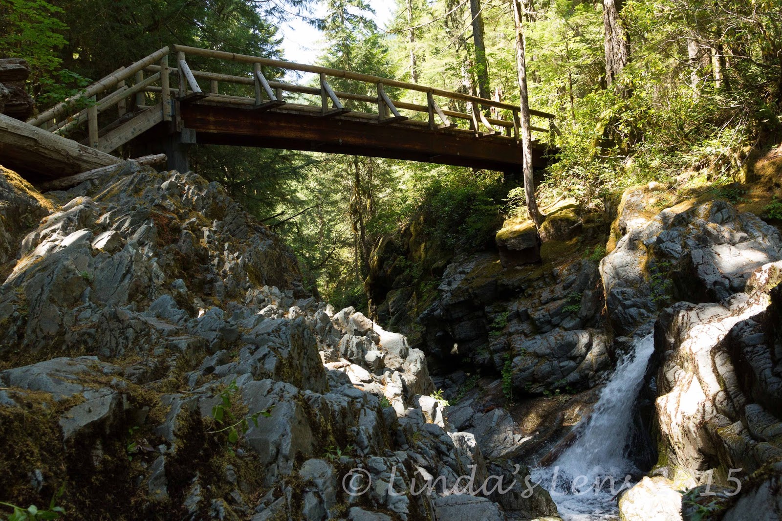
Tall bridge over the creek

Wanting to capture some images, I clambered down the steep river bank, and crossed a craggy rock slope to get up close and personal with the water.


Rushing water

I caught this miniature waterfall cascading through a notch in the rock.


Lovely, clear teal Opal Pool

And located a much-reduced Opal Pool.  It's waters were lovely indeed, a stunning shade of teal blue.  Although smaller in size, it was still gorgeous. 

The sunny skies didn't help with photography however.  Part of the water was in sun, while others in shade.  I tried my best to zero in on more intimate details, but I ended up with lots of "throw away" images.  Note to self - must return on a cloudy day!


Debbie watches from above

Debbie stayed above on the trail, watching her crazy friend clamber over all the slippery rocks (she's probably the smart one!)


Unique sign

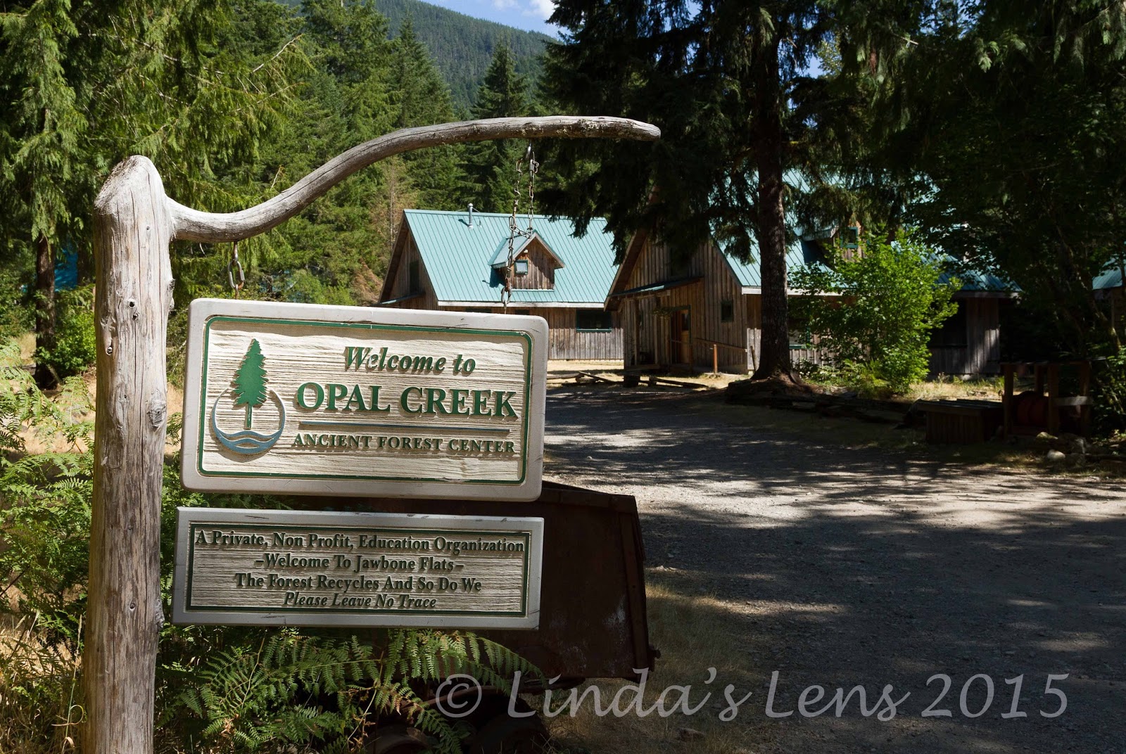
After Opal Pool, our trail climbed away from the creek until intersecting with the road again near the old mining town of Jawbone Flats.


A small settlement in the wilderness

From it's origins as a mining camp, Jawbone Flats has been preserved and now houses the Opal Creek Ancient Forest Center.  This area is now managed by Friends of Opal Creek, an organization that was formed in 1989 to gain protection of the Opal Creek watershed to study and enjoy.


One of Jawbone Flats' cabins

This area's plight was highlighted in the 1980s when Forest Service logging proposals generated intense controversy.  Thousands of people trekked into this area to view the endangered old growth groves.  A remnant of the great forests that once blanketed the Pacific Northwest, this was the largest contiguous area of low-elevation old growth left in Oregon.


Old abandoned car

Thanks to the work of the Friends of Opal Creek, this area won wilderness status in 1996, and is now protected.


Ancient fire engine

A walk through Jawbone Flats is like taking a step back in time.  Several old vehicles from the mining camp have been left in the forest, slowly rusting away, ferns and moss filling their bodies.  There's also a good collection of other mining equipment, including a few old ore cars, still connected together and sitting on a track.  Fascinating bits of history and also great photo subjects!


Jawbone Flats hydroelectric plant

A small staff lives here year-round, operating a tiny store and providing educational materials.  Besides a few private residences, the buildings include a dining hall, a lodge, and a couple of cabins that are rented out to visiting groups.


More quaint buildings

Debbie and I also passed a building that housed a small hydroelectric plant.  Water is piped down from higher elevations, and run through a turbine to generate electricity for the residences.  A very self-sustaining place!


Loved the unique touches

It was fun to walk through this unique, rustic old mining camp.  So nice to see these historic buildings preserved.  We stopped by the store, and Debbie struck up a conversation with the two young people manning the place, while I prowled around with my camera.


Lovely, clear waters of Opal Creek

Our trek out was entirely on the road - three long, hot miles.  The afternoon had heated up considerably, and not even thick vegetation could shield it all (but it was much better than nothing).  All the way out, we noticed a steady stream of people walking the opposite direction.  Many were wearing swimsuits, looking for a cool dip to escape the toasty temps.  Others were outfitted with large backpacks, intending to spend a weekend camping in the woods.  I was surprised by the large number of people heading into this wilderness area.  Arriving back at the trailhead, the large parking lot was nearly full.  I had no idea this place was so popular!


Following the road out

Still, I can understand why people flock to this beautiful area.  It's indeed a special place.  I'm glad this unique forest has been preserved for generations to come.  I just hope it doesn't get loved to death. 

A lovely place to be on a hot summer's day!

Stats:  7 miles, 300 feet elevation gain.


Sharing with:  Through My Lens and Our World Tuesday.

Wednesday, September 9, 2015

Vista Ridge

Are you ready to see some fireweed photos?  LOTS of fireweed photos??

Due to foot issues, I missed peak avalanche lily and beargrass bloom on the Vista Ridge Trail.  I'd heard it was spectacular, and was super bummed.  But then around mid-July I got wind that the fireweed was blooming thick and furious on this same trail.  Foot nearly healed, it was time for a visit!


Mt. Hood in morning light

The Vista Ridge Trail, on Mt Hood's northwest flank, takes lots of time and patience to reach.  Navigating a maze of forest service roads, it took nearly three hours before I arrived at it's trailhead.  I did get lost once, taking the wrong road at a fork.  But the silver lining to this misadventure was catching an amazing view of Hood illuminated by morning light.


Trailhead signage

Knowing it would be a long drive, I left my home super-early and arrived just as the sun was cresting over the hilltops.  Weather the day before had been a surprise bout of precipitation, drenching everything in raindrops.  The rising sun made these droplets glisten like diamonds.


Sunburst through the trees

In 2011, the Dollar Lake fire charred a huge area of Mt. Hood's north side.  Vista Ridge Trail was one of the casualties.  Although beginning my trek in a lush fir forest, barely a quarter mile later I came upon a bleak wasteland of ghostly gray trees.


First fireweed sighting

BUT.....the upside to this devastating fire was the abundance of wildflowers repopulating the burn area.  One of the first flowers to reestablish after a blaze is the lovely pink fireweed.  After entering the fire zone, it wasn't long before I got my first glimpse of these beauties rising up from the charred forest floor.


Lovely pink fireweed

A tall, slender wildflower, the pink blossoms of fireweed can reach up to five feet in height.


Fireweed carpeted the forest floor

The camera came out, and I immediately began shooting copious images of these pink beauties.  I hiked further up the trail, and came upon an even higher concentration of blooms.


Dew-dropped petals

Oh was it lovely!  The vivid pink petals really brightened up an otherwise gray, lifeless landscape.


A few views

Although the morning skies were still overcast from the previous night's weather, a few times the clouds parted just enough allow glimpses of the surrounding terrain.  The lack of vegetation on the trees opened up nice views of adjacent foothills and forests below.


Path through the flowers

As I ascended the trail, the concentration of fireweed became thicker and thicker.  In some places it nearly overtook the path.  A total "tiptoe through the wildflowers!"


The burned area coming back to life

I was so enthralled with the wildflower show, progress became glacially slow. I crept from one flower patch to the next, filling my memory card.  I'd never seen so much fireweed in bloom all at once!


"Hippy on a stick"

After a very slow 2 miles and 1200 feet of climbing, I arrived at a junction with the trail to Cairn Basin.  Although I'd left the burn zone and fireweed by then, some very nice specimens of Western Pasque Flower (aka "hippy on a stick") were blooming nearby.


Ghostly trees

Decision time.  I really, really wanted to hike down to Cairn Basin and return in a loop via the Timberline Trail.  However, this route necessitated double crossings of Ladd Creek, a fast-moving glacial stream.  After the previous day's rain, I was sure it would be running high.


Bright pink fireweed blooms!

After debating at the junction for a couple minutes, I decided to go for the loop.  I reasoned if I reached the first creek crossing and it was truly dangerous, I could always turn around and retrace my steps.


Monkeyflowers

The first part of this trail was a true delight.  I passed more large patches of fireweed, even more vividly colored than the previous batch.  I wandered through a gorgeous mountain meadow, already turning golden, and crossed a tiny creeklet lined by yellow monkeyflowers.


Mighty Ladd Creek

And then, I began to hear the sound of rushing water.  The trail seemed to disappear into the rocky banks of Ladd Creek, and it took a few tries before locating the crossing.


Foggy skies

A flimsy tree trunk had been placed across the Ladd's raging torrent.  This appeared to be what hikers were using to cross the creek.  I stared and stared at the log, trying to gather my courage to shimmy across.  The water was moving so fast, I knew one false move and I'd plummet into the strong current and be washed away.  From experience, I know most creek crossings look much worse than they really are.  However, something in my gut was telling me to turn around.


Huckleberries!

The fact that I was by myself finally swung the pendulum.  I reasoned that if I did attempt a crossing and fell into the creek, no one would be there to help.  It wasn't worth the risk.  Cairn Basin would have to wait for another day.


Timberline Trail

So I turned around and returned up the path I'd just galloped down, one mile uphill to the junction with Vista Ridge Trail.  And really, this trail was so beautiful the first time, I didn't mind passing through again.


Remains of the fire

As I started back down the Vista Ridge Trail, another surprise awaited.  Ripe huckleberries!  Bushes lined the trail, laden with tiny, sweet, purple fruit.  How had I missed this the first time?


Flowers brighten the burn area

After gorging on berries (slowing progress down once again) I continued downhill until reaching the fireweed zone once again.  Did I have enough photographs of the massive bloom yet?  I think you know the answer to that......


A splash of color

The overcast late morning light was nearly perfect for photography.  So of course I had to take advantage of it.  Forward progress ground to a halt.


Close up

Oh, I had so much fun trying to capture these unique wildflowers.  I came away with a bunch of amazing images (so hard to choose just a few for the blog).


Final view

Although I didn't complete the planned loop to Cairn Basin, I wasn't disappointed in the least.  Discovering such a large amount of fireweed at peak bloom was the highlight of this day. 

Stats:  8 miles, 1700 feet elevation gain.


Sharing with:  Through My Lens and Wednesday Around the World.

Thursday, September 3, 2015

Tail End of the Bloom

Mt. St. Helens is such a fascinating place.  Even 35 years after the mountain blew it's top, forever altering the landscape, recovery is just beginning.  Where else can you witness a drastically devastated area slowly returning to life?


MSH in the morning

A huge recovery indicator is the fabulous summer wildflower show that brightens the mountain's bleak plains every summer.  One of my favorite summer wildflower hikes, the Boundary Trail from Johnston Ridge Observatory to Harry's Ridge never fails to impress.  (Long time blog followers have no doubt seen a post or two about this ramble.)  Usually peak bloom occurs mid to late July.  But 2015 has been anything but a normal year.


Dry, dusty paintbrush

This summer, I begin to hear wildflower reports from MSH as early as mid June.  By the time my foot had healed enough to hike, nearly half of July had passed by.  If I wanted to catch the bloom, I needed to get my tail up the mountain pronto!


Curious chipmunk

So one Sunday morning in mid-July, I rose insanely early and withstood the long, 2-hour drive to MSH.  Blazing hot temperatures were predicted that day, and knowing this hike had little shade, I needed to take advantage of the cool morning.  Lack of crowds at that early hour would also be a plus.


Approaching Devils Elbow

Setting out from the trailhead, I realized I'd come just in time.  Most of the remaining Indian Paintbrush blooms were dry and dusty, and looked very much on their way out.  I was only able to locate a few scraggly plants of penstemon sporting flowers.  And the lupine, although more plentiful than the other varieties, were smaller in size and quantity.


Lupine in the morning light


At least I wasn't totally skunked.  There were still a few hardy blooms hanging around.  Enough to photograph anyway.


Crater close-up

I followed the dusty trail, marveling at the blue morning skies, and lovely early light on MSH's crater.  But the lack of snow on top was truly heartbreaking.  Another casualty of this unusual hot, dry summer.


MSH selfie

About two miles in, the trail follows a narrow peninsula that juts out over the blast area.  Nicknamed "Devils Elbow" a slender paths snakes across it's steep slope.  Traversing this ridge, the valley is a long ways down.  Not for the faint of heart!


Lupine lined trail


But I've hiked this trail many times, and the narrow tread doesn't bother me.  The views of MSH and the barren plains below are some of my favorites.


A glimpse of Spirit Lake

At the peninsula's furthest point, the mountain filled the skyline.  It looked close enough to reach out and touch.  Perfect place for photo ops!


Barren land

Nowhere is the eruption's damage more apparent.  When the mountain blew, this is the direction the debris cloud traveled, leveling everything it its path.  Wrinkled land directly below MSH is now scarred by many deep gullies, forever reminders of that fateful day.  And although vegetation is returning into these barren plains and valleys, it will be several decades before lush forests again cover the land. 


My trail markers

I was tempted to take the trail all the way to Harry's Ridge.  The scenery always beckons me to go just a little bit farther.  But I knew the longer I extended my hike, the more miles I'd have to travel for my return trip, and the later in the day I'd be hiking.  I had no desire to be out in the midday heat. 


Beauty amidst the devestation

So I turned around and headed back across Devils Elbow, stopping to capture a few more panoramic shots of the scoured Toutle River Valley.


A bee in mid-flight


I revisited my favorite lupine patch, and even caught a bee in mid-flight.  (Can you see him in this photo?)


Color spots

A typical Boundary trail scene.  Wood posts stuck in the ground that give hikers a visual guide to follow.  Small patches of orange and purple provide bright color spots in an otherwise dull landscape.


Last of the penstemon

But up close, the few blooming wildflowers stole the show.  One of the very few penstemon flowers I was able to find.  Usually so plentiful, in other years I've seen them carpet the hillsides purple.


Windy, dusty trail

Much of the return trail is slightly uphill, which isn't a lot of fun when you're tired and the day is beginning to heat up rapidly.  (And did I mention the lack of shade?)


Lovely yellow blooms

Traveling back towards my car, I was amazed by the number of people who were just beginning their hikes.  And many of them didn't appear to be carrying any water.


My fave MSH image

I reached the parking lot just after 10 am.  By then, the sun's rays were beating down, and temps were already in the 90s.  Although it was difficult to get up so early that morning, I was now thankful to be done.


Coldwater Lake pano (click to enlarge)

I ended my day with a quick visit to Coldwater Lake, a short distance down the road.  The mountain reflections on its calm waters were nothing short of fantastic.  Click on this image for a better view.

Glad I was able to get up to MSH for my annual visit before the flowers were all gone.  Although not as spectacular as past visits, at least I didn't totally miss this year's bloom.