
Sunday, October 13, 2013

Along the Wilson River

Here in Oregon, September is the best month weather-wise.  The hot temps have cooled down, the rain is yet to come, and fall colors start peeping out from trees.  I made plans to go hiking with a friend on a mid-September Sunday.  But, alas, by Saturday the forecast predicted rain, and my friend ended up canceling.  Not wanting to sit around the house all day, I decided rain or no rain, I was still going hiking.


Lone fisherman on the Wilson River

Tired of driving across town to access the Gorge or Mt. Hood, I instead looked westward.  The Coast Range, between Portland and the ocean, has some terrific trails.  And it's a short drive from home.  But for some reason I've never fully explored this area.  I decided today that would change.


Pretty vine maple

Since the Coast Range catches all the precip coming in from the ocean first, during rainy days it's a fairly wet place.  I knew I was probably crazy to go hiking there on a day with rain in the forecast.  But I packed a bunch of raingear, some towels, and decided to make the best of it.  Also, against my better judgement, I loaded up the dog.


Inviting bridge crossing

After a little internet research I settled on the Wilson River Trail.  The Wilson River, flowing out of the coast range into the ocean, boasts a trail paralleling 20.6 miles of its forested banks.  Accessed by several trailheads, hiking options abound.  The stretch from Jones Creek to Bridge Creek Falls, a total of 7 round-trip miles, was my final choice.


Scattering of moss and fall color

Although I left my house during a heavy shower, by time I drove into the trailhead, things were dry.  I suited up with raincoat and gaiters, only to shed them a half mile down the trail.


Lovely river reflections

The Wilson River in this area runs through the Tillamook State Forest.  Not only for hiking, this wooded area supports a variety of outdoor recreation uses.  Not far from the trailhead parking area was a place to stage off road vehicles, and corresponding trails for this purpose.  I spotted a few people fishing from the Wilson river's banks.  And mountain biking is also allowed on the hiking trails.


Leaf color is just getting started


So, let's just say that the forest along the Wilson River is not exactly pristine wilderness.  But, as I discovered upon the first half mile, it sure is beautiful.


Bear takes a water break

A quarter mile from the Jones Creek Trailhead, a huge suspension bridge takes visitors across the Wilson to the Tillamook Forest Center.  An interpretive and educational place, this center showcases the area's logging legacy and provides information about the infamous Tillamook Burn (A huge series of forest fires that struck this area over the 1930s).  Because I  had my dog with me, I skipped a visit for today and stayed on the opposite shore.
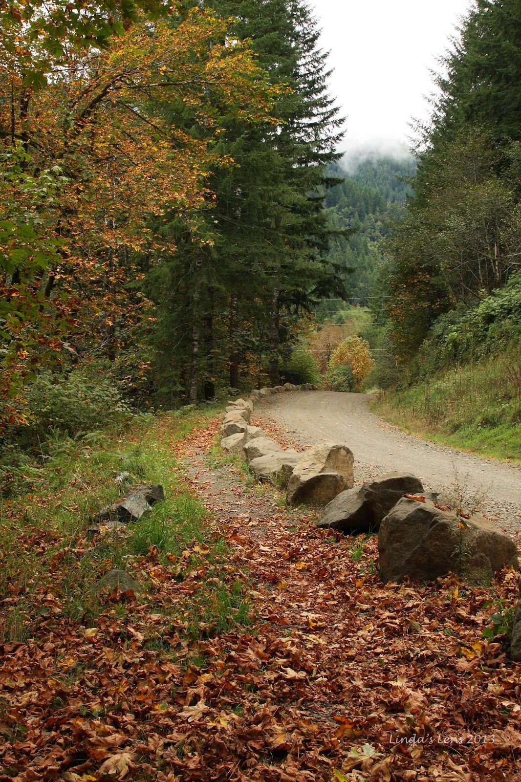


Our trail paralleled an old road

Although the majority of leaves were still in various stages of green, there was just enough yellow and orange to provide nice accents.  And make some great photos.


This way to Wilson Falls

I trekked through areas of dense forest with thick vegetation below.  Huge clumps of moss draped from some of the tree branches.  Although the river was always in view, only a few steep trails led to its banks.  Bear and I made a couple trips to shore, to check things out (and to give Bear a chance to drink).


Bear in a maze of leaves


About halfway to our turnaround at Bridge Creek Falls, the trail began to veer away from the river, and climbed over a couple of ridges.  Then it would dive down to cross small side creeks, spanned by one-log bridges.  I'd expected a flat trail, so these climbs were a surprise. 


One of many log bridges

Finally Bear and I came to a side trail that was supposed to lead to Bridge Creek Falls.  But I got waylaid by a scenic bend in the river.  Next to the bend was a deep pool, that appeared to be used as a summer swimming hole.  A downed tree had a rope swing attached to its end that I assumed was used for this purpose.  Ready for a break, I took a seat on the adjacent rocks and snacked on some apples and a cliff bar.


An old swimming hole

My gps showed we'd already traveled more than 3.5 miles.  I decided to bag the additional trek to Bridge Creek Falls and head back.  So Bear and I began to backtrack our route, hoping to beat any rain.  We came upon one of the single-log bridges.  Bear started across, and I took out my camera to capture him on the bridge.  I called out for Bear to stop and tried to get him to turn his head around.  But instead poor Bear tried to turn his whole body around, and in the process, slipped and tumbled into the creek below.


Tunnel of green

I panicked.  Rushing to the side of the depression, I arrived just as Bear scrambled up the bank.  He'd fallen down a drop of at least six feet onto rocks below.  Anxiously, I felt his legs and feet for any sign of broken bones.  Bear didn't wince at all.  In fact, the only injury appeared to be a couple of small gashes on his face.  Bear had weathered this slip just fine.

My dog's always been a very sure-footed pup, so having him fall like that greatly surprised me.  But at nearly 12 years old, Bear has been slowing down.  And this stumble confirmed to me just how much he's declined.


One last flower

So Bear and I continued back to the trailhead, him moving much slower than before, and I watching him like a hawk for any sign of limping.  We passed a large family with tons of kids scattered up and down the path, and a dad trudging along behind smoking a cigarette (!!!!! in a forest!!!)


Beautiful river view

We made it back to the car with no further incidents.  Although very tired, Bear seemed to have weathered  his fall just fine.  As I loaded my backpack into the car, I realized throughout the entire hike not a drop of rain had fallen.  When I arrived back in town, my hubby complained it had rained off and on most of the afternoon.  Guess I picked the right place to hike today!

The Wilson River, although very much touched by man, was still a lovely place to hike, and only a 40 minute drive from my front door.  I have a feeling I'll be back soon, to explore more of its trails.


Sharing with:  Tuesday Muse.

Tuesday, October 8, 2013

A Ski Area in Summer

Poor Mt. Hood.....by early September she looked so gray and bare.  Snow-riding season was still nearly three months away.  But I had plans to visit my favorite ski area anyway.  Only this time I'd be on foot.


Mt. Hood is looking barren

Once the snow goes away, most ski areas turn into ugly barren places.  But not my home hill, Mt. Hood Meadows.  In summer, its ski runs turn into a wildflower paradise.  The Timberline Trail, which circles Mt. Hood, passes through the area's boundaries.  Connecting this trail with a couple other adjacent paths makes a wonderful 10-mile loop.  And late summer is a great time to visit.


The best butt-burl ever!

One sunny Sunday in early September I got a yearning to check out Mt Hood Meadows' side of the mountain.  My friend Katie was more than happy to join me for this latest adventure.

Parking at the Elk Meadows Trailhead, near the Hood River Meadows parking lot, our first leg of the journey was the Umbrella Falls Trail.  A short two-mile ramble took us through lush green meadows.  The adjacent forests were full of interesting trees, many sporting funny shaped burls.  The wide variety of burls kept my camera clicking.  Then I spotted one that was the most realistic replica of a butt crack I've ever seen!


Umbrella Falls

Leaving the butt-tree, Katie came upon lovely Umbrella Falls.  A hidden gem, this delicate stair-stepped cascade isn't as well-known as its Columbia River Gorge cousins.


Cascade close-up

But it's beauty rivals any waterfall in the Gorge.  While Katie took a snack break, I dug out my camera for a photo session.  Not having my tripod, I had to improvise by propping the camera on my backpack and utilizing its self-timer.  I was pleasantly surprised with the results.


View towards Mt. Hood Meadows parking lot

Leaving Umbrella Falls, Katie and I followed a continuation of the trail.  It led us past a nice clearing with great views of Mt. Hood.  The only problem - it was right next to Mt. Hood Meadow's main parking lot.  I tried my hardest to crop the ski area buildings out of my photos but this was the best I could do.


Beautiful mountain meadow

Leaving Meadow's access road, our path wound through a mixture of fir forests and open meadows.  Each opening offered yet another spectacular view of my favorite mountain.


More Hippy-on-a-stick

I was hoping to see a few leftover wildflowers, but sadly the main bloom was well past.  Happily, one meadow did have a small patch of "hippy on a stick" stragglers for my camera's enjoyment.


Looking down the Easy Rider chair

After climbing for nearly a mile and a half, our path intersected with the Timberline Trail.  Now into Mt. Hood Meadows' boundary, the scenery improved considerably.  The cleared ski slopes sported lush green vegetation.


Tons of color in this magic meadow

And lots of colorful plants and bushes.


Bright red berries on this bush

We hiked down through a small gully with a cute rushing stream at the bottom.  Filled in with snow during the winter, it was cool to see what was underneath all that white.  Tall bushes showed off bright red berries, giving the place a splash of color.


Still a few wildflowers

Although the flowers were mostly withered up and dead, I did come across one small field of asters still going strong.


And even a butterfly!

I even managed to catch a butterfly for a split second when it landed in the flower patch.


Dried, golden beargrass stems under the Express lift

The parade of scenery continued.  Our trail cut across the middle of ski slopes and snaked under chairlifts.  I had a great time identifying all my favorite ski runs.  Things looked so different without six feet of snow.


Another lovely meadow

Having skied at Meadows for many, many years, I know the place like the back of my hand and impressed Katie with my navigational knowledge.  From the bunny slopes on the west side, we traversed Express and Shooting Star lift areas.  I named off every run as we passed them by.

Heading northeast across the ski area boundary, there was just one final slope to cross - Heather Canyon.


Looking for a crossing point

Heather Canyon is a steep, experts-only area.  Cloaked in winter white, it's a wild, beautiful place.  But in summer, not so much.  It's barren, gray rocky slopes look like a moonscape.  Over the years, many avalanches have roared down this canyon - not exactly conducive to supporting vegetation and trees.


Climbing out of Heather Canyon

It was a long, steep trek down the west face of Heather Canyon.  In the canyon's very bottom, ran swift, chocolate-brown Clark Creek.  By the time we arrived, it was mid-afternoon, and the day's snowmelt had swollen the creek into a raging torrent.  No bridge existed here.  To get across hikers had two choices - wade or rock-hop.


Looking back up Heather Canyon

Katie and I traveled up and down the bank, scouting for a good place to cross.  Sometimes other hikers will lay logs down to form a makeshift bridge, or pile cairns to indicate a safe crossing route.  But today we found none of these.  Finally, I spied a narrower spot that appeared to have some well-spaced rocks.  Although it looked scary to hop across, I took a deep breath and made my move.  As I've learned, most creeks look way more difficult to traverse than they really are.  Both Katie and I leapt across no problem.


I thought we'd never find this trail

Katie and I celebrated our successful conquest of Clark Creek with a snack break.  Then we shouldered our packs for the steep climb up the canyon's east side.  The trail rose up and up and up.  I though we'd never see level ground again.  At the very top, we kept a sharp eye out for a junction with the Newton Creek Trail, the final leg of our loop.


Silver ghost trees

The Newton Creek trail followed this creek down the west side of Newton Canyon.  Snaking along the ridgetop, spectacular views abound.  I could see across the valley to Gnarl Ridge, on the opposite side.  Forested hills spread out in all directions.  And the very top was lined with a parade of ancient silver snags.  Good photo subjects!


Hiking along a ridgeline gives marvelous views

After such a long uphill slog, traveling downhill was a welcome change.  Our path charged steeply down, following the very top of Newton Canyon.  As we ascended, the views behind us kept getting better and better.  Mt. Hood appeared once again, anchoring the canyon's upper reaches.


Looking back up Newton Canyon

As we approached our last junction with the Elk Meadows Trail, the rocky ridgetop began transitioning into forest, and the tall steep slopes above Newton Creek began to flatten.  Then bursting out into a small clearing not 20 yards in front me was an enormous elk!  I immediately stopped in my tracks and gasped a garbled "ohhhhh" to Katie.  The elk stood there for a long moment eyeing us.  It was then I remembered my camera readily available in the fanny pack around my waist.  Fumbling quickly to get it out, my motions spooked our wild friend.  Just as I brought the camera to my face, the elk shot off into the forest.  And - surprise - right behind her, a second elk came bounding up the creek's steep slope and quickly followed her friend into the woods.


Katie and I celebrate a safe crossing of Clark Creek

Katie and stood open-mouthed.  In all my years hiking, this was the closet wildlife encounter ever.  We both agreed seeing those elk so close was the highlight of our day.  A perfect end to an amazing hike!

We finished our day's journey hot and tired, but with huge smiles.  Who would've thought trekking through a ski area in summer could be so beautiful, interesting, and exciting?


Sharing with:  Weekly Top Shot.

Saturday, October 5, 2013

Gold

It's starting......

The leaves here are just beginning their annual fall change.  I went for a short autumn color reconnaissance hike on Friday.  Although the main show in the Gorge is still a few weeks away, I did find a few nice golden leaves brightening up the forest.


Trying to get back in the swing of the 52 Photos Project, I noticed the week's meme is Gold.  This lovely little leaf, backlit by the sun became a perfect subject. 

I'm looking forward to prowling the mountains and Gorge and capturing more wonderful fall hues yet to come.  Stay tuned!

In the meantime, check out the 52 Photos Project for more gorgeous autumn scenes.


Thursday, October 3, 2013

Rushmore, Tunnels, and Buffalo

Before I start today's story, I'd like to tell you about my recent blogger meet up.  Susan, who blogs over at Travel Bug, was visiting family here in Portland.  I commented on a post she wrote about the Columbia River Gorge (such a wonderful place!) and in her reply, Susan invited me to lunch.

This past Monday, Susan drove all the way in to downtown Portland (in pouring rain, no less) to have lunch with me.  We had a wonderful chat, and I returned to work with a big smile on my face.  I trade comments with many online friends, and it was truly wonderful to meet one of my fellow blogging sisters live and in person.  Susan, next time you're in Portland look me up, and let's go hiking!


Mt. Rushmore drive-by

OK, now set your way-back machine for mid-August.  I'm still playing catch up from my vacation to South Dakota.

One of my favorite day trips in the Black Hills is the Iron Mountain Road and Needles Highway loops.  Way too much time had passed since I'd last driven these roads, so I blocked out an afternoon and declared we were going!  My sister volunteered to drive, and I convinced my hubby and son to come along for the ride.


The four Presidents, up close and personal

When you're visiting the Black Hills, there is one place you just have to go - Mt. Rushmore, of course!  However, the place has changed a lot from my childhood visits.  There's now a ginormous parking garage that charges a fortune to park.  Not wanting to deal with this, we instead chose a roadside viewing of the famous faces.


There's a surprise on the other side of this tunnel

Besides, there are other, cooler ways to see the monument.  Turning onto the Iron Mountain Road, the first thing one notices is there's a lot of tunnels.   And this one had a surprise on the other side.....


Ta-da!  Mt. Rushmore peekabo

Yep - there's those four presidents staring through the tunnel.  While stopped taking photos, a family from Texas pulled up and asked what "we-all" were looking at.  When they saw this view at the other end, the Texans were amazed.  Cameras came out, and I think they even beat me in the number of photos taken.


Yahoo!  Another tunnel!

Tunnels are awesome!  And in the roads of the Black Hills, tunnels rule.  Here's another great example of one found on the Iron Mountain Road.

Most of these tunnels have only one lane, and signs direct motorists to sound their horn before passing through, alerting any vehicles on the other side.  Growing up, I thought that's what you did before driving through any tunnel.  But after living other places I've come to realize it's just a South Dakota thing.


Underside of a Pigtail bridge

Besides cool tunnels, this road is also known for it's unique "Pigtail" bridges.  These wooden structures, stacked on top of one another, create some of the road's tight curves.  This entire highway was purposely designed to be driven slowly, allowing motorists to take in and fully appreciate the natural beauty of the land.  For more information about the Iron Mountain Road, check out this website.


Lovely green Black Hills forest

I couldn't get over how green the Black Hills were for the middle of August.  Usually everything is dry and brown.  It's been a wet spring and summer here, and the forests looked absolutely gorgeous.


Roadside buffalo sighting

Our curvy, scenery-packed road wound down through the granite hills, until we reached the grassy plains of Custer State Park.  Driving towards the park entrance, our vehicle was stopped by a line of traffic on the road.  Craning our necks to see ahead, my sis spotted the holdup.  Buffalo!


Custer State Park buffalo herd

A huge buffalo herd was roaming right next to the road.  And, of course, a few inconsiderate people had stopped their vehicles smack dab in the middle of the asphalt lanes to take photos.  We sat in the buffalo-jam for at least 15 minutes before the cars started moving again.  Ugh - tourists!

Although, when we finally were able to cruise by the massive beasts, I could kind of see why people had stopped.  These animals were magnificent!  I quickly shot a bunch of photos while my sis drove as slowly as she could.


The State Game Lodge in Custer State Park

We drove into Custer State Park proper, and saw a sign for the State Game Lodge.  It had been a very long time since I'd visited here, so a stop was in order.


Famous as the summer white house for President Coolidge

The State Game Lodge is part of the Custer State Park Resort.  This stunning stone and wood building was constructed in 1920, and is listed in the National Register of Historic Places.  President Calvin Coolidge used this as his "Summer White House" in 1927.


My sis poses on the steps

Such a pretty place!  Nestled under ponderosa pines, the grounds were landscaped beautifully.  A huge rock staircase and porch circled the outer walls.  We all went inside and checked out the dining hall and gift shop.  And my sister and I snuck upstairs to take a peep at the rooms.


Annddd......another tunnel!

Then, back on the road again, for more - you guessed it - tunnels!  We saw a sign for the Needles Highway, and since it was on our way home, decided to take the scenic route once again.


The Needles

"The Needles" are the name of a collection of granite spires found in the Black Hills.  These narrow granite blocks rise up from the surrounding landscape in many interesting forms.  The Needles Highway is another windy, narrow road that was built for scenery, not speed.


Narrow passage on the Needle Eye tunnel

And, of course, there are more tunnels.  The granddaddy of tunnels, is the narrow passage at a rock formation known at the "Needles Eye."  The road threads through the middle of two sheer granite cliffs.  Only wide enough for one lane of traffic, it's especially interesting to see a large tour bus inch through.  (They do this several times a day!)


More cool granite spires

We began to run short on time, and my sis needed to get home and pick up one of her daughters.  So I only got a couple of short stops in the Needles to grab a photo or two.  Otherwise, I hung out the car window, snapping away with my camera.


This road winds right through the rocks

But I managed to get a few cool shots.  I especially like the perspective on this one.  It's not every road that you can get so close to large granite formations.


Sylvan Lake

The Needles Highway ends at beautiful Sylvan Lake in Custer State Park.  One of my favorite places in the Black Hills.  But there was no time to stop and explore today.  I was able to get a few final shots before heading home.

I'm happy I was able to do a little sightseeing, even if it was just for short while.  The Black Hills are an amazing place, full of interesting things.  Where else can you see a famous monument, wild buffalo, amazing rock formations, and of course tunnels, all in an afternoon's drive?


Sharing with:  Weekly Top Shot.