As many of you know, I love to hike the trails around Mt. St. Helens National Volcanic Monument. Over the years, I've trod a good number of them. But, believe it or not, there are still a few paths in the monument I've yet to set foot on. One is the Truman Trail.
 |
| Memorial at Johnston Ridge Observatory |
I don't have a good excuse as to why I've never completed this trail. Unlike many of the paths in the MSH Volcanic Monument, it's easily accessible from the Boundary Trail, which I've hiked at least once a year for many, many years. Every time I passed the sign for the Truman Trail, I was either intent on climbing Harry's Ridge or making my yearly trek up to Coldwater Peak. However, signs to unknown trails have a way of intriguing me. I always wondered exactly where this trail went and what the terrain was like beyond the sign.
 |
| Names of those who perished in the 1980 eruption |
This year in late May I decided to find out. Consulting a map, I discovered the Truman Trail takes one across the heart of the MSH eruption zone, passing through an area known as the "Pumice Plain." After 4 miles, it intersects with the round-the-mountain Loowit Trail. Another mile on the Loowit takes one to Loowit Falls, which I've visited in prior hikes, accessing it from a different direction via the trailhead at Windy Ridge.
 |
| Mountain goat below the trail |
Actually I had two goals for this day. The first, of course, to explore the Truman Trail, but my second was to hopefully see some mountain goats. I'd heard several goats had recently been spotted on the cliffs below Johnston Ridge Observatory. In preparation for hopeful wildlife sightings I packed my 800 mm zoom lens. Although heavy, I reasoned if I happened to capture a mountain goat or elk, it would be well worth the extra weight.
 |
| Curious mountain goats |
It's a long 2-hour drive to Johnston Ridge Observatory, the day's starting point, which necessitated an early departure. But the excitement of exploring a new trail kept me motivated as I traveled north, then east. After parking and shouldering my backpack, I first walked up to the shuttered Observatory (closed for a second year due to COVID) and enjoyed the overlook free of crowds - the reward for early risers. I then took a paved path from the Observatory to the beginning of the Boundary Trail. Normally when hiking the Boundary Trail I'll access it via another path direct from the parking lot, but today I thought I'd try something new. I discovered an impressive monument sited on a high point bearing the names of everyone who perished in the 1980 eruption.
 |
| Beginning of the Truman Trail |
From the junction with the Boundary Trail, I had a 2.5 mile trek ahead of me to reach the Truman Trail. Ready to put my head down and march through this very familiar section I became instantly waylaid upon spotting some white dots on a ridge below the trail. The dots appeared to be moving. Could it be mountain goats? Quickly switching camera lenses confirmed my suspicion.
 |
| Great views of MSH |
Goal number one met and I hadn't even traveled a half mile! There was a small herd of about a dozen mountain goats wandering the slope below the Observatory. One mother goat with a baby was sitting about halfway down the slope, barely visible to the naked eye. Good thing I had my zoom lens or I would've totally missed them. I took copious images of the goats, and even with the 800 mm zoom, they were tiny in my photos. (The second goat picture I posted here has been heavily cropped.) A few hikers passed by and I had to point the mountain goats out to all of them - the critters were so far away, they were easy to miss.
 |
| The lava dome inside the crater was visible |
My extended goat photo session ate up valuable hiking time, and after a good 45 minutes I finally returned my big lens to the backpack and put the hammer down. Since I'd hiked the first 2.5 miles of the Boundary Trail countless times (and there were no wildflowers blooming yet), I covered the distance quickly. Soon the familiar junction with the Truman Trail came into view. But today, instead of passing by, I was finally going to turn down the Truman Trail!
 |
| Looks like this path is leading right into the crater |
Right away, the Truman Trail dropped steeply downhill. The ridge I was descending was known as the Spillover. When MSH blew apart, a debris landslide swept northward and crested this low ridge, spilling ash and rubble into the adjacent drainage area of South Coldwater Creek. Once desolate, this area was now full of tall alder and cottonwood trees higher than my head. I enjoyed the shade while I could, knowing once I reached the Pumice Plain, there would be none.
 |
| One of the tiny, odd-colored ponds near the pumice plain |
After about a mile of downhill, the path flattened out and the vegetation thinned. I was now entering the area known as the Pumice Plain. Made up of pyroclastic flows from the eruption, this material dammed the Toutle River, which had been the outlet for Spirit Lake. Without an outflow, the Army Corp of Engineers was concerned that water in Spirit Lake might rise up so high that it would breach this debris area and cause catastrophic flooding to downstream communities. To fix this issue, the Corp build an 1.6 mile tunnel that diverted water from Spirit Lake to South Coldwater Creek. Once completed, this tunnel was able to successfully regulate water levels on the lake.
 |
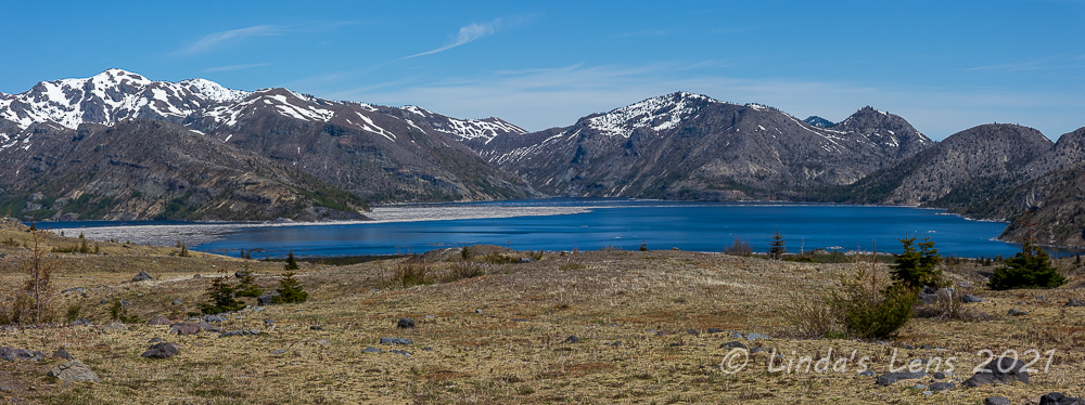
| Pumice plain looking towards Spirit Lake |
The flat area of the Pumice Plain that I was now traversing was part of an old road bed, built in 1982 for the tunnel construction. Left in place, this abandoned roadbed currently hosts several research sites monitoring the volcano's recovery. I passed by a couple of weirdly colored ponds below mounds of eruption debris. I later read that the debris avalanche here is as much as 200 meters deep!
 |
| One of the rock-strewn gullies I had to cross |
Although flat and desolate, the Pumice Plain's lack of vegetation provided top-notch views of the surrounding scenery. Spirit Lake's southwest shoreline ringed by the peaks of the Mt. Margaret backcountry spread out to my left. The barren hills of Windy Ridge rose to the east. And of course MSH herself was always front and center, giving spectacular views of the crater and lava dome inside. Lots of photos may have been taken....
 |
| Marker post |
My trail passed through a gully full of gushing springs and willow trees. This part was a little tricky, having to navigate muddy water crossings and crash through brush. But I did spot lots of birds darting through the trees. I was happy for the wildlife sightings as this was the first since the mountain goats. I'd hoped to spot elk along the Truman Trail, but although I saw signs, there were none to be found.
 |
| Willow Springs trail junction |
Past the springs, I climbed a ridge to a high point that gave wonderful views back towards Spirit Lake. A few hardy Indian paintbrush flowers were just beginning to bloom. I suspected the wildflowers here would put on a good show in another month. Just a bit farther and I ran into the junction with the Willow Springs Trail. This was good news as it was now only 3/4 mile left to go before the intersection with the Loowit Trail!
 |
| Spirit Lake view from the junction, looking towards Mt Margaret backcountry |
I continued on through a rock-strewn wasteland, cut up by gullies. A few hardy conifer trees struggled to grow in the rocky plain. There was absolutely no shade here and the midday sun began to beat down upon me. Although the day had started with cool temperatures, it was now getting mighty warm.
 |
| Loowit Falls visible in the middle of this photo |
I noticed Loowit Falls flowing from a crevice below the crater, still far away. Although I'd considered hiking all the way to the falls, it would add 2 miles round-trip to the day's already long distance (I ended up traveling 12.5 miles that day). So I decided today's goal would be to reach the junction with the Loowit Trail (which is MSH's round-the-mountain trail).
 |
| Hardy trees growing in the rocks |
As I approached the Loowit junction, the wind began to kick up. Not a problem for me, it provided cooling relief from the warm temperatures. Then I noticed some unusual wispy clouds forming over MSH's summit.
 |
| Rocky trail |
The clouds looked like dancing angels or some sort of ghost spirits.
 |
| I noticed some really cool clouds above the mountain |
You know me, of course I had to take a bunch of photos of them!
 |
| Wispy, ghost-like clouds |
So enjoy my photo dump. :)
 |
| These clouds look like dancing angels |
Despite the wispy interruption, I did finally put the camera away and continue my trek to the Loowit Trail junction.
 |
| Cloud close-up |
The junction sign was a welcome sight! I was surprised to see one of the two signs laying on the ground. Not sure if it got knocked over during the winter - hopefully no person did that. After a quick photo by the remaining upright sign, I found a partially sheltered rock to rest and have lunch.
 |
| Junction with the Loowit Trail, my turn-around point |
All morning once I'd set foot on the Truman Trail, I hadn't seen another person. My human interactions began just as I was packing up my lunch and getting ready to retrace my steps back. Two men came trudging up the last rocky slope towards the junction. After seeing no one for a couple of hours it was kind of a shock.
 |
| Early blooming dwarf lupine |
But on my return trip, I encountered group after group of people. Near the Willow Springs trail junction I ran into a man carrying a huge jug of water and two backpacks. Two women were passing me at the same time, and the man stopped all three of us to chat. He was working for a conservation group that studied the MSH area and he wanted to make us aware of an upcoming project proposed by the Forest Service.
 |
| Spirit Lake pano, looking north |
According to the Forest Service and Corp of Engineers, the tunnel used to drain Spirit Lake urgently needed repairs. Ground movement had constricted the tunnel in some places, reducing it's capacity. The Forest Service was proposing to reopen the original construction road to move equipment into the area for the repair work.
 |
| Empty desolation |
The issue this man had with the Forest Service's plan was that the road construction would disturb research plots that had been in use for several decades. He was also concerned the construction could introduce invasive plant species to the recovering monument, undoing research, and also invite illegal use of this protected area. His conservation group, along with many scientists and other environmental groups had filed a lawsuit to temporarily halt construction. The man said he wasn't against the work - he understood the need to fix the failing tunnel. The lawsuit sought to review the construction methods to see if a better, more environmentally friendly approach could be found.
 |
| Early season Indian paintbrush |
After tearing myself away from this very chatty man, I pondered his words as I trekked back across the wide, empty Pumice Plain. It would be a shame to have this unique area torn up by construction and closed to hikers for several years (especially since I'd finally visited this trail). Although I'm sure more environmentally sensitive construction methods exist, I suspect most of them would be prohibitively expensive. (Helicopter delivery of parts and equipment? Is that even possible?) While writing this post, I did a bit of online research into the proposed tunnel repair and lawsuit, and it sounds like things have yet to be resolved.
 |
| Uphill trek back to the Boundary trail |
My second trip across the Pumice Plain was much hotter than the first. By now it was midafternoon and the plains baked in the bright sunshine. Thank goodness the wind was still blowing or I would've cooked. Having taken most of my photos already, I concentrated on just maintaining forward motion. Carrying a bag of gummi bears, as an incentive I promised myself a gummi treat for every half mile covered.
 |
| Fantastic afternoon light on Spirit Lake |
The hardest part of my return trip was the last mile of the Truman Trail, which climbed back up the steep slopes of the Spillover. At least there was now tree cover which provided much appreciated shade. I couldn't believe how many hikers I encountered marching down this trail late into the afternoon - if they were heading for Loowit Trail or falls they'd likely be coming back in the dark. Finally I reached the junction with the Boundary Trail, and from there it was a familiar and slightly easier walk back to my car.
 |
| Colorful slopes below Harry's Ridge |
What a great day exploring another new trail at Mt. St. Helens. I'd met both my goals, to see mountain goats and to explore the Truman Trail. Along the way I'd had the pleasure of seeing some new territory, enjoyed a sky full of unusual clouds, and learned of an upcoming construction project from a fellow hiker.
I really hope the Forest Service and environmental groups are able to reach an agreement that allows the Spirit Lake tunnel repair to proceed without inflicting too much damage to the research plots and unique ecosystem in this volcanic monument.


...gorgeous sums it up for me! I was in the nursery business when Mt. St. Helens erupted. My container growers in the Portland area shipped plants to me with a layer of ash on them.
ReplyDeleteWhat spectacular country you have to hike through! I can't imagine having a handy recently blown volcanoe to hike around.
ReplyDeleteBeautiful pictures. Wow! What a hike.
ReplyDeleteFotografias fantásticas e de uma grande beleza.
ReplyDeleteUm abraço e bom fim-de-semana.
Andarilhar
Dedais de Francisco e Idalisa
O prazer dos livros
Hello, Linda
ReplyDeleteAnother great hike, the views of MSH are fabulous. Pretty scenic views of the Spirit Lake.
I like the mountains goats, they are cool critters to see. Have a great day and happy weekend!
Not sure lawsuits are the way to go. Anyway, I love mountain goats! It's great you got to see them.
ReplyDeleteAn awesome hike on a new trail. Doesn't get much better than this! I really like those ghost clouds. Beautiful and mysterious!
ReplyDeleteOnce again, your photography amazes me. The pics of the mountain goats, "ghost spirits" and "dancing angels" were terrific. I wish we lived nearer. I would love to hike with you.
ReplyDeleteI'm glad you got to see mountain goats. I have only seen them in a zoo.
ReplyDeleteBeautiful views and quite a hike you had, I still remember when Mt St Helen erupted the deaths and devastation it caused so it is good to see the area is recovering
ReplyDeleteThat was an adventure, your photos are excellent...the cloud photos were awesome! :) Hope you are feeling okay after your long summer in SD:)
ReplyDeleteI can see why you find this an interesting area to hike and the lovely cirrus clouds above the mountain make for lovely photos. ("Cirrus" incidentally is the Latin word for a lock of hair). They use helicopters to transport rocks to repair or build trails in some of our mountains; the army are happy to do this as a training exercise!
ReplyDeleteWhat an interesting hike and a different perspective of MSH with the lava dome in the middle still covered with snow. The memorial to those killed by the volcano was well done. I think those cirrus clouds were partially formed by the winds blowing the snow into the sky--I've see the same formations above the San Juan Mountains here in Colorado on a blustery day. I hope the Spirit Lake tunnel can be repaired with minimal destruction of the area. We see many mountain goats here on top of Mt Evans, as well as mountain sheep. This year Colorado required a reservation to drive up the mountain to help keep crowd levels manageable, which probably was helpful to the wildlife.
ReplyDeleteWhat a marvellous hike with snow capped Mt St Helens centre stage. Awesome images of her and her dancing spirit.
ReplyDeleteUma bela caminhada de montanha.
ReplyDeleteUm abraço e bom fim-de-semana.
Andarilhar
Dedais de Francisco e Idalisa
O prazer dos livros
Spent the last week of my lunch hours catching up with your posts over the pat 6 months. Firstly, really pleased to hear you are pretty much over your traumatic illness (with a few bumps in that road). One of the delights of the blog world is I can become familiar with far flung places I've never been. I now always look forward to your wild flower posts as well as the hiking adventures. This post like always has me longing to visit the Mount St Helen area to see what a la landscape looks like after such a cataclysmic event. Stay safe and well, all the best. Andy
ReplyDeleteSherry in MT - well you certainly got your drives worth out of your hike. That was amazing!
ReplyDelete