
As I clung to the side of a cliff, afraid that a slip on the icy snow underneath my feet would send me tumbling to certain death, I kept thinking "What the heck did I get myself into?"
 |
| Beautiful fall colors dot the adjacent hills |
Over the years, Jenny and I had worked together on several transit projects. Also an avid hiker and skier, she and I shared common interests. But despite always chatting about our respective outings, we'd never joined forces for an outdoor adventure. Then one day Jenny mentioned her favorite place to hike was the Mt Margaret backcountry in October. High on my hiking bucket list, I asked Jenny to include me next time she planned a trip.
 |
| Colorful tree |
During the first week of October the stars aligned and Jenny hatched a plan. We'd drive to the Norway Pass Trailhead on Mt St Helens' northeast side, hike the Boundary Trail to Whittier Ridge, take the Whittier Ridge Trail to the Lakes Trail, and then close the loop by returning to Norway Pass, a grand total of 15 miles. Sunday's weather looked perfect - sunny and warm. Since September had gotten off to a cold and wet start, I knew we had to take advantage of this clear, dry weekend. We might not get another.
 |
| Mt St Helens view from Norway Pass |
From reading online hiking forums, I knew the Whittier Ridge Trail wasn't for the faint of heart. Traversing a steep, rocky spine for two miles, one website called it "the scariest hike in southwest Washington." Other reports described it as a goat path with narrow ledges, steep drop-offs, and rocky scrambles requiring the use of both hands. Route-finding skills were a necessity, and the most obvious paths were not always the right ones. The WTA website warned hikers to expect this short section to take 2 to 3 hours to traverse.
 |
| Spirit Lake and Mt St Helens |
After enduring an unexpected root canal that Friday, I began having second thoughts. My mouth was still tender and sore. Reading the dire online warnings about the Whittier Ridge trail made me pause. And Jenny was 15 years younger than me, much fitter, and way more adventurous. Could my old, mid-fifties body keep up?
But in the end, FOMO won out - the weather was going to be perfect and I didn't want to miss a chance to finally visit this stunning area. I packed lots of ibuprofen and decided to go for it.
 |
| My companions Nick and Jenny |
Not only a long demanding trail, the drive to the trailhead was also long and demanding. From Portland it was an arduous 3-hour trip, the last hour on windy Forest Service roads. Luckily, Jenny's husband Nick decided to join us and volunteered to do all the driving (my hero!). Although leaving Jenny's house before sunrise, our arrival at the trailhead was well after 9.
 |
| Jenny takes in the scenery |
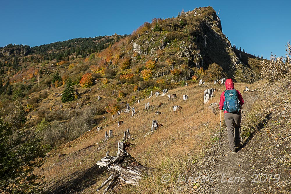
Although the skies were sunny and blue, chilly temps had us grabbing our jackets when we stepped out of Nick's truck. From the trailhead, an immediate steep climb up the Boundary Trail warmed us quickly. Colorful huckleberry bushes dressed in their finest autumn hues dotted adjacent hillsides, the predominant vegetation in the blast zone. Located directly north of Mt St Helens, when the volcano blew in 1980, this area took a direct hit. Barren slopes stretched far and wide, a sobering reminder of the eruption's tremendous force.
 |
| Brightly colored huckleberry bushes |
A two-mile climb brought us to Norway Pass and it's iconic views of Mt St Helens and Spirit Lake. The recently snow-dusted mountain and blue waters of Spirit Lake made great photo subjects for my camera. As many times as I've seen Spirit Lake, it always amazes me that there are still logs from the eruption floating in it's waters.
 |
| Mt Rainier view |
Past Norway Pass the Boundary Trail kept climbing, treating my friends and I to more spectacular views of Mt St Helens and Spirit Lake. Fall colors continued to impress, coloring the hillsides in red and yellow. Soon, we noticed Mt Rainier peeping over the northern horizon. At one point Nick spotted a herd of mountain goats in a valley far below the trail.
 |
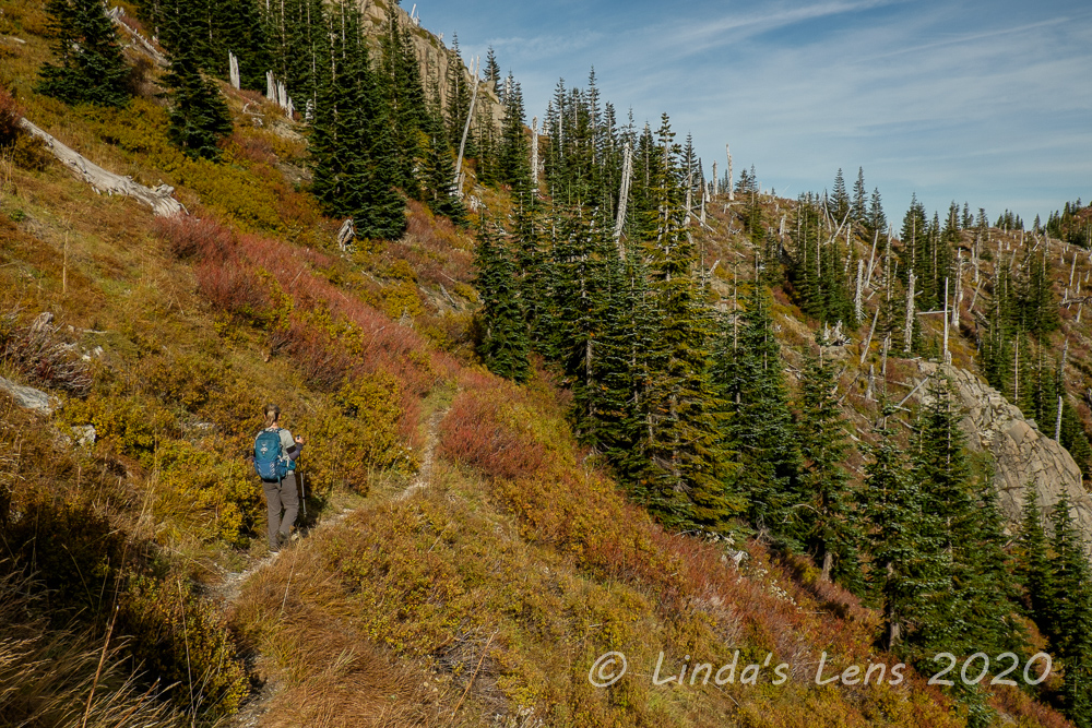
| We started to see snow on the trail |
A tiny pit of dread sat in my stomach as we got closer to the Whittier Ridge Trail. It didn't help that we ran into snow about a mile before the junction. Although Jenny assured me we'd turn around if the trail got too gnarly, I suspected my adventurous companion's definition of gnarly was different from mine.
 |
| Whittier Ridge trail junction |
Five miles from the trailhead we came upon the Whittier Ridge junction, marked with a simple wooden sign. Decision time - should we continue? Although the presence of snow made me pause, Jenny and Nick both wanted to try it. "We'll just go a little ways and check things out" Jenny promised.
 |
| Our lunch spot on the side of a cliff |
Leaving an open ridgetop, our trail dived into a forested, shady area where the snow had been slow to melt. Right away we encountered a snowpacked trail that was very slippery. Gingerly I inched my way across the icy tread. The trail narrowed and the downslope side began to get steeper, the ground below shrinking farther and farther away. And I was still on ice. About this time I was kicking myself for leaving my microspikes in Nick's truck (It didn't occur to me that we'd likely encounter snow and ice at higher elevations).
 |
| Fabulous scenery - treacherous trail |
Thankfully the trail finally wandered into an open area, where the snow had all melted. Now we were just traversing a narrow shelf on the side of a steep slope. Despite the precarious path, the views were amazing. Rocky, barren mountains stretched out in all directions. A tiny glacial lake sat nestled in a steep valley far below.
 |
| Where's the trail? |
By now it was way past noon, and my companions and I were getting hungry. Not finding a good place to stop for lunch, Jenny and Nick settled on a cliffside ledge. Although seating was a bit tricky, the views couldn't be beat! We looked down into a lovely blue lake rimmed by rocky walls. Mt Rainier anchored the skyline. We even saw a herd of elk down by the water (but too far away for photos).
 |
| More Rainier views |
As my friends and I were packing up lunch, two young men hiked by, traveling in the opposite direction. Inquiring about trail conditions, the men said the trail was tough but do-able. Resuming our trek, we ran into a solo woman hiker and she echoed the same opinion. The woman said she'd called the ranger district the day before and they'd warned her the trail was unsafe and recommended not hiking it. But she said it "wasn't that bad." (However, I noticed microspikes hanging on her backpack)
 |
| Photo op on top of the ridge |
Buoyed by our fellow hiker's advice, my companions and I soldiered on, following a faint bootpath across the face of another cliff. We passed the sides of three tall rock pillars, soaring high above our heads. Here the trail was again a narrow shelf, the ground falling steeply away on the downslope side. I kept my body as close to the vertical rock wall as possible, grabbing onto occasional handholds when things got a little scary.
 |
| Jenny trying to find the route |
Jenny, in the lead, came to another pillar, a tumbled mess of rocks, with no discernible trail. Which way to go? A few faint footprints in some mud between boulders were our only clue. Slowly, we wound around the side of this outcrop, only to encounter yet another one.
 |
| Picking our way across the ridgetop |
And then the trail dived into an area shaded by sparse trees and the rock wall itself. Un-melted snow covered the route, churned by hiker's footprints and frozen into a lumpy mess. Directly downhill was a steep, rocky slope. A slip would not be pretty. Not wanting to risk sliding, Jenny sat down and butt-scooted across this icy section. I followed suit, my heart pounding the entire time. But we both successfully traversed our first icy spot. Yes, our first - little did we know there was much more to come.
 |
| When I wasn't hanging on for dear life, I did enjoy the scenery |
About halfway across, our trail deadended on top of a cliff. The adjacent land dropped away steeply on three sides. Jenny and I began to freak out - which way did we go now? She asked Nick, patiently following behind, if he could scout ahead and find the route. Nick disappeared down one side of the dropoff. A few moments later we heard him call out "this way!" Jenny and I gingerly lowered ourselves down the rocky cliff, holding on for dear life. Oh, what did I get myself into? I had to calm myself by saying a few "Hail Marys" in my head.
 |
| Trying not to slip on the icy snow |
The "trail" (and by now I was using this term very loosely) continued to wind along the side of another cliff, requiring more scary scrambling. When would it end? Although I thought about retracing my steps back the way I came, I also realized it meant negotiating those terrifying dropoffs once again. Over halfway along Whittier Ridge now, we were past the point of no return. I had no choice but to carry on and hope for the best.
 |
| Oh good, we found the trail! |
Much of our time was spent trying to determine the correct route of the trail. Sometimes we followed footprints in snow or mud, other times it was a faint bootpath hewn into the rock. Then we came upon the word "trail" and an arrow stenciled on the side of a boulder. The first direction of any kind, this called for a photo op!
 |
| Nick leading the way |
The constant climbing up and down, using my hands for balance and stability, and occasionally crab-walking through icy parts started to wear on me. My legs began to tremble with exhaustion, my arms ached from grabbing rocky handholds. And yet the ridge stretched onward, with no trail junction in sight.
 |
| Tiny lake way, way below us |
When I wasn't concentrating on not falling, I did occasionally look up and admire the scenery. And I even took a few photos now and then. The surrounding landscapes were stunning. Ridges stretched in all directions. Tiny blue glacial lakes nestled in valleys far below. I even glimpsed Coldwater Lake and it's surrounding mountains spotted with orange hues of fall colors - a place I'd hiked just the week before.
 |
| Coldwater Lake and fall colors |
And then, just when I thought I couldn't take any more scrambling, the terrain widened out into a broad ridge. Now the walking was easy - we just followed the very apex. Instead of rocks, the path wandered through grass and dirt. According to my gps we'd covered nearly two miles. The junction with the Lakes Trail (and the end of this trail from hell) wasn't far now.
 |
| Can you spot my companions? |
One more downslope to cross - the path dived through another steep slope covered in snow (which required a bit more butt-scooting). But now, thanks to Whittier Ridge, I was an experienced crab-walker and got through this final slippery slope with no issues.
 |
| I was never so happy to see this junction! |
And - up ahead was the junction with the Lakes Trail! It was marked by a lone wooden post, as the signs had fallen onto the ground. I was never so happy to see a set of wooden signs. The Whittier Ridge scramble was finally done - thank goodness! Jenny, Nick and I agreed it had been a tough ramble - we couldn't believe the three hikers we'd spoke with had thought it "wasn't that bad."
 |
| Lovely fall color along the Lakes Trail |
But it was now 3:30 in the afternoon. It had taken us 2 1/2 hours to travel the 2-mile Whittier Ridge Trail. And we still had 7 miles yet to cover. Could we make it back to the trailhead before dark? After a very short snack break, my friends and I shouldered our packs and headed down the Lakes Trail.
 |
| The hiking was so much easier! |
After so much scrambling and route-finding it was a delight to follow a normal trail again. The Lakes trail meandered through a beautiful meadow full of colorful huckleberry bushes.
 |
| We survived the Whittier Trail! |
We even got a few more views of Mt Rainier!
 |
| Checking out Shovel Lake |
True to it's name, the Lakes Trail passed by several lovely water bodies. The first, Shovel Lake, was a deep blue-green color. We also passed by Panhandle and Obscurity Lakes. All three were popular backpacking destinations, with designated campsites requiring advance reservations. I eyed each lake and mentally made a note to try for a camping reservation next year.
 |
| Grizzly Lake |
Knowing we needed to beat sundown, my friends and I marched through the Lakes Trail, keeping breaks to a minimum. At one point, Jenny and Nick ran out of water and we stopped by a pretty creek so they could filter more. Then we began the steep climb out of the Lakes basin up to Bear Pass. Although I'd already hiked more than 10 miles, adrenaline kept my legs going as I powered up the switchbacks.
 |
| Sunset on Norway Pass |
Finally we topped out at Bear Pass. Although the views were spectacular, it was windy and cold. Jenny discovered she had phone service here, so we all took our phones off of airplane mode. I sent a quick text to my hubby that all was OK, and I was going to be very late. Then Jenny got a message that the alarm at her home had gone off. Worried, she called her alarm company, and spent the next several frantic minutes trying to determine what had happened. (Luckily she found out it was only her cat that had triggered the alarm)
 |
| Amazing light at sunset |
The setting sun flooded the landscape with amazing light. Colors glowed in pink and gold hues. I stopped so frequently to try and capture it all, I had to run down the trail to catch up with my friends. We arrived at Norway Pass just as the sun was sinking below the mountains.
 |
| Sky colors and Mt Adams |
What a great place to capture nightfall! It was the most amazing sunset I'd seen in a long time. Witnessing such a scene almost made the scary trek over Whittier Ridge worth it - well, almost.
 |
| Glowing sky over Mt St Helens |
But now we still had two miles to go, and it was nearly dark. Although I'd brought my headlamp, I was a little nervous about trying to find my way without daylight. Jenny and Nick, who had hiked at night many times, assured me that it would be a fun experience. And it was - although once the sun dropped temps got cold quickly. We hustled through the final two miles, ready to be done with what had already been a long, strenuous day.
 |
| Trying to beat the darkness |
Of course once we finally reached Nick's truck we still had a 3-hour trip to get home. Again, I was thankful for Nick's willingness to drive and kept him well supplied with snacks so he'd stay awake. We didn't reach Portland until 11 pm - and I finally hit my bed around midnight. What a day!
 |
| Day's final light |
The next day Jenny and I were in a meeting together at work. Of course we chatted about the previous day's adventure. Jenny joked that after that trail, I wouldn't ever want to hike with her and Nick again. But now with the Whittier Ridge trail experience behind us, we discussed if we'd ever want to hike it again. Yesterday, in the heat of the moment and scared out of our wits, we both had declared "never again!" But a day later, with bad memories already fading, Jenny said she might do it again. Now that I know what to expect, I might do it again too. But if there is a next time I'm starting earlier - and bringing my microspikes!
Either way, it was a true adventure. My toughest hike of the year, I logged a grand total of 15 miles and about 3500 feet of cumulative climbing. And earned bragging rights.
Oh you are brave to attempt these climbs Linda and I am delighted that you take some beautiful photographs along the way as there would be no other way of me seeing this fantastic scenery. Thanks for sharing.
ReplyDeleteHello, another WOW hike. The scenery is gorgeous, love the views of Mt Rainier and all the lakes. I can't believe you hiked 15 miles and went to work the next day. Beautiful photos. Enjoy your day, wishing you a great new week ahead.
ReplyDeleteSounds like a very intense experience...but those views! How neat that you have this beast of a hike under your belt!
ReplyDelete...Linda such beautiful sights, thanks for taking me along! My 'hike' today will be a walk on the beach.
ReplyDeletewhat a spectacular hike! Great ridge walks in this one. Stay way from the exposed snowy of icy trails. Just saying!
ReplyDeleteWow what an adventure! Your photos are wonderful!
ReplyDeleteLinda! Oh my gosh! I just yelled to Bob, "She's done it again!" These photos are some of your finest - that sunset was definitely spectacular! I've hiked/run in the mountains at night (I was a pacer for a friend in the Leadville 100 when I was about your age). I'll never forget that experience, and there wasn't even any ice on my part of the route! I think you should read Deep Survival by Larry Gonzales - I just finished it. You definitely kept your wits about you. (Thank goodness!) My adrenaline is high, and I'm just sitting at my kitchen counter...
ReplyDeleteWhat a spectacular hike! Incredible views! You can certainly handle adventures!
ReplyDeleteWhat an adventure you had, and the photos you managed to take are stunning. It must feel good to have this one under your belt!
ReplyDeleteWOW! What a hike indeed! That was like climbing one of Colorado's 14ers! The views of Mt St Helens and Mt Rainier in the distance are stunning and those blasted out trees makes one really realize the force of a volcano erupting. I was worried a few times for you reading this, as dusk here is dangerous as far as mountain lions on the prowl. I hope you carry bear spray
ReplyDeleteWow, I got scared just reading about it! That's funny about the cat though.
ReplyDeleteHmm, I'd have second thoughts on some places of that hike!
ReplyDeleteYou definitely earned maximum bagging rights. What a sensational, nerve wracking, awesome hike and finishing with such an amazing sunset over my favourite peak.
ReplyDeleteThis "trail" was laid out in the early 80's by St Helens Recreation Planner Francisco Valenzuela. He told the trail crew, "you will need more than a shovel to build this trail". At the end of August '21, after 35 years, he hiked the trail to continue the series of recovery photos he started making after the eruption. Francisco, "This trail is harder than some mountains I have climbed".
ReplyDelete