The year was 1995. I'd befriended a co-worker named Carol, an avid hiker. During the summer, Carol took me under her wing and introduced me to many of the popular trails in the Columbia River Gorge. She provided the spark that kindled within me, and grew into my current love of hiking. My obsession with self-propulsion to high places all began with Carol inviting me on a memorable climb that summer.
Size matters! Click on any image to enjoy a larger version.
 |
| Signing in at the Climber's register |
Carol's family purchased a permit to climb Mt. St. Helens, the northwest's most famous volcano. As everyone knows, MSH exploded spectacularly in May of 1980. For many years afterwards, the mountain was declared off-limits. But as things quieted down, the Forest Service slowly opened up areas surrounding the blast zone. By the summer of 1995, climbing to the summit was again allowed, but numbers were restricted to 100 people per day. To maintain the designated limit, visitors were required to obtain an advance permit, which allowed a party of up to twelve people.
 |
| The foresty portion of the trail |
So early one clear August morning, I joined Carol's family at the climber's bivouac, the official trailhead for the south climbing route up Monitor Ridge. Our party included Carol, her father, her two sisters, the youngest sister's boyfriend, and a friend of the other sister.
 |
| Huckleberry picking break |
We started out on a nice well-graded path through the forest. It was a pleasant first two miles, highlighted by a couple of huckleberry breaks from the bushes lining the trail. I began thinking this climb would be a piece of cake, but Carol's youngest sister warned me "take a good look at this trail, because on the way back it will seem never-ending."
 |
| Leaving the treeline |
We hit the treeline at the 4800 foot level. Beyond this elevation, climbing permits were required. As we ventured out of the forest into the barren, rocky wasteland, a final sign ominously reminded us of this fact. The climb would get tougher from here on out!
 |
| Clambering over large rocks |
Our trail disappeared, and we began navigating our way up the mountain following wooden posts stuck into rockpiles. The route steepened sharply, and we clambered along, scrambling over huge boulders, remnants of an old lava flow.
 |
| Follow the wooden posts |
At first, I found climbing the boulders to be great fun. But as we ascended and began to get fatigued, the novelty wore off. Would this rockpile ever end?
 |
| View to the summit ahead |
With no shade, the sun began to beat down upon us. But the clear, blue skies above made for some magnificent views, both of the forested valley below and the summit ahead.
 |
| Photo op at one of the monitors |
We came upon the first of two tripod-shaped monitors. These monitors consist of mirrors that reflect off of laser beams used to measure the mountain's swelling. These measurements aided scientists in the prediction of future eruptions. The monitors also made for a cool photo op.
 |
| The final trudge up an ash plain |
After climbing up yet another ridge of boulders, my party came upon the second monitor. Beyond this device, the boulder field thankfully ended. But it was replaced with something even tougher - a steep plain of fine-grained volcanic ash. Traveling through this ash was like walking in sand. Ascending the slope, it seemed I slid down two steps for every one I took up. Progress was painfully slow. I didn't think I'd ever make the summit.
 |
| Summit victory photo! (Mt.Adams in the background) |
I inched my way slowly up the crumbly ash slope. Step by step, the crater rim began to get closer. Finally, after what seemed an eternity, I pulled my weary body to the very top of the mountain. And, oh what glorious views awaited!
 |
| Views from the top - Spirit Lake and Mt. Rainier |
This was my reward - magnificent vistas in all directions. To the east you could see Mt. Adams. To the south, a hazy Mt. Hood beyond the forests and lakes. But the most amazing view of all was the view to the north, into the crater itself.
When MSH gave way, the eruption blew out the entire north side of the mountain. Standing up on the south rim, one could see crater walls on three sides, with a barren plain extending north. The steep crater walls were a multitude of grays and browns. The sparkling blue waters of Spirit Lake stretched beyond the rocky plain. And far in the distance, snow-capped Mt. Rainier poked above the horizon.
 |
| Lava dome inside the crater |
But the lava dome in the crater's center stole the show. It was an amazing mass of steaming brown lava. Kind of looked like a giant cowpie! The dome was supposedly still growing, albeit very, very slowly.
 |
| Resting up before tackling the trip down |
The steep climb up had been tough on Carol's middle sister and her friend, and they lagged behind the rest of us. So once on top, we had a snack, and laid down in the sun to wait for the last two members of our party to arrive.
 |
| Lots of people on the summit |
We were by no means alone on the summit! By mid-day, a large crowd of hikers had amassed along the crater rim. Everyone was either peering into the caldera, resting, taking photographs, or having lunch. It was an interesting group of happy hikers, all enjoying a wonderful sunny day atop the mountain.
 |
| Heading down |
Carol's sister and her friend finally joined us at the summit, 45 minutes after our arrival. We allowed them time to rest and refuel, but by then it was past mid-day, and we still had a mountain to descend. Time to pack up and bid this spectacular crater rim goodbye.
 |
| Sliding down the ash plain |
Although coming down was way easier than climbing up, the slippery, sandy slope was by no means a walk in the park. Being novice hikers, no one had gaiters, and the fine-grained ash poured into our boots as we slid down the mountain, necessitating many "dump out your boot" breaks.
 |
| Some people decided to glissade down a small snowfield |
There was a party of three men that had the right idea. They found one of the few remaining snowfields clinging to the side of MSH, and easily slid down the icy slope. That looked like a much better way to go - at least snow in your boots wasn't as irritating as gritty ash. (Disclaimer - I've since learned from my mountain climbing friends that you have to be very careful when glissading down an icy mountain slope. It's very easy to slide out of control, and you need to have an ice axe at the ready to control speed).
 |
| Water break |
The trip down the ash plain was the easy part of our descent. By the time we'd returned to the lava boulder field, my quads were beginning to feel shaky. But now we had to climb back down over all these huge rocks. Down climbing large boulders did not help in the least!
 |
| View from the monitor |
My legs began to protest. I inched ever so slowly down the lava field, making frequent stops to rest my weary quads. Carol's dad, younger sister, and her boyfriend, being much fitter than me, blazed along far ahead. But Carol, being the good friend she was, stuck with me and offered encouragement.
 |
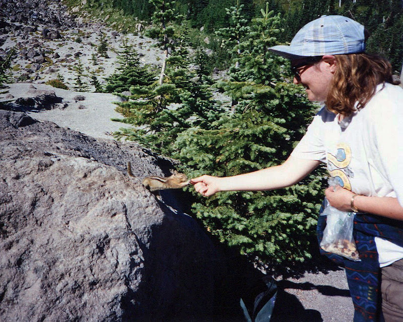
| Picking our way down the rocks |
After what seemed an eternity, we came upon the treeline, and the beginning of the forest trail. As Carol and I took a breather, a cute little chipmunk popped out from the bushes and leaped onto an adjacent rock. The little fella was obviously used to hikers, and began a routine of absolute cuteness, trying to persuade us to part with our trail mix. Yes, it worked. We were such suckers!
 |
| Begging chipmunk |
Then came the endless hike through the forest. And Carol's sister was so right! The trail seemed to go on and on. By then my body was totally thrashed, my legs aching, my feet blistered. I've never wanted to be done with a hike so badly. The parking lot was such a welcome sight!
Total stats for the day: 9.5 miles round-trip, a whopping 4500 feet elevation gain. (No wonder my legs were dead!)
 |
| The south side of MSH, our climbing route (in July 2009) |
That's my tale of my first, and only climb of Mt. St. Helens. While digging through my old photo albums, I found these images. I decided these would be great subjects to scan and use as a blog post. So all of these photographs (except for the last one) are from an old film SLR camera that I lugged all the way to the crater rim and back. Some of the prints look a little faded and the colors are funky, but the memories are as clear as ever.
MSH has always fascinated me. Every summer I do at least one hike around its base. This year, I think it's time to try for the summit again. Whether I ski up it (which is something I've always wanted to do) or wait until the summer months to hike it, summitting MSH is now firmly on my 2012 hiking wish list. Stay tuned for updated photos and story, coming to a blog near you!


No comments:
Post a Comment
Don't be shy! Please leave a comment.