Tuesday, April 17, 2012

A Bluebird Day

Last weekend, the weather guessers predicted clear skies and warm temps.  Can you say bluebird day?  Time to head for the mountain and partake in some spring skiing.


We found this little snowman on a terrain park feature

My friend Dean was game.  As per usual, our drive to Hood was fraught with rain and low clouds, causing us to doubt the weatherman.  But once we hit the east side of the mountain, it was all blue sky, all the time.


Dean models his new (very bright!) jacket

Dean employed his spring skiing strategy.  Start at the lowest runs, where the snow will be soft first.  When those slopes turn to mush, head for higher ground.  Keep following the slopes higher, with the goal to catch optimum snow conditions in each elevation zone.  We were going to hit the Stadium run first, but by the time we got to the top, Ski Patrol had already roped it off for races.  This forced us down through the terrain park instead.


Hmm.....Guess it's a snowWOMAN!

I usually avoid the terrain parks (too many snowboarders and young males jumping out everywhere).  But at that early hour, we had the place to ourselves.  The newly-groomed snow was like velvet!  We had such a great run, we came back and did it again. 

Dean spotted this little snowman sitting on top of a jump.  Upon closer inspection, it was realized we'd gotten its gender wrong. 


Dean doing the ski dance

We moved up to the runs off the Shooting Star lift.  And had some most excellent turns in the sun-softened snow.


A moon for Moon Bowl

Dean looked longingly into Heather Canyon.  Although the snow was pretty chewed up, things appeared to be skiable.  We decided to try Moon Bowl.  I told Dean it would be a great photo to get someone mooning the Moon Bowl sign.  But Dean wasn't game (can't imagine why!) so this was the closest to a moon I could get.


Dean on the top of Heather Canyon

Moon Bowl had the most wonderful snow!  And no one was skiing here.  Dean and I had such a great run, we  headed back up the lift and did it again.  By the second time around, the word was out, and this run we had plenty of company (we're such trendsetters!).


Looking up Heather Canyon towards Hood

Dean got himself a new jacket in a fluorescent yellow color.  Now he stands out like a sore thumb on the slopes.  Which is kind of nice - I'll never lose him again! (But I may need to wear my sunglasses skiing with him on these bluebird days!)


There goes Dean down Moon Bowl

After lunch, we headed up to the very top lift to check out the snow conditions.  We timed it pretty good, as the snow up here was the perfect carving softness. 


And....he's gone!

There's still so much snow up here that they actually dug a trench in one area under the lift to provide skiers enough clearance to get underneath.


Gray, dust-coated snowbanks line the parking lot

And the surplus of snow is very apparent in the main parking lot.  The entire area is ringed by a dirty wall of snow.  Yep - that large gray ridge you see in the above photo is all snow.  That's gonna hang around for awhile.


There's so much snow, they had to dig out the trail under this lift

By early afternoon, the snow at the bottom of the lift was starting to get sticky.  It was time to call it a day.  But we'd already gotten a full days worth of runs in (no lift lines!) so I was okay with quitting.  Besides, I had a half marathon race to run the next day and wanted to save a little energy for that. 

Yeah, you heard me right.  I was running a race the following day.  I know, not smart!  But I love skiing so much, I didn't want to give up a chance to ski on a perfect bluebird day.  I knew I'd probably pay for my decision, but reasoned that I wasn't running the race to win it (not by a long shot!). 

So......you're probably wondering - how did my race go?  Did I totally bonk?  Or did I have the run of my life with a huge PR?  Well, you'll have to stay tuned for my race report on the next blog post - and find out how I did!


Friday, April 13, 2012

I Heart Spring Skiing

Here in Portland, spring has arrived in a big way.  Flowers are emerging from the ground in colorful bursts, birds are singing, frogs croaking, trees exploding in blossoms everywhere.  Rain continues to fall (but it's much warmer).  And I'm still skiing.


Size matters!  Click on any photo to enjoy a larger version.

Yep, it's definitely spring in Portland

It's a weird feeling to be packing up to go skiing when the air outside is balmy.  To hear singing birds and see blooming trees as you're loading up the skis.  To be leaving your house in daylight.  To go from this colorful scene in my backyard......


Not spring

To this.  All white all the time.


I'm lovin' this endless winter

Despite the lure of warm weather at home, I love spring skiing.  The snow is plentiful, the crowds are nil, and the weather usually sunny.  No need to bundle up against blowing snow and cold.  And skiing snow that has been thawed by the sun is the best (after fresh powder of course!)


Looks more like January, doesn't it?

Katie (one of the tele-ladies) and I have spent the last two Fridays up on the mountain, enjoying some turns in the springlike conditions.


Mt. Jefferson is easy to spot

It's great to able to see the adjacent mountains and forests from high up on Mt Hood Meadows' slopes.


Katie and I enjoying the fabulous view

To see clearly the snow-capped top of Hood against a brilliant blue sky. 


Hooray for spring skiing!

And to make turns through buttery, sun-softened, corn snow.


No shortage of snow here

While other parts of the US have been suffering from low snow this year, the Cascades have enjoyed a banner spring.  This photo was taken last Friday.  Yes, there's still huge mounds of snow on the ground, and piled up around the lodge.  Meadows reported a 170-inch base that day.


Perfect turns on hero snow (Photo by Grant Myrdal)

I've had bad luck with my cameras.  The first Friday Katie and I skied, my little pocket camera broke.  The following Friday, I dug out my old back-up camera.  I managed to get off one shot before the battery died! 


Gettin' closer (Photo by Grant Myrdal)

So I had to rely on my buddy, photographer Grant for some photos from the day.  As you can see, he came through!


Catch me if you can!  (Photo by Grant Myrdal)

I love seeing photos of myself making tele-turns.  And I think I've improved over the season.  Just in time to fully reap the benefits of spring skiing.


Tuesday, April 10, 2012

Oneonta Trail

Portland finally got a break this weekend from the endless March rain (I was beginning to forget what sunshine looked like!)  My son Cody was home for Easter break, and we both decided to take advantage of the good weather with a hike in the Columbia River Gorge.


Size matters!  Click on any photo to enjoy a larger version.


Mandatory trail sign photo

I haven't been in the Gorge since my New Year's Day waterfall photo junket.  With all the recent rainfall, the sheer amount of water flowing into local streams meant the Gorge cascades would be spectacular.  A waterfall hike was in order!  And I knew just the trail - time to pay a visit to Oneonta Gorge.


Moss-covered rock wall lines the trail

There are many waterfall trails in the Columbia Gorge Scenic Area.  And they are all delightful.  But the Oneonta Trail gives the most bang for the buck.  In a mere two miles one can visit three (count 'em - three!) lovely falls.  Since Cody and I needed to be back in town by mid-afternoon, this short, view-packed hike fit the bill perfectly.


The trail squeezes between forest and a steep cliff

The trail begins at a large parking lot off the Old Columbia River Scenic Highway.  Right across the road is the very first waterfall - Horsetail Falls.  Most visitors only venture far enough to snap a couple photos of this tall, impressive cascade.  But if one treks past the trailhead, rewards are great indeed.


First glimpse of Ponytail Falls

Cody, Bear, and I switchbacked up the first ridge.  Typical of many Gorge trails, the first 0.2 of a mile was lined with several old mossy, stone walls.  Ferns draped over the wall's upper reaches.  Further up, we passed through a couple of rockslides and old gnarled trees, all covered in olive-green moss.  That's what nearly 8 inches of rain in a month will do.


Ponytail Falls and the trail behind

First on our tour - the lovely Ponytail Falls, only 0.4 mile from the trailhead.  This waterfall is especially cool as the trail routes behind the falls.  I'm told the lava flow that created this cascade's slot also buried a layer of soft soil.  The fall's constant flow over time has eroded this soil layer, creating a small cavern.  It's a very fun place to take young kids (even old kids too!)  Who doesn't get a kick out of walking through a cave that's BEHIND a waterfall?


Lovely Columbia River view

After a brief photo session at Ponytail Falls, it was time to move on.  The next highlight on the trail is a Gorge viewpoint jutting out over a cliff edge.  The vistas up and down the Columbia River are most excellent.  The clear sky meant one could see forever up and down the Gorge.  I caught glimpses of Beacon Rock and Hamilton Mountain to the east.


Close up of riverside pond


And from my perch, I really noticed the high river levels of the Columbia.  Water spilled over into the adjacent low-lying plains, flooding trees and creating small ponds.  One little pond had the most beautiful blue cast to its water.  I tried capturing the color with my camera, but the above photo doesn't do it justice.


First trillium of the year!

As we left the viewpoint to continue our trek, Cody spotted a small cluster of trilliums beside the trail.  Of course that was occasion for me to whip my camera back out!  (Which elicited a groan from Cody)  The sighting of these delicate, white flowers signals that spring is here to stay.


Mossy "weeping wall"

More interesting sights awaited.  Cody and I passed by a moss-covered rock wall that was dripping with narrow rivulets of water.  We paused and watched tiny streams cascade down the steep cliff face, forming small wet explosions as they hit clumps of moss.  It was mesmerizing.


The trail switchbacks down to Oneonta Gorge

Beyond the weeping wall, our trail switchbacked dramatically down to a footbridge crossing Oneonta Gorge, losing quite a bit of elevation in a very short distance.  It was an interesting viewpoint standing at the top of the ridge looking down over the sinuous path to the creek below.  Oneonta Gorge itself is another amazing sight.  It's a very narrow crack in the adjacent rock cliffs through which a creek flows.  I tried to capture a photo of this phenomenon, but due to lousy light, it wasn't worth sharing here.  There are waterfalls above and below the bridge, and I did capture a semi-decent pic of Oneonta Falls on my return trip (you'll see the photo later on in this post - I promise!)


Bear resting in the sunshine

After a trail junction, Cody and Bear (with me straggling along in the rear) climbed up to the next waterfall viewpoint.  This one was the best of all - Triple Falls.  One waterfall is great, but three for the price of one?  There was a huge group at the overlook as we walked by, so Cody and I elected to continue up the trail for a short distance, and chose a lunch spot by the roaring creek above Triple Falls.  It was a beautiful spot, complete with mossy boulders, small cascades, tall Doug Fir trees, and a nice sunny spot for Bear to relax (when he wasn't begging for a piece of my sandwich).


Triple Falls

We hit Triple Falls on our way back.  By this time, the large group had cleared out, but there was still another small party perched on the overlook.  No matter, the light wasn't great for photos, so I only made a couple image attempts before we packed up and moved on.   Triple Falls is really a neat waterfall and my intent was to produce a photo that did it true justice.  But alas, this sad image is the best that I could do (but aren't these falls cool?).


Oneonta Falls


Cody and I traveled back down to Oneonta Gorge.  This time the light was a little bit better, and I was able to get a semi-decent shot of Oneonta Falls.  By this time, it was early afternoon, and there was now a steady stream of people tromping down the switchbacks and across the bridge.  Sunny dry days bring hikers to the Gorge in droves!


My son and I

Cody's not fond of being in photos, especially when his mom is running the camera.  I tried to refrain from including him in my shots, but really wanted at least one image of my son and I to remember this great day.  Cody, being the good son that he is, decided to humor his mother.   Thanks to my tripod and timer, we posed on the Oneonta Gorge bridge and made this photo happen. 

After a busy winter of skiing, it was great to lace up my hiking boots again.  And there's nothing better than a waterfall hike in the Gorge on a sunny spring day (well.....except maybe a sunny powder day on the mountain).

(Oh - And I just realized I can't count.  There are actually FOUR waterfalls on this hike.  I forgot about Horsetail Falls at the parking lot).    :)


Wednesday, April 4, 2012

Climbing Mt. St. Helens - Photos From the Past

The year was 1995.  I'd befriended a co-worker named Carol, an avid hiker.  During the summer, Carol took me under her wing and introduced me to many of the popular trails in the Columbia River Gorge.  She provided the spark that kindled within me, and grew into my current love of hiking.  My obsession with self-propulsion to high places all began with Carol inviting me on a memorable climb that summer.


Size matters!  Click on any image to enjoy a larger version.


Signing in at the Climber's register

Carol's family purchased a permit to climb Mt. St. Helens, the northwest's most famous volcano.  As everyone knows, MSH exploded spectacularly in May of 1980.  For many years afterwards, the mountain was declared off-limits.  But as things quieted down, the Forest Service slowly opened up areas surrounding the blast zone.  By the summer of 1995, climbing to the summit was again allowed, but numbers were restricted to 100 people per day.  To maintain the designated limit, visitors were required to obtain an advance permit, which allowed a party of up to twelve people.


The foresty portion of the trail

So early one clear August morning, I joined Carol's family at the climber's bivouac, the official trailhead for the south climbing route up Monitor Ridge.  Our party included Carol, her father, her two sisters, the youngest sister's boyfriend, and a friend of the other sister. 


Huckleberry picking break

We started out on a nice well-graded path through the forest.  It was a pleasant first two miles, highlighted by a couple of huckleberry breaks from the bushes lining the trail.  I began thinking this climb would be a piece of cake, but Carol's youngest sister warned me "take a good look at this trail, because on the way back it will seem never-ending."


Leaving the treeline

We hit the treeline at the 4800 foot level.  Beyond this elevation, climbing permits were required.  As we ventured out of the forest into the barren, rocky wasteland, a final sign ominously reminded us of this fact.  The climb would get tougher from here on out!


Clambering over large rocks

Our trail disappeared, and we began navigating our way up the mountain following wooden posts stuck into rockpiles.  The route steepened sharply, and we clambered along, scrambling over huge boulders, remnants of an old lava flow.


Follow the wooden posts

At first, I found climbing the boulders to be great fun.  But as we ascended and began to get fatigued, the novelty wore off.  Would this rockpile ever end?


View to the summit ahead

With no shade, the sun began to beat down upon us.  But the clear, blue skies above made for some magnificent views, both of the forested valley below and the summit ahead.


Photo op at one of the monitors

We came upon the first of two tripod-shaped monitors.  These monitors consist of mirrors that reflect off of laser beams used to measure the mountain's swelling.  These measurements aided scientists in the prediction of future eruptions.  The monitors also made for a cool photo op. 


The final trudge up an ash plain

After climbing up yet another ridge of boulders, my party came upon the second monitor.  Beyond this device, the boulder field thankfully ended.  But it was replaced with something even tougher - a steep plain of fine-grained volcanic ash.  Traveling through this ash was like walking in sand.  Ascending the slope, it seemed I slid down two steps for every one I took up.  Progress was painfully slow.  I didn't think I'd ever make the summit.


Summit victory photo! (Mt.Adams in the background)

I inched my way slowly up the crumbly ash slope.  Step by step, the crater rim began to get closer.  Finally, after what seemed an eternity, I pulled my weary body to the very top of the mountain.  And, oh what glorious views awaited! 


Views from the top - Spirit Lake and Mt. Rainier

This was my reward - magnificent vistas in all directions.  To the east you could see Mt. Adams.  To the south, a hazy Mt. Hood beyond the forests and lakes.  But the most amazing view of all was the view to the north, into the crater itself. 

When MSH gave way, the eruption blew out the entire north side of the mountain.  Standing up on the south rim, one could see crater walls on three sides, with a barren plain extending north.  The steep crater walls were a multitude of grays and browns.  The sparkling blue waters of Spirit Lake stretched beyond the rocky plain.  And far in the distance, snow-capped Mt. Rainier poked above the horizon.


Lava dome inside the crater

But the lava dome in the crater's center stole the show.  It was an amazing mass of steaming brown lava.  Kind of looked like a giant cowpie!  The dome was supposedly still growing, albeit very, very slowly.


Resting up before tackling the trip down

The steep climb up had been tough on Carol's middle sister and her friend, and they lagged behind the rest of us.  So once on top, we had a snack, and laid down in the sun to wait for the last two members of our party to arrive.


Lots of people on the summit

We were by no means alone on the summit!  By mid-day, a large crowd of hikers had amassed along the crater rim.  Everyone was either peering into the caldera, resting, taking photographs, or having lunch.  It was an interesting group of happy hikers, all enjoying a wonderful sunny day atop the mountain.


Heading down


Carol's sister and her friend finally joined us at the summit, 45 minutes after our arrival.  We allowed them time to rest and refuel, but by then it was past mid-day, and we still had a mountain to descend.  Time to pack up and bid this spectacular crater rim goodbye.


Sliding down the ash plain

Although coming down was way easier than climbing up, the slippery, sandy slope was by no means a walk in the park.  Being novice hikers, no one had gaiters, and the fine-grained ash poured into our boots as we slid down the mountain, necessitating many "dump out your boot" breaks.


Some people decided to glissade down a small snowfield

There was a party of three men that had the right idea.  They found one of the few remaining snowfields clinging to the side of MSH, and easily slid down the icy slope.  That looked like a much better way to go - at least snow in your boots wasn't as irritating as gritty ash.  (Disclaimer - I've since learned from my mountain climbing friends that you have to be very careful when glissading down an icy mountain slope.  It's very easy to slide out of control, and you need to have an ice axe at the ready to control speed).


Water break

The trip down the ash plain was the easy part of our descent.  By the time we'd returned to the lava boulder field, my quads were beginning to feel shaky.  But now we had to climb back down over all these huge rocks.  Down climbing large boulders did not help in the least!


View from the monitor

My legs began to protest.  I inched ever so slowly down the lava field, making frequent stops to rest my weary quads.  Carol's dad, younger sister, and her boyfriend, being much fitter than me, blazed along far ahead.  But Carol, being the good friend she was, stuck with me and offered encouragement. 


Picking our way down the rocks

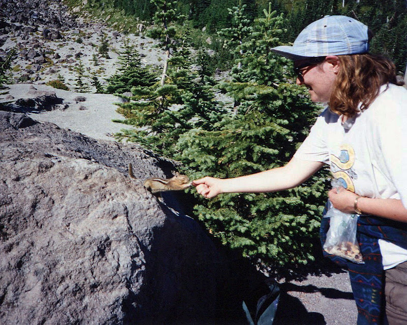
After what seemed an eternity, we came upon the treeline, and the beginning of the forest trail.  As Carol and I took a breather, a cute little chipmunk popped out from the bushes and leaped onto an adjacent rock.  The little fella was obviously used to hikers, and began a routine of absolute cuteness, trying to persuade us to part with our trail mix.  Yes, it worked.  We were such suckers!


Begging chipmunk

Then came the endless hike through the forest.  And Carol's sister was so right!  The trail seemed to go on and on.  By then my body was totally thrashed, my legs aching, my feet blistered.  I've never wanted to be done with a hike so badly.  The parking lot was such a welcome sight!

Total stats for the day: 9.5 miles round-trip, a whopping 4500 feet elevation gain. (No wonder my legs were dead!)


The south side of MSH, our climbing route (in July 2009)

That's my tale of my first, and only climb of Mt. St. Helens.  While digging through my old photo albums, I found these images.  I decided these would be great subjects to scan and use as a blog post.  So all of these photographs (except for the last one) are from an old film SLR camera that I lugged all the way to the crater rim and back.  Some of the prints look a little faded and the colors are funky, but the memories are as clear as ever. 

MSH has always fascinated me.  Every summer I do at least one hike around its base.  This year, I think it's time to try for the summit again.  Whether I ski up it (which is something I've always wanted to do) or wait until the summer months to hike it, summitting MSH is now firmly on my 2012 hiking wish list.  Stay tuned for updated photos and story, coming to a blog near you!