Saturday, August 31, 2013

Whetstone Mountain

Half the adventure was just getting to the trailhead....


Fireweed along the road

I had a Friday off and yearned to hike one of Sullivan's 100 trails on my ever-shrinking list.  The climb to Whetstone Mountain was today's winner.  Although the hike itself is not difficult (a mere 4.8 mile trek with 1100 feet of elevation gain), getting to the trailhead was.  The remoteness of the area was the main reason I'd waited so long to check it off my list.


This trailhead sign has seen better days

The drive itself took nearly three hours.  Not totally because of distance - accessing this trail required lots of bumping around on narrow, winding, gravel Forest Service roads.  Not conducive to fast travel.  The trailhead was in the middle of absolute nowhere - even farther than the Bagby Hot Springs parking area (I know because I drove right past it). 


Bear is ready to go!

After passing Bagby, pavement quickly turned to gravel.  Watching my odometer, I came upon an unmarked road at the correct mileage.  Was this the way?

Taking a leap of faith, I turned down this narrow dirt track.  It didn't take long to realize the road had not seen any maintenance for quite some time.  Trees and brush became denser, and grew closer and closer to the gravel edge.  I came to areas where there was barely room for my car to squeeze through their branches.  It was a true tunnel of vegetation.  Hmmmm........ more than once I hoped I wasn't lost!


Huge old growth trees

I hit a couple areas where water had completely washed out the roadbed, creating huge potholes.  Gingerly, I steered my car through these bumps, praying it wouldn't bottom out.  I came upon one intersection that I thought was my turnoff, only to travel a short distance into a dead end.  No, it wasn't fun nor easy to turn my car around on that rocky, narrow "road" that dropped off on one side.


And huckleberries!

But things redeemed themselves in another mile when I came into a clearing chock-full of blooming fireweed.  Needing a break to read my map and go potty, photographing their bright petals made a good excuse to stop.  Then it was back on the road, resuming my hunt.  Not far from the wonderful fireweed meadow, I finally found the last intersection, with - yahoo - a sign to the trailhead.  Relief!  A short distance, and more bouncing over potholes later, Bear and I arrived at our destination.


Beautiful forest

Being it was such a production to reach this far-flung place, I was surprised to see three other cars in the parking area.  A lone man was loading his backpack, preparing to hit the trail.  We exchanged hellos and compared notes on our eventful drives in.  Then the guy took off, leaving me to get ready.


Large fungi

It was past 11 o'clock when my dog and I finally hit the trail.  Since the Whetstone Mountain Trail is not very well-known, my expectations were low.  But after a short downhill ramble, I came upon an incredibly beautiful old growth forest.


Wilderness area sign


The woods were full of amazingly large Douglas Firs.  Big patches of huckleberry bushes covered the forest floor.  Ferns, big and small grew prolifically.  And I discovered a bunch of cool giant fungi stuck on the side of some trees.


Bear quenches his thirst from a small pond

The huckleberries appeared to be ripe, so I sampled as I went.  Most of the berries were not quite ready and tasted sour.  But once and awhile I'd get a sweet one, and that kept me picking and eating.


Salmonberry bush

Huckleberries won't the only things ripening.  Continuing my trek, I began to see bright orange and red salmonberries lining the trail.  Although I think they're edible, having never tried them, I didn't want to take a chance.  So instead of being eaten, these beautiful berries got a photo session.


Colorful salmonberries

The trail kept climbing, sometimes rather steeply.  The day was becoming hot and humid, and I slogged along, hoping for the summit.  (Shouldn't it be right around the bend?)  On one of the switchbacks, I passed the man I'd seen earlier in the parking lot.  He too commented that the climb seemed to be taking forever.


Great vistas from Whetstone Mountain

But a final switchback led me to Whetstone Mountain's bald, rocky summit.  And, boy oh boy, what amazing views!  The rumpled green hillsides of the surrounding Bull of the Woods Wilderness spread out before me.  And a panorama of peaks lined the horizon in all directions.  To the south, Mt. Jefferson and Olallie Butte, to the west, the hills of the Opal Creek basin, and to the east, a distant Mt. Hood.  These wonderful vistas were totally unexpected from such a remote, unknown peak.


Looking towards Mt. Hood

Once a lookout tower location, all that remained were a couple of concrete foundation piers, with rusty bolts and nails sticking out.  If nothing else, good photo subjects.


Old lookout tower footing

I eagerly unpacked my lunch.  This would be a great spot to sit and enjoy my sandwich.  But no sooner had we arrived when a cloud of large, biting flies descended upon my dog and I.  Although they generally left me alone, those flies had it in for poor Bear.  They swarmed his body, landing in a cloud on his back.  Agitated, Bear kept shaking, moving around, and snapping his jaws at those pesky intruders.


Mt. Hood is barely visible through the haze

After five minutes, I realized we needed to leave.  My poor dog was being eaten alive by flies.  They were bothering him so much, Bear wasn't able to eat or drink.  Reluctantly, I packed up my food, and led Bear off the summit.


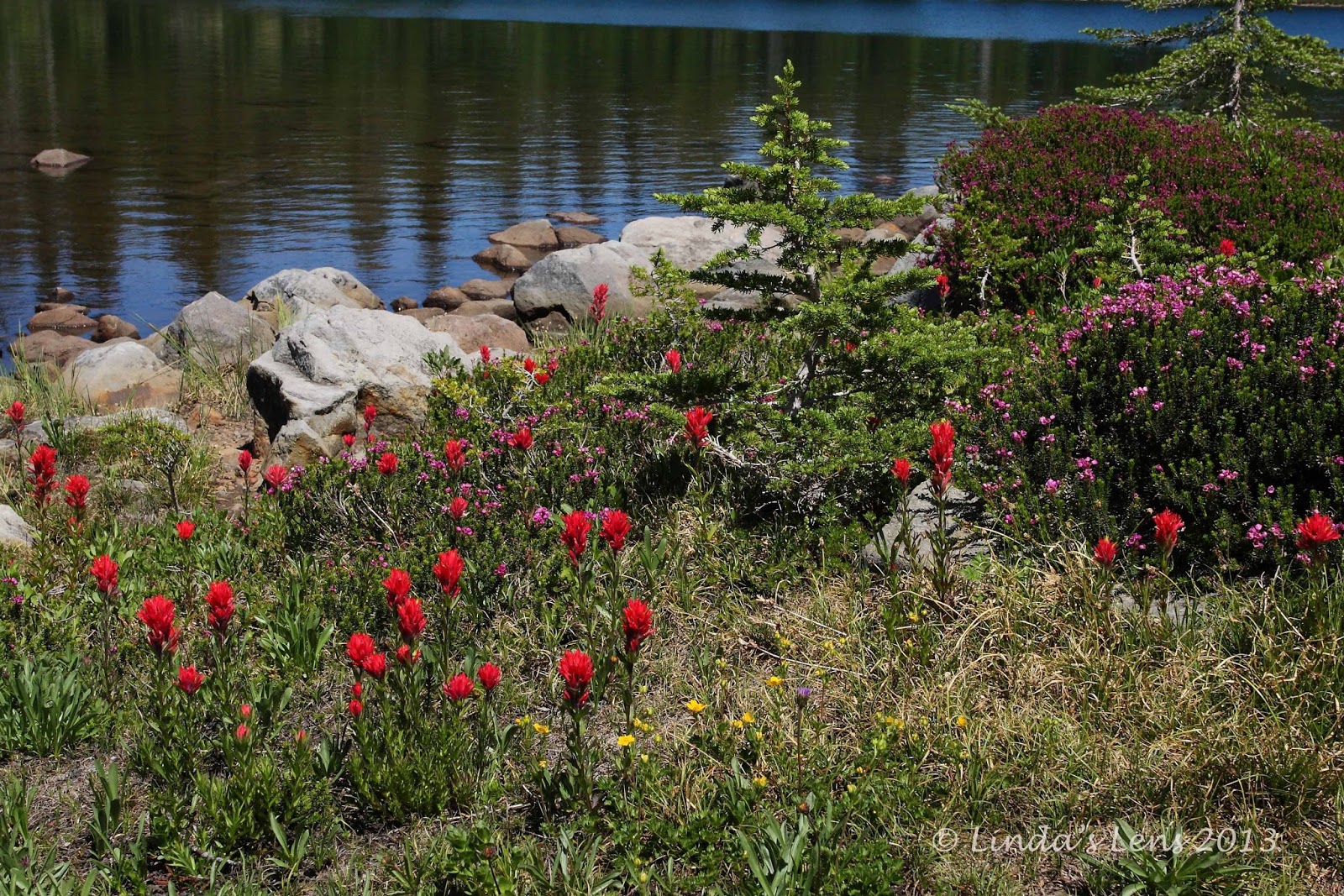
A few wildflowers still around

Although the trip to the top of Whetstone Mountain was a long, uphill slog, my return was fast and easy.  I zipped down the summit trail, past the salmonberries, until I found myself back at a little pond.  Bear happily guzzled the pond water, while I busied myself taking photos of some gorgeous vine maple leaves, just beginning to change color.


Fall colors are coming fast

The rest of the return trip was uneventful.  As I was nearing the parking area, I noticed clouds building through a forest clearing.  Today's forecast of thunderstorms appeared to be right on.  Guess it was a good thing Bear and I didn't dawdle on the summit.


Thunderhead building over the road

Of course, the only bad thing about driving a long distance on a bad road to reach your trail, is you must return the same way.  So once again, I carefully wound my car through the brushy path, over the potholes, until finally reaching civilization in the form of pavement.

Another hike checked off in my book!  This one, although short in distance, was a doozy to reach.  And my poor car took a beating - once I got home, I noticed lots of paint scratches along the entire length of the body.  Sigh - I apparently didn't avoid all the branches.  Good thing my car is getting old, I guess. 

But it was a fun adventure and, as always, great to be outside on a beautiful summer day.


Sharing with:  Weekly Top Shot.

Tuesday, August 27, 2013

Mountain Happiness

All week long, stuck at work, I dream of hiking.  I fantasize about the trails I'm going to explore, the vistas to see, the wonderful flowers that carpet the high country. 

When the weekend comes, I gleefully head to the woods.  Time to get my dose of mountain happiness!


Lovely Mt. Hood!

In early August, I had a yen to explore the east side of Mt. Hood.  The Elk Meadows Trail with a side trip to Gnarl Ridge makes an excellent summer hike.  I was delighted when my good friends John and Young agreed to join me.


Follow the trail

This trail starts near Mt. Hood Meadows Ski Area and meanders through a lovely fir forest thick with huckleberry bushes.  After crossing Clark Creek on a sturdy log footbridge, the path directs hikers to a roaring Newton Creek.  No nice bridge here, one must either wade, or balance on one of the precariously placed logs.


Crossing Newton Creek in the am

River crossings are always scarier than they look, and my party made it across Newton Creek no problem.  Then a steep, switchback-y trail took us up the opposite bank.


Mt. Hood view at Newton Creek

The forest here was interesting.  It was a mix of Douglas firs and tons of old, barkless trees that appeared to have died or were in the process of dying.  Some of these trees sported huge round burls in their trunks.  One of the burls looked exactly like someone's rear end.  We all had a good laugh about the "butt tree" and funny John posed for the shot below.


That tree burl looks like a .......!

A mile and a half of steady climbing brought us to Elk Meadows.  In early August, this beautiful alpine area usually boasts a huge display of wildflowers.  When my friends and I arrived, we were disappointed to discover the bloom was nearly over.  All that remained were a few scraggly stalks of lupine.  Usually this meadow is purple with the stuff.


Flower photo session

Hoping to find some flowers at higher elevations, my hiking buddies and I continued up the path until it intersected with the Timberline Trail.  Following the Timberline Trail from here, it was a steep mile and a half trudge to Gnarl Ridge.


Unknown purple flower

Although climbing in the midday heat wasn't a lot of fun, our efforts were rewarded with a few flower-spangled meadows.  The higher we climbed, the more the forest opened up, and the better the views became.


Almost above treeline

Finally, the forest gave way to small, scraggly whitebark pines, their trunks bent by fierce winds and bleached white by the sun.  Above the trees, Mt. Hood was now visible, her glaciers gleaming.


Looking down on Newton Creek from Gnarl Ridge

A rocky trail led us to the wonderful cliff-edge views of Gnarl Ridge.  Far down below, I glimpsed Newton Creek, it's snowmelt-fed waters roaring down the mountainside.  Having crossed this creek only a couple hours ago, it was amazing to see how high we'd climbed.  Across the canyon, I spotted the ski lifts of Mt. Hood Meadows.


Young takes in the views

But at Newton Canyon's highest point, Mt. Hood dominated the sky.  She sat tall, majestic and beautiful at the very top.  The mountain was so close I felt as if I could reach out and touch it.


A rock for three

Out in the open, brisk winds forced John, Young and I to don our jackets.  Then we perched on a large rock and dug into some lunch. 


Mt. Hood rises above the ridge

My friends and I spent at least an hour lounging on top of Gnarl Ridge, taking in the scenery, and snapping tons of photos.  The wind died down and temps became pleasant enough to bask in the sunshine.  Although a few hikers came by, they didn't stop, and we had the place to ourselves.


Scrubby, gnarled whitebark pines

After an idyllic break, it was time to pick up our packs and head back down.  John joked that the local brewpub was calling.  Young and I agreed this was good incentive for a quick return.


Heading back down

But.....with views like these, my camera and I were easily distracted.  Luckily I wasn't the only one.  Young and I are kindred spirits when it comes to capturing lovely scenes with our cameras.  Poor John!  He joked that we were secret sisters, separated at birth.


Lotsa lupine!

Young sprained her ankle earlier in the summer, and today's hike was only the second one she'd done since the injury.  All the way up to Gnarl Ridge she did fantastic.  But halfway down, things began to throb, and Young finally conceded to a rest break.


A cairn marks the Newton Creek crossing

Approaching Newton Creek for our second crossing, I noticed the morning's clear rushing stream had changed dramatically.  Afternoon snowmelt had transformed it into a wide, churning mass of brown silt.  The water level rose so much that it barely fit under the logs hikers were using to cross.


Afternoon crossing of a roaring Newton Creek

Shakily, I approached the slippery logs, and slowly inched across.  Roaring water directly below the logs was unnerving.  Creek crossings always scare me a little, and I was relieved when my feet finally touched the opposite shore's rocky bank.


Huckleberry break

Creek crossing now out of the way, I followed my friends through the brushy forest.  Young became distracted by some ripe huckleberries, and before I knew it, both she and John were stopped by the side of the trail, grabbing handfuls.  Hey guys - did you forget about the beer?


Busy bee

But this gave me an opportunity to photograph some frilly white flowers.  A busy bumblebee, intent on his pollen-gathering, struck a few poses for my lens.


Hello from the bridge!

Back across the Clark Fork footbridge, before I knew it we'd arrived at the parking lot.  Time to hit the pub!  Although hot, sweaty and thirsty, my mind and body were invigorated.  There's nothing like a trek through some high alpine country to reset my attitude.  I'd filled my tank with some mountain happiness.  It would get me through another week.

Back to work tomorrow - time to dream and plan for next weekend's hike.  And more mountain happiness.


Sharing with:  Tuesday Muse and Share Your Cup Thursday

Tuesday, August 20, 2013

Jefferson Park

After a great hike to Marion Lake with my hubby, I was hoping for a repeat the following day.  But poor Roger woke up the next morning with a sore shoulder.  No hiking for him!  Time to change plans.


Mt. Jefferson rises above the meadow

Now unable to join me, Roger decided he'd go fishing at Detroit Lake.  But he was willing to drop me off at a nearby trailhead.


My path to paradise

I was planning a hike close to Three Fingered Jack.  But that trailhead was a long drive from our campsite.  I perused my Sullivan book, searching for a closer trail.  The Whitewater Trail to Jefferson Park caught my eye.


The last of the Cascade Lilies

Although never having visited Jefferson Park, I'd heard lots about it.  This lake-dotted high meadow is extremely popular with hikers and backpackers.  Wildflowers bloom in abundance, and the view of Mt. Jefferson is second to none.  This place had long been on my "hiking bucket list."  Now was my chance to check it out.


The wonderful meadow

So Roger drove me down a long, dusty gravel road and left Bear and I at the Whitewater trailhead.  We both agreed to return by 4:30.  I had a little over seven hours to travel the 10 miles to Jefferson Park and back.


More lovely magenta paintbrush


The first mile and a half, the trail climbed steadily through a wonderful forest of huge Douglas Fir trees.  I appreciated their cool shade.  Though only mid-morning, temps were already heating up.


Bear resting in the flower field

After a long, sweaty climb, I reached a trail junction.  My path leveled out, and began to follow a ridge.  The forest gradually transitioned to a less dense mix of smaller firs, and soon I began to see remnants of flowers past their bloom.  I met a Boy Scout troop heading back to the parking area.  One of their leaders told me the group had just finished a four-day camping trip in Jefferson Park.  The boys still looked happy, but one of the adults admitted he was ready for a burger and a shower.


There was also some orange paintbrush

After another mile and a half, the forest really opened up.  And I got my first breathtaking view of Mt. Jefferson.  It rose like a wall and filled the horizon.  Although I tried to capture it with my camera, the sun was in a bad place, shining directly behind the peak.  Photos would have to wait for my return trip.


Amazing Mt. Jefferson view from Scout Lake

Although the sun wasn't cooperating, I trekked along, enjoying the magnificent scenery.  Not only the mountain, but the views down to the valleys far below were wonderful.  I spotted a teal-blue glacial lake in the midst of a dense green forest.


Bear cools his paws

Then the trail wound down to a crossing of Whitewater Creek.  A short distance further brought another trail junction with the Pacific Crest Trail (PCT).  Bear and I turned onto the PCT for our final mile to the first lake.


Mt. Jefferson extreme close-up

But before we reached the lake, I came upon the most beautiful meadow.  It was chock-full of wildflowers.  As you can imagine, my camera came out, and I spent the next half hour roaming the area capturing all the beauty my memory card would hold.  Purple lupine and paintbrush of both colors (orange and magenta) dominated the area, with some small yellow flowers thrown in.  The field was full of bees, flying from one blossom to the next.  The cumulative sound of all those bees buzzing was so loud, I don't think I've ever heard such a noise.


Still some beargrass blooming on the lake shore

But with a time limit on my hike, I finally tore myself away, and resumed forward motion.  Another half mile, the terrain leveled out, and the trees gave way to a large alpine meadow.  Following a well-rutted trail, I came upon Scout Lake, the first of many tiny lakes in Jefferson Park.


Magenta paintbrush was everywhere!

Hovering above Scout Lake, like a massive monolith, was none other than Mt. Jefferson.  Oh, what a sight!  I walked along the brushy shoreline until I came to a place that boasted a dead-on view of the mountain.  Perfect spot for lunch!


Scout Lake with Park Butte in the distance

I sat and ate my lunch, while Bear cooled his paws in the lake's crystal clear waters.  The shore was lined with campsites, most already taken by backpacking parties.  Several people were swimming, and many more sat on shore, dangling their feet in the lake.


More pretty lakeside flowers

Although the light still wasn't great for photos, I took tons of the lake and mountain anyway.  It was such great scenery, I had to try.  I could see why this area was so popular - it was amazingly beautiful.  I told myself I should've brought a tent and camping gear.  Jefferson Park was so wonderful, I didn't want to leave.


Scout Lake shoreline

Finally, I packed up and continued following Scout Lake's shoreline.  Flowers bloomed in some areas, mostly magenta paintbrush and pink heather.  Sunlight reflected on the lake's surface, making the water incredibly blue.  I passed some of the sweetest campsites, with killer mountain views.  More than a little jealous, I again wished I could stay the night.


Beautiful blue waters


Completing my circuit of Scout Lake, Bear and I returned to the main trail.  I really wanted to do some more exploring.  Russell Lake was another 0.7 mile further down the PCT, and there were three other small lakes in the immediate area.  But a check on my watch revealed if I wanted to be back by 4:30, I needed to turn around soon.  These lakes would have to wait for another day.  So, reluctantly, I began to retrace my steps back to the trailhead.


PCT through Jefferson Park

I did make time for another quick photo session at the flowerful meadow.  In the short time I spent there, at least a dozen people walked through, all heading for the lakes.  It was a Saturday, the flowers were in bloom, and the weather was good.  Prime time for the masses to visit.


PCT trail sign

Then, in order to get back in time, I had to put the pedal to the metal.  I marched steadily through the dusty trail in the afternoon's heat.  Poor Bear was tiring by now, and the hot weather didn't help.  I offered him water several times, but he hardly drank a drop.  I began to realize that maybe 10 miles was now too much for my old dog.


Another romp through the flowery meadow

As I traversed the ridge, I made sure to look behind and admire the picture-postcard views of Mt. Jefferson.  Afternoon light was now illuminating the mountain perfectly.  Much better for photography than the morning, I made sure to capture plenty of images.


Magnificent Jefferson views from the trail

Other than that, the trip back was uneventful.  I ran into several parties of backpackers, all heading for Jefferson Park.  Yes, this truly was a popular place.  But after today's visit, I understood why.

Bear and I emerged from the dusty forest at exactly 4:35.  Roger, waiting at the trailhead sign, was impressed by my punctuality.  Poor Bear made it all the way to the shade of Roger's truck before collapsing in the dirt.  My doggy was so tired, he couldn't even muster the strength to jump into the truck, and Roger had to lift him.


One final glimpse of this grand mountain

An interesting side note, the following week I received my September issue of Backpacker magazine.  One of the feature articles listed a hike with the best view for each state.  Guess which one was chosen for Oregon?  Yep - Jefferson Park!  Not only that, on the list of top 10 best views, Oregon's Jefferson Park came in at number 3 (it even beat out Colorado).  And I was just there!

A change in plans turned out to be a good thing.  I finally got to visit Jefferson Park - a delightful alpine paradise that I'd heard so much about.  It totally lived up to the hype!  Next time, I'm bringing my tent and staying awhile.


Linking with:  Tuesday Muse and Weekly Top Shot.