My final ski trip for the season was at a familiar place - Mt. Bachelor, up the road in Central Oregon. The largest ski area in the state, I'd swooshed down its slopes many times over the span of 30 years. As a matter of fact, Mt. Bachelor is my favorite place to ski in Oregon - and also is in the running for my favorite resort anywhere.
 |
| Beautiful view of Tumalo Mtn. |
The multi-resort IKON passes my friend Kim and I purchased this season allowed for 5 days here. We'd used one of the five in early January trying to ski on a miserable, rainy day. After that experience, we decided to save our remaining days for March, when the snow, and the weather were more reliable. (The Cascade Mountains usually get their highest amount of snowfall during the month of March.)
 |
| "The Cone" with all it's squiggly ski tracks |
After skiing other resorts (and our home hill, Mt. Hood) in January and February, the chosen month for our Mt. Bachelor trip finally arrived. The second Tuesday of March had Kim and I turning into its parking lot, eyeing the snowy, foggy conditions. Snow was falling heavily, which was good. However the swirling snow, combined with fog, made seeing where you were going mighty challenging. (We skiers refer to this reduced visibility as "skiing by Braille.")
 |
| Gotta do a ski selfie! |
No matter, we'd come to ski and ski we would! So Kim and I rode up the lift and carefully picked our way downhill. The newly-fallen snow was wonderful to swish through, and nearly made up for the lack of visibility. We had a great morning, and after a coffee and granola bar break for lunch, went out for more.
 |
| Super-long line to Summit Lift |
Although the second day began with more of the same weather as the first, it didn't take long for the snow to stop falling and skies to clear. Hooray! Sunshine and powder - my favorite! And temperatures remained cold, which helped the snow stay soft and fluffy.
 |
| Lots of sunshine! |
Conditions were good enough that Mt. Bachelor staff decided to run the Summit lift that afternoon. The highest chairlift at the resort, it takes skiers to the very top of 9,068-foot Mt. Bachelor. Due to its exposed location, the resort only opens it when there's low wind and high visibility. Kim and I happened to go by the bottom of Summit right as it opened. We considered taking a run from the top, but the humungous lift line changed our minds. It snaked all the way up the adjacent slope! There was plenty of other places to ski that weren't crowded, especially now that half of the people were in line for the summit.
 |
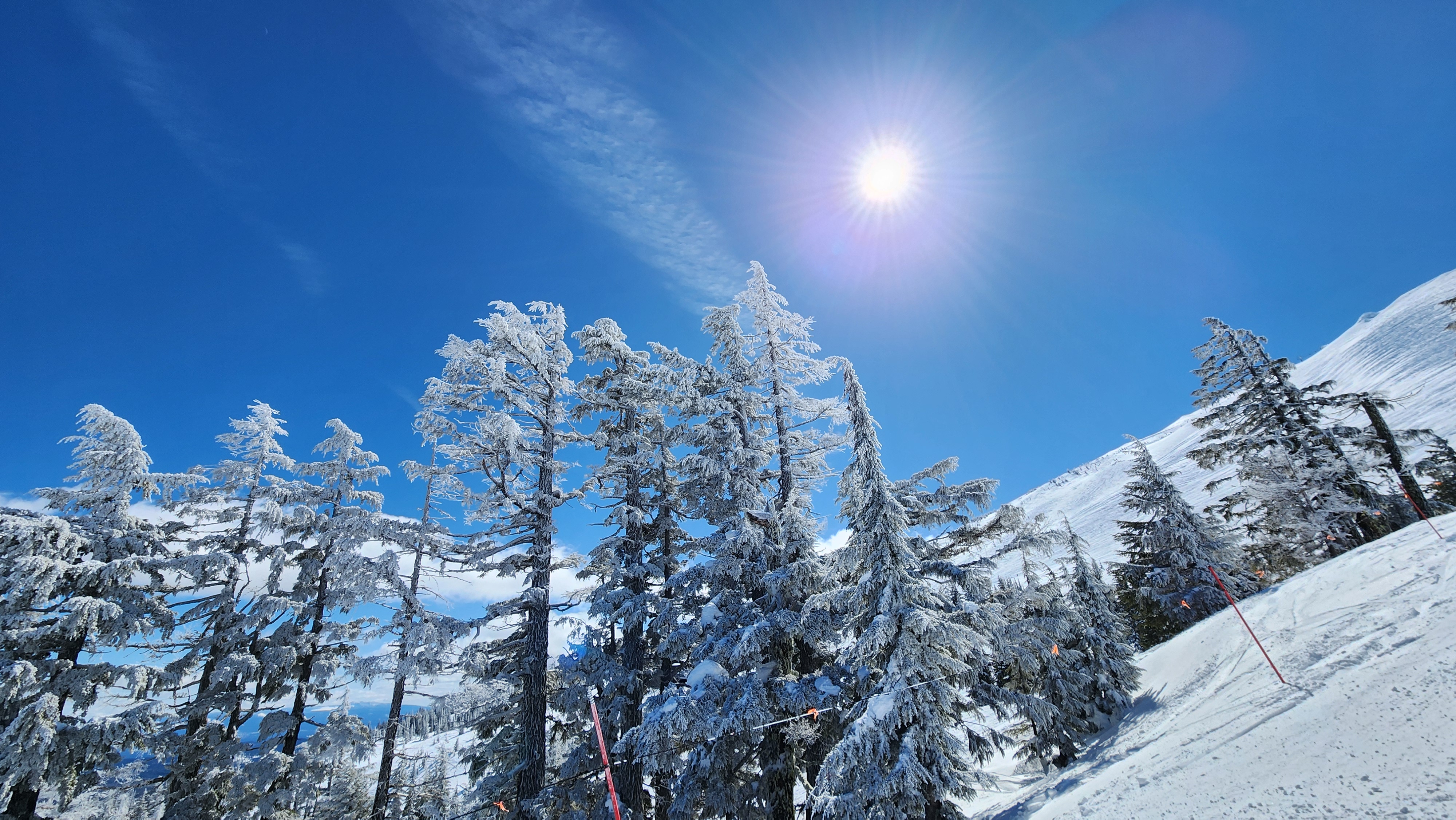
| Snow-flocked trees |
Instead Kim and I enjoyed a delightful afternoon, enjoying the lack of crowds, sunshine, and fluffy, powder snow. When skies are clear, skiers are treated to amazing views of the adjacent Cascade peaks surrounding Mt. Bachelor. I soaked in the wonderful mountain panoramas and tried to snap images with my phone. (For obvious reasons, I don't ski with any of my "big girl" cameras.) When Kim grew tired, she decided to quit early and rest at the bar. Having a bit more energy still, I opted to take a few more runs before also hanging it up for the day.
 |
| Lovely scene under the Outback Lift |
I headed over to the slopes underneath the Outback Lift, one of my favorite places to ski at Mt. Bachelor. Located on the shadier, colder side of the mountain, snow was still firmly stuck to the trees here. It looked like I was skiing through a bunch of flocked Christmas trees. So pretty! A great way to end another fun day.
 |
| Could almost see the adjacent mountains |
The third day at Mt. Bachelor, Kim was feeling sore and needed to rest. No problem - my brother Dale, who lives in the nearby town of Bend, decided to join me.
 |
| One day I skied with my brother |
The forecast called for clear skies and temperatures still cold enough to preserve the snow. Yeah! I was excited for another day of good conditions. But what I hadn't bargained on was the wind. It was absolutely howling.
 |
| Interesting clouds |
Although I had a great time skiing with my brother and catching up on his life, the strong wind definitely put a damper on things. Riding the chairlift was a mighty cold experience. (And during strong winds the resort runs the lifts slower than normal, so the uphill ride takes even longer!)
 |
| The Viking lifty was back! |
Our fourth and final day at Mt. Bachelor dawned sunny and warm. But that pesky wind was still blowing strongly. Oh well, at least it wasn't as cold as the previous day.
 |
| Keeping those skiers in line |
The warm sunshine, and the fact it was Friday, brought the skiers out in droves. After enjoying short, and sometimes nonexistent lift lines for the past three days, it was kind of a shock to have to wait in fairly long lines.
 |
| "Front row! C'mon out!" |
But luckily our favorite lifty was back! (For those who don't ski, "lifty" is what we skiers call the people who operate the chairlifts and manage the crowds trying to access them.) There is one man who works at Mt. Bachelor that dresses up as a Viking on warmer days. To our delight, Kim and I spotted the Viking that morning while in the lift line.
 |
| Someone drew the Mt. Bachelor logo in the snow under the lift |
Not only was this guy dressed to the nines in full Viking attire, he also was so enthusiastic about his job, you couldn't help but smile along with him. As skiers passed by, the man dished out high fives, and happily posed for photos. I happened to notice his name tag even said "Viking."
Another fun thing to see - as Kim and I sat down on the chairlift and it began its uphill journey, we noticed someone had stomped out the Mt. Bachelor logo into the snow below us. I tried to snap a photo of the good work, but in case you can't quite make it out, I posted a copy of the real Mt. Bachelor logo above for comparison.
 |
| Enjoying our ride |
By afternoon, the temperatures had risen well above freezing. In areas out of the wind, it was quite warm. The snow began to soften up, destroying the nice fluffy powder I'd enjoyed the previous days. Kim and I both agreed if not for the wind keeping things relatively cool, the snow would be too sticky to ski on.
 |
| Kim soaks up the sun |
Tired from multiple days of skiing, Kim and I threw in the towel early the afternoon of our last day. Enjoying a burger and beer in the lodge, we were entertained by a group of people doing a "shot ski." This zany tradition is rumored to be practiced at most ski areas. It's where multiple shot glasses are adhered to a ski and several people get together to tip the ski in unison and drink from these shot glasses. I'd always heard of shot skis, but until today had never seen a group actually drink from one.
 |
| Shot ski later in the lodge |
Having had a midweek season pass to Mt. Bachelor last year, which I used a record 17 times, five days this season was not nearly enough. Kim and I both agreed that while it was fun to try out the IKON pass and visit some favorite resorts, we're going to skip the IKON pass next season and go back to buying a midweek season pass here at Bachelor. It's one of our favorite resorts and we really missed coming here.
But at least we had a good time this week and made the most of the IKON pass days we had. Until next season, Mt. Bachelor!