Tuesday, August 12, 2014

Summer Rose

Here in Portland we've been having an unseasonably warm summer.  Temps have soared into the 90s for days on end, and we've hardly had a drop of rain since late June.  Although dry summer months are common here in the PNW (our reward for enduring the fall/winter/spring rains) the hot temperatures are not.


Portlanders don't know what to with so much sunshine.  We're used to cool, rainy, cloudy days.  Local lawns and flowers are taking a beating.  Nearly all our flowers have dried up (well.....forgetting to water them doesn't help....but normally we don't have to water very much!)

Luckily we have a few hardy rose bushes in our front yard that are still producing some lovely blooms.  My hubby discovered this gorgeous rose the other day.  Not only a creamy white, it's petals are tipped in a delicate shade of pink.  Nice to have something to brighten up our fried front yard!


Linking to:  Our World Tuesday.

Saturday, August 9, 2014

McNeil Point Revisited

 If you wanna see wildflowers, there's usually no better place to find them than McNeil Point.


Last of the Cascade Lilies

A trip up McNeil Point has become an annual tradition.  Of all the places I visit, this trail takes top honors as most-hiked.  Located on Mt. Hood's northwest shoulder, this ridge packs lots of high alpine scenery and incredible wildflowers.


Climbing the steep trail to McNeil Pt

I joined up again with my friend John and his hiking buddies.  He gathered a group of seven happy trekkers, and we set out from the Top Spur trailhead one sunny July morning.


View break!

The route up to McNeil Point is always the same.  A half mile climb up the Top Spur Trail to it's junction with the PCT (Pacific Crest Trail) and Timberline Trail.  From there, our group contoured around Bald Mountain, to take in the amazing views of Mt. Hood's craggy west face.  Then, back to the Timberline Trail, for a nearly two mile trek before reaching the unofficial "scramble" trail up McNeil Point.


Resting in the meadow by McNeil Pt shelter

Hidden in the thick vegetation is a route directly up a steep, rocky cliff.  Only a half mile in length, it's a great shortcut to the McNeil Point shelter.  But hikers beware - it's a leg-burning, lung-busting doozy of a climb!


Mt Hood towers above the meadow

When hiking a steep trail, I find taking photos as I go is the perfect way to sneak in rest breaks.  I hung at the back of the pack so I could stop and snap whenever a lovely scene inspired me. 


All paths lead to the shelter

Panting, sweating, sometimes grabbing rocks to pull myself up, I slowly made progress.  Good thing the views were so wonderful, otherwise I wouldn't put myself through such a tough slog!  As I got higher, the horizon broadened, until the entire Sandy River Valley lay before me.  White-topped peaks of Mt. Adams, Rainer, and St. Helens began to appear on the northern skyline.


Shelter backside

After what seemed an eternity, the cliff finally topped out, and I glimpsed the roof of the McNeil Point stone shelter.  I had arrived!  My friends were already relaxing in the nearby meadow.


Red paintbrush blooms

Three of the guys, John, Steve and Randy wanted to continue higher up the ridge another mile to a killer view of Mt. Hood.  Normally, I would've joined them, but today I just wanted to hang out in the meadow with my camera.  So I stayed put with the other members of our party.  We had a nice leisurely lunch, soaking in the wonderful alpine panorama.


More Hippies!

Adjacent to the stone shelter, the meadows here are known for their prolific wildflower displays.  Past years, I've seen the entire slope covered in a colorful kaleidoscope of lupine, paintbrush, heather, and Western Pasque flowers.  However, it appeared this year wasn't a banner one for flowers.  Only a few lupine and paintbrush blooms straggled above the greenery.


Dueling photographers

But luckily there were plenty of my favorite - Western Pasque flowers, or as I like to call them, "Hippy on a Stick."  I think their fluffy seed pods are really cute.


Making a snow angel

And there was also a snowfield nearby.   Perfect for cooling off with snowball fights, or making a snow angel!


Crossing a snowfield

After a wonderful relaxing hour, the men returned to the meadow.  Together once again, our group headed back down via the "official" trail.  Much gentler than the ridge scramble, this path traverses a stunning alpine meadow before heading down a high rocky ridge to rejoin the Timberline Trail.

But first we had to cross a snowfield.


Top of the world views

Down in the valley below, I spied two small ponds (or "tarns" as they are called).  Our return path would  pass by both these tiny water bodies.  But right now they looked so far away!


The incredible meadow wasn't as colorful this year

My group traversed a lovely green alpine meadow.  In years past, this area had been dazzling with an abundance of paintbrush and heather (check out last year's post).  But this year's flower show was disappointing.  Only a few meager patches of paintbrush, and even less heather, bothered to show their colors.  I guess you can't expect every year to be a banner bloom.   


Another snowfield crossing

But it was still a lovely place, and I enjoyed the wide-open views from on high.  And we got to cross another snowfield.


Avalanche lily

On the other side, was an enormous field of avalanche lilies.  These were almost as good as paintbrush and heather.


Traversing a talus slope

The group traversed a couple of rocky talus slopes that offered great views of the nearby mountains (although somewhat hidden behind clouds).


Flower-lined trails

And we passed by an area thick with lupine and orange paintbrush lining our trail.  (By then Terri realized sticking with me meant she'd be in lots of pictures!)


Mt. Hood watching over us hikers

Connecting with a rocky ridge, we began to climb downward, all the while paralleling lovely glacial-fed Ladd Creek.  Mt. Hood rose behind us, looking quite magnificent in the afternoon sun.


Ridgetop panorama

It was an amazing parade of forested ridgetops, mountain lakes, and blue skies that we enjoyed all the way down to the Timberline Trail.  A feast for the eyes!


Perfect Mt Hood reflection in a small pond

But the best was yet to come.  Remember those tarns I'd spotted high above?  Arriving at the first of the tiny ponds, I walked around to the very end.  From last year's visit, I remembered there was a perfect view of Mt. Hood reflected in the tarn's waters.  Today's reflection was absolutely terrific.  Seeing what I was up to, my friends wandered over and joined in the photo session.


Hiking buddies make good reflections too!

These still waters were not only good for mountain reflections.  I also caught a nice shot of my companions returning to the trail.


Beargrass and bug

Although it didn't have the wonderful reflections, the second tarn sported a nice field of beargrass.  The only blooms I'd seen all day, it warranted a quick photo break.  I was lucky enough to catch a small bee gathering pollen in one of the plumes.


Afternoon sun looks good on Hood

Then, it was a long trudge through the forest.  But before putting my camera away for the day, I made one final stop at the last clearing.  Afternoon sun lit Mt. Hood, her glaciers illuminated gleaming white.  A fine view of my favorite mountain, and a great way to end another perfect trip to McNeil Point.

Although the flowers weren't up to their usual standards, the wonderful alpine views, sunny skies, and great company more than made up for the lack of blooms.  Any day spent on Mt Hood is a great day!

Stats:  8 miles, 2200' elevation gain.

 Sharing with:  Weekly Top Shot and Weekend Reflections.

Monday, August 4, 2014

Summitting Coldwater Peak

My summer wildflower tour wouldn't be complete without a visit to Mt. St. Helens.  Beginning in mid-July, colorful flowers carpet the barren landscape around this mountain.  Some of the best floral displays occur along the Boundary Trail from the Johnston Ridge Visitor Center to Coldwater Peak.


Dewdrop-spangled lupine

For the past three years, I've driven the long two hours to follow this trail.  One of my very favorites, it's a "must-do" on my summer hiking list.  But although coming close, I'd yet to summit Coldwater Peak.  A long hike, (nearly 13 miles) both prior visits I'd run out of time, and had to stop short of the goal.


The paintbrush are out in force!

Two weeks ago, I decided today was the day.  I rallied my friends Young and John, enticing them with glowing descriptions of the beautiful landscapes.  We arrived at the Johnston Ridge Visitor center to chilly temps and thick clouds.  Not exactly the conditions I'd hoped for, but at least it wasn't raining!


Furry friend

My friends and I started out on the Boundary Trail from the visitor center parking lot.  The parade of flowers began almost immediately.  Although there wasn't the large purple carpets of penstemon like last year, lupine and paintbrush almost made up for the deficit.  Plus, many of the lupine's petals were drenched in dew droplets, which made for some fine photo ops.


Entering Devil's Elbow

For the first two miles, our path ambled downhill across desolate plains scoured by Mt. St. Helen's 1980 eruption.  When the volcano exploded, this area took a direct hit.  But bright patches of vivid orange paintbrush and deep purple lupine brightened an otherwise stark landscape.


Young traverses Devil's Elbow

At the two mile mark, the trail abruptly changes direction and follows a ridge southward around a gravelly plateau.  The trail across this ridge is narrow, with steep slopes above and cliffs below.  Dubbed the "Devil's Elbow," it's not for the faint of heart.

But there is a reward for this treacherous traverse.  Reaching the plateau's point gives visitors wonderful up-close views into MSH's collapsed crater.  Sadly, there were no views today.  MSH decided to be shy, and hid behind thick clouds.


First glimpse of Spirit Lake

But this plateau offered other views, almost as nice.  Looking to the east, my friends and I glimpsed the southern end of Spirit Lake, and above it the treeless slopes of Windy Ridge.


Wildflower-lined trail

Then it was back on the trail, winding through a lovely flower-strewn gully.  This section had a small spring flowing through it's center, and all sorts of green vegetation had taken root here.  Some of the trees and brush were almost tall enough to offer a little shade (if there would've been sun!)


Heading up the ridge above Harry's Saddle

Then my friends and I climbed up a hot, dusty path to a low point between two ridges, named "Harry's Saddle."  This feature's namesake was none other than Harry Truman, a crotchety old man who ran a resort on Spirit Lake, and famously refused to evacuate before the 1980 eruption.  When the mountain blew, he and his 40 cats perished.


Incredible views of Spirit Lake

From Harry's Saddle our trail began to climb.  We trudged up a steep ridge, amongst more barren landscapes.  Weathered old logs and stumps littered the hillsides, ghostly remnants of a pre-eruption forest.

Although the scene in front was barren, all one had to do was glimpse behind for some amazing views of brilliant blue Spirit Lake.  The higher we climbed, the better the scenery.


Young finds some wild strawberries

Lots of low shrubs covered the hillsides.  Amongst the greenery, eagle-eye Young spotted a bunch of ripe wild strawberries.  Although smaller than their domesticated cousins, these tiny berries packed a huge punch of sweet flavor.


Yummy wild strawberries

Mmmmm good!  Young and I could've picked berries all day.  But John reminded us if we wanted to reach the top of Coldwater Peak, we needed to keep moving .


Dead trees from the eruption litter the slopes

More elevation gain, climbing the ridge through ghostly gray tree stumps.  Although the cloud layer lifted slightly, revealing more of the surrounding hills, MSH remained firmly hidden.


Walking through the ghost trees

Reaching the ridgetop, my friends and I were greeted with a new panorama.  Round, ultra-blue St. Helens Lake sat far below, while the peaks of Mt. Margaret wilderness popped above the eastern sky.  Flowers again began to line our path.  We dipped down a steep slope and walked through a unique rocky arch.


Photo op at rock arch

Looking at our watches, I was surprised to discover it was well past 1:30.  No wonder my stomach was grumbling!  Hoping we'd soon stop for lunch, I was a little disappointed when John suggested we push on to Coldwater Peak's summit and eat there.


Contouring around St. Helens Lake

Still over a mile from our day's goal, my enthusiasm for summitting began to wane.  Not only ready for some nourishment, I was also worried we'd end up finishing the hike at a really late hour.  But John and Young were set on reaching the peak's top, so I reluctantly followed their lead.


Coldwater Peak summit is in sight!

The trail contoured around the side of St. Helens Lake.  Lupine grew in great abundance, and before long we'd climbed high enough to get glimpses of Spirit Lake, over the ridge from St. Helens Lake.

We hit a junction, and then the climbing began in earnest.  Ascending 700 feet in a mere 0.6 of a mile, this was a sweaty slog.  And, looking towards the summit, I was disappointed to see it cloaked under a thick bank of fog.


Nice lunch spot

But, after what seemed an eternity, like ghosts out of a cloud, the summit's radio towers came into view.  Yahoo!  John found us a nice perch on the rocks, and we settled in to a well-earned lunch break.

Although there were no views to enjoy, I was still happy to be sitting on top of Coldwater Peak.  After two tries, I'd finally made it!  Now that the climbing was done, I was glad my friends had pushed me into completing this goal.


Flowers line the summit trail

But the afternoon was getting late.  Bellies full, and legs rested, it was time to head back.  The romp back down was a pure delight.  Numerous flowers bloomed thickly along Coldwater Peak's lush green slopes.  On the way up, I'd been too preoccupied with reaching the summit to stop and photograph anything.  But nothing was stopping me now.


Western Pasque Flowers (aka "Hippy on a Stick")

Some of my favorite blooms were the shaggy seed pods of the Western Pasque Flowers, or as I like to call them, "Hippy on a Stick."


Shades of pink and blue

These ultra-pink flowers (sorry, have no idea of the name) contrasted great with the bright blue waters of St. Helens Lake.  As I descended, the fog began to lift, offering tantalizing peeks of the landscape below.


Colorful lupine

The lupine here was gorgeous.  It came in several different shades of purple.  I've never seen different colors within the same plant.


Heading back to Harry's Saddle and Spirit Lake

After lots of camera clicks, we reached the main trail again.  From here, it was a quick romp back around St. Helens Lake, through the rock arch, and down the treeless slope back to Harry's Saddle.


Walking across a moonscape

Returning across the sandy plains, we again trekked around Devil's Elbow.  Only two miles left from here!  But I'd forgotten that the final stretch back to the visitor's center was uphill.  After nearly 11 miles, and over 2000 feet of climbing at that point, to our tired bodies this final leg seemed to go on forever.


Colorful flowers brighten the trailhead

After a long day's hike, there's no sweeter sight than glimpsing your vehicle in the trailhead parking lot.  (Especially if said vehicle contains post-hike goodies of microbrews and kettle chips!)  My friends and I cracked open some cold ones, and toasted to another successful hike - and now summit bragging rights!

Stats for the day:  13 miles traveled, 3000' total elevation gain.  Another year's visit checked off the list.

Sharing with:  Our World Tuesday and Wednesday Around the World

Tuesday, July 29, 2014

Silver Star Mountain

For the past four years, I've been trying to get back and hike Silver Star Mountain.  A 2010 hike on the famed Ed's Trail was so fantastic, it left me eager for a revisit.  But busy summers, a horrible entrance road, and other matters (such as getting lost trying to find the trailhead one year) kept me away.


Ready to hike!

Finally, two weeks ago, I hatched a plan.  Offering to take a vacation day, I convinced my friend John to rally his retired hiking friends for a mid-week ramble up Ed's Trail.  John didn't take much arm-twisting!  He gathered a group of five wonderful people and we picked a day that promised sunny weather.


Fog bank below the trail

Ed's Trail is one of the premiere summer wildflower hikes in Southwestern Washington.  Traveling along a treeless ridge, flowers bloom thick in mid-July.  And the views can't be beat!  In 1902 this entire area was charred in the Yacolt Burn, the largest wildfire in Washington state history (well, until this summer).  Trees failed to reseed here, which opened the landscape up for wildflowers to flourish.


Mt. Rainer and Adams make appearances

However, admission to this wonderful trail requires a slow slog over a terrible gravel road.  I'd heard reports this road had deteriorated so much it was barely passable for cars.  Putting John's Subaru to the test, we soon discovered this was indeed true.  Lurching through gigantic potholes, my friends and I often wondered if the car was going to make it (we did scrape bottom a couple of times).  But, to everyone's relief, John's expert driving skills got us to the fog-shrouded trailhead in one piece.


Climbing through the yellow slopes

Although our trailhead was socked in, by the time we'd all unloaded, put on our boots, and taken last-minute potty breaks, blue sky was beginning to peek through the clouds.  Climbing the first quarter mile took us out of the fog for good.


Incredible St Helens view

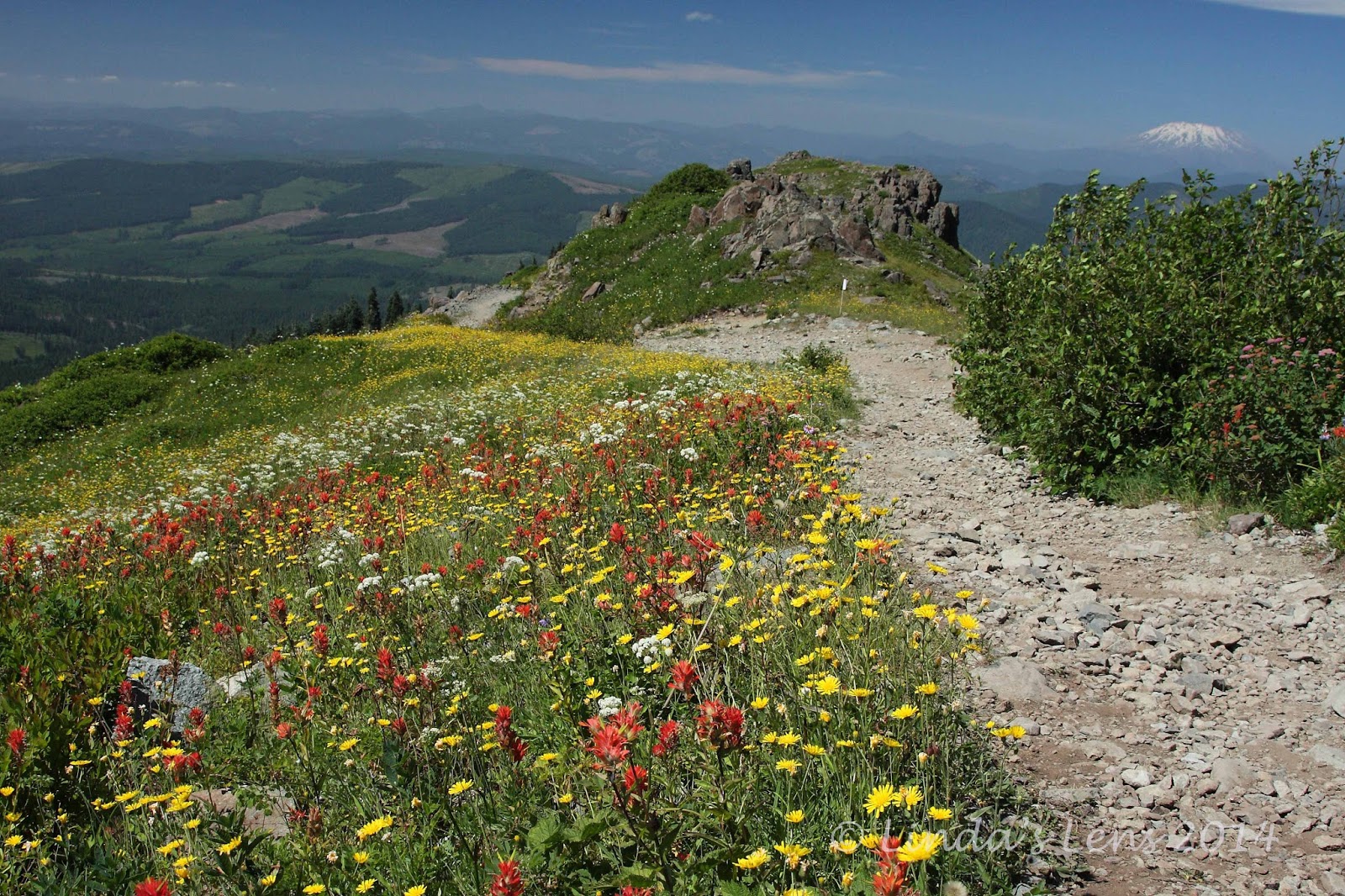
And - oh the views!  They were fabulous from the get-go.  A lingering fog bank hung in the valleys, creating a surreal scene.  From the first vantage point, three snow-capped mountains - St. Helens, Rainer, and Adams poked their peaks above the clouds.  A kaleidoscope of wildflowers provided the perfect foreground.


My favorite image of the day

This shot of Mt. St. Helens rising above the foggy valley was hands-down my favorite image of the day.

The group contoured along the ridgeline, past fields yellow with a zillion flowers.  The "big three" mountains continued to anchor the horizon, creating perfect photo ops.  It was hard not to stop and photograph the changing scenes every five minutes.


Group photo op at rock arch

One of the cool things about Ed's Trail is it passes through a natural rock arch.  That's something you don't see every day.  Perfect place for a group photo!


John in mid-climb

Then comes the fun part - a small climb up a short, rocky slope.  It required using both hands and feet to traverse.  But it was worse than it looked, and I had an easy scramble.  Kind of fun to mix things up a little bit!


Three peak view - St. Helens, Rainer, Adams

And upon reaching the top, you're rewarded with views like this.  The forested hills drop away on all sides, revealing a three-peak panorama.


Silver Star summit

Reaching a trail junction with an abandoned road, our party climbed the final half mile to Silver Star Mountain's bare, rocky summit.


Summit views

Clear sunny skies, meant 360 degree views.  You could see all the Cascade Peaks - not only the "big three" we'd been seeing all morning, Mt. Hood made an appearance on the southern skyline.  And if you looked hard, one could spot the white pointy tip of Mt. Jefferson.


More summit views

My companions and I settled down on the concrete foundation of a long-ago lookout tower and enjoyed lunch with a view.


Wide open vistas below the summit

After a nice break, John rallied the group to continue.  He wanted to hike a mile south of Silver Star's summit to visit the ancient Indian pits.  So down the mountain's steep, flower-filled slope we plunged.


Butterfly poses for me

The flower fields were full of butterflies.  Try as I might, I wasn't able to catch one of these beautiful insects at rest.  Then, finally John spotted a lone butterfly clinging to a flower.  It held still just long enough for me to fire off a half dozen shots.  Luckily, one of them did turn out.


Heading to the Indian pits

Our trail roller-coastered down one ridge, and up another.  Mt. Hood began to dominate the skyline.


Onto a rocky ridge

Then our group came upon a rocky talus slope.  It jutted out to a point.  With the land falling away on three sides, we again were treated to more wonderful views of the surrounding hills and forests.


John has a meditative moment

A line of rocky pits, each about six feet deep, had been constructed along the top of this ridge.  It's thought that these stone walls and depressions were built to be used as vision quest sites where young Indian men fasted until they saw a guiding spirit.

John sat down in one of these pits, and had a contemplative moment.


Relaxing in the rocky pit (photo by John)

I, too, climbed inside and briefly rested my tired legs.  But those rocks didn't make the most comfortable of seats, so I didn't linger.  Those Indian men were a lot tougher than weenie old me!


Nice views on the return trip

Then it was time to retrace our steps, back across the rocky ridge, past more incredible views and flower gardens.


Wide open ridge

Again, I really loved the wide-open views here.  So glad to have visited on a clear day!


Climbing through the flowers

My party climbed back up the flower-spangled side of Silver Star Mountain.


Another butterfly supermodel

Where I made another winged friend.  This one posed for a long time!


Wildflower central

Then came the cherry on top.  For the final leg of our journey, John led us down another abandoned road that wound through a spectacular field chock-full of wildflowers.  This was by far the day's best floral display!


Flowers and MSH view - it doesn't get any better!

The surrounding meadows were a colored bright shade of yellow as far as the eye could see.  And popping up over the horizon was none other than Mt. St. Helens, the day's constant companion.  Oh my - views just don't get any better than this!


Flower-lined trail

I spent way too much time in the meadow with my camera, and before I knew it, my friends had abandoned me.  Since the trailhead was only a couple of miles away, they continued on, knowing I'd eventually catch up.

Wandering along the road, I must've snapped over a hundred photos.  Around every bend were more colorful flowers, and another new perspective of the mountain scenery.  Finally, having had too much of a good thing, I began to get picky, and would only stop for the truly outstanding scenery.


Time for beer!

Back at the trailhead, everyone agreed it had been one stellar day.  Yes, Ed's Trail is definitely a crown jewel of PNW hiking trails.  Totally worth burning a vacation day to visit!


Sharing with:  Our World Tuesday and Weekly Top Shot.