
Showing posts with label penstemon. Show all posts

Monday, August 15, 2016

Ape Canyon

Ape Canyon, eh?

Ok, show of hands - how many of you clicked on this post hoping to see some apes?


Thick forest

Sorry to disappoint, but Ape Canyon doesn't house any primates (although I wouldn't rule out an occasional Sasquatch).  This starkly beautiful canyon got its name back in 1924 when an ape-like creature threw rocks at two miners in a nearby cabin.  (Years later an old-timer confessed that he and another boy were behind this prank)


Fog amongst the trees

Ape Canyon is one of the few valleys on Mt. St. Helen's south flank that were spared by the 1980 eruption.  When the mountain's north side blew, the heat instantly melted all its glaciers.  The resulting large volume of water created a huge mudflow that rocketed down St. Helen's slopes, obliterating everything in its path.  But Ape Canyon somehow managed to avoid the destruction, and today boasts a lovely trail that winds through an ancient old-growth forest.


MSH is shy

It's been an exceptional year for wildflowers around Mt St Helens.  Penstemon has been carpeting the adjacent hillsides in a deep shade of purple, and it's been the best paintbrush bloom in many years.  In mid-July the Portlandhikers and Oregon wildflowers websites were both posting reports of an amazing flower show in the Plains of Abraham, above Ape Canyon.  Of course I wasn't about to miss it!
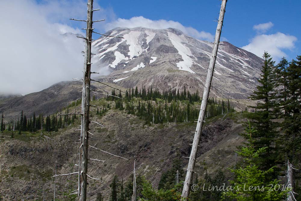

The mountain is out!

So early one July Sunday morning had me pointing my car towards the Ape Canyon trailhead.  It had been years since I'd hiked this trail, and I nearly drove right past the parking lot.  But after overshooting and ending up at the Lava Canyon trailhead, I found my way back to the right spot.


Vibrant orange paintbrush

A sign at the trailhead warned of a recent cougar sighting.  It advised hikers to travel in groups and make noise.  As I was by myself, I started out cautiously, whistling and clacking my poles.  Then I got passed by a group of mountain bikers....and another.....and another.  After the fifth band of bikers passed me by, I quit the noisy routine.  I figured all those bikers would scare away any predators!


Looking back down Ape Canyon

The trail up Ape Canyon began beside a cliff overlooking the Muddy River's vast lahar.  It resembled a moonscape of gray rock.  This lahar was created when the 1980 eruption melted the Shoestring Glacier, unleashing a torrent of mud, rock and ash. 


MSH's south side

The morning was cold and cloudy, low-lying fog obliterating any views of the famous volcano.  But my trail was through untouched forest, passing some lovely, mossy old-growth Douglas Firs.  The climb was steady, ascending 1300 feet in five miles.  There wasn't much for views, so I trudged along, listening for bikers, and enjoying the lush forest.


Path through the wildflowers

Near mile four, the forest started to thin, and I began to spot glimpses of the lahar's rocky slopes between the trees.  Then I spied Mt St Helen's wide base slowly emerging from the clouds.  Would the fog lift by the time I left the forest?


Dramatic mountain view

The answer was yes!  By the time I approached the Loowit Trail junction, blue sky had replaced white fog, and MSH was showing her glorious self.


Finally the Loowit Trail!

After five miles slogging uphill through the forest the Loowit Trail was a welcome sight.  Circling the entire mountain, the Loowit provided hikers with magnificent views of the truncated volcano and crossed barren plains, decimated by the 1980 eruption.


Sea of purple

My plan was to follow the Loowit Trail north, towards the Plains of Abraham.  About a mile away, the flower show was supposed to be going strong.


Mountain biker

After a quick snack, I continued my journey via the Loowit.  MSH rose above the desolate plains, her shrinking summer glaciers like white stripes down her sides.  More mountain bikers rolled by in both directions.  By this point, I'd seen more of them than hikers all day.


Purple carpet

I passed through a lovely lush valley, with a tiny trickling spring running through the middle.  Flowers sprung from the rocky pumice soil - lupine, paintbrush, yellow Oregon Sunshine, and gobs of purple penstemon.  Two tents were set up in the middle of the brush, and I thought to myself what a wonderful place for a basecamp.


Nice accent to the mountain

Beyond this spot of eden, the wildflower show began in earnest.  The rocky plains were covered with a purple carpet of penstemon.


Incredible penstemon bloom!

Oh it was magnificent!  I've never seen wildflowers in such high concentrations.


It just went on and on....

As you can imagine, it took me quite awhile to traverse the next half mile......


Close up of these lovelies

The flower show just kept on going.  Chatting with a few mountain bikers, I learned it extended past the trail to Windy Ridge, two miles away.  Although I would've loved to continue trekking northward, my gps already registered 6.5 miles.  The further I walked, the further I'd have to walk back.


Lone paintbrush

Finally, I forced myself to pack the camera away and head back the direction I'd come.


Color spot near a spring

Back through the flower fields adjacent to the spring....


Clearing skies

Climbing up the other side of the spring's lush little valley, I was passed by a couple of slow-walking trail runners.  They both looked extremely tired, and in conversation I learned they'd been running around the entire mountain via the Loowit Trail - nearly 29 miles!  Now nearly finished, one guy admitted they were deep in the "pain cave."


Wonderful bloom!

No pain cave yet for me, but my feet were getting a tiny bit tired.  But flower displays like this buoyed my spirits.


Most excellent camping spot

Nearing the junction with the Ape Canyon Trail, I looked out across the desolate moonscape.  Ape Canyon's green ridge stood out prominently amidst the gray pumice plain.  Sure looked out of place!


Ape Canyon is the green ridge

Reaching the Ape Canyon Trail, I was happy for a long stretch of sweet downhill.  However, knowing all those mountain bikers would likely return, I kept on high alert, straining my ears for any human sounds.  Luckily, all the bikers I met were very cautious and instantly slowed down the moment they spotted me.  (I've heard of conflicts between hikers and mountain bikers but all the riders I met on this trail were nothing but courteous)


Premature fall color

Eager to be done, I forced myself to march downhill as fast as my legs would carry me.  About halfway down, my energy flagging, I took a quick break and downed a peanut butter sandwich.  I happened to stop next to a huckleberry bush full of ripe berries - a perfect compliment to my peanut butter.


Old lahar path is starting to fill in

Nearing the trailhead, I began seeing glimpses of the Muddy River's vast debris plain.  Fogged in when I began in the early morning, I was now treated to some grand views of MSH and the wide river channel, slowly filling in with tiny trees.

Another wonderful wildflower trek!  I clocked in at 13 miles, nearly 1500 feet of elevation gain, and a memory card full of amazing floral color. 


Sharing with:  Through My Lens

Tuesday, July 5, 2016

Walking With A Friend From Down Under

One of the best parts of having a blog is getting to know other bloggers from all over the world.  After exchanging comments over time, you form online "friendships" with some of  the regulars.  And if you're really lucky, sometimes you even get to meet them in person.


Bloggers united!

In early June I had the pleasure of meeting Helen from Walking With Friends Down Under.


The flower show began right away

Helen traveled all the way from Brisbane, Australia just to see my little corner of the world (well, she happened to be visiting her son who lives in Banff, Alberta and decided to add a side trip to Oregon while she was "nearby").  Having followed her blog for a few years, I was thrilled to meet my Australian blogging pal.


Indian paintbrush dotted the hillsides

Like me, Helen's an avid hiker.  A regular reader of a few Pacific NW blogs, she already had a list of places on her "must visit" list.  One of them happened to be Mt. St. Helens.  One of my favorite spots, I was more than happy to show her around.


Vibrant orange paintbrush


Helen arrived in Portland in the middle of a beastly heat wave.  Temps the day before had reached into the 100s (or 38 degrees C for my Aussie friend).  Thankfully the day we'd chosen to visit MSH wasn't predicted to be quite that hot - however the weatherman still forecasted sunny, warm weather.


Then came the purple penstemon...

Despite the toasty temps, Helen chose a great time to see the famous volcano - 1.  the hot weather guaranteed clear blue skies, so we'd see the mountain for sure (no hiding behind clouds, as it sometimes does in the spring), and  - 2.  our warmer-than-normal spring meant the wildflowers were blooming early.


It's a banner year for penstemon too!

I picked Helen up at her motel bright and early.  We filled the long two-hour drive with great conversation.  Before I knew it, we were catching our first glimpse of MSH's truncated top.


Purple everywhere

After a quick potty break at Coldwater Lake, we arrived at Johnston Ridge Visitor Center.  The flower show began right away.  Before we even started hiking, Helen and I were whipping out our cameras to get some shots from the parking lot.


Heading out onto Devils Elbow

We began our trek on the Boundary Trail.  Wildflowers were abundant from the very start, with vivid orange Indian Paintbrush and lovely purple penstemon decorating the surrounding plain.  I'd never seen so much paintbrush and penstemon blooming - and so early in the season!  Needless to say, between the wildflowers and killer volcano views, our first mile wasn't very speedy.


The narrow path across Devils Elbow

But Helen and I found our groove, and soon we were approaching the infamous "Devil's Elbow" - a portion of the Boundary Trail that traverses the side of a steep cliff out to the tip of a pennisula.  The trail is narrow with a bit of exposure.  But Helen, not fazed in the least, marched right across.


Best viewpoint yet!

Our reward for traversing this perilous path?  Amazing in-your-face views of St Helens herself!


Crater close-up

We gazed at MSH's ravaged north side.  When the mountain exploded back in 1980, the blast traveled across the plains where we now stood, leveling everything in its path.  Although small plants and shrubs have since reestablished, larger trees have been slow to take root.  The area immediately north of the mountain still resembles a barren wasteland.


Great view of the blast zone

After soaking in the views and memorializing with countless photos, Helen and I continued our journey across a desolate plain sprinkled with colorful spots of flowers.


Flowers brighten the wasteland

Our goal for today was Harry's Ridge, site of a former lodge owned by a crotchety old man named Harry Truman.  Back in 1980, although an eruption was imminent, Harry refused to evacuate, and died in the blast.


Sheared off trees from the eruption

As we climbed up the base of Harry's Ridge, Helen and I passed by weathered stumps of old trees, sheared off by the blast's tremendous force.  A sobering example of this natural disaster's enormity.


First view of Spirit Lake

Reaching the base of Harry's Ridge my friend and I peered over the edge for a jaw-dropping view of Spirit Lake.  White-topped Mt. Adams anchored the skyline, and Helen gazed in awe.  As many times as I've seen this sight, it still thrills me too.


Climbing Harry's Ridge

Then it was a hot, dusty trek along Harry's Ridge to its terminus and another wonderful view of MSH.


Panorama included Spirit Lake and Mt. Adams

A perfect lunch spot!  Helen and I spread out our food and enjoyed a well-earned break while taking in the 180 degree panorama of sights.  Not only Mt St Helens, we had a killer view of Spirit Lake, Mt. Adams, and even a ghostly Mt Hood on the far horizon.


And up close and personal MSH views

We chatted with a friendly couple from Montreal, and the man was nice enough to snap a few photos.


Heading back down Harry's Ridge

Bellies now full, it was time to retrace our steps to the Visitor's Center.  Back down Harry's Ridge, again taking in the marvelous views of Spirit Lake, Coldwater Peak, and the surrounding Mt. Margaret backcountry.


MSH is always in view

Then across the plains of flowers and low bushes, with MSH anchoring our view.


Our last look at Spirit Lake

We made a brief stop at the tip of Devil's Elbow Peninsula, for one final glimpse of Spirit Lake and Mt. Adams.


Helen bids Mt. Adams goodbye

It was here Helen bid Mt. Adams goodbye.


Dark purple lupine

Then back across the sketchy trail along Devil's Elbow and it's steep slope, where I discovered this patch of deep purple lupine just begging to be photographed.


How to capture this marvelous field of paintbrush?

When wildflowers are in bloom, I never mind hiking the Boundary Trail twice.  Helen and I passed by vast fields of paintbrush and penstemon.  How does one capture such beauty?


Back past the purple carpet

Although by now we were both hot and tired, neither one of us could resist a few last photo stops.  The flowers were so amazing, I wanted to be sure not to miss a thing!


Penstemon as far as the eye can see

As we neared the visitor center, the crowds thickened until the last half mile we were passing hordes of people.  Having had most of the trail to ourselves, it was hard to adjust to all this humanity. 


My calendar shot

As wonderful as this hike had been, I was still very happy when my car came into view.  I'd placed two water bottles in a cooler - and the cold water tasted heavenly after such a hot trek.  We took a quick trip through the visitor center, but time was getting late, and we both needed to get back to Portland.  However, I had so much fun hanging out with Helen, I wished the day wouldn't have to end. 


Enjoyed the journey, Helen!

So nice to meet and share a hike with one of my blogging buddies!  As we parted ways, I promised Helen I'd save my pennies for a future visit down south.  It's my turn to hike one of her favorite trails!


Stats:  8.5 miles round trip (about 14 km) and 1000 feet (300 meters) elevation gain.

Read Helen's recap of our day here.