
Showing posts with label iris. Show all posts

Monday, August 19, 2019

In Search of the White Iris

With so many fantastic hiking trails within a 2-hour drive of Portland, people may wonder how I choose my weekend destinations.  Throughout the week, I monitor several hiking websites and Facebook pages.  When these sites point out flowers that are blooming or other unique happenings, that's where I go.

Such was the case on the final weekend of May.  Memorial Day weekend meant three days of hiking.  After getting skunked on Dog Mountain (heavy clouds, rain and wind drove me from the summit) on Friday, and scaling Nick Eaton Ridge on the other side of the Gorge Saturday, I was ready for a short, mellow trek on Sunday.


Glowing green forest

Someone on the Oregon wildflowers Facebook page posted photos of white irises, growing wild along the Clackamas River.  Having come across lots of purple irises over the years, I'd never before encountered one that was white.  Totally intrigued, I had to check it out.  So I recruited my friends Debbie and Barry to join me for a Sunday romp along the Riverside Trail.


First iris found - within five minutes!

Although skies threatened rain that morning, by the time my friends and I located our trailhead parking area, things had dried out.  Donning boots and backpacks, we tromped around looking for the actual trail beginning.  Finding it on the far side of the lot, we quickly descended into a fairy-tale, glowing green forest.


Gigantic old-growth tree

A short quarter mile brought us to the trail sign proper.  As I was snapping some pics of  Debbie and Barry posing by the sign, I spotted a few white shapes in the green vegetation below.  Irises!  Well, that didn't take long.


Trying to keep up with my friends

Debbie joked now that I'd located my coveted flower, it was time to go home.  But a stunning, mossy old growth forest awaited, full of huge trees, ferns and more wildflowers.  There was no way we were turning around!


More tall trees

Down through the forest our hiking party traveled.  We passed a grove of gigantic fir and cedar trees. 


Lovely moss covered everything

We then wound through an extremely mossy forest, covered head to toe (or treetop to forest floor) with bright green, fuzzy moss and wispy lichen.


Sturdy bridge

Crossing a sturdy wooden bridge that spanned a side creek, I got so busy taking photos I had to hurry to keep up with my friends.
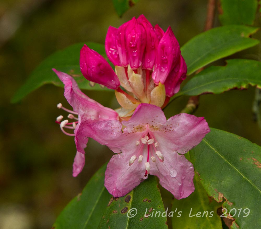

First rhodie blooms

Further up the trail, I spotted the first rhododendron bloom of the season.


Passing by another large grove

We passed by another area of enormous fir trees, these even larger than the ones near our trailhead.


Even the trail sign had greenery!

Even the trail sign had lichen growing on it!


Fern-lined trail

Near the trail's midpoint, my friends discovered another large patch of white irises.  Much photography ensued (mostly by me).


More white iris!

Then it was onward, through more amazing forest scenery.  Although I'd hiked this very trail several years ago, I had forgotten how beautiful these old growth forests could be.


Nearing a river view

Although the Clackamas River was never far away, thick vegetation and tall trees prevented any glimpses of the water.  That is until we neared the Rainbow Campground, the day's turn around point. 


Clackamas River sighting

Several gaps in the forest provided our first peek-a-boo river views.


An unused campsite makes a perfect lunch spot

Finding the perfect spot to sit and have lunch is always challenging on a hike.  Lucky for my friends and I once we made it to the Rainbow Campground, not only were there fantastic river views, we also scored a picnic table at an unused campsite.  Excellent!


Waters of the Clackamas were crystal clear

The mighty Clackamas River was flowing swiftly, right next to our picnic table.  I couldn't resist capturing its crystal-clear waters and colorful rocky bottom.


Huge, mossy nurse log

Tummies full, it was time to retrace our steps back through this wild, green wonderland.


Huge, mossy live tree!

The trail was so gorgeous, none of us minded seeing it twice.


Wooden boardwalk through a swampy area

Passing through a swampy area, the trail builders had constructed a nice wooden boardwalk to keep hikers from getting muddy feet.  I loved the prolific ferns lining the walkway.


My friends pose on the bridge

A pic of my friends posing on the bridge.  And nearing the end of our day's journey, I snapped a few more photos of the same white iris as we passed back by the trail sign.  Knowing how rare these flowers were, I wanted to get as many images as possible.


Final white iris of the day

Whatever the reason, whether it's to see unusual flowers, take in the grandeur of huge old-growth trees, or lose yourself in a green, mossy wonderland, there's nothing better than a spring day spent in the forest.  My friends and I managed to escape the rain (just in time!) and headed back to Portland for dinner and brews at a local pub.

Thanks Debbie and Barry for a fantastic day!

(Hike 22 done!  #52hikechallenge)

Sunday, June 30, 2019

Foggy Southern Oregon Coast

Fog ruled the weekend.

In early May, I scheduled a repeat of last year's wonderful Southern Oregon coast trip, again traveling to Oregon's most SW corner, the border town of Brookings.


Harris Beach

After an insanely busy month at work, I was more than ready for a few days on the coast.  Driving down the highway, the stress melted away with each passing mile.  By the time I reached my yurt at Harris Beach State Park I'd nearly forgotten all my real life woes.


First night's sunset was a stunner

Upon arrival, of course the first order of business was to head for the beach!  I was more than ready for a spectacular ocean sunset.  And that night the skies delivered.


Sunset afterglow

Oh yeah, this was what I'd traveled here for!  Lingering on the beach after the sun had finally dropped watching waves crash against the rocks, I was totally relaxed.  Here for three days, I looked forward to more colorful evenings.


Second night's foggy sunset wasn't so great

Except.....that sunset was as colorful as things got.  On day two, driving back from my jet boat ride (read about it here), I hit a fog bank about 5 miles North of Brookings.  The state park, along with it's shoreline, were totally socked in.  Although I still went to the beach that evening, all I got was one quick burst of light before the sun sunk behind the clouds.


Meyers Beach

Day three, I awoke to fog and mist.  I'd planned to hike several short trails along the Samuel H. Boardman Scenic Corridor that were known for fantastic coastline views.  But the blah skies wouldn't make great photographs, so I headed north to see if I could escape the fog.  Nope.


Not much color

I finally ended up at Meyers Beach.  The sea stacks rising out of the clouds were kind of scenic and drew me in.  And there was a short 2-mile hike along the beach concluding with a quick climb up to Cape Sebastian.  Better than nothing.


Foggy hills above the beach

I followed Meyers Beach to its very north end, past tall sea stacks and wave-sculpted rocks.  I was totally by myself save for a small group of vultures congregating on a nearby hill (hmmm.....maybe that's not a good sign)


Deep purple wild iris

The beach dead-ended into a tall, sandy slope.  Someone had left a rope tethered into a few stakes to help hikers scramble uphill.  Although it looked kind of sketchy, I successfully hoisted myself up the steep section.  There was actually a trail on top, and it wandered through a thick coastal forest.


Cape Sebastian

Adventurous curiosity won out over caution, and I followed the trail as it climbed past a few patches of lovely purple iris.  It didn't take long before I came to a clearing.  A huge expanse of light-colored rock dropped off to the churning ocean below.  This must be Cape Sebastian!


Churning waves below Cape Sebastian

By now the fog had cleared enough to glimpse the ocean and  a few nearby sea stacks.  Considering the weather, I was happy for any views.


Selfie for the blog

I had a snack, snapped a quick selfie, and then retraced my steps back through the forest and down to the beach. 


Another lovely iris

One portion of the beach was a bit narrow and with the incoming tide, I was concerned about getting trapped.  That was my motivation not to linger too long on Cape Sebastian.  But no worries, although the tide had come in a bit, there was still plenty of sand to walk on.


Vultures

I passed by the vultures once again, and remembering the tips from my friend Cheri, tried to capture a few action shots.


Cape Sebastian from Meyers Beach

I took one final look back at the tree-lined cape in the fog before returning to my car.


Lovely unnamed cove off of the Boardman Scenic Corridor

Where to go next?  It was still extremely foggy.  But after traveling a long distance to be here I wasn't about to sit in my yurt.  Bad weather or not, I headed back to the Samuel Boardman Scenic Corridor. 


Oregon Coast Trail wound through here

Stopping at an unmarked pullout I'd noticed earlier I walked along a short portion of the Oregon Coast Trail to an overlook.  Below was a pretty cove, it's green-blue waters surrounded by lush cliffs.  Time to have a closer look.


The iris were thick!

I followed a rough user trail nearly all the way out to the point of the furthest rocky sea stack.  Along the way I passed fields of lovely purple iris.


Iris patch

The flowers were so thick here!  And one advantage to cloudy skies, it made the colors pop.


View from Thunder Cove

Moving on, I returned to my car and drove to the parking area for Thunder Cove.  One of my favorites from last year's trip, I followed a short trail to this breathtaking ocean viewpoint.  The rugged coastline stretched out before me with rows of seastacks.


Beautiful mossy coastal forest

Through photography forums I'd heard of a nearby place called Secret Beach.  It was supposed to be an especially lovely location to capture sunrise and sunsets.


Secret Beach

From Thunder Rock Cove, a primitive sign directed hikers to "the beach."  Tired from a long day of hiking, I'd skipped this trail last year and regretted it.  I wasn't going to miss out again.  Time for more exploration!


Sea stacks at Secret Beach

This steep, rooty trail dived downhill and wound through thick, mossy forest.  Parts of these woods were downright spooky.  I began to wonder if this was a good idea.


Fairy Bells

But after a long downhill trek (at least it seemed to take forever!) I came upon a clearing.  Perched on a rocky peninsula, it jutted out over the ocean.  About 10 feet straight below was a tiny beach lined with sea stacks.  It was indeed a pretty place.  However, I could see that I'd have to slide down a rocky slope to access.  Tired from my downhill trek, and seeing the incoming tide (and not wanting to get trapped) I decided to admire from above. (Later that evening, reading my guidebook, I found out that this isolated place was indeed Secret Beach.)


Thunder Rock Cove

On my way back, I made one final stop at the overlook to Thunder Rock Cove.  The series of wave-eroded arches always make good photo subjects (even on cloudy days!)


The fog cleared for a decent sunset

That night, I again headed down to Harris Beach for another sunset try.


Sinking through the cloud layers

Although a bit better than the previous night, I only got one brief flash of color before the sun hid below a band of low clouds.


Looking into China Beach

My final morning I had time for one quick hike before checkout.  I decided to hike down to China Beach, another scenic spot recommended by photographers.


Wild strawberry flower

Again, as with many of the trails along the Boardman Scenic Corridor, this beach trail is not signed, and I relied on vague directions from an online source.  From the parking area, right away I took the wrong trail and ended up on a clifftop looking down at the beach.


China Beach

The forest had a lot of primitive user trails, and I took one more dead end before finally getting on the right track.  The trail to China Beach wasn't very long, but I probably traveled double the distance just trying to find the correct trail.  And sadly, once I arrived, the foggy weather didn't really produce good light for photography.  Guess I'll have to try again on a sunny day.


Of course, the fog cleared as I was leaving!

Speaking of sun.......After packing my car for the day's trip north to Bandon I headed up Hwy 101.  Not 10 miles north of Brookings, the clouds suddenly cleared.  I could see blue sky again!  Of course the sun decided to come out on the day I was leaving.


Sea stack view from Arch Rock Pullout

But my trip wasn't over yet.  I planned to spend a night in Bandon, one of my favorite towns on the Oregon coast.  Surely these sunny skies would hold on for sunset photos.

Or would they?  Find out in my next post.....