Friday, June 8, 2012

Three Corner Rock - Mud and Fog

I'm fortunate to have a flexible work schedule, with every other Friday off.  These Fridays are regarded as "bonus days" and thus I make sure they're used for fun activities (no wasting them doing chores!).  This past Friday found me with a day off but no plans.  Time for a hike!


My well-worn hiking bible

As some of you know, my long-time goal is to hike all 100 hikes in William L. Sullivan's "100 Hikes in Northwest Oregon" book.  I bought his first edition back in 1994.  Although the book has been updated several times since then, I still use the original first printing as my guide.  Friday I consulted with my "hiking bible" for another hike I'd yet to complete.  Three Corner Rock popped to the top the list. 


The muddy road

The trailhead for this hike is located on the Washington side of the Gorge, near the town of Stevenson.  After crossing the Columbia River on the Bridge of the Gods, and turning off on a road that passed Skamania Lodge, Sullivan's directions led me to a long, winding gravel forest service road.  The trailhead was near a junction, 9.5 miles down this road.  At first, all was fine.  My Subaru Outback loves gravel roads, and easily churned through the thick layer of aggregate a road grader had just spread.  The road kept gaining elevation, sometimes rather steeply, but my car climbed it no problem.  The scenery was beautiful, and I had the place to myself.  All was right with the world.


Nice forest path


Then, about six miles later, my car encountered what I thought was another deep gravel layer.  I soon discovered it was not.  Attempting to climb through the muck, my Subie lost traction and started to slide, fishtailing as it struggled to regain a grip on the road. This wasn't gravel - it was mud!   Thick, sticky mud. Uh-oh!

Thanks to all-wheel drive, I powered through the boggy mess.  Thinking maybe this was an isolated incident, I continued on.  But no, around the next corner another mudpit awaited.  And another slip-n-slide to get through it.  This pattern continued for several more miles.    


The avalanche lilies were out in force!

I began to get worried.  There I was, all by myself, on an extremely muddy road. Not seeing anyplace to turn around, I had to keep going. I told myself "whatever you do, don't get stuck." I didn't have cell reception, and it was a long walk out.

But my Subie performed amazingly.  It muscled through that mud no problem.  I kept driving further down the road, hitting more and more deep pockets of slime.  But my car cut through it like butter.  It started to feel like I was in a Subaru commercial!  (Subaru, if you're reading this, give me a call)


Pretty bleeding hearts

I hit the 9.5 mile mark, but the junction was nowhere to be found.  I had to keep driving, as there wasn't anywhere to turn around (and I didn't want to get stuck trying!).  I must've driven another half mile at least, getting more and more worried, when I finally came upon the much-anticipated fork in the road.  Just a short half mile down a secondary gravel road - and there at last was the trailhead.  Yahoo!


Rain-speckled trillium

My car was the only vehicle in a small parking pullout.  The sky was thick with clouds, the fog rolling in.  It looked like it could rain at any minute.  Thinking of the boggy road I'd just driven to get here (and would have to drive again on the return trip) I realized more precip would likely make it impassible.  If it started raining, I'd probably be stuck.


Still snow on the trail

To hike or not to hike?  I thought long and hard. With so much time and effort expended to reach this point, it would be a shame to turn around and leave right away.  And I really wanted to check this hike off my list.  I finally shouldered my pack and started up the trail, promising myself to turn around if any rain began to fall.


My pup in the flowers

The trail began in a lovely forest, dressed in its best spring green.  Although the climbing began right away, the path was well-graded and never became too steep.  The wildflowers burst out of the forest floor from the get-go - frilly white avalanche lilies, trilliums, and deep pink bleeding hearts.


Amazing flower patch

 
But thick fog descended almost immediately, and didn't let up the entire way.  After a mile, I passed a side trail to what looked to be a viewpoint.   Sadly, there was nothing to see but white.


Foggy steps lead to the top

 
About a half mile from the spur trail to the summit, Bear and I encountered our first snowbank.  It's been a cold spring here in the PNW, and the snow has been slow to melt.  As I climbed closer to the summit, the snow patches became more numerous.


Views?  What views?

Finally, I reached an old road that would lead me to Three Corner Rock's summit.  The ancient track was a mixture of snow and deep, slimy mud.  Arrghhh!  Not mud again!  And this time I didn't have my Subie.  But we were too close to stop now, so Bear and I waded through the muck.


Nothing to see here

The top of the mountain was in a thick fog bank.  Landmarks were hard to discern, and it was a little difficult to determine Three Corner Rock's summit location.  Luckily, I had my map and guidebook, otherwise I think I'd have missed the trail.  I found the trail hewn through the rocks, and then steps concreted into a boulder field that got me within 12 feet of the summit proper.
 

The sky began clearing as I hiked back down

Hooray!  Success!  I scrambled the final 12 vertical feet to the very top of Three Corner Rock.  But my victory was for naught.  Due to the fog, there were no views to be had that day.  No reward for my climb through the forest, snow and mud.  I was left admiring the foundation blocks from a long-gone fire lookout tower. 


Love this ultra-green forest

So after a quick lunch break, and a couple of self portraits in the fog, Bear and I headed back down.  Following the foggy road, I almost missed the return trail turnoff.  If it wasn't for Bear starting down this path as I marched on by, I would've missed it entirely.  My dog is better than a gps!


One final trillium

Traveling back through the forest, I noticed the sky beginning to brighten.  The fog started to lift.  By the time I reached the viewpoint again, there was actually a view to see.  And it was some great scenery.  The forest stretched out for miles, and I could now see the distant green hills.  Too bad things couldn't have cleared off while I was sitting on top of Three Corner Rock.


Another hike checked off in the book!


I made my way back to the trailhead, where I discovered another car - a Prius of all things - parked next to my Subie.  And I thought, if a Prius can make it down that nasty, muddy, road I should have no trouble getting back out.  And I didn't.  But, boy did the bottom of my car get coated with mud!  Back at home, I spent the better part of 30 minutes spraying it out of my wheel wells.  Then it took another half hour just to clean all the mud off the driveway!

No matter, it was a good adventure.  And another hike to check off in my book.  I'll have to make a return trip someday, to see the views I missed.  But I think next time I'll wait for drier weather.  :)


Wednesday, June 6, 2012

Black & White


This is a teaser photo for my readers.  Last Sunday I had a most excellent hike on a trail paralleling the Oregon coast.  Most of the time I was on a bluff high above the ocean.  But at one point my path intersected with the beach.  Lots of great photo ops here, but this little sand dollar caught my eye.  I'll post a full trip report, complete with lots of photos, later in the week.  So stay tuned!

The reason you're seeing this photo today is I've decided to participate in the 52 Photos Project, a website for photographers to display their work.  The site provides a different shooting topic every week.  This week's theme is black and white.  I'm usually a color photo type of gal, but after converting my sand dollar shot to B & W, I found I really liked it sans color.  I hope you like it too. 

The full 52 Photos Project gallery can be found here.


Monday, June 4, 2012

Campin' Is....

Obviously I did more than just hike on my Memorial Day weekend campout.  There's lots of other things to do at the Cove Palisades State Park.  And when you're camping with others (my brother and his family) the fun is multiplied - especially if the group includes kids.  Nobody loves camping more than children.

Camping encompasses many activities.  It means different things to different people  - from the comforts of a motorhome to the bare necessities of backpacking.   But here is a sample of what campin' was for me last weekend.


Size matters!  Click on any photo to enjoy a larger version.

Lounging on the rocks

Campin' is...... Lounging on some big rocks in the sun catching up on your reading.


Annual bocce tournament

Campin' is........ playing games with your friends and family.  We resurrected our annual bocce ball tournament - and the competition was fierce!


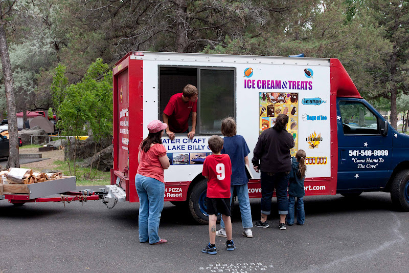
The ice cream man!!

Campin' is...... a visit from the ice cream man??   OK, this is something you don't see everyday.  I was surprised to spot an ice cream truck making rounds through the campground.  Not only did it sell ice cream, they also stocked bags of ice and firewood (see the trailer behind the truck?)  As you can imagine, it was a huge hit.  Someone had a good business idea.


It's not camping without s'mores

On to more traditional pastimes - Campin' is............ S'MORES!  You cannot have a campout with these tasty treats.  It's just not allowed.


JJ shows off his masterpiece

Who doesn't love the taste of a toasted marshmallow sandwiched in between a couple of chocolate squares and graham crackers?  My favorite - I spread some peanut butter on the graham crackers.  Yum!  Another tip - I've discovered marshmallows now come in different flavors.  I bought a bag of caramel flavored ones for this campout and they made our s'mores taste like Milky Way bars.  You gotta try it.


Roasting marshmallows is half the fun

 And of course you can't get through the marshmallow roasting process without at least one person burning their marshmallow. Or watching kids (and dads) throw stuff in the fire to watch it burn. You learn quickly who the pyromaniacs are!


The guys are cooking brats

Campin' is......... cooking your meals over an open fire.  Roger and my brother Dale decided to cook bratwursts for lunch.


Roger's brat is done

The brats weren't pre-cooked, so it took a long time and a lot of patience to make sure they were done all the way though.


The cooking crowd grows

Patience is a hard thing for a couple of hungry young boys.


Dale dropped his brat in the fire!


My poor brother dropped his brat in the fire - and it was almost done!  No matter, he washed it off and ate it anyway.   When you've worked that long and hard to cook something you're not going to throw it away!


Roger and Bear take a boat ride


Campin' is............ a boat ride on the lake.  Roger, Bear and I took our boat for a spin around Lake Billy Chinook.


Hidden waterfall

Lake Billy Chinook is made up of three large rivers dammed at their confluence.  It's fun to travel between the three different arms of the lake.  The steep canyons and coves hold many secrets.  There's even a hidden waterfall in one of the coves.  This tall cascade was roaring down the steep canyon wall.  To give you a sense of scale, that's a boat and floating restroom to the left of the waterfall in this picture.


Waterfall close-up

The rock formations on the waterfall's wall are very interesting.  Lots of geologic history right there in the open.


Water level cliff views

I love the scenery at Lake Billy Chinook.  It's great to glimpse the lake from high above on the Tam-a-lau Trail, but the lake level view is even better.  The enormous towering cliffs are amazing!


Cap'n Roger at the helm!

For Roger, campin' is........... Fishing!  He loves fishing Lake Billy Chinook.  He was a lucky fisherman this weekend, catching a few nice sized brown trout and later lots of bass.


Max and JJ get ready for the parade

Campin' is .......... the evening campfire program.  We always get the campsite next to the amphitheatre, so we have the first scoop on the action.


Getting ready to march

Sunday night's campfire program was different from any I've ever seen.  The camp hosts and rangers decided to hold a Memorial Day parade.  They provided the kids decorations for their bikes, scooters, or their bodies.  I wasn't sure if they'd get many participants, but a half hour before the designated start time, a large crowd of kids (and some parents, including a group of dads, beers in hand) had already gathered at the amphitheatre.


The start of the parade

Everyone decked themselves out in merry colors.  Flags waved.  Kids blew bubbles, hula-hooped, skipped and rode bikes.  The campground mascot, someone in a beaver suit, showed up (I happened to be wearing my OSU sweatshirt and couldn't resist yelling "go Beavs!")  The campground hosts all decorated their green utility vehicles.  It was a grand sight.


Marching through the campground

And it was the best campground parade I've ever seen.  The kids all had a blast.  It was good entertainment for us grownups too.  We kept busy clapping and cheering the kids as they passed by.

So that's my Memorial Day weekend in photos and short stories.  I do many types of camping, from visiting deluxe car campgrounds (as this one was) to primitive backpacking trips.  But I have to say the best part about every trip is the time spent with friends and family.

So most of all - Campin' is ............. spending quality time in the outdoors with the people that mean the most to you.


Thursday, May 31, 2012

The Tam-a-lau Trail

Last weekend, I left behind the lush green forests of the Columbia River Gorge for the barren high desert of Central Oregon.  I rendezvoused with my brother Dale and his family for our annual Memorial Day camping trip at the Cove Palisades State Park.


Size matters!  Click on any photo to enjoy a larger view.

The trail beckons...

Roger loves the Cove Palisades for its fabulous boating and fishing.   As you well know, I enjoy hiking, and - lucky for me - this park has the most wonderful path - the Tam-a-lau Trail.


Lake Billy Chinook and the Island


The Tam-a-lau trail takes its visitors up the side of a canyon, past unusual geologic formations, to the top of a large flat mesa (nicknamed "the Peninsula"). From this vantage high atop the canyon walls, views of Cascade peaks, from Mt. Hood to the Three Sisters line the horizon. Hikers are also rewarded with a perspective of Lake Billy Chinook from on high, which in itself makes for some jaw-dropping scenery. A 3.6-mile loop on top of the mesa, provides views of this lake from many different angles.  Over the years, my family has visited this park numerous times, and I've made many treks up the Tam-a-lau's dusty trail.


Steep cliffs on the Deschutes arm of the lake

I began this year's hike the sunny morning after our arrival to the park.  On a photography mission, I was hoping to catch some early light over the lake.  The trailhead, a short walk from our campsite, began in a scruffy juniper forest.  The path immediately launched itself uphill, switchbacking along the canyon wall.


Bear silhouetted against the sky

I chugged and puffed, ascending through the sparse juniper and sagebrush forest. Some of the years I've visited, the flowers bloom thick here. However, not this time - floral numbers were way down. The few blooms that remained looked way past their prime. Some scraggly balsamroot and lupine lingered down low, but they were nothing to write home about (or photograph).


The lake in all its glory

The big draw to the Cove Palisades is Lake Billy Chinook, an enormous three-armed body of water created by damming the Metolius, Crooked, and Deschutes Rivers. Over the years, erosion from these swift rivers has cut through soft sedimentary rock deposits, creating beautiful layered canyons. These steep cliffs that now tower above the lake shores form the centerpiece of the park's breathtaking scenery.


Bright little balsamroot


It didn't take much climbing before the shining blue waters of Lake Billy Chinook's Deschutes arm appeared.  The sparse trees and lack of undergrowth made for many lake view opportunities on the way up.


The Three Sisters rise up from the desert

Although it was a steep climb, the numerous viewpoints gave me an excuse to stop and take photos (and maybe catch a breather or two!)


The desert bushes were in bloom

The Tam-a-lau takes visitors through some interesting geologic sights, including an area of huge, truck-sized boulders, just sitting alongside the trail.  How these gigantic rocks got there is a mystery. They look very much out of place.  The trail also passes by a steep cliff, where some small caves have been eroded into the hillside.


Cool clouds over the lake

The Cove Palisades has a fascinating geologic history.  The layered canyons were created by ancient lava flows.  These lava flows formed the Cascade mountains and also caused land to sink in this area.  Rivers sought the lower elevations, and deposited layers of sediment.  These sediment bands were interrupted by deposits of ash and lava from occasional volcanic activities.  A final large volcanic eruption created a thick basalt cap, the canyon's rimrock.


Interesting volcanic rocks

After a mile of distance and 600 feet of elevation gain, I reached the Peninsula's rim.  Views from the mesa's top were glorious indeed.  Mt. Jefferson loomed gleaming white across the canyon.  The Three Sisters and Black Butte appeared in the western horizon.  Even a fuzzy Mt. Hood could be spotted faintly to the north.  Lake Billy Chinook spread out below, lined by its amazing cliff walls.


Lake panorama from on top

I hiked along the canyon rim, stopping frequently to snap image after image of the lake.  Two varieties of small yellow flowers were blooming, and these, along with the brilliant lime-green sagebrush bushes, made a nice contrast to the blue lake and reddish brown canyons below.


These flowers brightened up the trail

 
I hiked about a half mile or so down this trail when I began to get hungry.  In my haste to get up here early, I neglected to eat much for breakfast and was now paying for it.  Usually I'll at least hike the mile to the tip of the Peninsula (for its super-incredible views) and come back.  But my tummy wielded its power, and managed to persuade me to cut my hike short.


The boats look like small dots

No matter, the day was getting warm, and my memory card was beginning to fill.  I told myself I'd come back up here in the evening to catch the sunset (which sadly didn't happen - too many distractions at camp).  I enjoyed a quick trip back down the trail, seeing the lake from another interesting perspective as I descended.


Heading back down


Now with my annual Tam-a-lau visit complete, there's nothing more to do than to enjoy the photographs.  And I hope you have.  It's easy to see why this picturesque setting makes the Cove Palisades the most popular state park in Oregon.

But I'm not done yet - I've got more photos and stories up my sleeve!  Stay tuned for Part two of my Central Oregon Memorial Day camping adventure.