Wednesday, August 31, 2016

Tipsoo Lake and Sunrise Again

After spending all day hiking to Summerland in Mt. Rainier National Park, I was pooped.  All I really wanted to do was relax at my campsite with a good dinner and a beer (or three). 

But.....the final item on this weekend's agenda was a sunset visit to Tipsoo Lake.

Tipsoo Lake

I'd seen fabulous photos of this pristine mountain lake taken during peak wildflower bloom.  Mt. Rainier rose above, casting perfect reflections on it's calm waters, while a riot of colorful flowers lined the shore. 

Backlit Mt. Rainier

Tired or not, I couldn't pass up a chance to capture sunset at this special place.  So after refueling with a quick dinner, I packed up my camera gear and drove the short distance to Chinook Pass.


Blue water near sunset

Having never visited Tipsoo Lake, I had no idea of light conditions at sunset.  Turns out it was highly disappointing.  Mt Rainier, due west of the lake, was horribly backlit, providing no chance of a decent capture.


More paintbrush

But I was here, so despite my weary legs and sore feet, I hiked the additional mile around the entire lake.  The trip wasn't entirely a bust.  I did capture a few nice photos of magenta paintbrush.


A few straggling avalanche lilies

And also discovered a small patch of straggler avalanche lilies.


A beautiful lake

The setting sun illuminated Tipsoo Lake's waters a lovely shade of deep blue.


Gnats at sunset

And  huge clouds of gnats swarming above the trees made for a few interesting photo ops.

But I could tell sunset wasn't gonna be great, so instead of sitting around for the next hour, I opted to head back to camp early.  I was extremely tired and ready to take up the neighboring campsite's invitation to join them for a beer.


Rainier view from Sunrise road

The following morning, my last day in the park, I decided to revisit Tipsoo Lake on my way out.  But first the road up to Sunrise Lodge called my name.  Since my Friday hike was cloudy and foggy I'd missed seeing the fabulous mountain views.  After two days of hiking, I wasn't ready for another long climb from the campground.  Today I'd take the lazy way up.


Sunrise Point

The road up to Sunrise, is long and winding.  Built in the 1930s by the Civilian Conservation Corp, it was designed to be driven slowly, so visitors could take in the tremendous views.


Mt Rainier fills the sky

And tremendous they were!  From near the huge parking lot that marked road's end, Mt. Rainer dominated the skyline.  Although I decided not to spend any time walking around the visitor center this time, I did get some fantastic views and photos of Washington State's iconic mountain.


Tipsoo Lake in the morning

Then I headed downhill (passing a half dozen very adventurous bike riders screaming down this narrow road) and climbed back up Chinook Pass to see Tipsoo Lake again.


Wildflower meadow

Morning light was way better for photography.  Rising up behind Tipsoo Lake, Mt Rainier was illuminated perfectly.


Rainier reflections

The prior evening, I'd noticed a few people crossing the road and disappearing into a wooded trail.  Where were they going?  Time to find out!


Upper Tipsoo Lake

I discovered another lovely alpine pond.  Not only was it lined with a few brilliant wildflowers, Mt Rainier was situated so that it cast a perfect reflection in it's still waters.


More magenta paintbrush

So this was where the photographers got their money shots!  After capturing several images of this wonderful reflection, I began to trek around the lake's perimeter, hoping for another good angle.


Path above the lake

But my legs and feet, worn out from two long hikes in as many days, protested loudly.  I ended up only climbing part way before calling uncle.  But at least I'd found the coveted photo spot.


Mountain panorama

A successful weekend of exploration!  After a long absence, I'd finally returned to Mt. Rainier National Park.  Although the peak wildflower bloom was yet to come, I'd gathered data on where and when to photograph some of it's natural wonders.  And after discovering how short a drive it is to get here, I guarantee I'll no longer be a stranger. 

Hmmm......fall color trip?


Thursday, August 25, 2016

Summerland

(Part two of my late July trip to Mt. Rainier National Park)

After hiking all around Mt. Rainer's Sunrise area the first day, I slept like a log.  But the early morning light (and a full bladder) roused me from my slumber.  Rise and shine!  Today was a big day - I planned to explore a lovely place called Summerland.


Monkeyflowers

Summerland, a high alpine meadow practically under the shadow of Mt. Rainier and Little Tahoma mountains, is one of the most popular hikes in the park.  In late summer, when the wildflowers begin to bloom, the place is reputed to get overrun with hikers and backpackers.


Ranger crossing the White River

From the official trailhead on the park road, the Wonderland Trail to Summerland is an 8.5 mile round-trip journey.  But not wanting to drive from my camping spot, I opted to travel the extra distance from White River Campground.  Yes, I was fully aware this would add over five extra miles to my total, but figured what the heck, I had all day.


Boiling, boisterous White River

My first bit of excitement came right away with the crossing of treacherous White River, right below the campground.  This fast-moving glacial stream looked mighty intimidating and at first I was unsure of how I'd cross.  Luckily, the trail led to a series of log bridges, which made traveling over the river an easy task.


Tiny cairn

I will admit that the third log crossing over the most turbulent channel got my heart racing just a teeny bit!


Scary river crossing

On the river's far side the Wonderland Trail continued southward, through a gorgeous, mossy forest.


Lovely old growth forest

I'd begun my hike fairly early in the morning, and immensely enjoyed the morning clouds, as well as the cool temperatures.  Cloudy skies made for some great photographic conditions to capture this lovely forest.


Wonderful trees and shade

The extra 2.6 miles to the junction with Summerland's parking area seemed to take a long time.  After a mile of level hiking, the trail dipped steeply downhill, which I soberly realized I'd have to climb back up at the tail end of today's journey.


 A rare viewpoint

With the exception of a lone trail runner, I was by myself the entire first leg.  But upon reaching the trailhead proper, I joined in with the mass of humanity.  Large numbers of hikers were already on the trail, everyone heading for Summerland.


Glaciers and waterfalls

Although the path climbed steadily, it was mostly forested.  The woods parted in a few places, giving visitors great views of the nearby steep cliffs, with several hanging glaciers and waterfalls.  A couple clearings offered views into Fryingpan Creek's deep canyon.


First Mt Rainier sighting

The morning clouds burned off quickly.  Temps were predicted to be toasty, and by mid-morning, I was already sweating buckets.  When the trail crossed a sunny area, the air felt much hotter.  But I kept steadily climbing, thankful for the thick forest's shade.


Path through lush greenery

But after three miles of climbing, the path crossed Fryingpan Creek's rocky bed and entered a bushy, green meadow. 


Flowers and mountains

It was here I got my first glimpse of Mt. Rainer, her glaciers gleaming a blinding white in the midday sun.
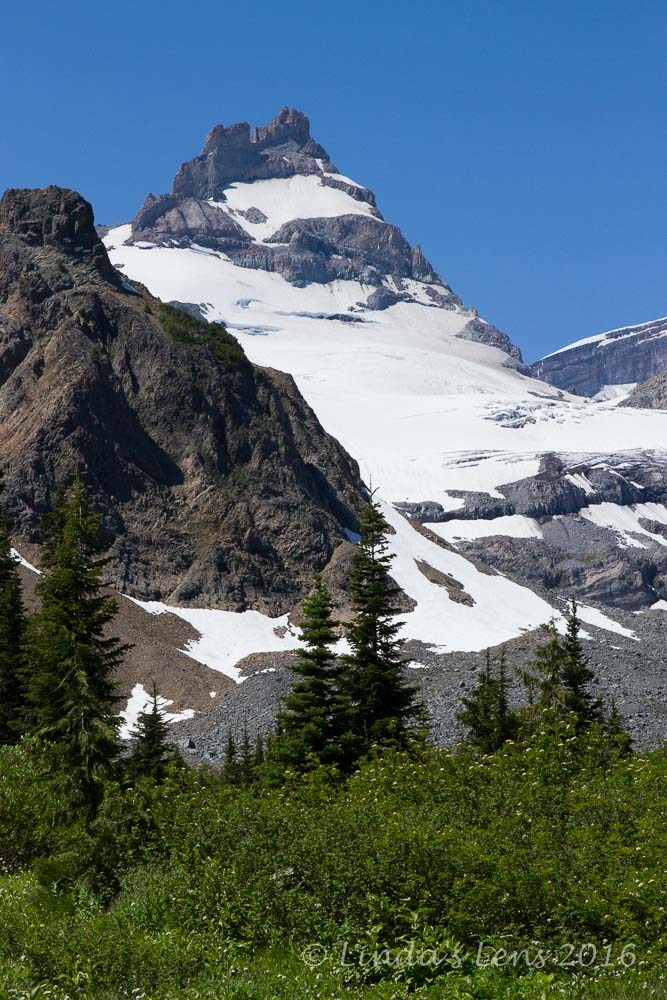

Little Tahoma

Although I missed the forest's cool shade, I did enjoy the fabulous mountain views.  Not only Rainier, but the pointy top of Little Tahoma rose prominently over the horizon.


Little Tahoma and Mt Rainier

Another great bonus - this meadow was full of wildflowers!  My pace slowed as the camera came out to capture all this beauty.


Summerland meadows

By now I'd covered nearly six miles.  I was hot, sweaty, hungry, and my feet hurt.  But Summerland couldn't be too far.  I kept walking, thinking it had be just around the bend.


Fantastic Rainier view

Except that it wasn't.  The meadow kept on going.  From reading the hike description, I knew the last half mile was a steep climb up a bunch of sharp switchbacks.  My hopes were dashed when I asked a group hiking the opposite direction if I was close, only to be told "about one more mile."


More lush alpine meadows

After more hot walking, the trail finally began to rise.  And up it climbed!  Through a steep, rocky pitch past a lovely patch of avalanche lilies.  I puffed and panted, sweating as I struggled up the hilly inclines.  It was near one o'clock, and having not eaten much since early morning, my energy level started to flag.  It was the beginnings of a massive bonk.


Glacial stream and flowers

The last half mile was an extremely slow climb, but suddenly the ground leveled off, and Mt Rainier filled the skyline.  Up ahead, a sign directed backpackers to the designated camping area.  I saw a stone shelter cabin where several hikers were sprawled out taking a lunch break.  I had arrived!


Truly an exceptional place!

Gratefully, I claimed a spot on a nearby log.  Sitting down had never felt so good!  I took off my boots and socks to let my sweaty, achy feet air out.  Then I dug into my lunch.  It wasn't much - a couple of string cheeses, some salami, an apple and a Cliff bar, but it tasted delicious.


Back on the trail

After eating, I made myself sit and rest for a good 20 minutes.  The food and mandatory downtime really helped recharge my inner batteries.  After a quick visit to the outhouse (yes, there was an actual toilet here!  But you had to bring your own tp)  I was ready to hike again.


Purple asters

Below the Summerland shelter cabin, I noticed lots of people heading towards a lush meadow.  Curious, I followed the trail to a small alpine valley with a creek gurgling through the middle.  Mountains rose from three sides, and colorful flowers bloomed at water's edge.  Oh it was jaw-dropping!


Heading back through the flower fields

A park ranger passing through told me the summer wildflower bloom was just getting started.  Boy, if this was just the beginning, I wished I could see this area at peak bloom.  I made a mental note to return later next year, possibly in August.


Sturdy log bridge

After taking a good half hour to photograph, explore and admire this gorgeous alpine meadow, I knew it was time to head back.  My gps said I'd traveled 7.5 miles so far.  That meant I had to cover this same distance on my return.  It was gonna be a long, tiring slog back to the campground.....


Final grand view before heading into the forest

But at least most of it was downhill!  The steep half mile climb before Summerland was now an easy cruise.  I passed dozens of hikers, all toiling up this slope in the afternoon heat (I was extremely thankful to have this part behind me).  Reaching the cool forest, I put my legs into high gear and concentrated on covering ground.


Dainty flowers

The time passed quickly.  I kept promising myself gummi bears for every mile covered.  Soon, I was back to the junction with the parking area.  Okay - only 2.6 miles left!  Except....I  had that steep slope to climb.


A family way too close to the strong current

The trek through the last couple miles of forest seemed to take an eternity (I swore someone came out and stretched the trail!)  My feet were hurting, I was hot and sweaty, and just wanted to be done.

But finally, I saw an opening through the trees, and there was the White River!  Boy was I glad to see that swirling glacial stream, even if it meant I'd have to cross it again.


Color spot

The hot day's snowmelt had swollen the White River, and it was a muddy, churning powerhouse.  The current was moving so fast, it scared me.  Crossing back over the main channel was even more nerve-wracking than the morning.  And, as I prepared to cross, I noticed a family with a small child standing at the river's very edge.  The child couldn't have been more than two years old, but the parents weren't doing anything to keep him away from the strong current.  I was almost ready to say something when the parents finally pulled their child back.  Be careful people!  This is how tragic accidents happen!


Majestic Rainier view from the White River

As I crossed the White River's rocky plain, not only did I notice many patches of brilliant pink monkeyflowers, but looking upriver, noticed Mt.Rainer peeking behind a patch of clouds.  A great final view to end my hike.

My gps clocked a round-trip distance of 15 miles.  No wonder my feet ached!  Luckily, a tiny creek ran across my campsite and upon my return, the first thing I did was fling off those boots and soak my tired feet in it's icy waters.

But the sweltering climb, long distance, and achy feet were totally worth access to this magnificent alpine meadow.


Sharing with:  Through My Lens

Saturday, August 20, 2016

Mt. Rainier National Park

I have a confession to make...

While cavorting all over visiting National Parks, I'd neglected the one closest to home.  Although Mt. Rainier National Park is a mere 3 1/2 hour drive away, I've been there a grand total of once, and that was way back in the 90s.

Time to get reacquainted!


Stevens Canyon Entrance

In late July, I planned a return trip to coincide with one of my three-day weekends.  Early that Friday morning, after dropping my hubby off at the Portland airport for a business trip, I continued northward into Washington State.


Wonderland Trail to Sunrise

I didn't make campground reservations (I learned the White River Campground was first-come first serve), and was a little bit worried about securing a site for the weekend.  Arriving around 11 am, I was surprised to find it nearly full.  After driving around the campground for 30 minutes, I got lucky and spotted a just-vacated site.  Quickly, I parked my car and hurried to pay.  I think I got the very last one!


Waterfall on the Wonderland Trail

The White River campground is situated in the NE corner of the park.  To reach the nearby Sunrise Visitor Center it's a short drive or 2.5 mile hike.  Can you guess which option I chose?


Mt Rainier is hidden in the clouds

Yep - after setting up camp, I donned backpack and headed up the Wonderland Trail, destination Sunrise Lodge and Visitor Center.  The Wonderland Trail is a 95.2 mile long trail that circles Mt. Rainier's entire base and I was excited to be hiking a small portion of this famous path.


Junction with the Sunrise Trail

It was a tough 2000 foot climb through mostly viewless woods.  Not much for wildflowers blooming either, but the path did cross underneath a cool waterfall about halfway.


Beautiful purple flowers


Reaching the first junction, I took the half mile trail heading to Sunrise.  After having the uphill climb mostly to myself, it was a shock to encounter so many people!  I hiked with the crowds all the way to the visitor center.


Sunrise Visitor Center

Sunrise didn't impress me.  It's huge parking lot was full of vehicles.  The weather-worn lodge looked like it had seen better days.  The visitor center looked like a log stockade from the Davy Crockett days.  And people were everywhere.


Sunrise Lodge

I made a quick trip inside the visitor center to check it out, buy a pin for my collection, and inquire about the best wildflower hikes.  Then I headed to a nearby picnic area for a quick snack and to figure out where to go next.


Hiking above Sunrise

A plethora of hiking trails departed from Sunrise.  Some climbed high up nearby ridges, others followed level alpine meadows. The morning's rainy weather had given way to low-lying clouds and cool temps.  Although it was no longer raining, foggy skies hid most of the majestic mountain views. 


Lots of foggy clouds up high

Where did I want to hike?  Should I climb higher?  Or stay low and look for wildflowers?  Seeing large groups of people heading up the trail to Frozen Lake, I made a snap decision to follow the crowd.


Purple flowers

At first I thought I'd made a mistake.  The trail climbed higher into the fog.  Views became obliterated by the low-hanging clouds.  The temperatures dropped, and I put on all the layers I had with me (which wasn't much).


Teaser peeks of the mountains

But after crossing a high saddle, the skies began to clear slightly.  I began to see the green forest below, and adjacent mountains began to show themselves.


Penstemon

The wildflowers up here were sparse, but what they lacked in quantity, they made up for in quality.


Trail across the talus slope
The trail crossed a long talus slope.  About halfway across this slope was a patch of bright pink heather.  Really brightened up all that dull gray.


Big patch of heather!

Then I began climbing the final steep pitch to frozen lake.  Along the way, I passed some lovely alpine meadows decked out with vivid orange paintbrush.


Orange paintbrush brightens up the landscape

Approaching Frozen Lake, the fog sunk down to trail level.  Temperatures hovered near freezing, and a few icy raindrops pelted the hikers.


Path to Frozen Lake

Oh, it was miserable!  The wind blew and I swear the raindrops began morphing into sleet pellets.


Frozen Lake in a foggy sleet storm

To top it off, the lake was shrouded in clouds, making it extremely hard to photograph.  But I did my best, trying to capture it's amazing ice formations along the far shores.


Blue glacial ice
Where to go next?  Should I retrace my steps back to Sunrise?  Or take the Wonderland Trail down through some more alpine meadows?  One thing I knew for sure, I was freezing and had to get out of this place.


Back down the Wonderland Trail

In the end, after a few wrong turns, I located the Wonderland Trail and decided to do more exploring.


Very foggy here

The Wonderland Trail dropped steeply down off Frozen Lake's high ridge.  The fog began to lift and temperatures increased dramatically.


Snowfield crossing

I did however, have to cross a couple of snowfields.  But they were a snap, thanks to my skiing experience, and my trekking poles.


Magenta paintbrush and mountains

Below the snowfields, the alpine meadows began opening up, and so did the wildflowers!  Lovely magenta-colored paintbrush dotted the landscape.


Only wildlife sighting

I even caught a little chipmunk peeking over a rock - my only wildlife sighting of the day.


More gorgeous paintbrush

The alpine meadows were fantastic!  Flowers and partial mountain views - Now I was glad I'd decided to come this way.


Shadow Lake

I passed by lovely little Shadow Lake, it's water a mixture of brown and forest greens.  A  nearby backpacking campground was plumb full of weekend campers.


Wildflowers at Shadow Lake outlet

I loved all the wildflowers at the lake's outlet too.


Pink heather meadow

Near the Sunrise Trail junction, I passed by a meadow full of pink heather.  Outstanding!  I also crossed a few gorgeous bubbling mountain streams, fed by glacial snowmelt.


One of many mountain streams

Finally locating my path back to the campground, I began retracing my steps downhill.  But just before the trail disappeared back into the woods, the clouds parted and I got a great view of Mt. Rainier's summit in all her glory.


Mt Rainier finally came out!

Arriving back at camp, the neighboring site invited me over for stew and beer.  A group of five friends from Tacoma, they were so welcoming, I spent a couple of pleasant hours around their campfire, before finally crawling into my sleeping bag.  Tomorrow was another big day - I planned a hike into the fabulous wildflower meadows of Summerland.

Stay tuned - I'll cover that adventure in my next post!


Sharing with:  Scenic Weekends and Through My Lens