Wednesday, August 27, 2014

Paradise Park

Paradise Park....The very name evokes images of incredible alpine beauty.  How could I resist not planning a visit?


The PCT near Timberline Lodge

From late July into August, the meadows below Mt. Hood's south side erupt into colorful carpets of wildflowers.  Mt. Hood towers above, anchoring the skyline.  Paradise Park is indeed an amazing place, totally deserving of its name.

The hike to this special area is long, over 12 miles if one does the entire loop, and arduous - the final two miles are uphill.  But the incredible scenery one encounters is well worth a little extra effort.


Blooming purple lupine frame Timberline Lodge

The trail to paradise starts at Timberline Lodge.  My normal backcountry skiing haunt, it was fun to see it in early August, checking out what the ski trails looked like without several feet of snow.  The Pacific Crest Trail (PCT) passes right by the lodge, and I couldn't resist a quick photo op by the sign.


Busy chipmunk

In the flowery alpine terrain above Timberline Lodge, a few busy chipmunks were scampering around, frantically gathering food for winter.  One little guy was so cute, I just had to stop and get some photos.


Tons of purple daisy-like flowers

The first mile was a delight.  Tons of purple lupine, and lavender daisy-like flowers lined the trail.  Although the sky was cloudy, Mt. Hood peeped out occasionally, giving me glimpses of her rocky slopes. 


Chairlifts waiting for snow

I walked under ski lifts, silent except for one.  The Magic Mile lift was still turning, transporting skiers to glacial snowfields high on the mountain.


This way to Paradise Park!

Yeah.....with so many wonderful photo subjects, let's just say I didn't cover the first mile in record time.  I leapfrogged a bit with an older couple, who turned around after a short distance.  Upon seeing me on their return trip, the man remarked "You're not going to reach your destination if you keep stopping to take pictures all the time."


Fireweed blooming beside a spring

But taking photographs is what I do, so onward I advanced (even if it was rather slowly).  I passed a small spring surrounded by lovely rose-colored fireweed flowers.


Zigzag Canyon

I crossed a small glacial melt stream in Little Zigzag Canyon.  Upon climbing up the opposite bank I ran into my first PCT through hiker, a young man traveling southbound.  The man told me he'd began his journey exactly one month ago at the Canadian border.  He was looking forward to reaching Timberline Lodge and partaking of their famous hiker buffet.


Creek crossing in the bottom of Zigzag Canyon

Bidding the man goodbye, I continued on across rocky slopes decorated by an occasional lupine bloom.  Shortly, I reached the eastern bank of Zigzag Canyon.  An enormous, deep depression formed by melting glaciers, it was an impressive sight.  Standing on the exposed overlook peering down into the canyon's wide valley made me feel mighty small.


A few paintbrush were blooming

Thus began the long trip down, down, down 600 feet to the canyon bottom.  It took some time, but finally I found myself at the rushing waters of Zigzag River.  Formed by melting ice of the Zigzag Glacier, by midday it was already churning mightily.


Lots of lovely meadows

Now I'm not a huge fan of river crossings.  They always strike a tiny bit of fear in me.  Balancing on rocks over fast water can be rather scary.  As with any glacial stream, the Zigzag River is sometimes tricky to traverse.  I walked up the bank for a short distance, looking for rock cairns that signaled a crossing point.  Luckily, I found a narrow spot in the river that I was fairly sure could be jumped across.  As with most river crossings, they always look much worse than they really are, and happily I hopped across the gap with no problem.


The famous flower-filled meadow

What goes down must come up, so after my successful conquest of the Zigzag River, came a trudge up the steep, gravelly opposite bank.  But after a long, sweaty climb, I reached the first junction of the Paradise Loop Trail.  Not much further to those wonderful wildflower meadows!


This is truly paradise!

I wound along the trail, heading uphill.  Occasional patches of lupine and purple daisy flowers lined my path.  But I was disappointed to see most of the daises were wilted.  It's been a very hot summer here in Oregon, and the flowers appeared to be victims of the unseasonably high temps.


Flower-lined trail

Finally, I reached the wonderful meadow.  Located at a junction of two trails, this grassy field erupts in a riot of color by late summer.  But this year, although speckled with lupine, small yellow, and fluffy white flowers, the show was not near as spectacular as in past trips.  (Check out this post from a prior year's visit).


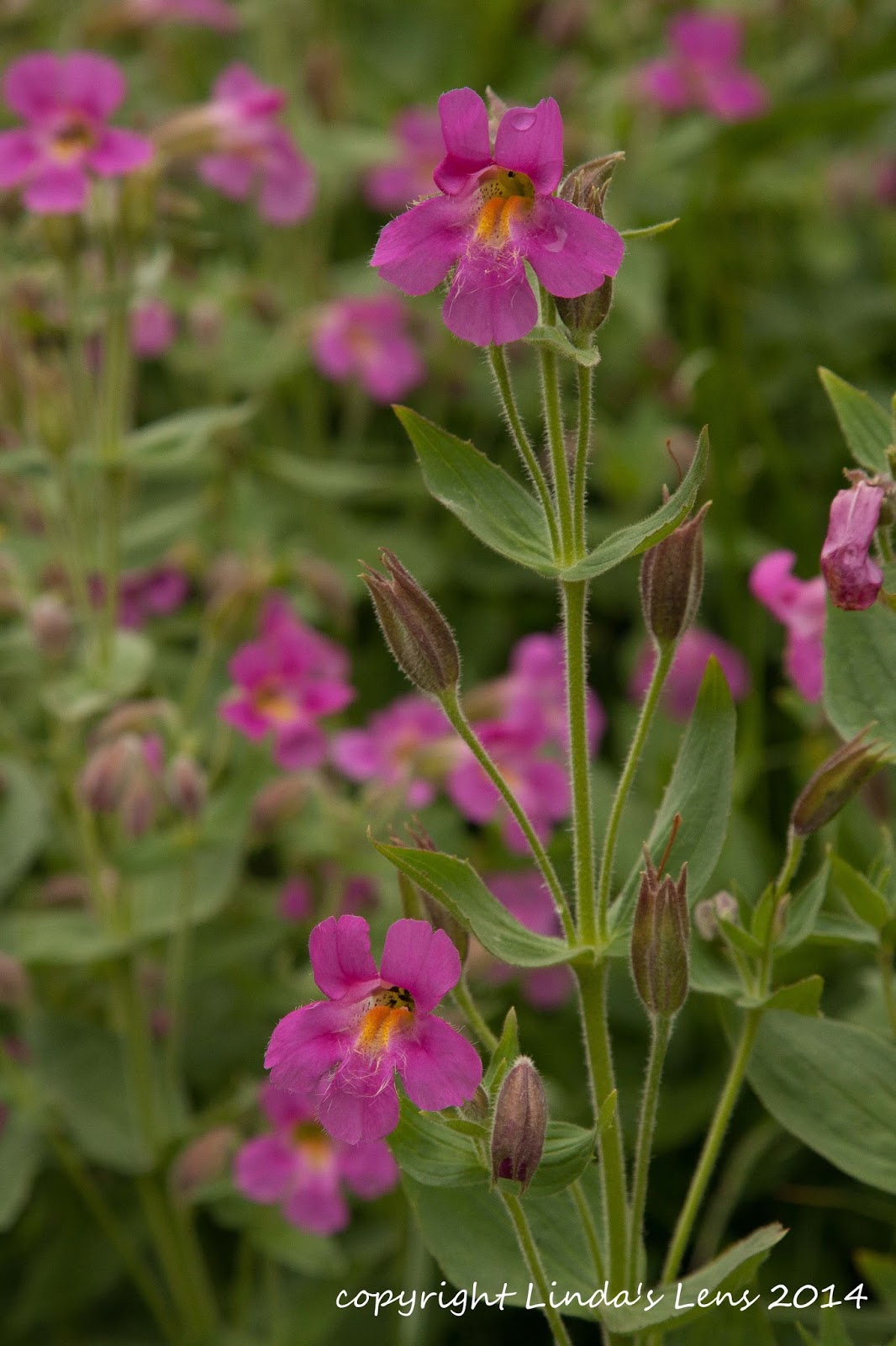
These monkeyflowers are pretty in pink

But the meadow did make an excellent lunch spot, and being it was well past noon, I eagerly dug into my food bag.  The sun came out for a short period, but I was too busy eating to even think about grabbing my camera and taking advantage of the nice light.  Once I was done, the mountain had clouded over again, and I'd lost my golden opportunity.


Lovely little creeklet

Remembering from past visits that more colorful meadows could be found further down the trail, I packed up my things and continued on.  Although the clouds were now obscuring Mt. Hood, I was able to find lots more pretty scenery closer in.


Colorful bouquet

I crossed a small creek lined with many varieties of bright blooms.  There were pink monkeyflowers, vibrant orange paintbrush, and frilly yellow and white blossoms.  Probably the best flowers of today's trek, I made sure many images were duly recorded on my memory card.


Lupine rules this meadow

By now it was mid-afternoon, and I could see the skies clouding up even more.  Afraid that a storm was brewing, and not wanting to get caught in a downpour, I decided to head back.


Lots of purple here!

Having photographed everything extensively on my outbound trip, I put the pedal to the metal on my return.  The climb out of Zigzag Canyon was long, sweaty and arduous, but I survived.

One of the highlights was meeting a northbound PCT through hiker named "Lighthouse" and catching a bit of his conversation with another hiker.  It was thrilling for me to meet two actual PCT through hikers in one day.


Heading back to Timberline Lodge

Approaching Timberline Ski Area's boundary, I began to meet more and more people.  Most of them were guests of the lodge, out on short evening hikes.  (A shout out to Jennifer, a very nice lady from Texas I met on the way back, who was planning to hike a portion of the Timberline Trail). 


Mt. Hood finally reveals herself

Reaching Timberline's parking lot and the car, I was surprised to see my gps had logged a total of 11.5 miles.  No wonder my feet hurt!  Taking off my boots, I looked up to see Mt. Hood finally emerging from her cloudy curtain.  Just in time to wish me goodbye and goodnight.

As with all my hikes, although the flowers weren't up their usual stunning displays, it was still wonderful to spend a day rambling around my favorite mountain.


Sharing with:  Our World Tuesday.

Wednesday, August 20, 2014

Cooper Spur

"The Forest Service has finally opened Cloud Cap Road!  Let's go hike up Cooper Spur."


Fab Mt. Hood view from Cloud Cap Rd

I recently discovered my skiing friend Mary Ellen had Fridays off.  Time to team up for a weekday hike!  Mary Ellen discovered that the road to the Cooper Spur Trailhead was opening the very day we'd chosen to go hiking.  Of course, we had to check it out.


The lupine were out in force!

Cooper Spur is a huge glacial moraine on the northeast side of Mt. Hood.  Directly southeast of the Elliott Glacier, it stretches from above the historic Cloud Cap Inn to it's highest point, the "Tie In Rock" at 8500' elevation.


The lupine were thick below treeline

In 2008, an enormous forest fire (the Gnarl Ridge Fire), swept through this area, charring the woods along Cloud Cap Road, and threatening the historic Tilly Jane Guard Station and Cloud Cap Inn.  When it was all over, these buildings were still standing, but the road was lined with hazardous dead, burned-out trees. 


Timberline Trail junction

Between 2009 and 2013, the road was open intermittently during summer months.  But in July of 2013, the Forest Service closed the road to facilitate logging activities.  When all the old burned-out hazardous trees had been removed, the road was reopened - which, lucky for us, happened to coincide with our chosen hiking day.


Still a few good lupine patches

A bright, sunny August morning found Mary Ellen and I navigating the windy, 9-mile Cloud Cap Road.  The road was not much more than a one-lane dirt path through a ghostly burned-out forest.  But the fire had created some nice unobstructed views of Mt. Hood and flowers bloomed prolifically in the rich ash-enhanced soil.  While Mary Ellen drove, I admired the lovely scenery.


Huge purple patch

Our hike began at the primitive trailhead campground.  The Forest Service wasn't too prepared for hikers, as the pit toilet was missing both it's door and TP.  But no matter, it was good to be able to access this area once again.  I filled out our wilderness permit, and we hit the trail.


Above treeline, only boulders

After following the Timberline Trail through a fir forest, and up a bouldery gully, I began to see large clumps of lovely purple lupine blooming amongst the trees.  It brightened up the forest, and I couldn't resist getting a photo (or ten!).


And a few of these yellow ground cover

After a mile of following the Timberline Trail, Mary Ellen and I reached a junction with the route up to Cooper Spur.  From this point on, trees and other vegetation dwindled down to nothing, and the climbing began in earnest.


Trudging up the wide switchbacks

We quickly ascended above treeline, passing by a field of huge boulders.  These monoliths, called "erratics" were left behind from a long-ago retreating glacier.  The trail here was really rocky, and I wasn't real thrilled about navigating through all these hard, sharp stones.


Elliott Glacier overlook

From the Timberline junction our trail would climb nearly 2000 feet in 2.7 miles.  To help lessen the strenuous nature of this uphill trek, our path consisted of many long switchbacks, contouring along the entire side of the ridge, and back across. 


Looking back down the Elliott drainage

Looking ahead to our goal, it almost looked quicker to climb straight up the rocky slope.  Seeing another hiker charging up the ridge, Mary Ellen and I decided to give it a try.  We lasted one switchback, and then decided to return to the trail.  Navigating the long switchbacks was a bit easier on the legs and lungs.


Climbing above the glaciers

At one point, the trail led us up to the very edge of the Elliott Glacier's deep canyon.  Peering down below, I could see a narrow ribbon of meltwater snaking down the center.  Looking upstream gave an incredible view of Mt. Hood's northeast face and the Elliott Glacier's fractured, icy surface.  To the north, distant white peaks of Mt Adams, Rainer, and St Helens appeared above the skyline.


Japanese rock

Our route wound through a moonscape of rock and sandy soil.  Mt. Hood anchored the sky above, beckoning us to continue onward.  Up ahead, we could see a spot where the ridge flattened out.  But first my friend and I had to traverse this steep, rocky slope.  When our trail suddenly dead-ended into a snowfield, Mary Ellen suggested we head straight up through the boulder field.


Helicopter circling Hood

That was the toughest part of our hike.  It's no fun winding through a large field of rocks.  The soil below wasn't always stable, and you really had to be careful where you placed a foot.  Every once and awhile a rock would wobble or slide.  Add to that the fact that we were traveling nearly straight up, and it made for a tiring climb.


Final slog up the moraine

But finally we reached the top of this steep, rocky slope and the trail thankfully leveled out.  A few stone windbreaks had been constructed here, likely from climbers or backpackers spending the night.  Nearby was a large boulder with a date and some Japanese characters etched on it.  During later research, all I could find about this rock was that it commemorated a 1910 Japanese climbing expedition to Mt. Hood's summit.  The visitors were from Hiroshima, so it is informally referred to as "Hiroshima Rock."


Tie-in rock is in sight!

By this time, it was well past noon, and Mary Ellen and I were famished.  Although there was still a little bit of climbing left to reach Tie-in Rock, we both agreed a lunch break was in order.  I found a nice, flat rock and we stretched out in the sun and began to fill our bellies.  The views from our perch were amazing - Mt. Hood's northeast face rose up before us, so close it appeared you could almost touch it.  Towards the east, the entire Hood River Valley spread out in a mosaic of browns and greens.  We could even spot smoke from the latest fire, burning near the town of Mosier.


Plaque on Tie-in rock

Our lunch break was not exactly peaceful.  We'd barely unpacked our sandwiches, when the mountain emitted a low rumble.  Mary Ellen spotted a large rockfall high on Mt. Hood.  It appeared to be sliding down the Newton drainage to the south of us.  From our perch on the Cooper Spur moraine, we were totally out of it's path, so it was very interesting and humbling to watch the power of rocks and soil sliding down the glacial ice.


High above the glaciers

The dust had barely settled from the rockslide, when I heard a low buzzing noise.  Mary Ellen spotted a helicopter circling the very top of Mt. Hood.  It kept flying low, very close to the mountain's face appearing as if it was searching for something.  Neither of us had heard of any lost climbers recently (mid-summer is not the time to be climbing Hood).  We both surmised that with the melting glaciers opening up crevasses, maybe the 'copter was looking for people lost in previous winters.  The aircraft circled the mountain for a good 45 minutes, and the buzzing noise got to be quite annoying.  We'd hiked up here to get some peace and quiet after all!


Glacier ice close-up

But finally the noisy helicopter left.  Mary Ellen and I finished our lunches, and hoisted our packs for the final leg of our hike.  We followed the knife-edge of Cooper Spur's steep moraine, through  loose, sandy soil to Tie-in Rock, our day's goal.


A very happy Mary Ellen

It was slow, tough going.  Our boots kept sliding backwards through the unstable soil.  And the final pitch up to our goal was extremely steep.  But finally, up ahead, I spied a large boulder with a small plaque attached to it's side.  This must be the famous Tie-in Rock!


Descending through a snowfield

Tie-in Rock gets it's name because beyond this point is where mountain climbers traditionally rope up when they're climbing Hood.  The mountain rises to near vertical from this point, riddled by glaciers and loose rocks.  Climbing ropes are a must if one wishes to continue.  I had no desire to go any further from here!


Nice views of distant mountains

Mary Ellen and I soaked in the fabulous views from our lofty perch.  The Elliott Glacier spread out below us.  I could see all the deep crevices in it's dirty white ice from a very close range.  It's not very often you can hike above a glacier!  Mt. Hood's summit rose high above, nearly blocking out the sky.  And there were more great views of valleys and hills to the east.  Although the page from my Sullivan hiking book put the elevation here at 8500 feet, Mary Ellen's altimeter read 8800 feet.  (I'm going with the higher number.)


Huge erratics

After admiring the panorama we'd worked so hard for, and taking copious photos, my friend and I headed back down the slippery scree.  As with all hikes, descending went way faster than our morning climb.  Before I knew it, we were back at the point where a snowfield blocked the trail.  Since the afternoon sun had softened the snow by now, Mary Ellen and I decided to march across.  I actually had fun - the icy stuff felt good on my hot feet, and I enjoyed kicking steps into the soft, slushy snow.


We spot the stone shelter

As with McNeil Point, Cooper Spur also boasts it's own stone shelter.  Built in the 1930's by the Civilian Conservation Corp, it offers climbers a primitive refuge from the elements.  On the way up, I'd been so intent on photographing lupine, that I walked right by without noticing it!


Cooper Spur Shelter

Mary Ellen and I were determined not to miss the shelter again.  All the way down, we kept our eyes peeled, and nearing the Timberline Trail junction, we finally spotted it's metal roof.  Situated in a very scenic location, one can see Mts. Adams and Rainer, plus the Hood River Valley, and surrounding hillsides.  A few cleared areas with stone windbreaks had been built for backpackers to pitch their tents.  Looked like a great place to spend a clear summer's night.


Happiness at 8800 feet

Reaching the parking lot, I thanked Mary Ellen for her great hiking suggestion.  It was a wonderful day to be high up on the mountain.  The weather was picture-perfect, the flowers at peak bloom (down low anyway) and it's not every day you can say you climbed above a glacier!


Total stats for the hike:  8 miles, 2800 feet elevation gain.

Sharing with:  52 Photos Project and Weekly Top Shot

Saturday, August 16, 2014

Groovin' in the Gorge

I love live music.  It's always fun to see and hear your favorite band in the flesh.  And during the summertime there's no better concert venue than the great outdoors.


Let the show begin!

Back in 2011, I won tickets to see Styx perform at the Maryhill Winery.  Located on the Washington side of the eastern gorge, the winery constructed an amphitheater on the banks of the Columbia River overlooking vineyards, steep bluffs, and wind turbines.  It was such a perfect place to view a concert, I'd been wanting to come back ever since.


Maryhill amphitheater

When Maryhill announced their 2014 concert schedule, I was thrilled to see Styx on the list.  Even better - they were paired up with Foreigner.  Two favorite bands from my high school days! (Yes, I realize I'm dating myself)  I bought tickets the minute they were available.


Golden hills of the eastern Gorge

Concert day was the first Saturday of August.  Blazingly hot in Portland, temps only rose higher as Roger and I headed east.  But once we we arrived at the winery, and settled in to a spot on the lawn, a thin cloud layer slipped over the sun.  Ahhh....not having the sun's hot glare beating down upon us helped so much.


The local vino

The venue allows concert-goers to bring in outside food and sealed, non-alcoholic drinks.  But if you wish to imbibe, one must purchase wine from the winery.  And it isn't cheap!


Of course we had to try some!

But this was a special event, so we decided to spring for a bottle.  Gotta sample the local vino!


Foreigner takes the stage

Waiting for the concert to start, we lazed around in the grass, sipping our wine, eating our sandwiches and cheese, and watching the crowd around us.  It was people-watching at it's finest.


This guy's t-shirt made us laugh

There were lots of gray-haired people in the crowd.  Roger and I laughed about all the "old farts" sitting around until we realized most of them were probably the same age as us!  But it was fun to see so many folks having a good time.  Everyone reliving their younger years - remembering the first time they'd seen these bands.  We even noticed a lady, well into her 70s, who stood along the sidelines dancing away.


Colorful crowd

Foreigner took the stage first.  Although we were told by the people sitting next to us that the original band members no longer tour, the new "Foreigner" sounded just like I remembered from high school days.  They put on a great show and had the crowd rockin'.


Time for Styx

Then after a brief intermission, Styx took the stage.  As with Foreigner, there's only one original member of Styx that still tours with the band, guitarist Tommy Shaw.  Sadly, the man who replaced their lead singer (the amazing Dennis DeYoung) was nowhere near as good.


No more flicking your Bic - now everyone turns on their cell phones

At one point in the show, the audience was encouraged to turn on their cell phone screens and hold them high.  A 21st century equivalent of "flicking your Bic" before the concert (anyone remember doing that??)


Confetti finale

Styx only played a little more than one hour, before ending their show in a rain of confetti.  The sparkling paper bits twinkling in the stage lights made for a great photo op (except that someone walked into my frame....)


End of the show

Although Styx was a bit disappointing, it was still fun to be outside enjoying music and wine in a beautiful setting.  I'm ready to do it again next year.  Wonder when Maryhill's 2015 concert schedule comes out?


Sharing with:  Our World Tuesday