Thursday, September 27, 2012

M Hill

Painting the local school's letter on a nearby hill is a popular tradition.  It seems to be prevalent across the American west (the exception being the west coast).  My hometown sports a large "M" prominently whitewashed on a high point in the middle of town.  This letter honors a local engineering college, The South Dakota School of Mines and Technology  The "M" stands for "The School of Mines" and the hill it resides upon is known locally as "M Hill."


Size matters!  Click on any photo to enjoy a larger version.

Can you spot the M?

SD Tech, as it is now commonly called, happens to be my alma mater.  The school has a wonderful tradition that centers around M Hill.  Every fall, during homecoming, everyone climbs up the hill to place a plaque on the M.  Inscribed on this plaque are the names of all the graduating seniors for that year.  


Our climb started on this gravel road

I'm ashamed to admit that during my four and half years at Tech, I never once participated in this homecoming tradition.  (It was always held very early in the morning, and I couldn't get out of bed in time).  As a matter of fact, I've only climbed M Hill once, during a college reunion back in 1995.


Early fall colors

While visiting my parents, my Dad suggested one morning that we go climb M Hill.  I thought it was a great idea.  


The hilltop is getting closer..

The day promised to be hot, so my parents and I got an early start.  The hill is located in the center of town.  The land around M Hill has now been donated to the city parks department, and is criss-crossed with numerous trails.  It's a great place for hikers, trail runners, and mountain bikers.


Arriving at the M

With so many trails to chose from, at first it was a little confusing to find the right one.  We started out on one path, only to find it led us away from our destination.  Then my Dad asked a couple of lady runners and they sent us in the right direction.


The M is made up of many plaques

It's about a mile to the top, and probably 500 feet elevation gain.  The hilltop view is nice indeed, with the city spread out in all directions, and the Black Hills a distant dark shadow on the horizon.


The class of 1944

But the main attraction on M Hill is the "M" itself.  It's actually a combination of three letters - the M is flanked by an "S" and a "D" on each side.  These letters are gigantic!  They're made of rock and concrete, whitewashed to stand out in the grassy slope.


My Dad stands next to the M
  
And sunk into the hard surface are plaques of past graduating classes.  It's great fun to read the older ones.  I found some dating back to the 1920s.


Graduates names

A large number of my family members have graduated from SD Tech - three brothers, two uncles, two brother-in-laws, and one sister-in-law.  And one of my nieces is a current student.


My Mom finds her brother's name

My mom located the plaque from one of my uncle's graduating class, and found her brother's name.


Standing next to my graduating class plaque

And of course I had to find my graduating class.  It didn't take me long to spot it - one of the larger, newer plaques cast into the "D."  It was fun to read the names of people I'd attended college with.  And of course, it's always a thrill to locate your own name.


Admiring views from the top

We took our time poking around, reading many of the inscriptions, and admiring the marvelous panoramas from on high.  But the day was heating up fast and there was no shade on this bare hillside.  Time to head back into town.


The rocky road back down

Not wanting to get lost on another windy trail, we opted to follow the rocky road back to our car.  On the descent, I passed a couple pretty wildflowers, still hanging on despite the lack of rain, and summer heat.  Again, my amazingly fit parents had no trouble climbing up and descending this steep hill.


Cheery yellow flower

Although short, M Hill is a nice local hike with great rewards.  Not only are you treated to an amazing view, there's also a little bit of history on this summit.  

And it's not everyone that can say their name is inscribed on top of a hill!   :)


Linking to Sunny Simple Sunday.

Sunday, September 23, 2012

Crow Peak

When I'm back home in South Dakota, I always make sure to look up my friend Nancy.  We've known each other since high school, and have stayed in touch all these years through Christmas cards, emails, and occasional visits. 


Size matters!  Click on any photo to enjoy a larger version.

My friend Nancy at the trailhead gate

During last year's South Dakota trip, Nancy, knowing I like to hike, suggested climbing Crow Peak.  That time, my parent's 50th anniversary celebration kept me too busy, so it didn't work out.  But next year's visit, I vowed to join my friend on this trail.


Trailhead sign

Crow Peak is located in the northern Black Hills near the town of Spearfish.  This mountain rises up from the surrounding plains, dominating the town's western skyline.  Crow Peak got its name from a battle once fought here between the Sioux and Crow Native Americans.  The mountain's name, as translated from the Sioux tongue, means "the place where the Sioux killed the Crow."  The hike is a 7-mile round trip, with an elevation gain of 1500 feet.


The poison ivy was turning colors already

Nancy, having hiked this trail numerous times, was the perfect guide.  She drove me down a dusty gravel road, to the trailhead, a large parking area next to a gate.  We had to open this gate to access the trail (a first for me - we don't have gated trails in Oregon).  Beyond the fence and gate, was a large standard Forest-Service issue trailhead sign and message board.  After taking the requisite trail sign photos, I was ready to roll.


Lovely ponderosa pine forest

Our hike began in an area known as Higgins Gulch.  We trekked through ponderosa pine woods interspersed with thick, bushy undergrowth.  Some of the forest floor vegetation included three-leaved clumps of poison ivy.  Already turning a bright crimson color, it's leaves gave the forest floor some nice fall accents.  More importantly, the leaf coloring made this plant easy to identify and avoid.


Looking ahead to our destination

Although the day was beginning to heat up, the trees provided welcome shade.  The trail, although rocky in places, was a nice grade, and never got too steep.  As we followed the forest path, Nancy and I had a great conversation, trying to catch up on each other's lives from the past year.


We hiked through a golden aspen grove

About halfway up, we passed through an area of aspen trees, their leaves already a beautiful golden-yellow.  Fallen leaves littered the forest floor.  Such a lovely scene, it was a Kodak moment way too good to pass up!


Near the top, views opening up

Shortly after emerging from the aspens, we crossed a large rockslide.  At this point, the forest thinned and the horizon opened up to wonderful views of the forest and plains far below.  A small taste of things to come, we quickened our pace, eager to reach the summit.


Along the summit ridgeline

Finally, the terrain flattened.  We were near the top of the mountain, but not quite at the true summit.  A path snaked along the ridgeline, making a rut through the low brush and scattered trees.  This narrow trail led us the final distance across Crow Peak to the summit proper.


Wonderful summit view

And the views on top were spectacular!  To the east you could see the town of Spearfish, and beyond, Bear Butte and the brown grasslands of northwestern South Dakota.  To the west, the plains of eastern Montana, Wyoming, and the Bear Lodge Mountains spread out in a fantastic panorama. To the south, the dense forests of the northern Black Hills lined the horizon.  We lucked out with a clear, sunny day - perfect to enjoy such grand vistas.


Checking out the register

A sign marked the mountain's true summit, boasting an elevation of 5,760 feet.  A register box hung off the signpost, with a small notebook inside.  Interested, Nancy flipped through its pages.  Having lived in the area for many years, she recognized many names scrawled on the register.  Sadly, every page in the notebook was chock-full, otherwise I could've added my name to the list.


Rocky summit of Crow peak

On this day we weren't by ourselves.  A group of young men had arrived before us, and were relaxing on top by the time we got there.  Another man puffed up the trail shortly after Nancy and I, and offered to take our photo (much appreciated!).  On the way back down, we ran into several parties chugging steadily uphill.  We even got surprised by a group of mountain bikers cranking oh-so-slowly up the steep trail.


Black Hills view

By the time we returned to the trailhead, and Nancy's car, the temps were firmly in the high 80s.  Tired and thirsty, it was a welcome sight.  Nancy and I both agreed it was time to head into town for a nice lunch, and lots of water!


Hiking with friends is the best!

It was wonderful to see my friend Nancy.  And taking a hike together was the perfect way for old friends to catch up.  I wish we lived closer - I enjoy Nancy's company and would love to hike with her more often.  But I'm glad for the opportunity to finally climb Crow Peak under her expert guidance.  It was a great hike with spectacular views.

Nancy - you'll have to pick another hike for us when I come to visit next year!


Thursday, September 20, 2012

Changing Seasons

It's been a few weeks since I've contributed to the 52 Photos Project.  Time to get back in the saddle!

The current prompt is Season's Beginnings.  Fall starts this Saturday, and with it we bid summer a sad farewell.  But autumn brings lots of great things - colorful leaves, cool crisp days, football, and pumpkins!


Last spring, my hubby planted a couple hills of pumpkins in our garden.  The vines grew everywhere but only produced two pumpkins.  But one of them is quite impressive.  It's the size of a beach ball, handsomely colored in orange and beige stripes.  At least we'll have one good jack-o-lantern for Halloween!

To view all the fantastic photos visit the 52 Photos Project website.

Also linking to Orange you Glad its Friday.

Tuesday, September 18, 2012

Goin' Caving

The temperature was 107 degrees the day I arrived in South Dakota.  What does one do in such a blazingly hot weather?  Well, visit a cave of course!


Size matters!  Click on any photo to enjoy a larger version.

My nephews at the "mini-cave" entrance

As mentioned in my previous post, the Black Hills of South Dakota has very unusual geology.  The granite core forming the center of the hills is surrounded by the massive Paha Sapa limestone formation.  Over time, water percolating through fissures in this limestone dissolved the rock, creating a large number of caverns.  This area boasts many natural caves, many with rare calcite formations of stalactites an stalagmites.  A few offer commercial tours.  One, Wind Cave, is a National Park, and another, Jewel Cave, is a National Monument.


Walking down a long set of steep stairs

My brother Dale chose Sitting Bull Crystal Caverns.  This cave happened to be the closest to town (and we didn't want to drive too far in the heat).  It had been many, many years since I'd been there (or any cave in the Black Hills for that matter).  My dad, two brothers, two nephews and once niece joined me for the tour. 


How far down does this go?
 
Right next door to the cavern's main entrance was a small cave that extended a short distance into the hillside.  The tour operators left a rack of flashlights at its entrance for kids to use.  While waiting for our tour to begin, my niece and nephews entertained themselves by exploring this "mini-cave." 


Finally at the bottom
 
Finally, we were called for the tour.  A guide led us to an endless set of steep stairs, going down, down, and down some more!  It seemed as though we were descending to the center of the earth.  Although I'd felt funny bringing a sweatshirt on such a hot day, upon entering the cave (which was a chilly 45 degrees), I was mighty glad to have it.  It felt good to leave the sweltering temps for the cavern's cool interior.  A perfect place to be on a hot day!


It's like being inside a geode!

When everyone in our group had made if safely down the stairs, we were led through a narrow, winding passageway, that took us deeper inside the cave.  Water dripped from the ceilings and everything smelled damp and musty.


A tight squeeze
 
Our guide led us into a large opening, called the Chandelier Room. Large tooth-shaped calcite crystals, called Dogtooth Spar, lined the ceiling. It looked like a continuous mouth of shark's teeth.


The Chandelier room

These crystals covered the ceiling and walls across the entire room. It was like being inside a geode. 
 

Dogtooth spar crystals close-up
 
The Dogtooth spar is formed when water percolating through the limestone, leaches calcium from the rock.  The calcium precipitates, forming into boxy calcite crystals.  This process takes hundreds of years.


"Indian Headdress" formation
 
Some of the calcite had formed into a long sinuous ribbon on the cave wall.  Iron stains created a dark contrast through the middle.  Our guide told us this particular formation had been nicknamed "Indian Headdress."  It did kind of look like Native American headwear from an earlier era.


Family photo op
 
These caverns were first visited by the Lakota Sioux people, who camped nearby in the late 1800s.  In the late 1920's, a local family bought the property, and began exploring and developing the caverns for visitors.  This family had a good relationship with the local Native American tribes, organizing an annual Sioux pageant, and running a trading post to provide the Lakota people with needed items in exchange for artwork and crafts.  Lakota medicine man Black Elk, a good friend of the family, chose the name Sitting Bull for the caverns as a way to honor his good friend, a famous Hunkpapa holy man.
 
 
Heading back up those stairs

The cave was such a fascinating place, I could've stayed there all afternoon.  But all good things must come to an end, and before we knew it, our guide was leading us up the endless staircase.  Back to the surface, back into the heat!
 
But it was good while it lasted.  Exploring a cave was the perfect way to spend a hot summer's afternoon.


Saturday, September 15, 2012

Hiking Harney Peak

While visiting my family back in South Dakota, one item stood high on my "must do" list - climbing Harney Peak.


Size matters!  Click on any photo to enjoy a larger version.


Summit this way!

Located in the beautiful Black Hills, Harney Peak, at 7,242 feet, is the highest point in South Dakota.  Not only that, it's also the highest point east of the Rocky Mountains.  The summit provides an amazing panorama including the granite cliffs and forests of the Black Hills, and also the distant plains of Nebraska, Wyoming, and Montana.


Trailhead family photo

My growing up years in the Black Hills included numerous treks to the top of this mountain.  I have fond memories of hikes taken on the Harney Peak Trail.  (I'm sure that's one of the reasons I love hiking so much!)


My mom found a piece of mica

But it's been awhile since I've been up Harney Peak.  So during this year's visit, I made it a priority to go there.
 

The forested trail was lovely

My parents, always up for a hike, agreed to come along.  Then three of my brothers and two nephews decided to join the party!  It was gonna be a family hiking extravaganza.


Late summer wildflowers

The trailhead is located at Sylvan Lake, in Custer State Park.  Sylvan Lake itself is a lovely mountain lake, rimmed by huge granite spires.  There's a nice trail that encircles it's shoreline, one of the many wonderful hikes in this area.  But that trail would have to wait.  Today we had summit fever.  To the top of Harney Peak - or bust!


My nephews at the first viewpoint
 
The trailhead began in a green meadow, encircled by ponderosa pines.  It was 3.5 miles and 1100 feet of climbing to our destination.  Our group followed the wide, well-graded path as it wound through the forest.  After a mile or so, the trees opened up to a rocky outcrop.  The views here were outstanding.  The lumpy granite cliffs of the Black Hills spread out before us, with a glimpse of our destination - Harney Peak's lookout tower - on the horizon.    


My folks resting with their grandkids

This area of the Black Hills has an interesting geologic past.  The mountains were formed by magma welling up underneath the earth's crust, causing the adjacent land to uplift.  The magma cooled slowly, causing many unusual minerals to form.  Around Harney Peak, along with abundant granite, visitors will find quartz, feldspar and mica.  These sparkly minerals, welded into the rock, stand out from the gray granite. Small fragments even find their way into the dusty trail, creating a glittering path.


Bark beetle trees

My nephews loved all the funny rocks.  They grabbed many, lining their pockets with the sparkly stones.  The most unusual mineral found here is mica.  It's made of thin sheets of silica. You can actually peel layers of the stuff off the rock face.  It reflects light, and sparkles in the sun.  Sadly, the only photo I got all day was a small slab in my mom's hand (see third photo from top).


Closer to the top, we wind through the rocks

One thing that's changed from last time I've visited - the adjacent forest has been infested with the Pine Bark Beetle.   It's become epidemic in the forests here.  From vantage points, I could see vast swaths of ugly brown dead trees.


Nice viewpoint before the big summit push

The trail wound through an area of forest that had been infested with the bugs.  To combat the beetles, a large number of trees were taken down, and the trunks cut into chunks.  The "chunking" of the wood is supposed to make the beetles inside die.  Although it was sad to see a once forested area so barren, it did open up more views.


Final stairs to the top

My family and I traversed through a lush meadow, with a small creek running though.  It was nice to take a break in the cool shade before our final push to the top.  By now it was nearing noon, and temps were climbing.


Amazing rock lookout tower on top

About a mile before the top, the trail began to wind through boulders of blocky granite.  The forest opened up for one last viewpoint before hikers encountered the steep path to the summit.


The grand staircase

And it's a tough climb!  Especially since that day much of it was in the sun.  The switchbacks began in earnest, and we all puffed along, wiping sweat from our brows.  But the sparkly, rock-lined trail is beautiful.  And I knew the reward awaiting us on top was great.


Doorway to the tower


Finally we could see the lookout tower's roof barely visible over the granite cliffs.  Ascending several sets of stairs, some cast into the rocks, we finally arrived at the foot of the amazing rock tower that marks the summit of Harney Peak.
 

Photo op with my parents and one brother

This stone fire tower was built  by the Civilian Conservation Corps in 1938 and 1939.  It was used as a fire lookout until 1967.  The rockwork on this structure is truly a work of art.  The walls are a mosaic of colorful local rock.  Not only does the tower have a multi-tiered balcony, the CCC also built a sweeping stone staircase that leads visitors right to it's doorway.


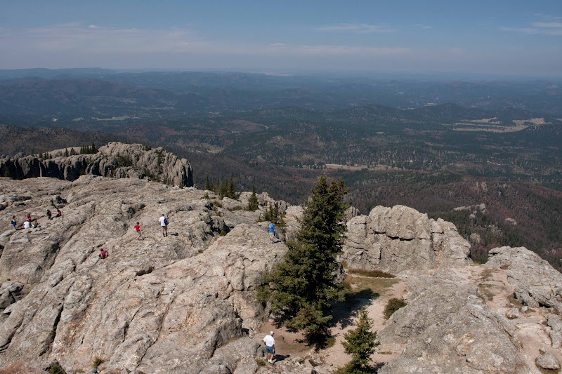
The amazing view from on high

The view on top is breathtaking.  The entire Black Hills spreads out before you in all directions.  The granite spires of the Needles and Mt. Rushmore rise up from the dark forests.  On a clear day, you can see the plains of eastern South Dakota, Nebraska, and Wyoming far into the distance.  Luckily, we hiked on a sunny day and was able to take full advantage of such a fantastic panorama.


Perched on the wall

Two of my brothers and both nephews ventured out onto the wide granite ridgetop below the tower.  Standing on the balcony, I was content to watch the other people explore this area.

  
Four-state view from the tower

Even though we hiked on a weekday, there was still plenty of people on and around the summit.  The Harney Peak Trail is extremely popular.  It's a moderate enough hike for most healthy people to complete.  We even saw a group on horseback - the Forest Service provides hitching posts at the tower's base.


Rock wall close-up
 
After refueling with a snack, and taking copious shots of the tower and it's grand views, I climbed to the lookout's upper story.  Peering out through spacious windows, I tried to imagine what it must've been like to be a forest ranger living here.  Not a bad job!
 

Group photo to prove we all made it

After spending well over an hour admiring the views, my family and I decided it was time to head back down.  Although gravity was now on our side, descending can sometimes be more difficult than climbing.  


Window views from the tower's upper story

But everyone made it down just fine - even my 75-year old father.   My parents are amazing!  Both in their 70s, they had no trouble with this 7-mile round trip, 1000 feet plus hike.  My dad slowed down a bit on the descent, but with my camera, I hike slow too.  So I had a companion all the way back.  (And when my parents finished this hike, they had to rush into town as they were scheduled to play a round of golf with their couples league!)


Looking back to where I'd been

So nice to visit a favorite hike from my childhood!  It was a wonderful day spent on the trail with my family.  The Black Hills will always be a special place to me.  I'm glad I got a chance to visit again.
 
If you ever find yourself in the Black Hills of South Dakota, this hike is not to be missed!